Showing 10386 items
matching plan
-
 Federation University Historical Collection
Report, Ballarat School of Mines Planning Officer's Report to Council, 1978, 10/1978
Report from the Ballarat School of Mines Planning Officer . Planning Document 41.78ballarat school of mines, planning documet, j.l. turner, planning officer -
 Kew Historical Society Inc
Booklet, Sands & McDougall, Rules and Regulations, Boroondara General Cemetery, 1911
The 31-acre (13 ha) cemetery site was reserved in 1855 and trustees were first appointed in 1858. A site plan was drawn up by Frederick Acheson, a civil engineer in the Public Lands Office, with the layout segregated by religious denomination, a common occurrence at the time. The first burial took place in 1859. The rules were gazetted rather than published as guidelines as the cemetery was constituted under and act of parliament. Early publication about the Boroondara General Cemetery which, in addition to providing public guidelines, reflects the social and spiritual values of the period.Rules and regulations of the Boroondara General Cemetery. Published in by Sands & McDougall Ltd, Collins St. Gazetted 10th November, 1893. 24pp. The booklet includes a plan of the cemetery.rules and regulations -- cemeteries -- victoria, boroondara general (kew) cemetery -
 Federation University Historical Collection
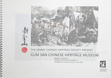
Plan, The Ararat Chinese Heritage Society Present Gum San Chinese Heritage Museum Concept Design and Development
Dick de Fegley who was on the University of Ballarat Council was highly involved with the development of Gum San Museum. University of Ballarat is a predecessor of Federation University.A3 document containing plans and information pertaining to the development of Gum San Chinese Heritage Museumdick de fegely, gum san chinese heritage museum, challis design, ararat chinese heritage society -
 Federation University Historical Collection
Plan, Ballarat Goldfields Geological Survey, 1981
Large coloured plan showing streets, leads, geological zones and shafts. Source 1:10,000ballarat, gold, goldfield, geology, sebastopol -
Federation University Historical Collection
Plan - Plans, University of Ballarat Plans for the Library Refurbishment creating the Geoffrey Blainey Research Centre at Mount Helen Campus, 2009, 11/2009
The E.J. Barker Library on the University of Ballarat (now federation University) campus was refurbished in 2009. Six A3 plans by Demaine of the Reading room and storage facility of the Geoffrey Blainey Research Centre.university of ballarat, geoffrey blainey research centre, demaine, refurbishment, library, mt helen library, e.j. barker library, library plan, mt helen library plan, gbrc -
Port Melbourne Historical & Preservation Society
Plan - Berthing of HMY Britannia, HMAS Vampire/Torrens, Port of Melbourne Authority
Plan re berthing of HMY Britannia and HMAS Vampire/Torrens, and Royal Promenade Deck location.Traffic direction indicators in red, green, orange inks. Barriers indicated in red ink. Vampire crossed out, Torrens written above in pencil. Lifts and some areas of Waiting Hall marked in orange felt-tip.piers and wharves - station pier, royal visits and occasions, melbourne harbor trust - port of melbourne authority -
Port Melbourne Historical & Preservation Society
Plan - Cutting and filling, Ingles Street from Station Place to Crockford Street, 1860 - 1874
Plan for cutting and filling re Ingles St, and cross streets Station Place to Crockford St."Borough Surveyor's Office Sandridge" upper right hand corner on face.engineering - roads streets lanes and footpaths -
Port Melbourne Historical & Preservation Society
Plan - House, 16 McCormack Street, Port Melbourne, 2000s
Plan of house 16 McCormack Street Port Melbourne. Property owned by Eileen Mary Gilcristfamilies, domestic life, john gilcrist, john james gilcrist, mary eileen gilcrist, mccormack street -
Port Melbourne Historical & Preservation Society
Plan - Shelter shed, Borough of Sandridge, Mar 1877
Hand drawn plan and elevation of tiny shelter shed "at manure depot in common", Sandridge 1877.Signed by Edward Wilson and Charles Clay (Surveyor)local government - borough of sandridge, built environment - civic, edward wilson, charles clay -
Port Melbourne Historical & Preservation Society
Plan - Drainage works, cnr Crockford and Raglan Streets, Sandridge, George Kelly, Borough Surveyor, 3 Jun 1864
Sectional plan for drainage work after flood 1864. Corner Crockford Street and Raglan Street.Borough of Sandridgeengineering department - borough of sandridge, engineering - canals and drainage, business and traders - hotels, george kelly -
Port Melbourne Historical & Preservation Society
Plan - Drainage works, cnr Crockford and Raglan Streets, Sandridge, George Kelly, Borough Surveyor, 6 Jun 1864
Ground plan for drainage work after flood 1864. Corner Crockford Street and Raglan Street.Borough of Sandridgeengineering department - borough of sandridge, engineering - canals and drainage, business and traders - hotels, george kelly -
Port Melbourne Historical & Preservation Society
Plan - Proposed land sub-division, west of railway, Sandridge, 19 Nov 1866
1866 plan of proposed sub-division of land at Sandridge, west of railway. Includes manure depot.J. Noone (Photolithographer, Dept. of Lands and Survey) J. Hardy (Assistant Surveyor)town planning, town planning - proposals shelved, j noone, j hardy -
Port Melbourne Historical & Preservation Society
Plan - Wharf area behind Berth Numbers 25, 26 & 27 South, Engineering Division, Port of Melbourne Authority, 1970
Plan - General layout of wharf area behind berth No.s 25,26 & 27 South, 1970smelbourne harbor trust - port of melbourne authority -
Port Melbourne Historical & Preservation Society
Plan - Proposed street layout for North Sandridge, 1870
Plan of proposed street layout for North Sandridge to illustrate handwritten proposal (Reg. No. 127.1) 1870town planning - proposals shelved, james blackburn -
Port Melbourne Historical & Preservation Society
Plan - Pipe system, London Hotel, Port Melbourne, 15 Feb 1965
Photocopies (2) of black / white plan of part combined pipe system for London Hotel. 1965local government - city of port melbourne, london family hotel -
Moorabbin Air Museum
Plan (item) - Vickers Viking Civil Transport Hercules Engines Drawing Drg 45381 Sheet 1 Issue B Sheet 2 Issue B Sheet 3 Issue B F.L.R. June 1946 P.B. January 1947
vickers-armstrong viking civil transport aircraft -
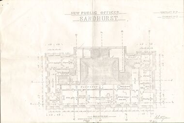 Bendigo Historical Society Inc.
Plan - NEW PUBLIC OFFICES SANDHURST
Photocopy of Plan for New Public Offices Sandhurst 1883-1887 - Drawing No3/Contract No2bendigo, planning, sandhurst -
University of Melbourne, Burnley Campus Archives
Plan (Item), Gibson North Island Bed 1:50 Nov. '17, 2017 - 2019
-
University of Melbourne, Burnley Campus Archives
Plan (Item), Burnley Campus School of Ecosystem and Forest Sciences
university of melbourne, burnley campus, property & buildings -
University of Melbourne, Burnley Campus Archives
Plan, 68-70 Dorcas St South Melbourne, 1989
Site/Roof plan by David Earle & Associates, Project No 1189 Drawing No A1. Designed by D.F.david earle -
University of Melbourne, Burnley Campus Archives
Plan, Landscape Construction, 1960-1990
Miscellaneous plans on tracing paper and paper related mainly to Landscape Construction (approx. 40 sheets)landscape construction -
University of Melbourne, Burnley Campus Archives
Plan, Power Tool Practical, 1980-1990
Tracing paper and paper copies of plan of where to put bolts and nails in a piece of construction work.tools, construction -
University of Melbourne, Burnley Campus Archives
Plan, Geoff Olive, Geoff Olive Notes, 16.05.2015
site plan, campus plan, geoff olive, history -
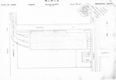 Melbourne Tram Museum
Drawing, Melbourne & Metropolitan Tramways Board (MMTB), "Brunswick Depot", c1937
Set of three photocopied plans or drawings on A3 sheet of Brunswick Depot - dated 30-6-1937 .1 - P8142 - Plan showing depot block and building plan .2 - P8144 - Detail plan of depot .3 - P8146 - Plan of Mess Room above depot offices / basement.trams, tramways, drawings, depots, property, brunswick depot -
 Kew Historical Society Inc
Plan - Subdivision Plan, Jas R Mathers Son & McMillan, East Kew Tramway Estate, 1915
Pru Sanderson, in her groundbreaking ‘City of Kew Urban Conservation Study : Volume 2 - Development History’ (1988), summarised the periods of urban development and subdivisions of land in Kew. The periods that she identified included 1845-1880, 1880-1893, 1893-1921, 1921-1933, 1933-1943, and Post-War Development. These periods were selected as they represented periods of rapid growth or decline in urban development. An obvious starting point for Sanderson’s groupings involved population growth and the associated economic cycles. These cycles also highlighted urban expansion onto land that was predominantly rural, although in other cases it represented the decline and breakup of large estates. A number of the plans in the Kew Historical Society’s collection can also be found in other collections, such as those of the State Library of Victoria and the Boroondara Library Service. A number are however unique to the collection.The Kew Historical Society collection includes almost 100 subdivision plans pertaining to suburbs of the City of Melbourne. Most of these are of Kew, Kew East or Studley Park, although a smaller number are plans of Camberwell, Deepdene, Balwyn and Hawthorn. It is believed that the majority of the plans were gifted to the Society by persons connected with the real estate firm - J. R. Mathers and McMillan, 136 Cotham Road, Kew. The Plans in the collection are rarely in pristine form, being working plans on which the agent would write notes and record lots sold and the prices of these. The subdivision plans are historically significant examples of the growth of urban Melbourne from the beginning of the 20th Century up until the 1980s. A number of the plans are double-sided and often include a photograph on the reverse. A number of the latter are by noted photographers such as J.E. Barnes.The East Kew Tramway Estate was a subdivision of two separate parcels of land between Adeney Avenue and Normanby Road. The larger section included 54 lots facing Adeney Avenue, Argyle Road, and Campbell, Hunter and Wishart Streets. [Hunter and Wishart Streets were created as part of the subdivision.] A further 17 allotments faced Normanby Road, Hubert and Campbell Streets. [The name of Hubert Street was later to be changed to Cecil Street.] The promotion of the sale referred to the advantages of living between two tram routes, in High Street and Cotham Road. On the plan, quaintly drawn trams mark these routes. Also on the plan is the route of part of the Outer Circle [Railway] Line.east kew tramway estate, subdivision plans - east kew -
Bendigo Historical Society Inc.
Document - MARKS COLLECTION: GROUND AND SURFACE WORKINGS BALLERSTEDT MINE VICTORIA HILL
a. Plan (original in poor condition, torn in centre) Also, plan (copy of original) and report stapled to copy of plan. On top of plan 'Plan showing the position of the ground and surface workings in the claim of Mr. Ballerstedt Victoria Hill' Plan is signed by Thomas Forbes, Mining Surveyor, 22nd. April 1868. Plan shows house outline and open cut. Report is labelled 'Report accompanying plan on the underground working on .? Ballerstedt & Sons Claim, Victoria Hill' Handwritten 2 page report details the state of the timbering and a slip that occurred.bendigo, mining, ballerstedt mine victoria hill -
 University of Melbourne, Burnley Campus Archives
Plan, L.R.B. Simmons, New Soil Science Laboratory, 1973
Plans by Govt. Of Victoria Public Works Dept.: L.R.B. Simmons (Senior Project Architect), D.C. Bradbury (Chief Architect), Drawn by Aldo Bellarmo. A. Proposed addition to existing laboratory. B. Plan of Section and Elevation of proposed new Soil Science laboratory.laboratory, glasshouse, l.r.b. simmons, d.c. bradbury, aldo bellarmo -
 RMIT Design Archives
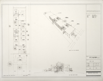
Architectural drawings, Proposed Family Residence for Mr. & Mrs. Spedding at Lot 2 Bolton Avenue, Brighton
Sketh plansink, acetate -
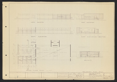
 University of Melbourne, Burnley Campus Archives
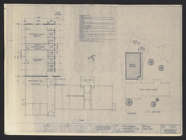
Plan, VCAH Burnley Proposed Plant Laboratory, 1989
This must have been put out for tender - no information on which was used1. Site Plan Floor Plan Job No. 89038. Drawing No. SKA001 by Godfrey and Spowers Australia Pty. Ltd. Scale 1:100, 1:200 X 4. 2. Proposed Laboratories & Offices at Swan Street, Richmond for VCAH-Burnley. College of Horticulture: Floor Plan, Section A-A, Elevation 1, 2, 3 and $. Sheet No. 8952 WD2 by Fooks Martin Sandow Pty Ltd. Scale 1:100vcah, burnley, laboratory, fooks martin sandow p/l, godfrey and spowers australia p/l -
 Ringwood and District Historical Society
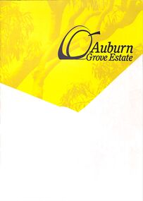
Pamphlet - Land Sale Brochure, Auburn Grove Estate Ringwood East - circa 2012
Estate offers country living in the heart of the leafy eastern suburbs flanking Tintern Grammar School farm.Trifold pamphlet advertising Auburn Grove Estate with maps and layout of subdivision and photographs of area. No dates.Estate plan includes Longview Road, Auburn Grove, and Gracedale Avenue.