Showing 3382 items
matching bridge road
-
 Eltham District Historical Society Inc
Photograph, Upper Yarra Dam, Spring Tour, 22 Oct 1995, 22/10/1995
EXPLORING THE UPPER YARRA (Newsletter No. 105, November 1995, by Bettina Woodburn) We enjoyed the Spring Excursion, this year "Exploring the Upper Yarra" - in spite of the constant rain and the countryside under the cloud cover, especially in the valleys, being mainly shiny shades of green. The occasional fields of buttercups, clumps of arum lilies and splendid rhododendron and other flowering bushes became very special. The Cobb and Co coach was warm and a cosy retreat as we zig-zagged on the highways and byways to glimpse the Yarra River, upstream and down, its secret places, and particularly the many bridges. Russell excelled as 'Poet Laureate', reading from Dacre Smyth's book. This 1979 publication includes paintings of all the bridges along the river with poems and brief descriptions of each one. Some of the bridges are in out of the way places and are not very well known. We looked forward to hearing the poetry as much as seeing the ' constructions'…Big Pat (was he short or tall, lean or fat? He did win the two hundred pound reward for discovering gold and had the creek named after him), about the 'Eddies'?, and the disliked 'meccano' bridge in Warburton, etc. etc. The hot roast lunch in the old Reefton Hotel was also most welcome. It was easy to imagine it peopled by miners and early settlers. Starting by crossing the new (1974) concrete bridge at Warrandyte we headed through Wonga Park with views to the Christmas Hills and to the escarpment of the Yering Gorge, which causes flood waters to back up through the Yarra Glen plain, so avoiding disasters downstream. At the end of a long driveway we found the wooden, privately owned Henley Bridge (1935 after the 1934 floods). This facilitates access to different parts of Henley Farm and to Lilydale. Everard Park, named after Blanche Shallard's father, a State Member for 17 years, below the Highway Yarra crossing was in need of care. It is 10 miles from Yarra Glen by road but, as "Yarra Marra” canoeists well know, 32 winding miles down by water. After more delightful countryside scenes we joined the Warburton Highway at Woori Yallock. From the old Railway Station at Launching Place the Centennial Trail for walkers, cyclists and ' horse riders has replaced the rails. The line from Lilydale was opened in 1901, and the last diesel freight train ran to Warburton in 1965. It continued to rain as we had morning tea in Warburton in a shelter between footbridges. From here we continued upstream past the Bridge to O'Shannasy Lodge and Reservoir, Starvation Creek, and the Peninsular tunnel (miners dug it as at Pound Bend) which we visited (scrambling down those steps!) on our return after lunch. Our furthermost point was the Upper Yarra Dam Reserve (and vast catchment area). Finished in 1957 after ten years work and 100 years after Yan Yean, it supplies much of Melbourne's water. After crossing the 30m Launching Place Bridge to the Eltham side of the Yarra and Healesville, we saw in the distance the Yarra Glen Timber Trestle Bridge over the river flats "the longest for years in the land it was said!" Harry's dream of "better weather over the Divide" unfortunately didn't come true, but I'm sure we 36 members will retain happy memories of a day that was wet and green and filled with Bridges. Bettina Woodburn - October 1995 Record of the Society's history of activities - Spring 1995 excursionRoll of 35mm colour negative film, 2 stripsKodak Gold 100-4shire of eltham historical society, activities, upper yarra dam, henley bridge -
 Eltham District Historical Society Inc
Photograph, Upper Yarra Dam, Spring Tour, 22 Oct 1995, 22/10/1995
EXPLORING THE UPPER YARRA (Newsletter No. 105, November 1995, by Bettina Woodburn) We enjoyed the Spring Excursion, this year "Exploring the Upper Yarra" - in spite of the constant rain and the countryside under the cloud cover, especially in the valleys, being mainly shiny shades of green. The occasional fields of buttercups, clumps of arum lilies and splendid rhododendron and other flowering bushes became very special. The Cobb and Co coach was warm and a cosy retreat as we zig-zagged on the highways and byways to glimpse the Yarra River, upstream and down, its secret places, and particularly the many bridges. Russell excelled as 'Poet Laureate', reading from Dacre Smyth's book. This 1979 publication includes paintings of all the bridges along the river with poems and brief descriptions of each one. Some of the bridges are in out of the way places and are not very well known. We looked forward to hearing the poetry as much as seeing the ' constructions'…Big Pat (was he short or tall, lean or fat? He did win the two hundred pound reward for discovering gold and had the creek named after him), about the 'Eddies'?, and the disliked 'meccano' bridge in Warburton, etc. etc. The hot roast lunch in the old Reefton Hotel was also most welcome. It was easy to imagine it peopled by miners and early settlers. Starting by crossing the new (1974) concrete bridge at Warrandyte we headed through Wonga Park with views to the Christmas Hills and to the escarpment of the Yering Gorge, which causes flood waters to back up through the Yarra Glen plain, so avoiding disasters downstream. At the end of a long driveway we found the wooden, privately owned Henley Bridge (1935 after the 1934 floods). This facilitates access to different parts of Henley Farm and to Lilydale. Everard Park, named after Blanche Shallard's father, a State Member for 17 years, below the Highway Yarra crossing was in need of care. It is 10 miles from Yarra Glen by road but, as "Yarra Marra” canoeists well know, 32 winding miles down by water. After more delightful countryside scenes we joined the Warburton Highway at Woori Yallock. From the old Railway Station at Launching Place the Centennial Trail for walkers, cyclists and ' horse riders has replaced the rails. The line from Lilydale was opened in 1901, and the last diesel freight train ran to Warburton in 1965. It continued to rain as we had morning tea in Warburton in a shelter between footbridges. From here we continued upstream past the Bridge to O'Shannasy Lodge and Reservoir, Starvation Creek, and the Peninsular tunnel (miners dug it as at Pound Bend) which we visited (scrambling down those steps!) on our return after lunch. Our furthermost point was the Upper Yarra Dam Reserve (and vast catchment area). Finished in 1957 after ten years work and 100 years after Yan Yean, it supplies much of Melbourne's water. After crossing the 30m Launching Place Bridge to the Eltham side of the Yarra and Healesville, we saw in the distance the Yarra Glen Timber Trestle Bridge over the river flats "the longest for years in the land it was said!" Harry's dream of "better weather over the Divide" unfortunately didn't come true, but I'm sure we 36 members will retain happy memories of a day that was wet and green and filled with Bridges. Bettina Woodburn - October 1995 Record of the Society's history of activities - Spring 1995 excursionRoll of 35mm colour negative film, 4 of 5 stripsKodak Gold 400-5shire of eltham historical society, activities, upper yarra dam, henley bridge -
 Eltham District Historical Society Inc
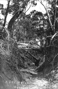
Negative - Photograph, Tom Prior, A Dry Water-course - Research, Vic, c.1895
This water course starts at Mount Pleasant Road, Research. Part of a slide show presentation "Bridges & Waterways of the Shire" by Russell Yeoman to the 13 September 1989 Society meeting. The presentation included slides of historic photos from the Shire of Eltham Pioneers collections as well as several recent views.This photo forms part of a collection of photographs gathered by the Shire of Eltham for their centenary project book,"Pioneers and Painters: 100 years of the Shire of Eltham" by Alan Marshall (1971). The collection of over 500 images is held in partnership between Eltham District Historical Society and Yarra Plenty Regional Library (Eltham Library) and is now formally known as the 'The Shire of Eltham Pioneers Photograph Collection.' It is significant in being the first community sourced collection representing the places and people of the Shire's first one hundred years. The Reynolds family were early settlers in Research. The Reynolds/ Prior collection of photographs were taken by Tom Prior, the maternal uncle of Ivy Reynolds, around 1900 and the 60 photos in the album give a fine overview of many of the landmarks of Research and Eltham over 100 years ago. lvy lived in the family home for many years at 106 Thompson Cres Research. Ivy's father, Ernst Richard Reynolds and grandfather, Richard Reynolds, lived at the same address. Ivy's father Richard worked for Mr. Trail on his property in Research. Reynolds Road is named after the family. Mr Tom Prior (wife Eva) worked at the Melbourne zoo. He was very innovative and made his own camera, using the black cloth hood to exclude the light. The photographs are a reminder of the rural nature of Research and Eltham and its rich heritage.Digital image 4 x 5 inch B&W Negshire of eltham pioneers photograph collection, research (vic.), creek, mount pleasant road, reynolds prior collection -
 Eltham District Historical Society Inc
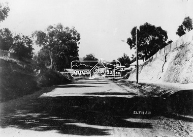
Negative - Photograph, J.H. Clark, Main Road, Eltham, c.1908
... of eltham pioneers photograph collection eltham main road gahan ...Gahan house on left, bakery on right at corner of York Street, Shillinglaw Cottage in distance. Newly constructed footpath (refer SEPP_0616) on eastern side between York Street and Bridge Street. Photo by J.H. Clark - John Henry Clark was one of four brothers that ran a photography business, Clark Bros. from 25 Thomas Street, Windsor between c.1894 and 1914. Source: Mr. L. Jarrold, Dromana, (formerly Eltham) Photographer: J.H. Clark John Henry Clark was the youngest of three boys born to William Henry Clark (1823-1877) and Maria White (1843-1914). He and his brothers, William Charles Clark (1872-1945), Clement Kent Clark (1874-1912) operated a photography business (Clark Bros.) from 25 Thomas Street, Windsor near Prahran during the period c.1894 to 1914. Following death of Clement in September 1912 and their mother in 1914, the Clark Bros business appears to have dissolved, the premises demolished, and a new house was under construction in 1915. John set up business independently in 1914 operating out of 29 Moor Street, Fitzroy where he is registered in the 1914 and 1915 Electoral Rolls. By 1916 John had relocated to Eltham where he continued his practice as a photographer and took many of the early images around the district of Little Eltham. Around 1930 John changed professions and opened a small cobbler's shop in 1931 near the pond opposite Dalton Street adjacent to the Jarrold family cottage. He never married and continued his profession as a bootmaker from this little shop, maintaining a close relationship with Mrs Jarrold for the rest of their lives. His bootmaker shop remains today beside the Whitecloud cottage and is one of only three remaining shops in the area from the early 20th century. There are a couple of images of Eltham taken by Clark Bros. in the Eltham District Historical Society collection, one such example being Hunniford’s Post Office with Miss Anne Hunniford out front (EDHS_00140 - marked on the back of the print, Clark Bros., 25 Thomas St. Windsor), which would date this image between c.1894 and 1914. Other early images of Eltham taken by John Henry Clark are marked on the face “J. H. Clark Photo” and it is assumed these are dated between 1914 and 1930. It is noted that the Grant of Probate for John H Clark of Eltham South dated 5 April !957 (513/387) records his occupation as "X Photographer".This photo forms part of a collection of photographs gathered by the Shire of Eltham for their centenary project book,"Pioneers and Painters: 100 years of the Shire of Eltham" by Alan Marshall (1971). The collection of over 500 images is held in partnership between Eltham District Historical Society and Yarra Plenty Regional Library (Eltham Library) and is now formally known as the 'The Shire of Eltham Pioneers Photograph Collection.' It is significant in being the first community sourced collection representing the places and people of the Shire's first one hundred years.Digital image 4 x 5 inch B&W NegJ.H. Clark Photoshire of eltham pioneers photograph collection, eltham, main road, gahan house, bakery, bridge street, footpath, j.h. clark photo, shillinglaw cottage, shillinglaw trees, york street -
 Eltham District Historical Society Inc
Negative - Photograph, Diamond Creek, Eltham. Old Diamond Street Bridge, c.1919
Copy of Rose Series Postcard P. 4314. (The Rose Stereograph Company) Shows two bridge crossings over the Diamond Creek in Diamond Street, Eltham. The upper pedestrian crossing provided continual access for foot traffic during times of flood. The railway came to Eltham in 1901, the Eltham Railway Station is visible in the distance as well as a wooden bodied Tait (Red Rattler) First Class train carriage. The Tait train was first introduced in 1910 as a steam locomotive hauled carriage and in 1919 electric motor carriages were introduced however the line to Heidelberg was not electrified till 1921 and to Eltham in April 1923. The Railway General Store on Main Road is visible beyond the station and was built by Luther Haley in 1902. It was the first shop in the present day shopping centre. It was later known as lloyd's stopre (1917-1920) followed by a succession of six other owners until purchased by Eric Staff in 1939. George Rose founded the Rose Stereograph Company in 1880 and was joined by Herbert (Bert) Cutts in the early 20th Century. The pair formed a lifetime working partnership and strong personal friendship. Assisted by George’s two sons, Herbert George and Walter, and later by Neil Cutts, the Rose Stereograph Company continued its operations for more than 140 years. The company was initially built on stereographs, but as cinema took over and stereographs fell out of fashion, the Rose Stereograph Company developed Australia’s first commercially viable photographic postcard business. Specialising in postcards of iconic historical moments and significant landmarks, The Rose Stereograph Company became a staple of the Australian travel industry.This photo forms part of a collection of photographs gathered by the Shire of Eltham for their centenary project book,"Pioneers and Painters: 100 years of the Shire of Eltham" by Alan Marshall (1971). The collection of over 500 images is held in partnership between Eltham District Historical Society and Yarra Plenty Regional Library (Eltham Library) and is now formally known as 'The Shire of Eltham Pioneers Photograph Collection.' It is significant in being the first community sourced collection representing the places and people of the Shire's first one hundred years.Digital image 4 x 5 inch B&W Negdiamond creek, diamond street bridge, eltham, eltham railway station, glass plate negative, lloyd's general store, postcard, railway station, railway store, rose series postcard, rose stereograph company, shire of eltham pioneers photograph collection, staffs general store, tait train, travel -
 Eltham District Historical Society Inc
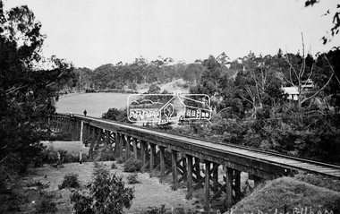
Negative - Photograph, Tom Prior, Railway Trestle Bridge over the Diamond Creek, Eltham, Vic, c.1910
... street Main Road Reynolds Prior Collection trestle bridge Digital ...Railway Trestle Bridge over the Diamond Creek, Eltham, c.1910 - looking towards Main Road (left to right) and Henry Street (centre). Built in 1901, the railway line was electrified in 1923. Photo was taken prior to 1912 and the relocation of the new St Mary’s Catholic Church on Henry Street near Main Road (or Maria Street). The church site was relocated c.1912 from further south along Main Road (near Wingrove Cottage) to be more central to the congregation following the shifting of the township away from Little Eltham and closer to the railway station. It was subsequently destroyed by fire in 1961.This photo forms part of a collection of photographs gathered by the Shire of Eltham for their centenary project book,"Pioneers and Painters: 100 years of the Shire of Eltham" by Alan Marshall (1971). The collection of over 500 images is held in partnership between Eltham District Historical Society and Yarra Plenty Regional Library (Eltham Library) and is now formally known as the 'The Shire of Eltham Pioneers Photograph Collection.' It is significant in being the first community sourced collection representing the places and people of the Shire's first one hundred years. The Reynolds family were early settlers in Research. The Reynolds/ Prior collection of photographs were taken by Tom Prior, the maternal uncle of Ivy Reynolds, around 1900 and the 60 photos in the album give a fine overview of many of the landmarks of Research and Eltham over 100 years ago. lvy lived in the family home for many years at 106 Thompson Cres Research. Ivy's father, Ernst Richard Reynolds and grandfather, Richard Reynolds, lived at the same address. Ivy's father Richard worked for Mr. Trail on his property in Research. Reynolds Road is named after the family. Mr Tom Prior (wife Eva) worked at the Melbourne zoo. He was very innovative and made his own camera, using the black cloth hood to exclude the light. The photographs are a reminder of the rural nature of Research and Eltham and its rich heritage.Digital image 4 x 5 inch B&W Negshire of eltham pioneers photograph collection, bridge, diamond creek (creek), eltham, eltham railway trestle bridge, henry street, main road, reynolds prior collection, trestle bridge -
 Eltham District Historical Society Inc
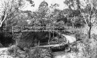
Negative - Photograph, Tom Prior, Langlands Bridge, Eltham, c.1900
It is noted in the Reynolds Prior collection (Ivy Reynolds) as the first bridge in Eltham however given the current state of knowledge, this is considered unlikely and there is no other supporting source. John Hunter Langlands, owner of the farm known as ‘Ihurst’ on the west side of Diamond Creek to the south of John Wright Murray’s land, died in 1907. In 1909 his land was subdivided into 100 lots to become the ‘Glen Park Estate’. It is possible that the bidge may have crossed the Diamond Creek to Langland's land along the original alignment of Glen Park Road which used to run between present day Progress Road and Coleman Crescent. SEPP Source (c.1970): Mrs. E.R. Reynolds, Thompson Crescent, Research The Reynolds family were early settlers in Research. The Reynolds/ Prior collection of photographs were taken by Tom Prior, the maternal uncle of Ivy Reynolds, around 1900 and the 60 photos in the album give a fine overview of many of the landmarks of Research and Eltham over 100 years ago. lvy lived in the family home for many years at 106 Thompson Cres Research. Ivy's father, Ernst Richard Reynolds and grandfather, Richard Reynolds, lived at the same address. Ivy's father Richard worked for Mr. Trail on his property in Research. Reynolds Road is named after the family. Mr Tom Prior (wife Eva) worked at the Melbourne zoo. He was very innovative and made his own camera, using the black cloth hood to exclude the light. The photographs are a reminder of the rural nature of Research and Eltham and its rich heritage. This photo forms part of a collection of photographs gathered by the Shire of Eltham for their centenary project book,"Pioneers and Painters: 100 years of the Shire of Eltham" by Alan Marshall (1971). The collection of over 500 images is held in partnership between Eltham District Historical Society and Yarra Plenty Regional Library (Eltham Library) and is now formally known as the 'The Shire of Eltham Pioneers Photograph Collection.' It is significant in being the first community sourced collection representing the places and people of the Shire's first one hundred years.Digital image 4 x 5 inch B&W Neg B&W printsepp, shire of eltham pioneers photograph collection, eltham, langlands bridge, reynolds prior collection, bridge, john hunter langlands -
 Eltham District Historical Society Inc
Negative - Photograph, George W. Bell, Excavation of site for new Eltham Shire Office building, 895 Main Road, Eltham, 1964
Black and white photograph of bulldozer excavating the former Shillinglaw Cottage site for new Shire Offices. 'Shillinglaw Trees' in background. The cottage and land were purchased by the Shire of Eltham as the site for a new shire office building. The cottage was destined for demolition but members of the community concerned at losing one of the areas earliest buildings (built c.1859) initiated a fund-raising campaign to save the cottage. In 1964 the cottage was dis-assembled, all the bricks numbered and reassembled several hundred meters to the south on a site between the Gahan house and the Eltham Railway Trestle Bridge (present-day Panther Place), which became known as the Eltham Common. The new shire offices at 895 Main Road were opened in 1965. Following the Kennett Government amalgamation of local government areas in 1994, the Shire of Eltham ceased to exist, and a new Shire of Nillumbik was created 15 December 1994 from the former Eltham shire and parts of the Diamond Valley shire. The former West Riding which included parts of Montmorency, Lower Plenty and Briar Hill were ceded to the new City of Banyule. Commissioners were appointed for several years and the new Council occupied the former offices of the Shire of Diamond Valley in Greensborough. The former Eltham Shire offices remained vacant until August 1996 the Commissioners suddenly elected to have the former Shire offices demolished immediately and the site has remained vacant ever since. It was not until 1997 before the community was allowed to democratically elect new Councillors to represent them. This photo forms part of a collection of photographs gathered by the Shire of Eltham for their centenary project book,"Pioneers and Painters: 100 years of the Shire of Eltham" by Alan Marshall (1971). The collection of over 500 images is held in partnership between Eltham District Historical Society and Yarra Plenty Regional Library (Eltham Library) and is now formally known as the 'The Shire of Eltham Pioneers Photograph Collection.' It is significant in being the first community sourced collection representing the places and people of the Shire's first one hundred years.Digital image 4 x 5 inch B&W Negeltham, eltham shire office, excavation, george w. bell collection, main road, municipal offices, shillinglaw cottage, shillinglaw trees, shire of eltham pioneers photograph collection, shire offices, significant tree -
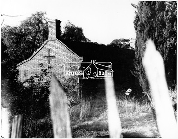 Eltham District Historical Society Inc
Negative - Photograph, George W. Bell, Shillinglaw Cottage, Main Road, Eltham, c.1964
Shillinglaw Cottage on its original site (present day 895 Main Road) showing old picket fence c.1964. The cottage and land were purchased by the Shire of Eltham as the site for a new shire office building. The cottage was destined for demolition but members of the community concerned at losing one of the areas earlist buildings (built c.1859) initiated a fund-raising campaign to save the cottage. In 1964 the cottage was dis-assembled, all the bricks numbered and reassembled several hundred meters to the south on a site between the Gahan house and the Eltham Railway Trestle Bridge (present-day Panther Place), which bcame known as the Eltham Common.This photo forms part of a collection of photographs gathered by the Shire of Eltham for their centenary project book,"Pioneers and Painters: 100 years of the Shire of Eltham" by Alan Marshall (1971). The collection of over 500 images is held in partnership between Eltham District Historical Society and Yarra Plenty Regional Library (Eltham Library) and is now formally known as the 'The Shire of Eltham Pioneers Photograph Collection.' It is significant in being the first community sourced collection representing the places and people of the Shire's first one hundred years.Digital image 4 x 5 inch B&W Negsepp, shire of eltham pioneers photograph collection, eltham, shillinglaw cottage, fences, george w. bell collection, houses, main road -
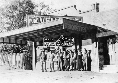 Eltham District Historical Society Inc
Negative - Photograph, Burgoyne family outside J.N. Burgoyne's Store, Main Road, Eltham, Vic, 1940
... of Bridge Street (present day No. 820 Main Road). An extension... south of Bridge Street (present day No. 820 Main Road ...The store built in 1925 was located on Main Road just south of Bridge Street (present day No. 820 Main Road). An extension was added to the right in 1939. The store was built in late 1925 at the same time as Mr C. Nicholls’s new store was constructed. Both were considered modern shops, and an improvement on most, business establishments of the time. Mr. Nicholls’s store included alongside it a modern, weatherboard villa residence. Mr. Burgoyne’s store incorporated the post and telegraph office, which was operated by John Neville Burgoyne’s half-aunt, Miss Anne Hunniford until her death in 1928 at which time J.N. Burgoyne became postmaster. The unsealed footpath in front is reasonably extensive as not visible is a concrete kerb and channel which was laid from the Post Office to John Street during Nov-Dec 1926. Footpath construction in front of Burgoyne’s store commenced August 1942. The extension to the right of the store was erected in 1939 for a new telephone exchange adjacent to the store and post office. A continuous telephone service operated by Mr Burgoyne and his family commenced operation 18 November 1939. Approximately 70 extensions were routed through the new exchange, 40 of which were transferred from the Greensborough Exchange. Entry to the exchange was via a separate door on Main Road or via the shop. The public telephone was initially mounted on the wall but later moved to the street. Cross Ref: 0701 of the store c.1934This photo forms part of a collection of photographs gathered by the Shire of Eltham for their centenary project book,"Pioneers and Painters: 100 years of the Shire of Eltham" by Alan Marshall (1971). The collection of over 500 images is held in partnership between Eltham District Historical Society and Yarra Plenty Regional Library (Eltham Library) and is now formally known as the 'The Shire of Eltham Pioneers Photograph Collection.' It is significant in being the first community sourced collection representing the places and people of the Shire's first one hundred years.Digital image 4 x 5 inch B&W Negshire of eltham pioneers photograph collection, burgoyne's shop, eltham, main road, post office, shops -
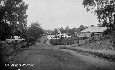 Eltham District Historical Society Inc
Negative - Photograph, Main Road, Eltham, c.1915
... in albums. This scene is viewed looking north along Main Road from... in albums. This scene is viewed looking north along Main Road from ...Sending postcards to family and friends including short messages was a common form of communication in the early 20th century from 1905 to the 1940s. Many were collected and kept in albums. This scene is viewed looking north along Main Road from near Bridge Street. The old Baker’s shop (Burgoyne’s store) on the corner of York is on the right. Also visible is the footpath dug by hand c.1906 between Yoirk Street and Bridge Street. On the left is ‘Derril’ or more commonly known as the Gahan House after it was purchased by Walter Ernest and Alice Miriam Gahan in 1924, on the western side of Main Road near the present-day site of Shillinglaw Cottage where they remained till about 1960 when Walter died. The house was demolished in 1968 during the widening of Main Road. In the distance on the bend is the Shillinglaw cottage with the Shillinglaw trees out front of the cottage. On the eastern side at the top of the hill (visible immediately to the left of the bakery) is the new St Mary’s Catholic Church on Henry Street near Main Road. The church site was relocated c.1912 from further south along Main Road (near Wingrove Cottage) in order to be more central to the congregation following the shifting of the township away from Little Eltham and closer to the railway station. It was subsequently destroyed by fire in 1961. On the back of the postcard is written: Printed Post Empire Care - correspondence - Address only - stamp Written in ink: 15 ? 1920 Many happy of the day I hope you and ? will have a very pleasant trip ? a great time when you reach England. ? & best wishes from your sincere friend E Harper?This photo forms part of a collection of photographs gathered by the Shire of Eltham for their centenary project book,"Pioneers and Painters: 100 years of the Shire of Eltham" by Alan Marshall (1971). The collection of over 500 images is held in partnership between Eltham District Historical Society and Yarra Plenty Regional Library (Eltham Library) and is now formally known as the 'The Shire of Eltham Pioneers Photograph Collection.' It is significant in being the first community sourced collection representing the places and people of the Shire's first one hundred years.Digital image 4 x 5 inch B&W Neg Sepia Postcard 9 x 14 cm 35mm positive transparencyshire of eltham pioneers photograph collection, eltham, main road, gahan house, bakery, footpath, postcard, shillinglaw cottage, shillinglaw trees, st marys catholic church, york street, michael aitken collection -
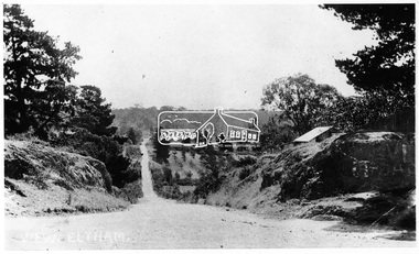 Eltham District Historical Society Inc
Negative - Photograph, View, Bridge Street, Eltham, c.1890
View towards Montmorency Estate from Main Road, Eltham about 1890. Looking down Bridge Street across the bridge (1875). At the corner of Susan Street is the Hill family home. Reproduced in "Montmorency; the farm on the Plenty" by Maureen Jones, 2015, p43 - 'View towards Montmorency Estate from main Road, Eltham, c.1890'This photo forms part of a collection of photographs gathered by the Shire of Eltham for their centenary project book,"Pioneers and Painters: 100 years of the Shire of Eltham" by Alan Marshall (1971). The collection of over 500 images is held in partnership between Eltham District Historical Society and Yarra Plenty Regional Library (Eltham Library) and is now formally known as 'The Shire of Eltham Pioneers Photograph Collection.' It is significant in being the first community sourced collection representing the places and people of the Shire's first one hundred years.Digital image 4 x 5 inch B&W Negshire of eltham pioneers photograph collection, eltham, bridge street, bridge street bridge, hill family home, montmorency, susan street -
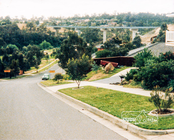 Eltham District Historical Society Inc
Photograph, View looking northwest along Plenty River Drive, Greensborough from outside No. 64, c.1986, 1986c
Shows the eastern bridge of the Greensborough Bypass under construction. Colour photograph originally located in a magnetic style album titled 'Greensborough Bypass 1990s 5' suffering significant degradation. No information contained in album or on reverse of photos except where noted. Relocated to archival photosafe storage.greensborough bypass, road construction, plenty river drive, greensborough