Showing 10987 items matching "land "
-
 Bendigo Historical Society Inc.
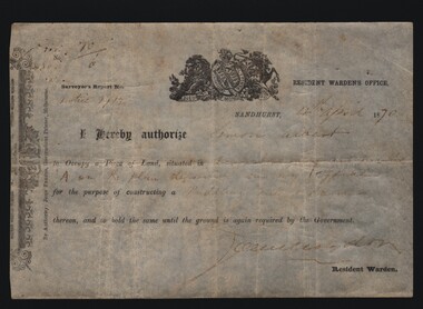
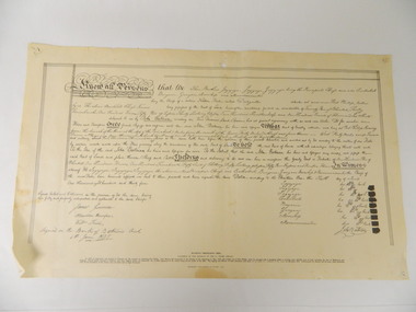
Document - MINERS RIGHT/LAND LEASE, 1870
Document. Miners Right/Land Lease. Paper document dated 4th April 1870 authorizing Simon Albert to construct a puddling mill and dam on land in Devonshire Gully. It reads: I hereby authorize Simon Albert to occupy a piece of land, situated in Devonshire Gully and marked 'A' on the plan deposited in my office for the purpose of constructing a puddling mill and dam, thereon, and to hold the same until the ground is again required by the Government. Printed by John Ferres, Government Printer, Melbourne. Signed by Resident Warden (Signature Unreadable). Lithograph drawings - one of a lion and unicorn with Latin writing.cottage, miners, miners right/land lease, simon albert, devonshire gully, john ferres governmant printer -
 4th/19th Prince of Wales's Light Horse Regiment Unit History Room
Training Pamphlet, The Armoured Personnel Carrier Regiment, 25/10/1984
The aim of this pamphlet is to provide the doctrine for the employment of the Armoured Personnel Carrier Regiment in war. The pamphlet covers the following: a. the role, tasks, characteristics, organisation and responsibilities of key personnel of the armoured personnel carrier regiment, b. command and control within the regiment,and c. the operational employment of the regiment and the techniques it will use at regimental and squadron level. Manual of Land Warfare Part Two- Armour Training Volume 1 - Armour in Battle Pamphlet No 3 7610-66-120-3847 -
Tatura Irrigation & Wartime Camps Museum
Book, Natural Resources and Environment Committee of Cabinet, Salt Action, 1987
Soft cover. Off white background. Dead grey trees, dark green writing, 56 pages.On cover "Government of Victoria / Salt action / Victoria's strategy for managing the / salinity of land and water resources / salt force / draft / February 1987" -
 Beechworth RSL Sub-Branch
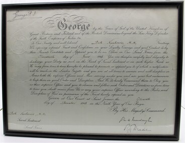
Certifciate
Certificate presented to Dick Nankervis on the occasion of his appointment of an officer in 1918 at Saint James's Court. Refer to Word Document in item 0048Certificate of Appointment in wooden frame with glass frontCertificate appointing Dick Nankervis MM as Officer of the Land Forces by King George VI at the Court of Saint James on 11 December 1918partchment, glass -
 Ringwood and District Historical Society
Photograph, "Quambee" and shed c.1912 before the orchard was planted
Sepia photographWritten on back of photograph: "Quambee and shed before orchard was planted. Coombe's paddock at rear, left of two gumtrees. Arnson's land at rear." -
 City of Kingston
Pamphlet - Colour, Ozone Hill Estate, Cheltenham, 1923
Sales plan for land in the suburb of Cheltenham, along both sides of Victori Avenue, off Weatherall Road.The developing urban area of Cheltenham within the City of Kingston. This land sale pamphlet illustrates the subdivision of land within the municipality and the changing demographic of the district as new houses are constructed.Colour pamphlet advertising for sale the Ozone Hill Estate, Cheltenham. Incorporates a map of the estate on either side of Victor Avenue, off Weatherall Road. Handwritten in blue ink on the subdivision map: 'Sold' is written on subdivisions 1-4, 8, 11, 13, 16-26, 28, 29, 33, 39-41 Handwritten in blue ink on the subdivision map: 'House being erected' is written on subdivisions 22 and 33. Handwrittten in grey pencil adjacent to subdivisions 21 and 22: Tennis / Courts / being / constructed / here Handwritten in grey pencil at bottom of page: Revised to 30/1/24 Handwritten in grey pencil on subdivision map: assumed land sale price is recorded on subdivisions 5-9, 9-10, 12, 14-15, 27, 30-32, 34-38. land sales, cheltenham, estate -
 Kew Historical Society Inc
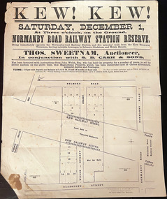
Plan, Kew! Kew!, 1888
The Land Boom of the 1880s accelerated the rate of subdivisions in Kew. This subdivision, 'Kew! Kew!' was also impacted by, or resulted from, the decision by the Victorian Government to construct the Outer Circle railway. Construction of the railway began in 1888 and was completed in 1891. Plan of an 1888 subdivision bounded by Bulleen Road (now High Street), Gladstone Street (now Campbell Street?), Park Street (now Adeney Avenue), and Belmore Road (now Harp Road). The 16 lots in the proposed subdivision are bisected by the route of the Outer Circle railway, and next to the proposed Normanby Station (later renamed East Kew). On the plan, local landmarks such as the tram terminus, the Harp of Erin hotel, and the station are located. The street where the lots are numbered , was called Welsh Street on the plan as this was the name of the vendor. Surrounding land owners are also named: G. Smith Esq, Matthew Maher Esq, and Maurice Neligan Esq.outer circle railway, land subdivisions -
 Wodonga & District Historical Society Inc
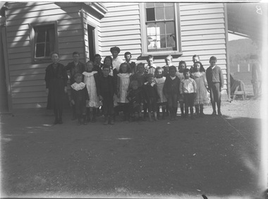
Negative - Haeusler Glass Negatives Collection - Wodonga West Primary School
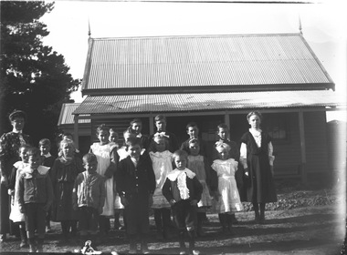
The Wodonga Historical Society Haeusler Collection provides invaluable insight into life in late nineteenth and early twentieth century north east Victoria. The collection comprises manuscripts, personal artefacts used by the Haeusler family on their farm in Wodonga, and a set of glass negatives which offer a unique visual snapshot of the domestic and social lives of the Haeusler family and local Wodonga community. The Haeusler family migrated from Prussia (Germany) to South Australia in the 1840s and 1850s, before purchasing 100 acres of Crown Land made available under the Victorian Lands Act 1862 (also known as ‘Duffy’s Land Act’) in 1866 in what is now Wodonga West. The Haeusler family were one of several German families to migrate from South Australia to Wodonga in the 1860s. This digital image was produced from one of the glass negatives that form part of the collection, probably taken by Louis Haeusler (b.1887) with the photographic equipment in the Wodonga Historical Society Haeusler Collection. This item is unique and has well documented provenance and a known owner. It forms part of a significant and representative historical collection which reflects the local history of Wodonga. It contributes to our understanding of domestic and family life in early twentieth century Wodonga, as well as providing interpretative capacity for themes including local history and social history.Digital image created from the Haeusler Glass negative collection. A group of children and their teacher outside Wodonga West Primary School No. 1058. C.1910. The school was located near the current intersection of McKoy Street and the Hume Freeway in West Wodonga on land donated by J.W. Klinge, replacing an older school north of the railway line. It operated from January 1870 to May 1950 when the nine remaining students transferred to Wodonga Primary School. wodonga pioneers, haeusler family, glass negatives, dry plate photography, wodonga west primary school, schools wodonga -
 Wodonga & District Historical Society Inc
Negative - Haeusler Glass Negatives Collection - Wodonga West School and pupils
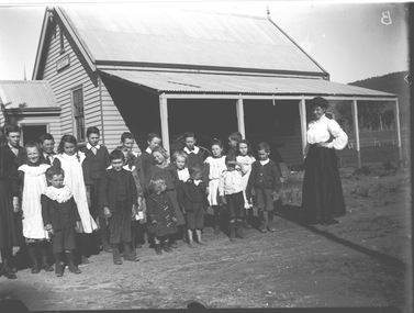
The Wodonga Historical Society Haeusler Collection provides invaluable insight into life in late nineteenth and early twentieth century north east Victoria. The collection comprises manuscripts, personal artefacts used by the Haeusler family on their farm in Wodonga, and a set of glass negatives which offer a unique visual snapshot of the domestic and social lives of the Haeusler family and local Wodonga community. The Haeusler family migrated from Prussia (Germany) to South Australia in the 1840s and 1850s, before purchasing 100 acres of Crown Land made available under the Victorian Lands Act 1862 (also known as ‘Duffy’s Land Act’) in 1866 in what is now Wodonga West. The Haeusler family were one of several German families to migrate from South Australia to Wodonga in the 1860s. This digital image was produced from one of the glass negatives that form part of the collection, probably taken by Louis Haeusler (b.1887) with the photographic equipment in the Wodonga Historical Society Haeusler Collection. This item is unique and has well documented provenance and a known owner. It forms part of a significant and representative historical collection which reflects the local history of Wodonga. It contributes to our understanding of domestic and family life in early twentieth century Wodonga, as well as providing interpretative capacity for themes including local history and social history.Digital image created from the Haeusler Glass negative collection. A group of students and their teacher standing outside Wodonga West Primary School No. 1058. C.1910. The school was located near the current intersection of McKoy Street and the Hume Freeway in West Wodonga on land donated by J.W. Klinge, replacing an older school north of the railway line. It operated from January 1870 to May 1950 when the nine remaining students transferred to Wodonga Primary School.wodonga pioneers, haeusler family, glass negatives, dry plate photography, wodonga west school -
 Wodonga & District Historical Society Inc
Negative - Haeusler Glass Negatives Collection - Teachers and Students Wodonga West Primary School
The Wodonga Historical Society Haeusler Collection provides invaluable insight into life in late nineteenth and early twentieth century north east Victoria. The collection comprises manuscripts, personal artefacts used by the Haeusler family on their farm in Wodonga, and a set of glass negatives which offer a unique visual snapshot of the domestic and social lives of the Haeusler family and local Wodonga community. The Haeusler family migrated from Prussia (Germany) to South Australia in the 1840s and 1850s, before purchasing 100 acres of Crown Land made available under the Victorian Lands Act 1862 (also known as ‘Duffy’s Land Act’) in 1866 in what is now Wodonga West. The Haeusler family were one of several German families to migrate from South Australia to Wodonga in the 1860s. This digital image was produced from one of the glass negatives that form part of the collection, probably taken by Louis Haeusler (b.1887) with the photographic equipment in the Wodonga Historical Society Haeusler Collection. This item is unique and has well documented provenance and a known owner. It forms part of a significant and representative historical collection which reflects the local history of Wodonga. It contributes to our understanding of domestic and family life in early twentieth century Wodonga, as well as providing interpretative capacity for themes including local history and social history.Digital image created from the Haeusler Glass negative collection. A group of students with their teacher standing outside their school building at Wodonga West, Victoria No. 1058. The school was located near the current intersection of McKoy Street and the Hume Freeway in West Wodonga on land donated by J.W. Klinge, replacing an older school north of the railway line. It operated from January 1870 to May 1950 when the nine remaining students transferred to Wodonga Primary School.wodonga pioneers, haeusler family, glass negatives, dry plate photography, wodonga west primary school -
 Bendigo Military Museum
Photograph - PHOTOGRAPH, SANDAKAN WAR CEMETERY, H Eisfelder, 1947
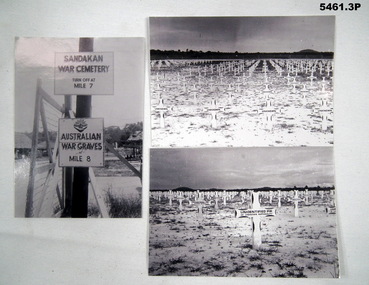
Sandakan- Panali, North Borneo were the places of the infamous Sandakan death march. Thousands of allied POWS died. Aust lost 1787 men. Refer to the Australian War Memorial for details. Three black and white photographs taken just after WW2 .1) Photograph showing two signs, a gate post and barbed wire gate. .2) Photograph of flat land, with an enormous number of white wooden crosses. The crosses in the foreground are marked unknown. .3) photograph of flat land, with numerous white crosses. The foreground ones are marked unidentified P.W of unknown nationality .1) Photograph of signs. “Sandakan War Cemetery Turn off at Mile 7 Other sign “ Australian War graves at Mile 8” Rear has a label. All three- Sandakan (North Bendigo) photo taken early June 1947 by H. Eisfelder. ww2, p.o.w, sandakan -
 Bendigo Historical Society Inc.
Document - H.A. & S.R. WILKINSON COLLECTION: CONTRACT OF SALE
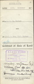
Contract of sale of land dated 11th December, 1954 between Mrs. H.F.M. Warlow (seller) and Mr. E.C. & Mrs. D.J. Rayner for land being Crown allotment 6 section 25 at Eaglehawk described in certificate of title volume 1217 folio 243293, situate in Junction Street Eaglehawk. Together with brick and weatherboard dwelling and all sundry. Price 700 poundsorganization, business, h.a. & s.r wilkinson real estate -
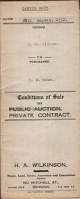 Bendigo Historical Society Inc.
Document - H.A. & S.R. WILKINSON COLLECTION: CONDITION OF SALE
Conditions of sale by private contract dated 29th August, 1932 between J.S. Wilson (seller) and C.W. Rowe (buyer) for land situate No. 91 Booth Street, Golden Square, at present occupied by Mr. Greenway as tenant, being the land described in certificate of registration as residence area No. ? Together with 5 roomed weatherboard dwelling and all sundry. Price 260 pounds.organization, business, h.a. & s.r wilkinson real estate -
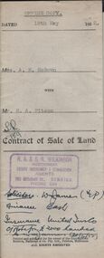 Bendigo Historical Society Inc.
Document - H.A. & S.R WILKINSON COLLECTION: CONDITION OF SALE
Contract of sale of land dated 19th May, 1952 between Mrs. A.M. McGown (seller) and Mr. H.A. Pitson (buyer) for land being Crown allotment 6 section 128C described in certificate of title volume 6410 folio 1281821 situate No. 24 Havelock Street, Bendigo, together with 6-roomed weatherboard dwelling and all sundry. Price 2,800 pounds.organization, business, h.a. & s.r wilkinson real estate -
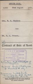 Bendigo Historical Society Inc.
Document - H.A. & S.R. WILKINSON COLLECTION: CONDITION OF SALE
Contract of sale of land dated 22nd August, 1952 between Mrs. M.S. Hindson (seller) and Mr. H. A. Pitson (buyer) for land being allotment 363 section H described in Crown grant volume 864 folio 761 situate No.10 Wolstencroft Street, Bendigo, together with 6-roomed weatherboard and brick dwelling and all sundry. Price 1,700 pounds.organization, business, h.a. & s.r wilkinson real estate -
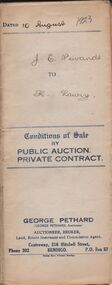 Bendigo Historical Society Inc.
Document - H.A. & S.R. WILKINSON COLLECTION: CONDITION OF SALE
Conditions of sale by private contract issued by George Pethard dated 10th August 1923 between Jane Elizabeth Neivandt (seller) and Kate Lawry (buyer) for land situate in Lilac Street Bendigo between Vertelhausen's and Bowan's residence areas land described in certificate of registration of residence area No. 20225, together with 7-roomed dwelling and all sundry. Price 350 pounds.organization, business, h.a. & s.r wilkinson real estate -
 Bendigo Historical Society Inc.
Administrative record - Land Register
Title on the front says - Bendigo Sec 12, Register. Large land register book. Board cover and back - covered by material of blue silk and leather. Paper on the inside - 101 pages - handwritten. Each page is divided into application numbers, full names, dates of application, parish of address, and details regarding the land and what is being done with it. Dates approx. ~ 1895 - 1949Written on spine - 5 12 1 7 1. Front cover large capital B on the side of the cover and in the middle is Bendigo Sec 12 Register. land register, financial, bendigo -
 Kew Historical Society Inc
Plan - Subdivision Plan, St Helliers Estate, Kew, circa 1910, c.1910
Pru Sanderson, in her groundbreaking ‘City of Kew Urban Conservation Study : Volume 2 - Development History’ (1988), summarised the periods of urban development and subdivisions of land in Kew. The periods that she identified included 1845-1880, 1880-1893, 1893-1921, 1921-1933, 1933-1943, and Post-War Development. These periods were selected as they represented periods of rapid growth or decline in urban development. An obvious starting point for Sanderson’s groupings involved population growth and the associated economic cycles. These cycles also highlighted urban expansion onto land that was predominantly rural, although in other cases it represented the decline and breakup of large estates. A number of the plans in the Kew Historical Society’s collection can also be found in other collections, such as those of the State Library of Victoria and the Boroondara Library Service. A number are however unique to the collection.Subdivision plans are historically important documents used as evidence of the growth of suburbs in Australia. They frequently provide information about when the land was sold on which a built structure was subsequently constructed as well as evidence relating to surveyors and real estate and financial agents. The numerous subdivision plans in the Kew Historical Society's collection represent working documents, ranging from the initial sketches made in planning a subdivision to printed plans on which auctioneers or agents listed the prices for which individual lots were sold. In a number of cases, the reverse of a subdivision plan in the collection includes a photograph of a house that was also for sale by the agent. These photographs provide significant heritage information relating house design and decoration, fencing and household gardens.In the subdivision of part of Crown Portion 82, bordered by John and Sackville Streets and Cotham and Burke Roads, over 100 lots were offered for sale. In addition to the designated lots, a number of key locations are also identified. These include the Genazzano Convent to the north of Cotham Road, the Reservoir, St Hilary’s and the land holding of Colonel Parnell on the corner of John Street and Cotham Road. On the Plan, No. 5064, is the handwritten name ‘St. Hellier’s Estate’. St. Helliers, the home of the Dumaresq family is shown beside St. Hilary’s.subdivision plans - kew, st helliers estate -
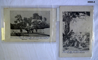 Bendigo Military Museum
Postcard - POSTCARDS WW1, 06.02.1916 (written)
2 x Laminated post cards with black & white images of Holy Land possibly Palestine. .1) Image of the ancient tree. .2) Image of a well..1) On back of card: "Aerodrome Camp Sunday 6.2.16", Top L corner: "My dear Hil" .2) On back of card: "From your loving husband Horace"documents - post cards, military history, passchendaele barracks trust -
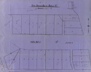 Federation University Historical Collection
Map, Plan subdivision: Allotment 12 Holmes Street, Ballarat
The Allotments drawn in Holmes Street appear to be hand drawn and showing one of the first subdivisions in Ballarat. This was begun in the 1860s. Some names are marked on the blocks - Taylor (9), Holmes (6), Robert Watson (3), Watson (16), Walter (18),Wetherly (11), Vacant (7)Blue paper with black ink showing the land blocks either side of Holmes Street Each block is numbered - 20 in all Names on some blocksNorth indicated with arrow Sizes of blocks - depth and width holmes street, subdivision, allotment 12, holmes, taylor, robert watson, watson, wetherly, vacant -
Glenelg Shire Council Cultural Collection
Photograph, View of Portland Harbour and port, 1960s
Port of Portland Authority archives.Front: (no inscriptions) Back: (no inscriptions)port of portland, lady bay -
Glenelg Shire Council Cultural Collection
Photograph - Photograph- land reclamation, n.d
Port of Portland Authority Archivesport of portland archives, k s anderson wharf, botanic gardens, reclamation, ocean pier -
Glenelg Shire Council Cultural Collection
Photograph - Photograph - Aerial photograph of coastline around Portland Victoria, c. 1954
Black and white aerial photograph of coastline around Portland. Black border, bottom edge, section of larger photo, approximately 50%, only land visible.Front: 'PORTLA' -printed, white border -
 Kiewa Valley Historical Society
Deed, Batman's Melbourne Deed c1835, Original 6 June 1835. Copied 1966
Facsimile of the oriental in the Latrobe Library of the acquisition of 600,000 acres of land (sites of Melbourne & Geelong) between John Batman & Principal chiefs of Dutteallar native tribe.john batman. -
 Ringwood and District Historical Society
Plan, Ringwood Station Estate, Subdivision, Ringwood, Victoria - circa 1925
ID 5224 note: Further information relating to squares marked H, F, G, J, and K included in ID 5225 - Ringwood Shop and Dwelling Estate.Hand drawn plan of Ringwood Station Estate showing allotments for sale, with two typed pages attached showing land title information and sale prices.Drawn by Edyth Greenwood, phone 988 Central. Subdivision includes Station Street, Pitt Street, Bedford Road, Wantirna Road, James Street, William Street (later Kendall Street), Greenwood Avenue, Ellison Street, and Haig Street. Circles denote blocks for sale. Squares denote house properties for sale. Other features marked include location of businesses along Main Street (Maroondah Highway), cool store, railway station, shop and police station on Bedford Road, church on Station Street, site of schoolmaster's residence and State School, and location of proposed public baths. Ryner & Langford, Solicitors -
Glenelg Shire Council Cultural Collection
Photograph - Photograph - Foreshore Development, n.d
Port of Portland Authority ArchivesBack: fd005, bottom right, pencil.port of portland archives, reclamation henty beach, bentinck street -
Glenelg Shire Council Cultural Collection
Photograph - Photograph - tug 'Trewalla', n.d
Port of Portland Authority Archivesport of portland archives, tug boat, trewalla -
Glenelg Shire Council Cultural Collection
Photograph - Photograph - Portland Harbour, Jun-92
Port of Portland Authority ArchivesFront: Back- 6/92-Blue biroport of portland archives, portland maritime discovery museum, land reclamation -
Glenelg Shire Council Cultural Collection
Photograph - Photograph - Portland Harbour, Jun-92
Port of Portland Authority ArchivesFront: Back- 6/92- Blue biroport of portland archives, portland maritime discovery museum, land reclamation, portland harbour -
Glenelg Shire Council Cultural Collection
Photograph - Photograph - Main Breakwater construction, Portland, n.d
Port of Portland Authority ArchivesBack: 4 (in a circle) - pencilport of portland archives, main breakwater, construction, harbour development