Showing 11164 items matching "planning "
-
 Federation University Historical Collection
Plan, Ballarat School of Mines Clay Mill Building Alterations, 1962, 04/10/1962
Two plans for alterations to the Ballarat School of Mines Clay Mill Building to the Fluid Mechanics Labratory. .1) Existing Clay Mill Building .2) Plan and sections of proposed changes to the Clay Mill Building.john e. dixon, clay mill building, ceramics, ballarat school of mines, battery building -
 Port Melbourne Historical & Preservation Society
Book - Community Services Centre, Planning Document, 1992
Community Services Centre. Planning Document 1992. Detailed planning document to co-ordinate community services and, in particular, to meet the changing needs of residents. City of Port Melbourne 1992. Blue front pagelocal government - city of port melbourne -
Port Melbourne Historical & Preservation Society
Plan - Ada Mary A'Beckett Free Kindergarten, Fishermans Bend, Martin & Tribe, Architects, 3 Mar 1947
Martin & Tribe - ArchitectsArchitectural plan for the Ada Mary A'Beckett Free Kindergarten and Infant Welfare Centre, Fishermens Bend, 1947. Floor plan, elevations and cross sections. Set number 1 - two pages stapled together.Drawn by J. C. B.education - kindergartens, garden city, built environment - civic, fishermans bend, ada mary a'beckett, martin & tribe, ada mary a'beckett kindergarten -
Port Melbourne Historical & Preservation Society
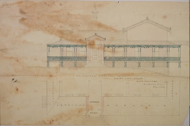
Plan - Proposed Spring Street elevation, Port Melbourne Town Hall, Arthur Victor Heath, Town Clerk, 10 Dec 1907
Plan of proposal for a new Town hall; front elevation Spring Street; cross section; longitudinal section; side elevation; floor plan. Pen drawings tinted (possibly in water colour) dated 1907Stamped "Surveyor's Office, Town of Port Melbourne":Signed "A.V. Heath 10/12/07"port melbourne town hall, arthur victor heath, town clerks -
Tatura Irrigation & Wartime Camps Museum
Book, Department of Agriculture Victoria, Institute for Sustainable Agriculture, 1993
Investigation of salinity problems by staff at Tatura, Kyabram, Shepparton, and Cobram Institutes.Department of Agriculture photos on front. Saline waterlogged land near Shepparton. Measuring white clover growth. Salinity management plans for research. Farm planning blueprint. Satellite image of plains and Lodden river.salinity, department of agriculture, kyabram, tatura, shepparton, cobram -
 Kew Historical Society Inc
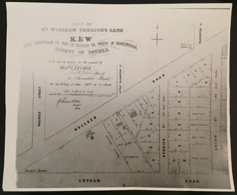
Plan - Framed Subdivision Plan (copy), F Price, Plan of Mr William Derrick's Land, Kew being Subdivision of Part of Section 86, Parish of Boroondara, County of Bourke, 1872, 1872
William Derrick was an early landowner in Kew, and with James Venn Morgan and James Dannock the purchaser of the parcel of land bounded by Cotham Road, High Street and Mary Street. Derrick Street in Kew is named after him.Map mounted under perspex. ‘Plan of Mr Willia Derrick's Land, Kew being Subdivision of Part of Section 86, Parish of Boroondara, County of Bourke’. This is a copy of the plan held in the State Library of Victoria.kew subdivision plan, john derrick, subdivision plans -- kew (vic.) -
University of Melbourne, Burnley Campus Archives
Plan, Burnley Horticultural College Students Amenities Building, 1992
First Floor - SRC Office/Furniture. Changes in plan No C2980 02/03/1972. 1:50. All messurements (sic) in cm. and according to original floor plan! 04/03/1992. johnsdorfer.amenities, students, vcah, burnley, john s dorfer -
University of Melbourne, Burnley Campus Archives
Work on paper (item) - Student Work, Caitlin Taylor, Luminous Landscape Design Documentation Plan, 5th November 2018
Submitted as an assignment for HORT90035, a subject at Burnley Horticultural College coordinated by Andrew Laidlaw. -
 Bendigo Historical Society Inc.
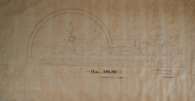
Plan - HORWOOD COLLECTION: DRAWINGS FOR CONSTRUCTION OF 18'' ENGINE
Engineers plan for an 18 '' engine. Written on bottom 'J. Horwood and Sons, Engineers, Sandhurst. 18 IN Engine, Scale one inch = one foot' Plan drawn in fine black pen on waxed paper.bendigo, industry, horwood, foundry, mining equipment -
University of Melbourne, Burnley Campus Archives
Document - Register, University of Melbourne (Burnley Campus)-Grassy Woodland Plant List, c.1990
(1) List of plants established in the grassland (by number but no plan) compiled by Chris Findlay and Phil Tulk (2 copies). (2) Burnley Native Grassland Plant List, numerical order (no plan) and alphabetical order plants, grassland, chris findlay, phil tulk, native grassland -
 Bendigo Historical Society Inc.
Plan - MARKS COLLECTION: PLAN FOR NEW ENTRANCE VESTIBULE TO FORTUNA VILLA FOR GEO. LANSELL ESQ
Fortuna Villa was owned from 1855 to 1871 by Christopher and Theodore Ballerstedt, Australia’s first mining magnates. In 1871 it was purchased by George Lansell (The Quartz King) being one of Australia’s most successful and adventurous nineteenth century gold mine owners and speculators. Lansell made numerous alterations extensions to the building and remained in the Lansell family until 1935plan for new entrance vestibule to Fortuna Villa for George Lansell Esq. coloured plan detailing new entrance vestibule and open recess across the verandah, and entry steps RHS of page damaged/ tornfortuna villa, geo.lansell esq., building plan, c & t ballerstedt -
 Bendigo Historical Society Inc.
Document - HOWARD AND VIOLET JOLLEY COLLECTION: PLANS
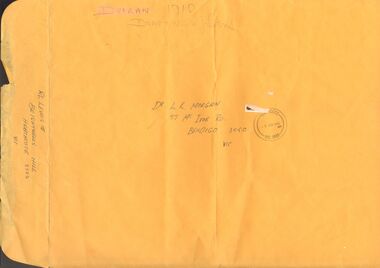
3 pages of plans, drawn in black pen, for replica of John Robinson Duigan's Aircraft, 1919. Plans appear to be copies. A3 Manilla envelope addressed to Dr. L.K. Morgan, 57 McIvor Road, Bendigo contains plans. On rear of envelope: RL Lewis Brightwells Hill, Heathcote, 3523. Front view, side view and plan view written respectively on each plan. On bottom RH of 'Front view' plan is stamp from Civil Aviation Authority Australia , dated 9.12.91. On top RH corner is written ' these drawings are not be be reproduced by anyone other than the builder, Ronald Lloyd Lewis' Items in this collection were donated by Dr. Jan Sherringham, whose husband is a pilot. It can only be assumed that this document belonged to them as it postdates Violet's death.person, bendigo, john robinson duigan, duigan, john robinson, lewis, ronald lloyd, aeroplane, plan -
 University of Melbourne, Burnley Campus Archives
Plan, Orchard/Field Station, 1983 - 1992
(3) Used by Linda Hipwell for her Honours Thesis.Plans of the Orchard later known as the Field Station. (1) Copy, "Drawing: Orchard Site Plan." Each section labelled. (2)Tracing paper, 2 paper copies and 3 enlargements, "VCAH Burnley Field Station Plan," some printed labelling and some in pencil. 1992.(3) "VCAH Burnley Field Station Proposed Redevelopment," drawn by MG July 1992. (4) Tracing paper copy, Site Plan of Orchard by Alexander Metherell Pty. Ltd. Job No BHC/1 drawing No SP/2 Dec 1983. Scale 1:500. (5) Plan on tracing paper, includes Energy Education Centre. (6) Plan on tracing paper, includes Energy Education Centre. Scale 1:500. Also see B15.0352 Full Report. orchard, field station, linda hipwell, alexander metherell -
Whitehorse Historical Society Inc.
Document, 520 Mitcham Road, 2005
Papers relating to objections to development of 520-528 Mitcham Road Mitcham.Papers relating to objections to development of 520-528 Mitcham Road Mitcham. Includes: statement by Neil Edwin Kerby & Margaret Anne Kerby; Title searches for 449 Mitcham Road Mitcham and adjacent properties; plan of 1906 subdivision; ASIC extract of development company organisational details; aerial photos of the area; photographs of nearby properties and of Mitcham Road streetscapes and list of Mitcham objectors. CD copy at NP3771Papers relating to objections to development of 520-528 Mitcham Road Mitcham. mitcham road mitcham, nos. 520-528, kerby, neil edwin, kerby, margaret anne, mitcham road mitcham no. 449, 520 mitcham road pty ltd, listermay nominees pty ltd, land subdivision -
 Kew Historical Society Inc
Plan - Subdivision Plan, Wimba Estate, Kew, c.1925-c.1929, ca. 1925-ca. 1929
Pru Sanderson, in her groundbreaking ‘City of Kew Urban Conservation Study : Volume 2 - Development History’ (1988), summarised the periods of urban development and subdivisions of land in Kew. The periods that she identified included 1845-1880, 1880-1893, 1893-1921, 1921-1933, 1933-1943, and Post-War Development. These periods were selected as they represented periods of rapid growth or decline in urban development. An obvious starting point for Sanderson’s groupings involved population growth and the associated economic cycles. These cycles also highlighted urban expansion onto land that was predominantly rural, although in other cases it represented the decline and breakup of large estates. A number of the plans in the Kew Historical Society’s collection can also be found in other collections, such as those of the State Library of Victoria and the Boroondara Library Service. A number are however unique to the collection.Subdivision plans are historically important documents used as evidence of the growth of suburbs in Australia. They frequently provide information about when the land was sold on which a built structure was subsequently constructed as well as evidence relating to surveyors and real estate and financial agents. The numerous subdivision plans in the Kew Historical Society's collection represent working documents, ranging from the initial sketches made in planning a subdivision to printed plans on which auctioneers or agents listed the prices for which individual lots were sold. In a number of cases, the reverse of a subdivision plan in the collection includes a photograph of a house that was also for sale by the agent. These photographs provide significant heritage information relating house design and decoration, fencing and household gardens.In 1925, the City of Kew called for tenders for the construction of Wimba Avenue, Cadow Street and Lalla Street. Subsequent advertisements for the sale of land in Wimba Avenue continued from 1926 to 1929. The 18 lots (and a further five allotments on the eastern side of the street) offered for sale were unofficially described in the subdivision plan as the ‘Wimba Estate’. These lots began in Park Hill Road and extended almost to Cotham Road. The subdivision took its name from the house ‘Wimba’ in Cotham Road, which may have formed the southern boundary of the subdivision. (Wimba, at 235 Cotham Road was constructed between 1862-70). The Plan highlights the proximity and advantage of ‘electric’ trams in Cotham and Glenferrie Roads, and the Kew and Glenferrie Railway Stations. An oddity in the Plan is the reference to the electric tram terminus at Burke Road, given that the tramline had already been extended to Mont Albert in 1916.wimba estate, subdivision plans - kew, parkhill road – kew (vic.), normanby road – kew (vic.), wimba avenue – kew (vic.) -
Port Melbourne Historical & Preservation Society
Letter - Tom Roper, Minister for Planning and Environment to Evan Walker, Minister for Major Projects re Bayside EES Inquiry, Ewan Ogilvy's Bayside Papers, Box One, 1987 - 1998
Ewan Ogilvy, former Melbourne Councillor and also of Community Services Victoria, Inner Urban Ministerial Advisory Committee and Uniting Church's Centre for Urban Research and Action (CURA), was instrumental in social justice approaches to town planning. He and CURA's Social Justice and the City Project funded Port Melbourne community groups protesting against the SCDC development in 1987. His files were presented to the Society in May 2001 on his preparation for leaving Victoria.From Ewan Ogilvy's chronologically organised 'Bayside Papers' relating to the proposed development of Port Melbourne industrial land in the late 1980s: Ministerial correspondence from Tom Roper, Minister for Planning and Environment to Evan Walker, Minister for Major Projects, related to panel's decision on Bayside EES Inquiry 1997/8, included in bound black fileAll items signed 'Ewan Ogilvy'town planning, town planning - proposals shelved - bayside, public action campaigns, environmental issues, public housing, missions to seamen, ewan ogilvy, centre for urban research and action, sandridge city development comapny, tom roper, evan walker -
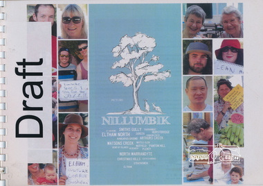 Eltham District Historical Society Inc
Book, Picture Nillumbik, 2012
... planning ...A community-led project to contribute to a vision for the Shire of Nillumbik. Between October 2011 and June 2012, Nillumbik Shire Council undertook a community information gathering project to ask residents "what is your vision for your local community?” Picture Nillumbik represents a collection of responses from community groups, schools and households via online submissions, photos, interviews and workshop contributions. The resulting document provides a snapshot of the values, ambitions and resilience of Nillumbik communities. The project aimed to inform community planning and identify how Council can work better with residents. The resulting document provides a snapshot of the values, ambitions and resilience of Nillumbik communities. Aimed to inform community planning and identify how Council can work better with residents. Further that the document be inspiring, stimulating and a reminder that the future is worth planning for. Includes a number of case studies of local organisations and projects including: Christmas Hills - Butterfly Studios, Strathewen Tree Project, St Andrews mosaic seat, Eltham & District Woodworkers Inc., Edendale Farm - Home harvest, Hurstbridge, Bend of Islands, Bendigo bank, Dunmoochin - Cottles Bridge, Artists Open Studios Program, World Matters and Past Matters, Nillumbik Reconciliation Group, Boots for all. Chapters include: Deep connection and resilient community, local village life, Balance with nature, a sustaining and evolving economy, creative expression, art and cultural exchange, experience discovery and fulfilment and stewarding the Nillumbik way. Each chapter includes further questions for discussion.Spiral bound document printed in landscape format. Includes text and colour photographs. 196 pagesSmall piece of paper headed "DRAFT" included at the front of the document when bound.shire of nillumbik, planning, future, christmas hills, strathewen tree project, st andrews, eltham & district woodworkers inc., edendale farm, bend of islands, dunmoochin, artists open studios program, nillumbik reconciliation group, community groups, vision, strategy -
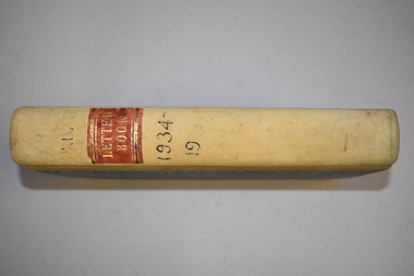 Warrnambool and District Historical Society Inc.
Letter book, J & R Crawley, 1934
This letter book contains letters, sketch maps and plans and dates from1934 to 1936. It originally came from the office of John William Crawley Junior, an engineer, surveyor and architect in private practice in Warrnambool and also the Shire Engineer for the Shire of Warrnambool from 1895 to 1935. His father, brother and son were also engineers and worked in that capacity or as the Shire Secretary for the Shire of Warrnambool, with the Crawley family recording a total of 132 years of service to the Shire. The Shire of Warrnambool existed from 1863 to 1994. The letter book was also used in the private practice of John Crawley’s son, Rolf who was the engineer for the Shire of Warrnambool from 1935 to 1968. The letter book then came into the possession of Michael Hand who took over the private surveying business of Rolf Crawley in Warrnambool. The Warrnambool and District Historical Society acquired the letter book, along with several other Crawley ledgers, from the estate of Michael Hand.This letter book is of considerable significance as it contains letters written by John Crawley and Rolf Crawley who were in an engineering, surveying and architects private practice in Warrnambool over the time covered in the book. It will be very useful to researchers. This is a hard cover book of 1000 pages but only 354 pages have been used. The cover is bound at the corners and on the spine with buff-coloured leather. The book contains an alphabetical index, handwritten letters, sketch maps and plans. ‘Private Letter Book 1934- 19.’ ‘R.L./J. W. Crawley Private’ john william crawley junior, warrnambool, rolf crawley, warrnambool, shire of warrnambool -
Port Melbourne Historical & Preservation Society
Plan, Graeme Bentley Pty Ltd, Port Melbourne Foreshore Landscape Master Plan MP3 (A), February 1993
The Port Melbourne Foreshore Landscape Master Plan was created by Landscape Architectural firm of Graeme Bentley Pty Ltd for the City of Port Melbourne. MP3 (A) portrays the section of foreshore from Dow Street to Pickles Street. The plan proposed street tree planting along Beach Street and development of a park area opposite Johnson Street. The plan was not actioned.built environment - recreational facilities, beach street, port melbourne foreshore -
Port Melbourne Historical & Preservation Society
Plan, Graeme Bentley Pty Ltd, Port Melbourne Foreshore Landscape Master Plan MP1(A), February 1993
The Port Melbourne Foreshore Landscape Master Plan was created by Landscape Architectural firm of Graeme Bentley Pty Ltd for the City of Port Melbourne. MP1(A) portrays the section of foreshore from the former Port Melbourne Railway Station to Bay Street. The plan proposed extensive tree planting including Tasmanian native trees along Station Pier. The plan was not actioned.built environment - recreational facilities, beach street, port melbourne foreshore, station pier -
Federation University Historical Collection
Book, A Descriptive Catalogue of the Minerals in the Museum of the School of Mines, Ballaarat, 1882, 1882
The Museum of the Ballarat School of Mines was established in 1872. The curator in 1882 was Ferdinand M. Krause. Prefatory Notice by James Oddie). The want of a guide through the technical collections of The School Mines has long been felt by visitors and students - a guide , not so much to those who merely 'look' at the various exhibits in the Museum, but an instructor to those who desire to take away with them some practical information on the natural occurrence and economical value of the objects exhibited. This want is being filled by the labour of Mr. Krause, whose first installment - 'A Descriptive Catalogue of the Minerals' - is herewith represented to the visiting public." Introduction to the catalogue: " The collection is still in its early growth, and far from being a complete representation of the Mineral Kingdom; many varieties, species, and even whole groups are absent. This state of incompleteness will, no doubt, be adjusted in the sequence, and progressive lists issued from time to time. 'Ad interin' the present catalogue will, be found useful to students and visitors of the School. As far as practicable, the classifications of the minerals accords with that adopted at the Royal School of Mines, London. The numbers prefixed to the species in the catalogue agree with those on the descriptive labels which accompany each specimen, and also with those attached to the specimens themselves. On the descriptive labels the chemical composition of the minerals is expressed in formulae usually employed in standard mineralogical works. Students who have note paid attention to mineralogical chemistry will note that each dot over a symbol is equivalent to one atom of oxygen, .... A bar through a symbol denotes a double atom of the base, .... " In 1882 the collection was housed in 33 cases. The catalogue outlines the specimen types housed in each case. The classification of minerals accords with that adopted at the Royal School of Mines, London. Leather covered book of 94 pages with gold lettering on the front, including "F.M. Krause". The book includes a plan of the museum layout, plan of the grounds and buildings of the Ballarat School of Mines and a prefatory notice by James Oddie.ballarat school of mines, ballarat school of mines museum, museum, krause, ferdinand krause, fm krause, oddie, james oddie, geology, mineralogy, charles boyd, f.m. krause, minerals, curator -
Glenelg Shire Council Cultural Collection
Plan - S.S Admella Model Plans, n.d
Photocopy of sale/rigging plan of S.S Admella scale 1:48. Photocopy on parchment style paper. Plan used by 'float-a-boat' model markers for the construction of the Admella model acquired by Grant District council.admella, portland lifeboat, 150th anniversary -
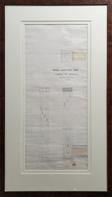 Federation University Historical Collection
Drawing - Architectural Plan, Ballarat School of Mines Gauge Tower Architectural Plan by Henry Richards Caselli, 04/11/1880
The Ballarat School of Mines was the first of its type in Australia. The Albert Street frontage was the 'working end' of the campus with the mining laboratory, gauge tower and caretakers cottage. All the structures in the foreground have been demolished to make way for the Flecknoe Building and the M.B. John Building. The gauge tower is also depicted in the 1881 Annual Report.Original double mounted and framed architectural plan for the Ballarat School of Mines Gauge Tower. The plan includes sections and elecation. Some areas have been coloured, and the drawing is at a scale of four feet to one inch. Verso in ink "Gauge Tower School of Mines" Signed left "H.R. Caselli architect 4.11.80henry caselli, henry richards caselli, architectural plan, ballarat school of mines, gauge tower, buildings, architect -
Port Melbourne Historical & Preservation Society
Map - MMBW, 1897
Melbourne and Metropolitan Board of Works 1895, Plan No. 324, 328, 329 Segments shown: (as plan No's.) Large scale showing hotels, civic and industrial buildings, Graham Street to Bay, Nott and Dow Streets.engineering - board of works, business and traders - hotels, built environment, piers and wharves - town pier, transport - tramways -
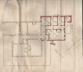 Bendigo Historical Society Inc.
Document - BUSH COLLECTION: PLAN OF HOUSE (FOREST ST, BENDIGO)
Plan of house (Forest St, Bendigo written in pencil on plan) showing what may be extension to original house (in colour and with dimensions). Possibly house of Merle Bush??. Stamp on front: E.?.V. Phone 942.person, individual, bush collection - personal, bendigo, bush collection, collection, house plan, drafting, drawing, plan, house, home -
 Bendigo Historical Society Inc.
Document - MCCOLL, RANKIN AND STANISTREET COLLECTION: NAPOLEON REEF GOLD MINING CO. N.L, 2 May 1940
Document: Prospectus of Napoleon Reef Gold Mining Company, 8 pages plus plan of portion of Napoleon Line of Reefs and plan of transverse section of lease No. 10970, Capital: £30,000 in 60,000 shares of 10/- each.organization, business, industrial - mining, mccoll rankin & stanistreet, mining, gold mining, napoleon reef -
 Bendigo Historical Society Inc.
Document - GERTRUDE PERRY COLLECTION: HOUSE SKETCHES
Two pencil drawings. the first one of the outside of a house and the words; 'This is how your design would look darling". Semi-plan view. "I'd say you are pretty beaut". the second drawing is a plan of the inside.house, private, drawings -
Whitehorse Historical Society Inc.
Letter - Correspondence, Appeal against brothel proposal, 29/08/1985 12:00:00 AM
Letter from Registrar, Planning Appeals Board to Yarramalong Valley Pty Ltd re proposes brothel at Thornton Cres, Mitcham.Letter from Registrar, Planning Appeals Board to Yarramalong Valley Pty Ltd re proposes brothel at Thornton Cres, Mitcham. Also notice of appeal, grounds of appeal and Planning and Appeals Board Act 1980.Letter from Registrar, Planning Appeals Board to Yarramalong Valley Pty Ltd re proposes brothel at Thornton Cres, Mitcham. brothels, yarramalong valley pty ltd, thornton crescent, mitcham, no 25, victoria. planning appeals board, galbally & o'bryan -
 Kew Historical Society Inc
Print - Subdivision Plan, F Price, Plan of Mr William Derrick's Land, Kew being Subdivision of Part of Section 86, Parish of Boroondara, County of Bourke, 1872, 1872 [Original]
This work forms part of the collection assembled by the historian Dorothy Rogers, that was donated to the Kew Historical Society by her son John Rogers in 2015. The manuscripts, photographs, maps, and documents were sourced by her from both family and local collections or produced as references for her print publications. Many were directly used by Rogers in writing ‘Lovely Old Homes of Kew’ (1961) and 'A History of Kew' (1973), or the numerous articles on local history that she produced for suburban newspapers. Most of the photographs in the collection include detailed annotations in her hand.The Rogers Collection provides a comprehensive insight into the working habits of a historian in the 1960s and 1970s. Together it forms the largest privately-donated collection within the archives of the Kew Historical Society.A photographic reproduction of a plan in the Vale Collection of the State Library of Victoria showing William Derricks land in the area bordered by Bulleen Road (High Street); Cotham Road and Union Street. The plan dates from 1872.william derrick, subdivision plans -- kew (vic.) -
University of Melbourne, Burnley Campus Archives
Work on paper (item) - Student Work, Anton Bialylew, Kneebone Project Landscape Design, Uncertain, probably 2017-2018
Made as an assignment for HORT90035, a subject at Burnley Horticultural College coordinated by Andrew Laidlaw.