Showing 110195 items matching "roads"
-
 Eltham District Historical Society Inc
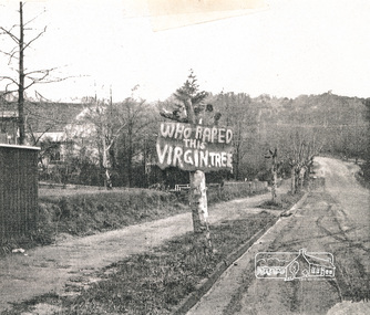
Photograph, Avenue of Honour trees on Main Road below Brougham Street. The sign is indicative of local anger at the pruning, 1969, 1969
... roads ...Avenue of Honour trees on Main Road below Brougham Street, Eltham A sign on a severely pruned tree reads: "Who raped this virgin tree". The sign is indicative of local anger at the pruning, 1969Photocopy of photographeltham, avenue of honour, 1969, brougham street, main road, protests, roads, streets, vandalism, graffiti -
 Ringwood and District Historical Society
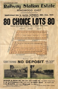
Flyer, Subdivisional Auction Sale Brochure, Railway Station Estate, Ringwood East, Vic. - 1918
Advertisement for subdivisional auction sale of 80 residential allotments on Saturday, 21st December, 1918, including terms of sale, subdivision layout, and nearby location photographs.Subdivision includes Mount Dandenong Road (incorrectly shown as White Horse Road), Dublin Road, Freeman Street, Bona Street, and Patterson Street. Local Agent - J.B. McAlpin, Telephone Ringwood 7. -
 Eltham District Historical Society Inc
Slide, Frank Street, Eltham, Nov. 1981
... roads ...Roll of film taken by Eltham Shire Council officers (Nov. 1981) of the Beard street group, a private street scheme, before construction commenced in February 1982. They provide perspective of the changes in housing styles and road development that began sweeping in from the mid 1970s with increasing urbanisation of what was once more outlying suburbs and regions.35 mm colour positive transparency (1 of 27) Mount - Kodak Ektachrome CardProcessed 18 Jan 1982eltham, housing estate, infrastructure, private street scheme, roads, frank street, foster road, quentin way -
 Eltham District Historical Society Inc
Negative - Photograph, Cottlesbridge-Strathewen Road, Strathewen, c.Nov. 1987
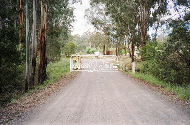
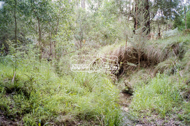
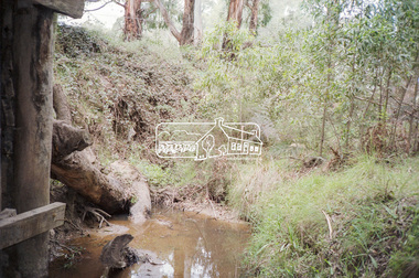
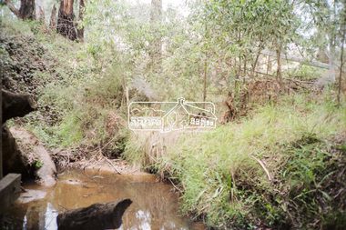
... roads ...Photos taken during a review of road and bridge/culvert condition by Eltham Shire Council engineers. A number of the trees were badly burnt or destroyed in the Black Saturday bushfire, 7 Feb. 2009 but some remained standing and identifiable as of 2014 (Google Streetview).Roll of 35mm colour negative film, 4 stripsKodak GB 200 5096bridge, chads creek, chads creek road, cottlesbridge-strathewen road, culvert, infrastructure, roads, school ridge road, strathewen -
 Eltham District Historical Society Inc
Negative - Photograph, Cottlesbridge-Strathewen Road, Strathewen, c.Nov. 1987
... roads ...Photos taken during a review of road and bridge/culvert condition by Eltham Shire Council engineers. A number of the trees were badly burnt or destroyed in the Black Saturday bushfire, 7 Feb. 2009 but some remained standing and identifiable as of 2014 (Google Streetview).Roll of 35mm colour negative film, 4 stripsKodak GB 200 5096bridge, chads creek, chads creek road, cottlesbridge-strathewen road, culvert, infrastructure, roads, school ridge road, strathewen -
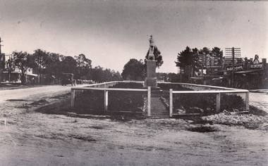 Whitehorse Historical Society Inc.
Photograph - Black and white photograph, War Memorial Mitcham, C1930
Black and white photo of War Memorial in Whitehorse Road,Mitcham.The much travelled (located and relocated) soldier has been placed n many since the end of WW1:|1. Centre of Whitehorse Road within reserve midway between Mitcham Road and Station Street |2. Closer to Mitcham Road and on the garden /lawns between Whitehorse Road (main throughway) and the northern service| road. 3. On his pedestal outside the Memorial Hall on the corner of Whitehorse Road and MacDowall Street.|4. Currently mounted in the gardens of Halliday Park in Mitcham Rd.war memorial mitcham, whitehorse road -
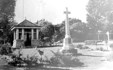 Surrey Hills Historical Society Collection
Photograph, City of Camberwell Council, Surrey Gardens, looking east from Union Road, 1933
The Honor Roll and Shrine in the Surrey Gardens were opened on Sunday 7 April 1918, prior to the cessation of fighting. Mrs Charles H D Steele (MS: Sarah Margaret Russell), president of the local Patriotic League, is credited with the idea of building The Shrine as a fitting memorial to the soldiers of the district. The Surrey Hills Progress Association coordinated raising funds from local residents. John Kendrick Blogg carved the beautiful honor roll in Indian teak and Australian white mahogany and the design of The Shrine was by architectural firm Gawler & Drummond. John Stevens Gawler was a partner in the firm, lived locally and also enlisted. Although he may have been overseas during some of the design process he is often credited with the design. Both men donated their services. The 2 cannons in the gardens were acquired by Mr Arthur Brookes in 1901 to commemorate the end of the Boer War. He was popularly known as 'Empire Brooks' and the cannons as 'Brooks' Babies'. They were originally placed in the grounds of the Guildford Road Recreation Oval. Arthur Brooks was an active community member and one of the founding members of the Surrey Hills Progress Association. Original photo was contained in a booklet printed by Camberwell Council in 1933.This is one of the earliest known photos of 3 elements important in designating the Surrey Gardens as one of the City of Boroondara's heritage gardens, now protected by a heritage overlay. The Shrine was one of the first WW1 memorials to be built in Australia and possibly the first in Victoria. It was unveiled prior to the end of hostilities and was built entirely through local community effort. The design of The Shrine, reflective of domestic architecture, is unusual. Its Honor Roll is also a noted example of sculptor John Kendrick Blogg's work and valued especially for its incorporation of Australian motifs, wattle blossom and gum leaves. The boomerang over the full width of the monument was said to be symbolic of both those who did and did not return. Black and white photo of part of the Surrey Gardens, located between Union Road and Norfolk Road, Surrey Hills. It shows The Shrine, the cannons installed to commemorate the end of the Boer War and the Memorial Cross. Taken from within the park looking east. surrey gardens, shrine of remembrance, monuments and memorials, boer war, mr john kendrick blogg, mr arthur brooks, mrs charles steele, mrs sarah steele, miss sarah margaret russell, cannons, mr john gawler -
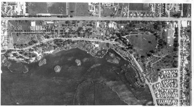 Ballarat Tramway Museum
Photograph - Black & White Photograph/s, early 1980's
Yields information about the Gardens area of Ballarat during the early 1980's.Black and white aerial photograph of the Botanic Gardens and Lake Wendouree adjacent to the Gardens area during the early 1980's. Shows the BTPS depot with 4 and 5 roads track built, but not that of 6 and 7 road. No. 1 road still in position. No. 6 road installed during the 1983-84 year. See 1983-84 Annual Report for construction of 6 road.On rear in pencil "3594/159"trams, tramways, botanical gardens, wendouree parade, lake wendouree, btps depot -
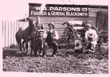 Whitehorse Historical Society Inc.
Photograph - B/W photograph - Copy, William Parsons Farrier
B&W copy showing W Parsons standing, wife Clara and children Joyce and Ray. Situated corner Howletts Road (Blackburn Road) and Tally Ho Road (Highbury Road ) East Burwood. The man seated is the neighbor Mr Clarke who owned the nearby hotel.w a parsons, blacksmith, east burwood -
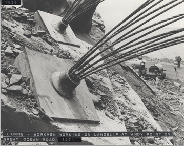 Lorne Historical Society
Photograph, Great Ocean Road. Windy point land slip
1971. This was some of the machinery used in stabilsing the Great Ocean Road between the St George's River and the Sheok River. Holes were drilled in the rock and large cables inserted and concrete forced in around themGreat Ocean Road. This was some of the machinery used in stabilizing the G.O.R. at Windy Point, between the St George River and the Sheoak River. Holes were drilled in the rock and large cables inserted and concrete fixed around them. This took place in late 1971great ocean road. g.o.r. landslip. windy point. 1971 -
 Whitehorse Historical Society Inc.
Leisure object - Land Title, Moffatt land, 1907
Certificate of Title Vol. 3247 Fol. 346.Certificate of Title Vol. 3247 Fol. 346, 9 acres, 25 perches, Mahonys Road Burwood, 19 November 1907. Incl. transfers to MMBW 4 August 1926 and Arthur Vernon Moffatt 30 October 1934 by William James MoffattCertificate of Title Vol. 3247 Fol. 346.moffatt, arthur vernon, melbourne and metropolitan board of works, moffatt, william james, mahoneys road burwood east -
Glenelg Shire Council Cultural Collection
Photograph - Photograph - Dutton Way, 1976
Port of Portland Authority ArchivesBack: Dutton Way - pencil, lines leading to grey stamp. Location Date 30.6.76 - blue biro Time Reference 74/15 - blue biro -
Whitehorse Historical Society Inc.
Map, City of Whitehorse, 1/03/1995 12:00:00 AM
Map showing streets of the City of Whitehorse from Mullum Mullum Creek to the north to Highbury Road and Warrigal Road in the west, to Heatherdale Road in the east.Map showing streets of the City of Whitehorse from Mullum Mullum Creek to the north to Highbury Road and Warrigal Road in the west, to Heatherdale Road in the east. Prep. by Richard Meloni. Scale 1:15,000Map showing streets of the City of Whitehorse from Mullum Mullum Creek to the north to Highbury Road and Warrigal Road in the west, to Heatherdale Road in the east. city of whitehorse, mullum mullum creek -
 Whitehorse Historical Society Inc.
Photograph, Narmara Primary School, 13/01/1994 12:00:00 AM
Coloured photo of Narmara Primary School, Namara Street, looking North. School on North side of Highbury Road, between Middleborough Road and Blackburn Road. Since demolished and site developed for housing.narmara primary school, warner, philip -
 Whitehorse Historical Society Inc.
Photograph, Narmara Primary School, 13/01/1994 12:00:00 AM
Coloured photo of Narmara Primary School, looking West along Highbury Road. School on North side of Highbury Road between Middleborough and Blackburn Roads. Since demolished and site developed for housing.narmara primary school, warner, philip -
 Whitehorse Historical Society Inc.
Photograph - Coloured Photograph, Blackburn Railway Crossing, 2012
See NP3400Coloured photograph of Blackburn Railway crossing on Blackburn Road. South Parade is to the right and Central Road to the left, Blackburn Library is also on the left. The photograph is looking south towards Canterbury Road - 2012blackburn railway crossing, blackburn road -
 Whitehorse Historical Society Inc.
Photograph, Deep Creek Road, Mitcham, 1/01/2001
Black and white photograph of Deep Creek Road, taken from lower entrance of Schwerkolt Cottage Reserve showing Glenvale Road on left. Taken before work started on new bridge and road.deep creek road, mitcham, glenvale road, ringwood -
 Surrey Hills Historical Society Collection
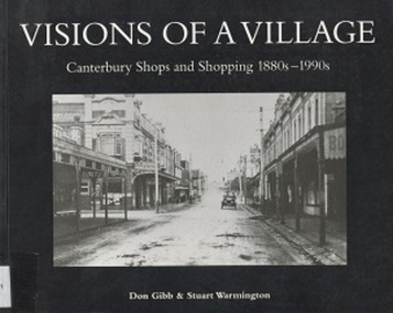
Book, Visions of a Village : Canterbury shops and shopping 1880s-1990s, 1995
Focussing on the growth and activities that took place in the shopping and service centre of Canterbury and Maling Roads in Canterbury from the 1880s to the present, it is partly a guide book to the present buildings of the centre through the streetscapes and brief lives of each of the premises.Focussing on the growth and activities that took place in the shopping and service centre of Canterbury and Maling Roads in Canterbury from the 1880s to the present, it is partly a guide book to the present buildings of the centre through the streetscapes and brief lives of each of the premises. illus. of streetscapes, indexshops, canterbury, maling road, (mr) george robinson, rochester road, j weymouth, railways, m white, hindson buildings, (mrs) - hillier, f g wilson, s huckerby, g cox, (mr) george cornell, lawson brothers, retail trade, commercial development -
 Surrey Hills Historical Society Collection
Book, Visions of a Village : Canterbury shops and shopping 1880s-1990s, 1995
Focussing on the growth and activities that took place in the shopping and service centre of Canterbury and Maling Roads in Canterbury from the 1880s to the present, it is partly a guide book to the present buildings of the centre through the streetscapes and brief lives of each of the premises.Focussing on the growth and activities that took place in the shopping and service centre of Canterbury and Maling Roads in Canterbury from the 1880s to the present, it is partly a guide book to the present buildings of the centre through the streetscapes and brief lives of each of the premises. illus. of streetscapes, indexshops, canterbury, maling road, (mr) george robinson, rochester road, j weymouth, railways, m white, hindson buildings, (mrs) - hillier, f g wilson, s huckerby, g cox, (mr) george cornell, lawson brothers, retail trade, commercial development -
Whitehorse Historical Society Inc.
Article, East Burwood Tram Line, 27/05/1992 12:00:00 AM
The $6.5 million stage 1 extension to East Burwood tramline will start next month.The $6.5 million stage 1 extension to East Burwood tramline will start next month. The extension will be from Middleborough to Blackburn Road and the track construction will begin February 1993. The initial plan is to extend right to Knox City. Construction will be by a combination of VicRoads, MET and private contractors.The $6.5 million stage 1 extension to East Burwood tramline will start next month. tram services, victoria. ministry of transport, vicroads, met, burwood east -
![Map, Plan showing proposed deviation of the road through McKenzie's Flat to Bacchus Marsh. [Undated]](/media/collectors/5e461d8021ea67224c82f2a1/items/677d22f37f2053f3e5d500dc/item-media/677d25247f2053f3e5d50950/item-fit-380x285.jpg) Bacchus Marsh & District Historical Society
Bacchus Marsh & District Historical SocietyMap, Plan showing proposed deviation of the road through McKenzie's Flat to Bacchus Marsh. [Undated]
The date of this map or plan is uncertain. McKenzie's Flat is a bushland picnic area on the Lerderderg River in the Lerderderg State Park close to Bacchus Marsh. The proposed road deviation shown on this map is very close to a sharp bend in the Lerderderg River which shows an island in the centre of that bend. The name of a landholder, J.B. Perry is shown on the map close to the area of the road deviation.The land shown is identified as within the Parish of Merrimu.Single page map showing a proposed deviation of the road from McKenzie's Flat to Bacchus Marsh. Scale: 5 chains to 1 inch. Part of a set of maps which are pasted into a bound volume containing 76 maps or plans in total. High resolution digital image stored on BMDHS computer network. mckenzies flat bacchus marsh, bacchus marsh roads and streets -
 Ballarat Tramway Museum
Photograph - Digital image, Wal Jack, 23/11/1963 12:00:00 AM
Yields information how the body of a former tram was sold and use by the purchaser. Tram body later recovered by the BTM.Digital image from the Wal Jack Ballarat Album of the body after sale of ESCo 22, Sebastopol type car on a farm in Ross Creek Road, photograph on 23/11/1963. Wal Jack Photo. See image i2 for rear of photograph. See image i3 for hi res scan of print. See image i4 for hi res scan of negativeOn rear of photograph in ink "SEC Ballarat / Old No. 22 Sebastopol body in Ross Creek Road, half mile beyond Sebastopol 23/11/63" and W. Jack stamp with number "T1277"trams, tramways, sebastopol type, esco, disposal, sale of trams, tram 22 -
 Glenelg Shire Council Cultural Collection
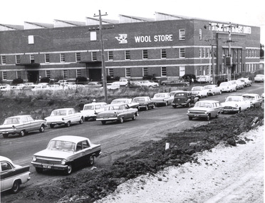
Photograph, Portland Wool Brokers Limited, Wool Store, n.d
Port of Portland AuthorityFront: (no inscriptions) Back: 177 (top right, pencil) -
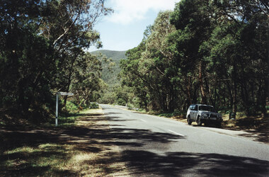 Halls Gap & Grampians Historical Society
Photograph - Coloured, 1998
Photo shows car parked at side of the road at Wannon Campground, looking north on the Halls Gap - Dunkeld Road.access routes, chalets -
Port Melbourne Historical & Preservation Society
Plan - Proposed tramway for Williamstown Road, Port Melbourne, 5 May 1887
Detailed drawings of improved steel tramway broad plate system for ordinary road, proposed for Williamstown Road 1887local government - borough of port melbourne, engineering department - borough of port melbourne -
Tatura Irrigation & Wartime Camps Museum
Photograph, 1989
Camp 1 was occupied by German and Italian internees. Coloured photograph of the entrance to Camp 1. View of camp road with a low stone wall between road and trees.camp 1, tatura victoria, german inernees, italian internees -
Whitehorse Historical Society Inc.
Article, Mirama Court, 1958
A description of the building of 'Mirama Court' on the east corner of Whitehorse Road And Mitcham Road in 1958. also a history of this site.A description of the building of 'Mirama Court' on the east corner of Whitehorse Road And Mitcham Road in 1958. also a history of this site.A description of the building of 'Mirama Court' on the east corner of Whitehorse Road And Mitcham Road in 1958. also a history of this site.shops, mirama court mitcham, mitcham shopping centre, nicholson's milk bar, mirama court fruit palace, blackburn dry cleaning service, margo rae