Showing 28491 items
matching street street
-
 Bendigo Historical Society Inc.
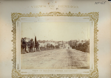
Photograph - VIEWS OF BENDIGO: MITCHELL STREET, SANDHURST, 1875
... VIEWS OF BENDIGO: MITCHELL STREET, SANDHURST...mitchell street...Sepia tones photograph. Streetscape of Mitchell Street... Inc. History House 11 Mackenzie Street Bendigo goldfields ...Sepia tones photograph. Streetscape of Mitchell Street, Sandhurst. Street plantation with protective barricades. Horse drawn vehicle on roadway. Inscriptions: 'Views of Bendigo No. 50'. 'NJ Caire, Photo, Sandhurst', 'Casey & Wenborn" print', 'Forbes and Holmes, Agents', 'Royal Historical Society of Victoria, Bendigo Branch', '1959', '193' in circular stamp on back. Top margin - 'Views of Bendigo, No. 50', Below image - 'View of Mitchell Street, Sandhurst', 'NJ Caire, Photo, Sandhurst', Bottom margin - 'Casey & Wenborn's print, Forbes & Holmes, Agents'. In image ' C H Hoffmeyer', 'Building Materials'. Nicholas CaireN J Caire, Sandhurstplace, streetscape, mitchell street, bendigo -
 Kew Historical Society Inc
Plan, Melbourne & Metropolitan Board of Works : Borough of Kew : Detail Plan No.1576, 1904
... and environmental features. Each plan covers one or two street blocks... Road, Charles Street, Wellington Street and Gellibrand; just... features. Each plan covers one or two street blocks (roughly six ...The Melbourne and Metropolitan Board of Works (MMBW) plans were produced from the 1890s to the 1950s. They were crucial to the design and development of Melbourne's sewerage and drainage system. The plans, at a scale of 40 feet to 1 inch (1:480), provide a detailed historical record of Melbourne streetscapes and environmental features. Each plan covers one or two street blocks (roughly six streets), showing details of buildings, including garden layouts and ownership boundaries, and features such as laneways, drains, bridges, parks, municipal boundaries and other prominent landmarks as they existed at the time each plan was produced. (Source: State Library of Victoria)This plan forms part of a large group of MMBW plans and maps that was donated to the Society by the Mr Poulter, City Engineer of the City of Kew in 1989. Within this collection, thirty-five hand-coloured plans, backed with linen, are of statewide significance as they include annotations that provide details of construction materials used in buildings in the first decade of the 20th century as well as additional information about land ownership and usage. The copies in the Public Record Office Victoria and the State Library of Victoria are monochrome versions which do not denote building materials so that the maps in this collection are invaluable and unique tools for researchers and heritage consultants. A number of the plans are not held in the collection of the State Library of Victoria so they have the additional attribute of rarity.Original survey plan, issued by the MMBW to a contractor with responsibility for constructing sewers in the area identified on the plan within the Borough of Kew. The plan was at some stage hand-coloured, possibly by the contractor, but more likely by officers working in the Engineering Department of the Borough and later Town, then City of Kew. The hand-coloured sections of buildings on the plan were used to denote masonry or brick constructions (pink), weatherboard constructions (yellow), and public buildings (grey). Development in the 20th century has irreparably altered that part of Kew represented in this plan. In the block bounded by Cotham Road, Charles Street, Wellington Street and Gellibrand; just one house standing in 1903 remains. This block included two of the most historic houses in Kew: ‘Ordsall’ (later ‘Southesk’) and ‘Madford’ (previously ‘Elm Lodge’). Ordsall was the home of the second chairman of Kew, John Halfey. It contained some of the most significant interior murals in Kew, created for Halfey by artists working for Cullen & Co. It was demolished in 1960 to make way for the Kew Civic Centre. Elm Lodge had been built for William Siddeley in ca. 1864. Arthur Septimus King purchased it in 1874. The lower paddocks of Madford were sold in 1905 by his wife to the Borough of Kew and, after landscaping by George and Thomas Pockett, opened as the Alexandra Gardens in 1908. Elm Lodge/Madford was in 1922 to become St. Anthony’s Home for Little Children before its subsequent demolition in the 1980s.melbourne and metropolitan board of works, detail plans, maps - borough of kew, mmbw 1576, cartography -
 Port Melbourne Historical & Preservation Society
Photograph - The Official Opening of Rothman's tobacco products new Victorian Distribution Centre 1963, Laurie RICHARDS, 7 Feb 1963
... in Port Melbourne situated on Lorimer Street near Ingles Street... Melbourne Town Hall 333 Bay Street Port Melbourne melbourne ...Photograph of L - R unknown, Cr Mel FENNELL, Cr Les TURNER, Deputy Chairman of Rothmans of Pall Mall, Sir Kenneth COLE, at the Official Opening of' the company's Victorian Distribution Centre in Port Melbourne situated on Lorimer Street near Ingles Street Fishermen's Bend.B & W photograph of two City of Port Melbourne Councillors & the Chairman of Rothmans of Pall Mall (Australia) Ltd.On reverse pasted label with printed Compliments of Rothmans Of Pall Mall typed inscription : On the occasion of the Official Opening of the Rothmans new Victorian Distribution Centre on 7th February 1963. Handwritten - from Right to Left , ? , Cr Mel FERRELL, Cr Les TURNER, Sir Kenneth COLE (Deputy Chairman)leslie stanley turner, local government - city of port melbourne, rothmans of pall mall distribution centre, henry melville fennell, sir kenneth cole, built environment - commercial -
 Federation University Historical Collection
Notebook, Alex Ball, Notes of Lessons, 1964
... pleasant street state school... the Wendouree state school, Wendouree west state school, Pleasant street... school pleasant street state school macarthur street rural school ...Alex Ball attended the Ballarat Teachers' College This notebook contains details regarding Alex Ball's teaching rounds at the following schools around Ballarat. They were the Wendouree state school, Wendouree west state school, Pleasant street state school, Macarthur street rural school, and Alfredton state school.Included throughout the notebook are various handwritten images which were noted as a copy of that day's lesson taken off the blackboard.They were kept in place with metal holders. The registration no. "11733" is included on the front page in pencil.alex ball, lesson plan, notebook, wendouree state school, wendouree west state school, pleasant street state school, macarthur street rural school, alfredton state school -
 Whitehorse Historical Society Inc.
Functional object - Stamp, >1945
... Street (cnr of Harrison Street), Mitcham. Closed in early 2014.... McDowall Street (cnr of Harrison Street), Mitcham. Closed in early ...From the Returned Services League - Mitcham Sub-Branch. Commonly referred to as the|Mitcham R.S.L.|Branch at 26 McDowall Street (cnr of Harrison Street), Mitcham. Closed in early 2014.R.S.L. Mitcham, Ink Stamp, reading |Building Patriot Fund Trust Returned Soldiers League Mitcham Sub-Branc |Brown wood oblong block with painted black handle and blue inked rubber wording.Building Patriot Fund Trust|Returned Soldiers League|Mitcham Sub-Branchmilitary history, air force, army, marines, navy, societies, service clubs -
 City of Ballarat Libraries
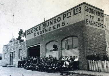
Photograph - Card Box Photographs, George Munro Pty Ltd Engineers, Ballarat circa 1935
... The engineering works was located on Davey Street between...City of Ballarat Libraries Eureka Centre Eureka Street ...The engineering works was located on Davey Street between Mair & Webster Streets. This was later to become Deutcher's, manufacturers of agricultural implements. About 50 employees sit out the front of the building.george munro pty ltd engineers, george munro, building, manufacturing, persons, work -
![Painting: Park Street [Adeney Avenue] Kew](/media/collectors/550653872162f11fb04854aa/items/5826877cd0cdd11284ad5413/item-media/614ac683a53a0756fd5e49da/item-fit-380x285.jpg) Kew Historical Society Inc
Kew Historical Society IncPainting, Park Street [Adeney Avenue] Kew, c. 1896
... Park Street [Adeney Avenue] Kew...park street (kew)... gazetted as ‘Park Street’ (1865) and ‘Park Street South’ (1875... gazetted as ‘Park Street’ (1865) and ‘Park Street South’ (1875 ...‘Adeney Avenue’ was the title given to this painting following its donation to the Kew Historical Society, yet the work’s origins predate the naming of Adeney Avenue in 1907 [originally gazetted as ‘Park Street’ (1865) and ‘Park Street South’ (1875).] Park Street ran between High Street and Parkhill Road beside what was later to become ‘Victoria Park’. This area was described in 1851 as “…a dense forest of gums and wattles which were to be largely cleared by 1888 after the naming of a recreation reserve”. The Reserve was still bisected by an unnamed creek in 1896, when the area was surveyed by the MMBW. The panoramic vista selected by the artist would appear to include ‘Eborensis’ (c.1895) on the corner of Parkhill Road and what was then Park Street, with views across cleared land towards the distant ranges. In the 19th century, north Kew was largely undeveloped farms stretching down to the Yarra. Oil on canvas by an unidentified artist of a panoramic view depicting what is now known as East Kew with mountains on the horizon. In the foreground is a two storey brick residence - Eborensis - located on the northeast corner of Parkhill Road and what is now Adeney Avenue. The view of the landscape and its rolling hills resulted from farming practices adopted following colonisation and settlement. Trees in the foreground and in the distance include remnant Eucalypts and introduced exotics.Label on rear of frame states "House on corner of Adeney Ave & Parkhill. [Regd. 254"]. Otherwise unsigned and undatedadeney avenue (kew), eborensis, park street (kew) -
 Bendigo Historical Society Inc.
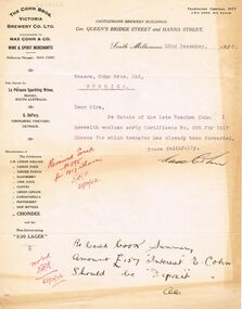
Document - COHN BROTHERS COLLECTION: TYPED LETTER DATED 1922
... Queens Bridge Street and Hanna Street, South Melbourne dated 22nd... Inc. History House 11 Mackenzie Street Bendigo goldfields ...Typed correspondence from Max Cohn on printed Letterhead paper 'The Cohn Bros Victoria Co Ltd successors to Max Cohn & Co Wine & Spirit Merchants Castlemaine Brewery Buildings, cnr Queens Bridge Street and Hanna Street, South Melbourne dated 22nd December 1922. Estate of the late Roschen Cohn share scrip and transfer. Signed Max Cohn.bendigo, industry, cohn bros brewery, max cohn. roschen cohn. cohn share scrip -
 Bendigo Historical Society Inc.
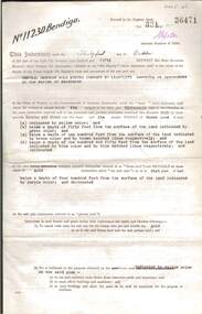
Document - MCCOLL, RANKIN AND STANISTREET COLLECTION: CENTRAL DEBORAH GOLD MINING COMPANY N/L GOLD MINING LEASE, 31 October 1950
... from Breen Street to Victoria Street following the line of Old... Inc. History House 11 Mackenzie Street Bendigo goldfields ...Document: Central Deborah Gold Mining Company N/L gold mining lease. 4 page document with attached map. Map shows area from Breen Street to Victoria Street following the line of Old Violet Street.. Lease between Central Deborah Gold Mining Company N/L and the State of Victoria. No. 11230, Vol 331 Fol 36471.organization, mining, gold mining lease, central deborah gold mining company n/l; gold mining lease -
 Whitehorse Historical Society Inc.
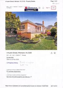
Document - Various including maps, titles, posters, Land ownership of 4 Austin Street, Mitcham, 1873 - 2019
... Land ownership of 4 Austin Street, Mitcham...Austin Street Mitcham No4...Ownership history of 4 Austin Street, Mitcham between 1873... Austin Street Mitcham No4 Ainger Frank Ownership history of 4 ...Ownership history of 4 Austin Street, Mitcham.Ownership history of 4 Austin Street, Mitcham between 1873 to 2019, including the plan of the Mellorton Estate, Mitcham (1923), showing some lots priced at one hundred and forty-five pounds and the Charlesworth Estate ((1913). The Austin Street house was purchased by Martin and Shirley Gleeson 1956 and sold in 2019. Subdivision map of area south of Burnett Street to Harrison Street. non-fictionOwnership history of 4 Austin Street, Mitcham.drake real estate, charlesworth estate mitcham, mellorton estate mitcham, austin street mitcham no4, ainger frank -
 Ringwood and District Historical Society
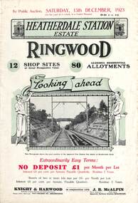
Flyer, Subdivisional Land Auction Sale Brochures, Heatherdale Station Estate, Ringwood, Vic. - 1923 and 1924
... Subdivision includes Heatherdale Road, Molan Street... Road, Molan Street, Yallourn Parade, Newman Street, and Madden ...Two double sided multi-folded pages advertising public auction sales of shop sites and residential allotments on Saturday, 15th December, 1923 and Saturday, 2nd February, 1924, including summary of local facilities, services and map showing layout of the estate. Includes a photograph depicting proposed site for first Heatherdale railway station and a panoramic view of Ringwood from the railway level crossing in Heatherdale Road. 1923 and 1924 flyers are identical except for the auction dates printed at the top.Subdivision includes Heatherdale Road, Molan Street, Yallourn Parade, Newman Street, and Madden Street. Agents - Knight & Harwood, 315 Collins Street, Melbourne, Phone 10615, 10616 Central, in conjunction with J.B. McAlpin, Opposite Railway Station, Ringwood. Phone Ringwood 7. -
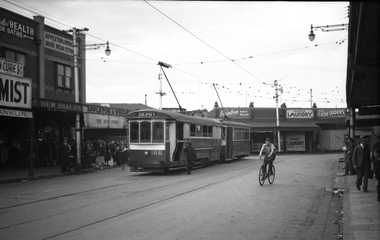
 Ballarat Tramway Museum
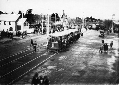
Photograph - Geelong football trams, c1920's
... "21 / Geelong Trmys" "Ryrie Street East / Garden Street... tram 12 "21 / Geelong Trmys" "Ryrie Street East / Garden ...Photograph of Geelong No. 12 towing a trailer with other trams in the background, following a football match, Corio football ground, Ryrie St East, with the Garden St junction in the background. See btm9211 for another print, Dave O'Neil advised 20/7/2009 - Geelong High School to the left and other photos in the series. Laminated A3 size print added 3-08-2014 - to be used for display purposes.Yields information about the form and style of the Geelong tram depot during the Second World War era.Black and white photograph, printed onto card (inkjet printer?) "21 / Geelong Trmys" "Ryrie Street East / Garden Street Jtn in background, / Spectators returning from a Victoria Football League football match, played at Corio Oval, early 1920's" and a "William F Scott" address labels in the bottom right hand corner.trams, tramways, geelong, football, ryrie st, tram 12 -
 Victoria Police Museum
Police Stations (Ararat)
... by Ligar Street, Barkley Street, Ingor Street and High Street...Victoria Police Museum 313 Spencer Street Docklands ...Ararat is a city in south-west Victoria, Australia, about 198 kilometres west of Melbourne, on the Western Highway on the eastern slopes of the Ararat Hills and Cemetery Creek valley between Victoria's Western District and the Wimmera. It is named after Mount Ararat 10 kilometres south-west of the town. A police station opened in Ararat in 1859, though there was a police presence in the area formerly known as Cathcart, Canton Lead and later Mount Ararat. In 1861 staff consisted of 1 Superintendent, 2 Mounted Constables, 1 Sergeant 2nd class, 1 Senior Constable, 8 Constables. The police reserve was on land bounded by Ligar Street, Barkley Street, Ingor Street and High Street. In 1930 the police station was described as a six-room brick dwelling with a slate roof, situated on one quarter acre of land. There was also a bathroom, wash-house, pantry, office, muster room and quarters for a single constable, stables with three stalls, and a lock-up consisting of two six-person cells. Later residences were located at 3 Ligar Street (brick veneer with a tile roof); 32A High Street (brick veneer with tile roof); and 3 Tobin Street (wood with an iron roof). A new, purpose built police station was opened in October 2010 at 77 Barkly Street. The Ararat Police District was reformed into the Wimmera Police District in 1870. Ararat Police Station became part of "R" (Glenelg) District in January 1948 and "M" (Highlands/Wimmera) District from March 1990. A list of police stationed at Ararat from 1903 - 1930 is available from the Victoria Police Museum8 photos comprising: 7 black & white photos 1 colour photopolice stations; ararat police station -
 Clunes Museum
Photograph, CIRCA 1862
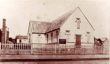
... . PAULS CHURCH OF ENGLAND CLUNES 1862 MOVED FROM FRASER STREET.... PAULS CHURCH OF ENGLAND CLUNES 1862 MOVED FROM FRASER STREET ...ORIGINAL PHOTOGRAPH OWNED BY MRS. ISOBEL FOX. ORIGINAL ST. PAULS CHURCH OF ENGLAND CLUNES 1862 MOVED FROM FRASER STREET CLUNES TO TEMPLETON STREET , AND IS NOW THE CHURCH HALL.SEPIA COPY OF PHOTOGRAPH OF ST. PAULS CHURCH OF ENGLAND. ORIGINAL ST. PAUL'S CHURCH OF ENGLAND 1862.local history, photography, photographs, churches st.pauls anglican -
 Federation University Historical Collection
Photograph, Ballarat Looking Towards the Wesleyan Church
... lydiard street wesleyan church...Panoramic view of Lydiard Street South in Ballarat from...Dana Street, Ballarat, Victoria, Australia... street wesleyan church c.smith nursery Panoramic view of Lydiard ...Panoramic view of Lydiard Street South in Ballarat from the intersection of Lydiard Street and Dana Street. The view shows the former Ballarat Supreme Court (later the Ballarat School of Mines), the Lydiard Street Wesleyan Church (later the Ballarat School of Mines Museum), the site of the Ballarat School of Mines Botanical Gardens, George Smith's Nursery, Ballarat Gaol. Details of the image are also depicted.ballarat school of mines, ballarat gaol, ballarat school of mines museum, ballarat school of mines botanical gardens, george smith, museum, ballarat wesleyan church, ballarat methodist church, lydiard street wesleyan church, c.smith nursery -
Port Melbourne Historical & Preservation Society
Photograph - Foundation stone and plaque, Victorian Seamen's Institute, Beach Street, Port Melbourne, 1888
... , Beach Street, Port Melbourne... corner Nott and Beach Street (Fox Hay building today... Melbourne Town Hall 333 Bay Street Port Melbourne melbourne During ...During demolition of the 1937 Missions to Seamen building in October 1995, this stone was removed intact by developers Mirvac Victoria, and place in the care of the PMH&PS. It is now located as part of the seawall around the car park in front of Nott St. There is a photo of the item on the database, taken in the 1990s while the stone was stored at St Joseph's school in Stokes St.Two photographs taken September 2015 by member Bob Gooding .02 The foundation stone .03 the accompanying plaque - Cornerstone 1888, originally laid at the Victorian Seamen's Institute corner Nott and Beach Street (Fox Hay building today). Was relocated to interior wall near the chapel doors when the new Mission building at corner of Beach Street and Swallow Street was built in 1937.Engraved in gold lettering on a black background: This memorial stone was laid by His Excellenvy Sir Henry B Loch GGMGKCB, Governor of Victoria on Wednesday the 5th day of September AD 1888missions to seamen, sir henry b loch -
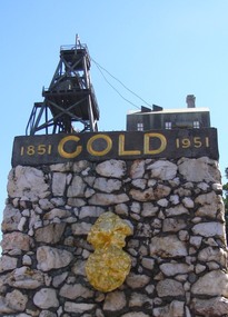 Ballarat Heritage Services
Photograph, Dorothy Wickham, Gold Monument, Ballarat, c2010
... Street. ... of Sturt Street and Albert Street, Ballarat. It commemorates...Sturt Street, Ballarat, Victoria, Australia... in the kitchen of his home at 14 Frank Street. gold monument ballarat ...Gold was discovered in Ballarat in 1851 when many people rushed to the diggings. A monument commemorates the centenary of the finding of gold at Poverty Point and is dedicated to the memory of pioneer miners of Ballarat. It records gold yields, nuggets and the richest recorded yields of both alluvial and quartz mines. The replica gold nugget on the monument is the `Welcome Nugget`, found in Ballarat in 1858, weighed 2,217 ounces and was sold for £10,500. The memorial, known as the Pioneer Miners’ Monument, was made to commemorate Ballarat's gold centenary. It was proposed that part of the Pioneers' Memorial Fund might be used. This fund was started with £1300 profit from the 1938 centenary celebrations. (Age (Melbourne), The monument was created by John Edward Skilbeck, a toolmaker with Ronaldson and Tippett. John Skilbeck had a deep interest in Ballarat History, and undertook much research with Bert Strange and Keith Stacpoole. Councilllor William Ernest Roff provided the copper for the memorial from scrap copper obtained during his plumbing business. The copper was reworked by John Skilbeck, and was soldered in the kitchen of his home at 14 Frank Street. Colour photograph of the gold monument on the corner of Sturt Street and Albert Street, Ballarat. It commemorates the discovery of gold at Poverty Point in August 1851, and was The monument was unveiled in 1951 and is mainly constructed of large piecesof quartz, with a miniature popper head on the top made of copper. Mounted on the side is a replica of the Welcome Nugget, which was unearthed on the corner of Humffray and Mair Streets, Ballarat on 09 June 1858.FRONT This monument was erected by the Ballarat Historical Society to commemorate the finding of gold at Poverty Point 21st August 1851 and is dedicated to the memory of/ pioneer miners of Ballarat LEFT SIDE Richest recorded yields alluvial mines Band of Hope 303269 Ozs Prince of Wales 168929 Koh I Noor 164157 Great Redan Ex 110111 Albion 107125 Bonshaw Fr 96520 Park 94699 St George 86702 Sir Wm Don 76830 Hand in Hand 76830 Sir Henry Loch 43562 Quartz Mines Star of the East 256758 Ozs Band of Hope 158299 Victoria United 152013 N Woah Hawp 129562 New Normanby 127562 Britannia 103225 Llanberris No 1 100533 Black Hill 91665 Last Chance U 83766 Llanberris 71364 Speedwell 66000 South Star 64444 Sulieman Pasha Companies 62666 RIGHT Recorded gold yield 20606000 ozs Nuggets Alluvial Welcome 2217 ozs Saraha Snads 1619 Lady Hotham 1177 Canadian 1 1117 Canadian 2 1011 Koh 1 Noor 834 Eureka 625 Lady Loch 617 Prince of Wales 606 Bakery Hill 571 Native Youth 540 Faboulous yields of earliest diggings not offically recorded Quartz Nuggets N Woah Hawp 5-- 300 200 Ozs White Horse 500 Woah Hawp 444 266 262 Canton 257 200 Q Victoria lease 410 U Black Hill Coy 315 Tinworths 250 Parade Coy 245gold monument, ballarat, skilbeck, poppet head, j.e. skilbeck, john skilbeck -
 Kew Historical Society Inc
Plan - Subdivision Plan, Kewdene Estate, 1937-1939
... giles street -- kew east (vic.)... by Belmore Road, Birtles Street and Giles Street. On the other side... -- kew east (vic.) giles street -- kew east (vic ...Pru Sanderson, in her groundbreaking ‘City of Kew Urban Conservation Study : Volume 2 - Development History’ (1988), summarised the periods of urban development and subdivisions of land in Kew. The periods that she identified included 1845-1880, 1880-1893, 1893-1921, 1921-1933, 1933-1943, and Post-War Development. These periods were selected as they represented periods of rapid growth or decline in urban development. An obvious starting point for Sanderson’s groupings involved population growth and the associated economic cycles. These cycles also highlighted urban expansion onto land that was predominantly rural, although in other cases it represented the decline and breakup of large estates. A number of the plans in the Kew Historical Society’s collection can also be found in other collections, such as those of the State Library of Victoria and the Boroondara Library Service. A number are however unique to the collection.The Kew Historical Society collection includes almost 100 subdivision plans pertaining to suburbs of the City of Melbourne. Most of these are of Kew, Kew East or Studley Park, although a smaller number are plans of Camberwell, Deepdene, Balwyn and Hawthorn. It is believed that the majority of the plans were gifted to the Society by persons connected with the real estate firm - J. R. Mathers & McMillan, 136 Cotham Road, Kew. The Plans in the collection are rarely in pristine form, being working plans on which the agent would write notes and record lots sold and the prices of these. The subdivision plans are historically significant examples of the growth of urban Melbourne from the beginning of the 20th Century up until the 1980s. A number of the plans are double-sided and often include a photograph on the reverse. The advertisement for the ‘Kewdene Estate’ subdivision is pasted over a photograph of a property for sale. This is typical of the reuse of promotional materials in the period during, and subsequent to World War I. The subdivision included 14 lots bordered by Belmore Road, Birtles Street and Giles Street. On the other side of the subdivision [Glass] Creek is noted. The subdivision plan also shows part of the Outer Circle Railway and Deepdene Railway Station.subdivision plans - east kew, kewdene estate, belmore road -- kew east (vic.), giles street -- kew east (vic.) -
 Melbourne Tram Museum
Negative, Wal Jack, c1946
... (Destination, Depot) and an a X2 class in Leeds Street before Irving... (Destination, Depot) and an a X2 class in Leeds Street before Irving ...Black and white negative, by Wal Jack, of S class 166 (Destination, Depot) and an a X2 class in Leeds Street before Irving Street at the Footscray railway station. Photo may be taken on the same day as the other photos of S 166 - 21-4-1945 In the background are View Bakery, Appleton and Wright - Men's Wear, Rainbow Knit Wear, Marx's Laundry and at least one solider.trams, tramways, footscray, s class, leeds st, tram 166, x2 class., mmtb -
 Kew Historical Society Inc
Plan, Melbourne & Metropolitan Board of Works : Borough of Kew : Detail Plan No.1563, 1905
... and environmental features. Each plan covers one or two street blocks...). This plan covers the area between Barkers Road, Wrixon Street... features. Each plan covers one or two street blocks (roughly six ...The Melbourne and Metropolitan Board of Works (MMBW) plans were produced from the 1890s to the 1950s. They were crucial to the design and development of Melbourne's sewerage and drainage system. The plans, at a scale of 40 feet to 1 inch (1:480), provide a detailed historical record of Melbourne streetscapes and environmental features. Each plan covers one or two street blocks (roughly six streets), showing details of buildings, including garden layouts and ownership boundaries, and features such as laneways, drains, bridges, parks, municipal boundaries and other prominent landmarks as they existed at the time each plan was produced. (Source: State Library of Victoria)This plan forms part of a large group of MMBW plans and maps that was donated to the Society by the Mr Poulter, City Engineer of the City of Kew in 1989. Within this collection, thirty-five hand-coloured plans, backed with linen, are of statewide significance as they include annotations that provide details of construction materials used in buildings in the first decade of the 20th century as well as additional information about land ownership and usage. The copies in the Public Record Office Victoria and the State Library of Victoria are monochrome versions which do not denote building materials so that the maps in this collection are invaluable and unique tools for researchers and heritage consultants. A number of the plans are not held in the collection of the State Library of Victoria so they have the additional attribute of rarity.Original survey plan, issued by the MMBW to a contractor with responsibility for constructing sewers in the area identified on the plan within the Borough of Kew. The plan was at some stage hand-coloured, possibly by the contractor, but more likely by officers working in the Engineering Department of the Borough and later Town, then City of Kew. The hand-coloured sections of buildings on the plan were used to denote masonry or brick constructions (pink), weatherboard constructions (yellow), and public buildings (grey). This plan covers the area between Barkers Road, Wrixon Street, Sackville Street and Brougham Place, much of it now occupied by Carey Baptist Grammar and Preshil schools. This was an area of large and prestigious homes in 1903, some with formally laid-out gardens, such as ‘Tower Hill’ and ‘Opawa’. ‘Kalimna’ was built in 1890-91 for William H. Jarman, an accountant, and ‘Blackhall’ at the same time for W.H. Roberts. Blackhall was to be acquired by the Salvation Army in 1915 and renamed ‘Catherine Booth Girls’ Home’. The Home accommodated girls, aged between 4 and 16. Kalimna and Blackhall are of significance as typical and intact late Victorian mansions and as such are two key Victorian buildings to have been built in Kew. Both Blackhall and Kalimna are now part of Preshil. ‘Fairview’ was for a long time occupied by the Sisters of St. Joseph of Cluny as a care home for the elderly, but it is now part of Carey Grammar School, as are the grounds of ‘Wagga Merne’, ‘Weemutta’, ‘Blakely’, ‘Daheim’ and ‘Mildura’ (later ‘Urangeline’), the last being particularly impressive in 1903, with a tennis court, conservatory, outhouses, and two bathrooms!melbourne and metropolitan board of works, detail plans, mmbw 1563, cartography -
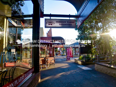
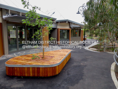 Eltham District Historical Society Inc
Photograph - Digital Photograph, Jim Connor, Eltham Town Square, Commercial Place, Eltham, 2 November 2015
... running between Arthur Street and Pryor Street. Its origins... running between Arthur Street and Pryor Street. Its origins ...Eltham Town Square is centred along Commercial Place running between Arthur Street and Pryor Street. Its origins stretch back to the first design proposals developed in 1979 by then Shire Planner Rodney Roscholler who later went on to become Eltham Shire Council CEO, and Cr. Robert Allenjim connor collection, commercial place, eltham shopping centre, eltham town square, small plates -
 Eltham District Historical Society Inc
Photograph - Digital Photograph, Jim Connor, Eltham Town Square, Commercial Place, Eltham, 2 November 2015
... running between Arthur Street and Pryor Street. Its origins... running between Arthur Street and Pryor Street. Its origins ...Eltham Town Square is centred along Commercial Place running between Arthur Street and Pryor Street. Its origins stretch back to the first design proposals developed in 1979 by then Shire Planner Rodney Roscholler who later went on to become Eltham Shire Council CEO, and Cr. Robert Allenjim connor collection, commercial place, eltham shopping centre, eltham town square -
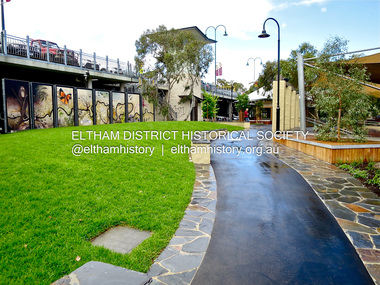
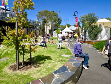
 Eltham District Historical Society Inc
Photograph - Digital Photograph, Jim Connor, Eltham Town Square, Commercial Place, Eltham, 23 June 2016
... running between Arthur Street and Pryor Street. Its origins... running between Arthur Street and Pryor Street. Its origins ...Eltham Town Square is centred along Commercial Place running between Arthur Street and Pryor Street. Its origins stretch back to the first design proposals developed in 1979 by then Shire Planner Rodney Roscholler who later went on to become Eltham Shire Council CEO, and Cr. Robert Allenjim connor collection, commercial place, eltham shopping centre, eltham town square, bakers delight, ferguson plarre bakehouses -
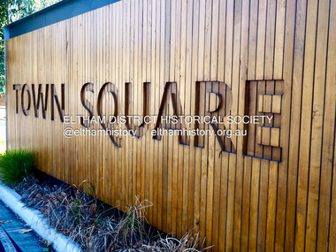
 Eltham District Historical Society Inc
Photograph - Digital Photograph, Jim Connor, Eltham Town Square, Commercial Place, Eltham, 25 February 2017
... running between Arthur Street and Pryor Street. Its origins... running between Arthur Street and Pryor Street. Its origins ...Eltham Town Square is centred along Commercial Place running between Arthur Street and Pryor Street. Its origins stretch back to the first design proposals developed in 1979 by then Shire Planner Rodney Roscholler who later went on to become Eltham Shire Council CEO, and Cr. Robert Allenjim connor collection, commercial place, eltham shopping centre, eltham town square -
 Eltham District Historical Society Inc
Photograph - Digital Photograph, Jim Connor, Eltham Town Square, Commercial Place, Eltham, 18 April 2018
... running between Arthur Street and Pryor Street. Its origins... running between Arthur Street and Pryor Street. Its origins ...Eltham Town Square is centred along Commercial Place running between Arthur Street and Pryor Street. Its origins stretch back to the first design proposals developed in 1979 by then Shire Planner Rodney Roscholler who later went on to become Eltham Shire Council CEO, and Cr. Robert Allenjim connor collection, commercial place, eltham shopping centre, eltham town square, the common, third chapter, jock & eddie, alter it -
 Greensborough Historical Society
Map, Melbourne and Metropolitan Board of Works. Survey Division, MMBW, Yarra 2500 / 11.21. Bundoora, east of Plenty Road, 1979_01
... and Whittlesea 239. Prominent streets include: Grimshaw Street... Valley 257, Preston 225 and Whittlesea 239. Prominent streets ...Melbourne and Metropolitan Board of Works. Yarra 2500 [base map] 11-21. Bundoora, east of Plenty Road. Parish of Keelbundoora 2856, Municipalities of Diamond Valley 257, Preston 225 and Whittlesea 239. Prominent streets include: Grimshaw Street, Settlement Road and Plenty Road. Includes Yulong Park.MMBW Map in 1:2500 [scale] series. Cream parchment with green tape reinforcing on edges and punched holes on left edge.mmbw, melbourne and metropolitan board of works, shire of diamond valley, bundoora - maps -
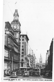 Melbourne Tram Museum
Postcard, Valentine's, "Post Office, Elizabeth Street, Melbourne", late 1930s
... "Post Office, Elizabeth Street, Melbourne"...Valentine's postcard titled "Post Office, Elizabeth Street...Valentine's postcard titled "Post Office, Elizabeth Street ...Valentine's postcard titled "Post Office, Elizabeth Street, Melbourne", Number 2331, looking south from Little Bourke Street towards Flinders Street Railway Station. In the view is W5 class tram 762 (Coburg, Route 20), the Post Office and London Stores are on the left with many cars and pedestrians.Yields information about Elizabeth St, during the late 1930s.Postcard - printed, unused, Valentine Seriestrams, tramways, w5 class, tram 762, route 20, elizabeth st -
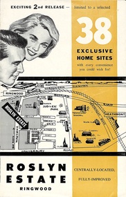 Ringwood and District Historical Society
Flyer, Land Sale Brochure - Roslyn Estate, Ringwood, Vic. - circa 1960s
... Subdivision includes Daisy Street, Vale Street, Joan Court... Road Ringwood North melbourne Subdivision includes Daisy Street ...Land sale advertisement for 2nd release of residential sites with area map, layout of the estate, terms of sale, and summary of local facilities and services.Subdivision includes Daisy Street, Vale Street, Joan Court, Christine Court, and Westmore Drive. (Agent) Heathmont Estate Agency, 103 Canterbury Road, Heathmont. (Phone) WU7808-9. Brochure also includes map with streets marked as "Sold" - Reilly Street, Adrian Court, Daisy Street, Jarma Road, Joel Court, and Ross Court, with comment that "all home sites in the first release have already been sold, and most built on." -
 Warrnambool and District Historical Society Inc.
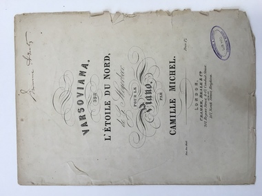
Work on paper - Sheet music, Varsoviana sur L’Etoile Du Nord, 1860s
... Street & 67, Conduit Street and at 167, North Street, Brighton.’ ...201 Regent Street, London, England..., Cramer, Beale & Co., 201,Regent Street & 67, Conduit Street ...This piece of music is the varsoviana dance piece from the Giacomo Meyerbeer opera, ‘L’Etoile Du Nord’ arranged by Camille Michel. The varsoviana was a slow graceful dance originating in Poland in 1850 and appearing in Australia in 1856. ‘L’Etoile Du Nord’ was a comic opera in three acts composed by Giacomo Meyerbeer in 1854. Meyerbeer was the most successful stage composer of the 19th century but his works are rarely performed today. Camille Michel was an editor, composer, author and arranger working from the 1840s to the 1880s. The varsoviana music arrangement probably dates from the late 1850s or 1860s. It is not clear who ‘Minnie Henty’ was but it is most likely that she was Minnie Adair who married George Henty, the son of Stephen and Jane Henty, pioneer settlers in Western VictoriaThis sheet music is most important mainly because of the ‘Minnie Henty’ signature. The Henty family members, founders of the first permanent Victorian settlement at Portland, were influential in the history of the Warrnambool area because of their connections with surrounding properties and with coastal shipping. The music also has social significance as an example of music popular in 19th century drawing rooms.This is a two-page piece of sheet music (cover and two pages of music notation) with the material printed in black on cream paper. The back cover is blank and the front cover has the title and names of the composer and the arranger with ornate scrolls around the printing. The edges and fold of the pages are much tattered and torn in some places. There is also a Warrnambool and District Historical Society stamp on the front cover and the signature of Minnie Henty. Front Cover: ‘Minnie Henty’ ‘Varsoviana sur L’Etoile Du Nord de G. Meyerbeer pour le piano par Camille Michel, Ent.Sta.Hall., Price 1s/-, London, Cramer, Beale & Co., 201,Regent Street & 67, Conduit Street and at 167, North Street, Brighton.’ henty family, giacomo meyerbeer, camille michel -
 Federation University Historical Collection
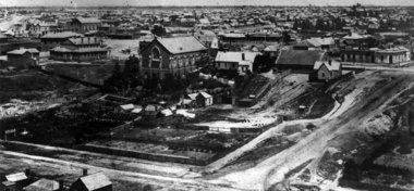
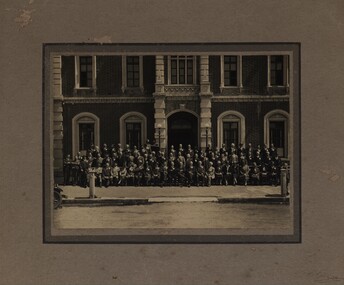
Photograph - Black and White, Gathering outside the Gordon Memorial Technical School, Geelong
... of the building in Fenwick Street near Little Malop Street corner, Geelong... Street near Little Malop Street corner, Geelong. The doorway ...Gordon Institute of TAFE opened in 1887 as the Gordon Memorial Technical School. Photograph shows the area of the building in Fenwick Street near Little Malop Street corner, Geelong. The doorway is the Davidson Restaurant entrance.Large group outside entrance to Gordon Memorial Technical School, Geelong