Showing 23714 items
matching creeks
-
 Bendigo Historical Society Inc.
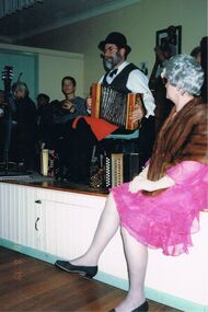
Photograph - PETER ELLIS COLLECTION: PETER ELLIS ON STAGE, 19th June, 1998
Colour photograph. Peter Ellis sitting on stage. Woman in pink dress with fur sitting on edge of stage. Back of photo reads: Emu Creek at Spring Gully Hall. Date stamped '98 6 19.person, individual, peter ellis oam -
 Bendigo Historical Society Inc.
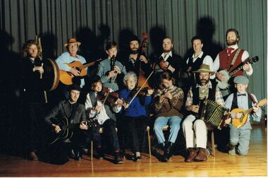
Photograph - PETER ELLIS COLLECTION: BAND
Colour photograph. Band seated for photo. Drum. Guitar. Bass recorder. Concertina. Banjo. Lute. Accordion. Violin. Mrs Corry. Peter Ellis. Back of Photo reads: Emu Creek late 1980's.entertainment, music, bush band -
 Bendigo Historical Society Inc.
Object - EMU CREEK BUSH BAND COLLECTION: HISTORY, 1990s
. Documents and correspondence relating to the establishment of the Emu Creek Bush Band. J. Ottrey, M. Smith, H. Mcqueen, D. Ottery, P. Ellis. Includes notes about the original Bush Dance and Music Club. -
 Bendigo Historical Society Inc.
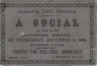
Ephemera - Old Time Dance Guide
BHS CollectionA ticket for a social dance at the Assembly Hall in Hepburn in aid of the Daylesford Hospital on Wednesday November 9, 1898. The ticket is on grey card with black text with a black decorative border. Emu Creek Bush Band Collection.emu creek bush band, australian colonial dance, hepburn, daylesford hospital -
 Tarnagulla History Archive
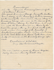
Handwritten statement: District boundaries, Boundaries, unknown
Murray Comrie Collection. A handwritten statement on lined paper relating to boundaries of the Special Licensing District of the Northern Circuit (court). Note on lower section states that the statement 'was pasted on cover of License Register Petty Sessions Sandy Creek 1860'.tarnagulla, court, petty sessions, licensing -
 Eltham District Historical Society Inc
Slide, Construction of Eltham Town Park, 22 Feb 1974
Construction of Eltham Town Park, later renamed Alistair Knox Park. In the foreground is where the Diamond Creek Trail runs along the creek and in the distance is the Bridge Street bridge.35 mm colour positive transparency Mount - Agfacolor Service (Blue)alistair knox park, eltham town park, bridge street bridge -
 Eltham District Historical Society Inc
Slide, Construction of Eltham Town Park, 22 Feb 1974
Construction of Eltham Town Park, later renamed Alistair Knox Park. View looking towards Bridge Street and shows the Diamond Creek and formation of the Diamond Creek Trail.35 mm colour positive transparency Mount - Agfacolor Service (Blue)alistair knox park, eltham town park, bridge street bridge, diamond creek -
 Eltham District Historical Society Inc
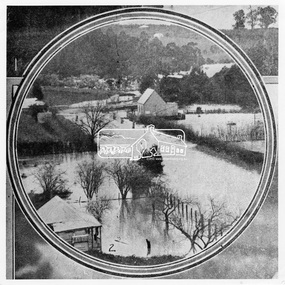
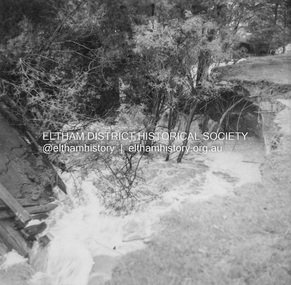
Photograph, Leader Publishing Co, Floods at Diamond Creek, Sep. 1924
The Diamond Creek in flood in Diamond Creek township. View north along Diamond Street. The building in the middle distance is the Methodist Church. From "The Leader", 6 September 1924.This photo forms part of a collection of photographs gathered by the Shire of Eltham for their centenary project book, "Pioneers and Painters: 100 years of the Shire of Eltham" by Alan Marshall (1971). The collection of over 500 images is held in partnership between Eltham District Historical Society and Yarra Plenty Regional Library (Eltham Library) and is now formally known as 'The Shire of Eltham Pioneers Photograph Collection.' It is significant in being the first community sourced collection representing the places and people of the Shire's first one hundred years.Digital imageshire of eltham pioneers photograph collection, diamond creek, floods, methodist church, diamond creek (creek), diamond street, 1924 -
 Falls Creek Historical Society
Booklet - Falls Creek Cross Country Trail Guide 1999
This publication was developed by the Falls Creek Resort Management Committee to promote activities and facilities at Falls Creek for the Winter Season 1999. It was a publication specifically focused on cross country skiers. This item is significant because it illustrates how Falls Creek has been marketed and promoted over time.A coloured fold out trail guide including a map of all trailsfalls creek trails, falls creek marketing, falls creek promotion, cross country skiing -
 Eltham District Historical Society Inc
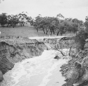
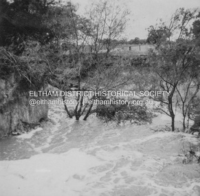
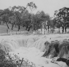
Album - Photograph, J.A. McDonald, Dixons Creek Road, 23 Sep. 1955
Dixons Creek in floodRecord of various Shire of Eltham infrastructure works undertaken during the period of 1952-1962 involving bridge and road reconstruction projects, sometimes with Eltham Shire Council Project Reference numbers quoted. It was during this period that a number of significant improvements were made to roads and new bridges constructed within the shire that remain in place as of present day (2022). In many situations, the photos provide a tangible visible record of infrastructure that existed throughout the early days of the Shire. The album was put together by or under the direction of the Shire Engineer, J.A. McDonald.1955-09-23, bridge construction, dixons creek bridge, dixon's creek road, flood damage, floods, infrastructure, road construction, shire of eltham -
 Eltham District Historical Society Inc
Album - Photograph, J.A. McDonald, Dixons Creek Road, 23 Sep. 1955
Dixons Creek in floodRecord of various Shire of Eltham infrastructure works undertaken during the period of 1952-1962 involving bridge and road reconstruction projects, sometimes with Eltham Shire Council Project Reference numbers quoted. It was during this period that a number of significant improvements were made to roads and new bridges constructed within the shire that remain in place as of present day (2022). In many situations, the photos provide a tangible visible record of infrastructure that existed throughout the early days of the Shire. The album was put together by or under the direction of the Shire Engineer, J.A. McDonald.1955-09-23, bridge construction, dixons creek bridge, dixon's creek road, flood damage, floods, infrastructure, road construction, shire of eltham -
 El Dorado Museum Association Inc.
Photograph (item) - Digital Image
Clear Creek Dammines, mining, tin, tin mining, sluicing, clear creek, el dorado, eldorado -
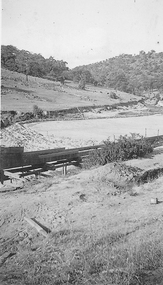
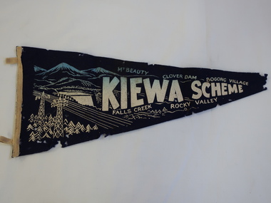 Kiewa Valley Historical Society
Pennant - Kiewa Scheme
Pennants are used to advertise events or places. This pennant includes all the main areas of construction done by the State Electricity Commission of Victoria during their construction of the Kiewa Hydro Electric Scheme. The pennant advertises the highlights in the construction of the Kiewa Hydro Electric Scheme.A small triangular navy blue with gold printing fabric with a strip of woollen bias binding on the left side with a tab at the top and bottom for attaching to a rod to enable the pennant to hang. The background of the printing is of mountains with water flowing out of a dam and in the front on the left power poles and power lines.In gold - large letters"Kiewa Scheme" decreasing in size. On the top also in gold "Mt Beauty" "Clover Dam" and "Bogong Village" and underneath "Falls Creek" Rocky Valley"kiewa scheme, pennant -
 Ringwood and District Historical Society
Photograph, Mullum Mullum Creek- 29-10-89
Black and white photograph"Written on back of photograph" Mullum Mullum Creek From North bank (Munro St side)View generally downstream West of Harrison St Note rubbish and weeds. -
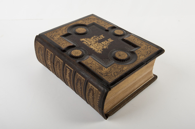 Uniting Church Archives - Synod of Victoria
Bible, Holy Bible
Heavily embossed and patterned in gold leaf bible with black and white plates and illustrations. Dedication page.On spine: "Holy Bible Brown's Notes" Dedication inside front cover: "This Bible was given by Mrs Ferguson to the Strath Creek Church when she left the district in 1901" -
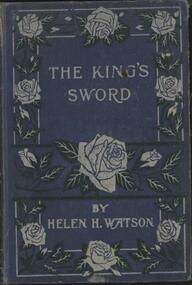 Nillumbik Historical Society Incorporated
Book - Hardcover book, Helen H Watson, The King's Sword
Blue cover with embossed roses in silver on front and blank back, 192 pagesfiction -
 Ballarat RSL Sub-Branch Inc.
Tankard (Sm)
This object relates to SGT Francis John BALMAIN VX133588, 2/1 AUST FORESTRY COYSilver engraved - "HQ R.A.E. 2ND DIV."; Note from Sgt F J Balmain reads "A memento of my 21st Birthday Darwin 24.10.1943 at Coomalie Creek"second world war (ww2), 1939 - 1945, collectables, ballarat rsl, ballarat -
 Queenscliffe Maritime Museum
Photograph - Landed Shark
Shark fishing was important to the Queenscliff Point Lonsdale fishing industry since early 1900s. It is still a popular activity in the area today.Fishing of all kind has been an important industry in the Queenscliff region. Although commercial fishing has greatly diminished, recreational fishing is still an important activity.Laminated photograph of a shark on the crane on Fishermans Pier circa 193820 Beach Street Queenscliffe. Debbie O'Hare? [illegible]. Back of Glenuse Reef in Point Lonsdale. Whole salmon for bait 5am. In creek on crane. 2,100Lbs, 8'6" Girthshark, shark fishing, queenscliff, fishing industry -
![Scene near Bright / [by] Nicholas Caire, circa 1876](/media/collectors/550653872162f11fb04854aa/items/578310d1d0cdd1176c462743/item-media/5783113fd0cdd1176c46de2e/item-fit-380x285.jpg) Kew Historical Society Inc
Kew Historical Society IncPhotograph, Anglo-Australasian Photographic Company, Scene near Bright, c. 1876
Nicholas Caire was born on Guernsey in the Channel Islands in 1837. He arrived in Adelaide with his parents in about 1860. In 1867, following photographic journeys in Gippsland, he opened a studio in Adelaide. From 1870 to 1876 he lived and worked in Talbot in Central Victoria. In 1876 he purchased T. F. Chuck's studios in the Royal Arcade Melbourne. In 1885, following the introduction of dry plate photography, he began a series of landscape series, which were commercially successful. As a photographer, he travelled extensively through Victoria, photographing places few of his contemporaries had previously seen. He died in 1918. Reference: Jack Cato, 'Caire, Nicholas John (1837–1918)', Australian Dictionary of Biography.An original, rare photograph from the series 'Views of Victoria: General Series' by the photographer, Nicholas Caire (1837-1918). The series of 60 photographs that comprise the series was issued c. 1876 and reinforced a neo-Romantic view of the Australian landscape to which a growing nationalist movement would respond. Nicholas Caire was active as a photographer in Australia from 1858 until his death in 1918. His vision of the Australian bush and pioneer life had a counterpart in the works of Henry Lawson and other nationalist poets, authors and painters.‘Scene near Bright’ : Views of Victoria (General Series) No.47 : Albumen silver photograph | Photo on card with Title and Description on reverse | Mounted 24 x 30 cm; Photo 12 x 17 cm.On Reverse: ‘The subject of this illustration is taken on the road to Grouber’s, near the township of Bright, in the Beechworth District. The scenery on the rivers and creeks which surround this township is of a very romantic and picturesque description.’nicholas caire (1837-1918), bright (vic), landscape photography - victoria -
 Greensborough Historical Society
Map, Melbourne and Metropolitan Board of Works. Survey Division, MMBW, Yarra 2500 / 15.24. Diamond Creek, Grassy Flat Road, 1978_02
Melbourne and Metropolitan Board of Works. Yarra 2500 [base map] 15.24. Diamond Creek, Grassy Flat Road. Parish of Nillumbik 3310. Municipality of Diamond Valley 257. Prominent streets include: Everleigh Drive, Broad Gully Road and Clyde Street. Features include the Diamond Creek, Nillumbik Park and Diamond Creek Reservoir.MMBW Map in 1:2500 [scale] series. Cream parchment with green tape reinforcing on edges and punched holes on left edge.mmbw, melbourne and metropolitan board of works, diamond creek - maps, shire of diamond valley -
Canterbury History Group
Book, McWilliam, Gwen, Boroondara Musings
... Creeks ...Book two of a collection of articles by Gwen McWilliam published in the Progress Press from 1990-1993 with many coloured photographs.boroondara, libraries, creeks, richardson> henry handel, mccrae> georgiana, stanley grove, canterbury road, canterbury primary school, railways, schools -
 Bayside Gallery - Bayside City Council Art & Heritage Collection
Flag, Evan Evans, City of Brighton flag
The coat of arms on this flag were granted by the British College of Arms in 1970 and represented Brighton City Council's "growing awareness of the importance of formality and correct symbolism in local government". It replaced the council's crest of a pier and yachting scene and was used as council's seal, emblem on its flag and letterhead. The new Coat of Arms, drawn up by the College of Arms in England, depicts the progression from a seaside gardening community to a modern residential city. The prominent forms are on the shield-like coat of arms include waves and a Lymphad (a ship, symbolic of the sea); a market gardener; an aboriginal man; two horns of plenty with abundant fruit and vegetables (the wealth and plenty) and Elster Creek (now Elster Canal). It is underscored by the motto "By their fruits, ye shall know them". Brighton was first incorporated as a borough on 18 January 1859, it became a town on 18 March 1887 and was proclaimed a city on 12 March 1919.Green flag with circular City of Brighton Coat of Arms in the centre. The central circle is white with a yellow edge, with a polychrome coat of arms featuring: the crest which is two cornucopia with fruits and vegetables, above sits a seagull. The mantle above the helmet is in green and gold. The shield is also green and gold with a lymphad (ship) and blue and white waves. The market gardener, holding a hoe, and Aboriginal figure, bearing a boomerang, support the shield and stand upon the compartment which is soil with a representation of Elster creek. A ribbon below contains the motto in blue 'FRUCTU NOSCITUR'.flag, brighton, city of brighton, coat of arms, college of arms, market gardener, aboriginal, elster creek, lymphad, fructu noscitur, armorial bearings, heraldry, cornucopia, by their fruits ye shall know them, motto -
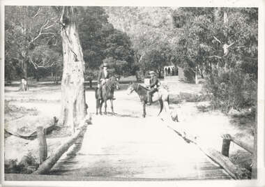 Halls Gap & Grampians Historical Society
Photograph - B/W, C 1920s
The Stoney Creek dray bridge. Stoney Creek has been bridged a number of times on school road since the creek was re-routed in the early 1900s. A dray bridge was built C 1910 by local residents, which stood them in good stead for more than a decade. This bridge was replaced by a higher timber structure. Image two is a story from 1906 relating to Marshall White and his family trying to recross Delley's bridge after finding the Stoney Creek dray bridge washed away.Photo of two men on horseback on a wooden bridge with low log railing. A shelter can be seen in the background and there are thick trees surrounding the road.structures, bridges -
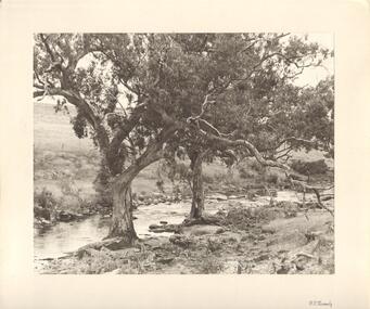 Bendigo Historical Society Inc.
Photograph - TWO LARGE TREES AT EDGE OF CREEK
Black and white photograph. Textured paper of scene on creek, with two attractive trees at water's edge, possibly Bendigo Creek. Sheep in background. Inscriptions: on front - BR corner printed 'FT Kennedy'. On back - hand written in pencil 'Bendigo' rubber stamp 'Frank T Kennedy'. History: James Lerk 22/;6/2001 'Tom Kennedy was a Bendigo man with an interest in photography. With note 'Photographs from Mrs Ella Bourke, 131 Barnard St Bendigo. Ph 438269'. 'Photographs 'Francis (Frank) Thomas Kennedy'.Frank Tom? Kennedyplace, landscape view, see also 2001.153.01, 2001.154.01, 2001.157.01, 2001.158.01, 2001.159.01, 2001.160.01, 2001.161.01, 2001.15.162.01 -
Southern Sherbrooke Historical Society Inc.
Information folder - Cr. Violet Lambert, 1930s & 40s
Folder containing information pertaining to Councillor Violet Lambert. Contents:/letter dated 26th June (2001), Heather Ronald to society, enclosing copies of some of her mother's speeches (listed below)/notes for a speech, "Visit to Menzies Creek to commemorate the centenary of Victoria 1934", delivered at Menzies Creek primary school/notes for a speech delivered to the Church (?) Ladies' Guild, Belgrave South, n.d. but possibly 1940s/notes for a speech, "Opening the St Martin's Annual Fete at South Belgrave", c.1946.st martins anglican church, belgrave south, menzies creek primary school, mrs ramshaw, formerly florence butlin -
 Ballarat Tramway Museum
Photograph - Digital image, Wal Jack, 12/06/1955 12:00:00 AM
Yields information the reconstruction of the Canadian Creek Bridge in 1955.Digital image from the Wal Jack Ballarat Album of No. 32 at Canadian Creek bridge in Barkly St, Mt Pleasant during the reconstruction of the bridge. Photo dated 12-6-55 and shows the reconstruction work in progress. Tram was isolated to enable the service in Barkly St during the reconstruction of the Canadian Creek bridge during June-July 1955, see Reg Item 5155, 5157 as well and 5301, 5302 and 5305. No. 35 was the service car, shows the detour sign as well See image i2 for rear of photograph.On rear in ink "SEC Ballarat No. 32 in Barkly St at Steinfield St Bridge under repairs. 13-6-55." In top right hand corner is Wal Jack stamp with number T178 written in.trams, tramways, mt pleasant, canadian creek, barkly st, tram 32 -
 Kew Historical Society Inc
Map, MMBW, MMBW Plan No.68 Kew, 1900-1910
The Melbourne and Metropolitan Board of Works (MMBW) was established by an act of the Victorian Parliament in 1890 to prepare for and to implement a sewerage and water reticulation system across what was then inner Melbourne, its surrounding and middle distance suburbs, including Kew. The MMBW was disbanded in 1991.The map collection of the Kew Historical Society has at its core the historic maps assembled and originally stored in the City Engineer's Department of the City of Kew. These include maps in a number of scales. The vast majority of maps were produced by the MMBW in the first two decades of the twentieth century, and are solid working maps, backed by linen for durability. These maps are historically significant to Kew, the City of Boroondara and to the history of the development of state utilities in Victoria. A number of the Kew maps have additional details added by former municipal officers, including the levels reached by various floods. As these were working documents, information was added to them long after the period of their initial production and distribution.Early map of part of the Borough of Kew, created in the first decade of the twentieth century, at a scale 160 ft to 1 inch. The map covers what was then the north central part of Kew, bordered in the north by Oak Avenue, in the west by the Yarra River and Connor's Creek, in the south by Beresford and Carnegie Avenues, and in the east by Glass's Creek and Burke Road. The map shows the extent of urban development by that time, prominent institutions and the outlines of built structures in the municipality. Contour lines and the levels of historic floods were added in ink to the map at a later stage.MELBOURNE AND METROPOLITAN BOARD OF WORKS / PLAN NO. 68 / KEW melbourne & metropolitan board of works, mmbw maps, mmbw plans, borough of kew, cartography -
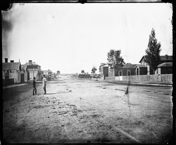 Stawell Historical Society Inc
Photograph, Longfield Street Stawell with buildings on both sides Holtermann Photograph April 1874, by Charles Bayliss of American and Australasian Photograph Co
Part of Holtermann Collection Ref FL1253748.Pleasant Creek Longfield Street Scene looking South. Hotels on left Camp Hotel, Constitution Hotel and Shamrock Hotel on other side of Seaby Street. Pleasant Creek Court House, Shire Hall and Literary Institute on Right. Smith's Store in distance on right, on other side of Seaby Street. One of the two gentlemen talking is Merlin's photographic assistant Charles Bayliss who toured the Victorian Gold towns producing photographs for American Australasian Photographic Company. From State Library NSW records, Holtermann's Collection. stawell, pleasant creek, hotels