Showing 2265 items
matching map collections
-
 Bendigo Historical Society Inc.
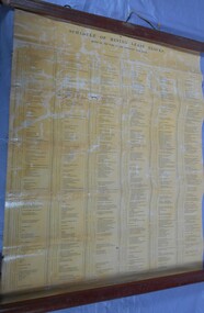
Document - MARKS COLLECTION: MINING LEASE BLOCKS 1873
... to the mine site shown on Sandhurst Gold Field map. Document MARKS ...Plan mining lease blocks 1873, timber hanger on top two brass rings, securing tape, round timber holder on bottom, scroll. On top Schedule of Mining Lease Blocks shown on the plan of the Sandhurst Gold Field, Published May 1873' Names of mining Companies listed with identifying number and area of mine site. E.g. '447 Johnson's Reef Gold Mines 7a, 2r, 8 p (acres, roods, perches). Number linked to the mine site shown on Sandhurst Gold Field map.bendigo, mining, mining lease blocks 1873 -
 Bendigo Historical Society Inc.
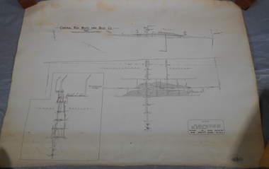
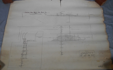
Administrative record - Central Red, White and Blue Mine map
Draftsman's drawing of Central Red, White and Blue Mine Map. Printed by Troedel & Cooper Pty Ltd. Mr. H. Cumby, Surveyor Forms part of the Margaret Roberts Collection of mining records.bendigo, margaret roberts, gold, map, mine, central red white & blue -
 Bendigo Historical Society Inc.
Map - STRUGNALL COLLECTION: BENDIGO GOLD FIELD GEOLOGICAL SURVEY, 1936
... BHS Collection BENDIGO Gold mining geological map Dept ...BHS CollectionBendigo Goldfieds Geological Survey. Prepared in the Bendigo Office Lower Section of original map. Note with map says other items donated - yet to be catalogued. TO BE FOUNDDept of Mines Victoriabendigo, gold mining, geological map -
Bendigo Historical Society Inc.
Map - STRUGNELL COLLECTION: BENDIGO GOLD FIELD GEOLOGICAL SURVEY, 1936
... BHS Collection BENDIGO Gold mining geological map Dept ...BHS CollectionBendigo Goldfieds Geological Survey. Prepared in the Bendigo Office Top Section of original map.Dept of Mines Victoriabendigo, gold mining, geological map -
Bendigo Historical Society Inc.
Map - BENDIGO GOLDFIELD, 1873
BHS CollectionBendigo Goldfieds mining Lease blocks. April 1873 Topographic map. Surveyed and completed by R Brough April 1873Dept of manufacturing and Industry Development.bendigo, gold mining, mining lease blocks -
Bendigo Historical Society Inc.
Map - CAMPBELL COLLECTION: PARISH MAPS
... BHS Collection Nineteen Parish maps of Bendigo area ...BHS CollectionNineteen Parish maps of Bendigo area in a plastic bag. Mostly original maps. Copies or originals of all maps are available to access in the Map Cupboard. Not catalogued separately. Maps come from Don Stewart, 10 Avery's Rd. Eaglehawk. Don now deceased. He worked in a Government job in bendigo. -
 Bendigo Historical Society Inc.
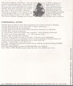
Document - CENTRAL DEBORAH GOLD MINE: COMPLIMENTARY GUIDE TO THE CENTRAL DEBORAH GOLD MINE
BHS CollectionBlack and white bifold document, on front of document 'Complimentary guide to the Central Deborah Gold Mine'. Inside is a map and numbered features of the mine site with interpretive information.bendigo, mining, central deborah gold mine -
 Bendigo Historical Society Inc.
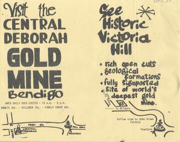
Document - CENTRAL DEBORAH GOLD MINE: ADVERTISING FLYER
BHS CollectionA4 advertising flyer,yellow background, black text. 'Visit the Central Deborah Gold Mine Bendigo' 'See Historic Victoria Hill'. Handrawn mud maps for each site on bottom of page.bendigo, mining, crentral deborah gold mine -
Bendigo Historical Society Inc.
Book - BENDIGO THE GOLDEN AGE RETRACED, 1973
BHS CollectionBendigo The Golden Age Retraced History of Bendigo 64 pages. Black and white illustrationd. Mallaya Publications. Printed by Brown Prior Anderson Melbourne. Mustard coloured soft cover. Illustration of tram and poppet head on the cover. Map od Bendigo printed inside front and back covers.Jan Neil -
 Melbourne Tram Museum
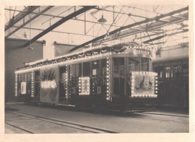
Photograph - Melbourne W1 421 decorated for the visit of the Duke and Duchess of York, Melbourne & Metropolitan Tramways Board (MMTB), 1927
Photograph and associated infomation of Melbourne W1 421decorated as an "illuminated" tramcar for the visit of the Duke and Duchess of York to Victoria April 21 to May 12, 1927 and the opening of Canberra on May 9, 1927, taken at Preston Workshops. Associated Digital images: .2 - extract from the 1926-27 MMTB Annual Report. .3 - image from the David Featherstone collection of the tram being fitted out at Preston Workshops .4 - image of the tram at night, from the Annual Report. Note Tasmania is missing from the map on the side of the tram. Yields information about the decoration of a Melbourne tram for a Royal visit in 1927 Black and White photograph of Melbourne W1 421decorated as an "illuminated" tramcar for the visit of the Duke and Duchess of York 1927illuminated trams, decorated trams, royal visit, duke of york, preston workshops, w1 class, mmtb, tram 421 -
 Bendigo Historical Society Inc.
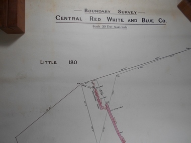
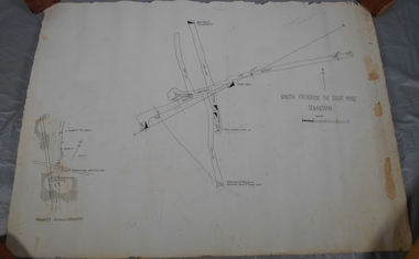
Administrative record - Central Red White and Blue
Draftsman's drawing Boundary Survey Central Red White and Blue Map Forms part of the Margaret Roberts Collection of mining records.bendigo, margaret roberts, gold, map, mine, central red white and blue -
 Bendigo Historical Society Inc.
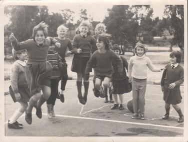
Photograph - Bendigo East State School playground photo c.1970
A black and white photograph of ten girls from Bendigo East State School. c1970. The girls are pictured in the school grounds and some are wearing uniform. Six of the girls are jumping in the air. On the asphalt appears to be a painted outline of a map of Australia. On the back of the photograph is written : Norma Worme. East Bgo School .Kaylene Worme 5th from left. 6th Debbie Luke .Sally Theodore 1st . Benbow 4th. Norma Worme c/o Sheryl Worme.Gemma Starr Collectionbendigo east state school, bendigo schools, worme, gemma starr collection -
 Bendigo Military Museum
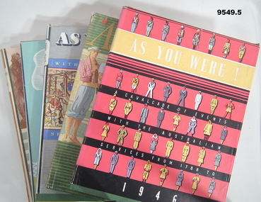
Book - AS YOU WERE SERIES, 1946 -1950, The Australian Military Forces by Australian War Memorial Canberra, A.C.T, "R.A.N., A.M.F. and R.A.A.F.", 1946-1950
For this series - refer to Cat No's, 9546.7, 9547.4, 9548.4, 9549.5. Items in the collection of "William John Sullivan" VX 57829. Refer Cat No. 9523P for his service details.1. - 5. Hard cover book with dust cover. Hardcover - cardboard with green buckram. Dark blue print on front and spine. All pages - cut, plain off white colour paper. Illustrated in black and white, and colour photographs, paintings, maps, sketches and diagrams. 172-202 pages. Dust cover - paper. All end papers illustrated. 1. "AS YOU WERE!/ A CAVALCADE OF EVENTS/ WITH THE AUSTRALIAN/ SERVICES FROM 1788/ TO 1946" 1946 Hard cover illustration - silhouette of three servicemen. Dust cover - white colour print front and spine. Illustrated - five rows of service personnel in various uniforms. 2. "AS YOU WERE/ with the / AUSTRALIAN SERVICES/ FROM 1788 TO/ 1947", 1947. Hardcove4r illustration - silhouette portrait of three servicemen. Dust cover - front gold colour print on front, beige colour print on spine. Illustrated - six service personnel in various uniforms in colour. Back - painting and information "AUSTRALIAN WAR MEMORIAL, ANZAC DAY 1947". 3. "AS YOU WERE/ WITH THE AUSTRALIAN/ SERVICES FROM 1788 TO/ 1948", 1948. Dust cover, white, black and yellow print on front and spine. Illustrated - colour - various service personnel in montage collection. 4. "AS YOU WERE/ 1949", 1949. Hardcover - print on spine only. Dust cover - yellow and blue print on front and spine. Illustrated - stylised colour sketch of three service personnel. 5. "AS YOU WERE/ 1950", 1950. Hardcover - small silhouette illustration of two servicemen, Navy and Army with two aircraft above. Dust cover - black and green print on front and spine. Background horizontal lines, green, white and brown. Illustrated - sepia tones drawing of a group of service personnel. book series, as you were, military history, biographies, william john sullivan -
 Bendigo Historical Society Inc.
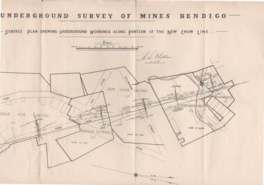
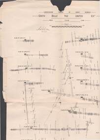
Map - STRUGNELL COLLECTION: NEW CHUM LINE, 25/5/01
... , Shenandoah Co. Shamrock Co.. Map STRUGNELL COLLECTION: NEW CHUM LINE ...Map, Surface Plan Showing underground workings along portion of the New Chum Line.South Belle Vue United, Eureka Extended, New Chum Railway, Shenandoah Co. Shamrock Co..A.S.Whitelawmap, bendigo, new chum line -
 Bendigo Historical Society Inc.
Map - STRUGNELL COLLECTION: UNDERGROUND SURVEY OF MINES BENDIGO, 25/05/01
... .,F.G.S.,Acting Government Geologist. Map STRUGNELL COLLECTION ...Map, Underground Survey of Mines, Bendigo, South Belle Vue United Coy, New Chum Line, Surveyed under the Supervision of H.Herman,B.C.E.,F.G.S.,Acting Government Geologist.A.S.Whitelawmap, bendigo, belle vue united coy -
 Bendigo Historical Society Inc.
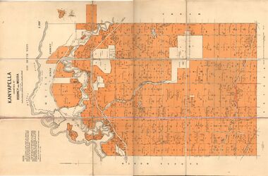
Map - JACK FLYNN COLLECTION: KANYAPELLA, 22/05/1939
... . Parish plan. Map JACK FLYNN COLLECTION: KANYAPELLA ...Map: Parish of Kanyapella, Counties of Rodney and Moira. Parish plan.By Authority, T. Rider Acting Govt, Printer Melbourne. Drawn and Reproduced at the Dept. of Lands and Survey, Melbourne, Victoria.map, moira, parish plan, kanyapella, counties of rodney and moira -
 Bendigo Historical Society Inc.
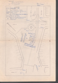
Document - BASIL MILLER COLLECTION: MAP - CHARING CROSS
... BASIL MILLER COLLECTION: MAP - CHARING CROSS.... Tramways' on reverse. Document BASIL MILLER COLLECTION: MAP ...Map showing Charing Cross, Bendigo area. Details written suggest plans for an ANZAC Day Service. Cream coloured paper and black print with additions written by hand in blue ink. Numerous markings in blue ink on front. 'the Manager, SEC, Hargreaves Street Bendigo, ref. Tramways' on reverse.basil miller, bendigo trams, state electricity -
 Bendigo Historical Society Inc.
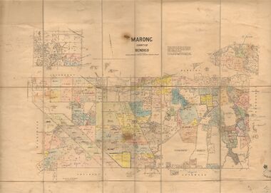
Map - JACK FLYNN COLLECTION: MARONG, June 1933
... of Bendigo. Parish plan. Map JACK FLYNN COLLECTION: MARONG ...Map: Parish of Marong, County of Bendigo. Parish plan.By Authority W.M. Houston, Government Printer. Drawn and reporduced at the Dept., of Lands and Survey, Melbourne, Victoria.map, bendigo, parish plan, marong -
 National Vietnam Veterans Museum (NVVM)
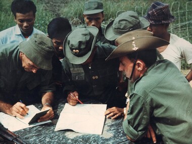
Photograph, Gibbons, Denis, Mekong Delta Operations
Denis Gibbons (1937 – 2011) Trained with the Australian Army, before travelling to Vietnam in January 1966, Denis stayed with the 1st Australian Task Force in Nui Dat working as a photographer. For almost five years Gibbons toured with nine Australian infantry battalions, posting compelling war images from within many combat zones before being flown out in late November 1970 after sustaining injuries. The images held within the National Vietnam Veterans Museum make up the Gibbons Collection. A colour photograph of two members of the Australian Army Training Team Vietnam (AATTV) operating with the Army Of The Republic Of Vietnam (ARVN), as they check map references and other intelligence information with an ARVN Officer prior to commencing operations in the Mekong Delta of IV Corps.photograph, aattv, mekong delta, army of the republic of north vietnam (arvn), iv corps, gibbons collection catalogue, denis gibbons, photographer, vietnam war, australian army training team vietnam (aattv), intelligence information -
 Bendigo Historical Society Inc.
Document - RALH BIRRELL COLLECTION: OLD MINING SITES WHITE HILLS, Dr. Ralph Birrell (now deceased)
4-page typed document, prepared by Dr. Ralph Birrell, on the significance of the former mining sites on the White Hills. Document describes the 'area adjacent to the old Railway Workshops as shown on attached map'. A further addition (slip of paper, typed) to the paper describes the location of the Whiter Hills of White Hills: 1st White Hill is east of Lake Weeroona The 2nd and 3rd White Hills are around Strickland Road, former East Bendigo Primary School, Baden/Powell Streets The 4th and 5th White Hills are east of Napier and Grace Street The 6th White Hill is east of Plumridge Street The 7th White Hill is east of Bosquet Street. -
Bendigo Historical Society Inc.
Booklet - Victoria Hill - A historical Background
BHS CollectionsSpiral bound booklet (24 pages) entitled 'Victoria Hill' a historical background of Victoria Hill and the surrounding area. Colour image of a poppet head on front cover. Illustrated with B&W and colour photos and a map. Revised and edited in 2012 by Philip Wilkin from an original article by Mr. Albert Richardson 'The Rich Victoria Hill and its historical associations.'Signed in ink 'Philip Wilkin 3rd May 2012' on page 3victoria hill, gold mines -
Bendigo Historical Society Inc.
Document - MARKS COLLECTION: PARISH PLAN OF WHITE HILLS
Sepia coloured map showing allotments in Parish of Sandhurst (White Hills) Written on LH side of map town and Suburban Lots White Hills Parish of Sandhurst. Scale is shown in chains. Surveyed by Horage Walker. Photo lithographed at the Department of Lands & Survey, Melbourne by J.Noone, Price 1/-. 6th. January 1865. Map shows Race Course Reserve at top of sheet, Municipal boundary is marked on LH side. Comments re vegetation throughout map. For example, poor soil timbered with Box scrub.bendigo, planning, white hills parish map -
 Bendigo Historical Society Inc.
Administrative record - Central Red White and Blue Company Mine map
Draftsman's drawing of Central Red, White and Blue Mine. Printed by Troedel & Cooper Pty Ltd, Surveyor Mr. H. Cumby, Bendigo April 1913 Forms part of the Margaret Roberts Collection of mining records.bendigo, margaret roberts, gold, central red white and blue gold mine, map -
 Bendigo Historical Society Inc.
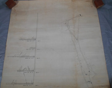
Administrative record - South Frederick The Great Mine, Sebastian, Mine map
Draftsman's drawing of South Frederick The Great Mine, Sebastian. Forms part of the Margaret Roberts Collection of mining records.Pencil markings additions to mapbendigo, margaret roberts, gold, map, south frederick the great mine -
 Bendigo Historical Society Inc.
Administrative record - South Frederick The Great Mine, Sebastian, Mine map
Draftsman's drawing of South Frederick The Great Mine, Sebastian. Transverse and longitudinal Plan Forms part of the Margaret Roberts Collection of mining records.bendigo, margaret roberts, gold, map, south frederick the great mine -
 Bendigo Historical Society Inc.
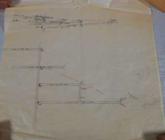
Administrative record - Mine Map
Draftsman's drawing Mine Map. Additional pencil markings. Forms part of the Margaret Roberts Collection of mining records.bendigo, margaret roberts, gold, map, mine -
 Bendigo Historical Society Inc.
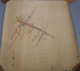
Administrative record - Lansell's Concord Mine Map
Draftsman's drawing Lansells Concord Mine Map. Additional pencil markings for legend Forms part of the Margaret Roberts Collection of mining records.bendigo, margaret roberts, gold, map, mine, lansell's concord -
 Bendigo Historical Society Inc.
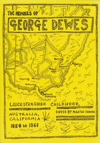
Book - THE MEMOIRS OF GEORGE DEWES, 2005
BHS CollectionThe Memoirs of George Dewes, Leicestershire Childhood, Australia, California 1826 - 1861. 231 pages with pages 132 to 138 relating to Bendigo, photographs and maps.Martin Coombsbook, life on goldfields, gold rush, life on gold fields, bendigo gold fields. -
Glenelg Shire Council Cultural Collection
Map, Railway Map of Victoria, n.d
Port of Portland CollectionFront: verso - 'Way and Works branch railway Department Melbourne Dec 1954.'port of portland archives, railway, map, 1954, 1950s -
 Greensborough Historical Society
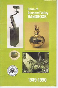
Booklet, Shire of Diamond Valley Handbook 1989-1990, 1989_
Guide to services provided by Shire of Diamond Valley. The Shire of Diamond Valley was a Local Government Area located about 20 kilometres northeast of Melbourne. The shire covered an area of 74.38 square kilometres and existed from 1964 until 1994.Annual guide to services in Shire of Diamond Valley32 pages, col illus., maps. Cover illustration of items from the Diamond Valley Shire Art Collection. 2 copiesshire of diamond valley, greensborough, handbooks