Showing 3012 items
matching metropolitan
-
 Port Melbourne Historical & Preservation Society
Map - Albert Park, South Melbourne and part of Port Melbourne, MMBW
Melbourne and Metropolitan Board of Works Plan 9E-NE depicting Albert Park, S. Melbourne and (part of) Port Melbourne.mmbw, melbourne and metropolitan board of works -
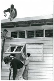 NMIT (Northern Melbourne Institute of TAFE)
Photographs: NMCOT 1980s Building Trades students, Photographs: NMCOT1980s Building Trades students
Black and white photographs of Northern Metropolitan College of TAFE Building trades students. Undated but estimated to be 1980s. Various sizespreston college of tafe, northern metropolitan college of tafe, students, building trades students, nmit -
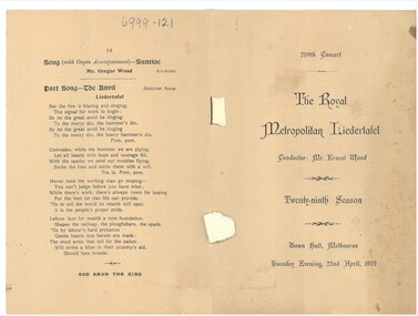 Bendigo Historical Society Inc.
Document - HAMILTON COLLECTION: CONCERT PROGRAM, 1902
Document. Concert program for the Royal Metropolitan Liedertafel, Town Hall, Melbourne.1902. Six page program includes lyrics.performing arts, elocution, concert program -
Whitehorse Historical Society Inc.
Map, Legislative Assembly, 1984
State of Victoria Legislative Assembly electoral districts 1983 - 1984 redivision (Melbourne Metropolitan area) Scale 1:50,000State of Victoria Legislative Assembly electoral districts 1983 - 1984 redivision (Melbourne Metropolitan area) Scale 1:50,000State of Victoria Legislative Assembly electoral districts 1983 - 1984 redivision (Melbourne Metropolitan area) Scale 1:50,000victoria. parliament. legislative assembly, electoral boundaries -
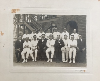 Kew Historical Society Inc
Photograph - M&MTB Cricket Team, c.1926-9
Arthur Henry Miers, pictured in the photograph played for cricket, football and baseball teams in Kew for a number of decades in the first half of the twentieth century. He was born on 22 November 1901, the son of Rodolph Theophilus Miers (1874-1951) and Margaret Frances (Margaretta) Fry (1875-1958). He had two brothers, Rodolph Cecil Miers (1904-80) and Charles Wilfred Miers (1906-88), and a sister Marjorie Elizabeth Miers (1911-84). Arthur Miers died in Kew on 25 January 1966, and after his body was cremated, his body was interred in the Mausoleum of Boroondara General (Kew) Cemetery.Rare early photograph of a Melbourne & Metropolitan Tramways Board cricket team from 1926-9A Melbourne & Metropolitan Tramways Board (MMMTB) cricket team and officials posed in front of a red brick grandstand, mounted on cardDonor note: CRICKET - PHOTO 8" X 6" / ARTHUR MIERS 2ND FROM RIGHT - BACK ROW / VINCENT KELLY - BENDIGOcricket teams, arthur miers, m&mtb -
NMIT (Northern Melbourne Institute of TAFE)
Folder: of documents used for researching the history of NMIT for the 2012 centenary
Manila folders of documents, some photocopies, some original used when researching the history of NMIT for the 2012 centenary. Headings of folders include: Northern Metropolitan College of TAFE Interim & Proposed permanent structure 1980s X 2 Organisational charts Preston College of TAFE – Northern Metropolitan College of TAFE . Amalgamation process Preston College of TAFE and Collingwood College of TAFE. Northern Metropolitan College of TAFE Constitution (includes Model constitution for TAFE College Councils and Consultation paper issued August 1991 by State Training Board. Preston Technical College, Preston Institute of Technology to 1990; Heidelberg Campus of Northern Metropolitan College of TAFE. All folders housed in a box preston college of tafe, preston institute of technology, northern metropolitan college of tafe, history, nmit -
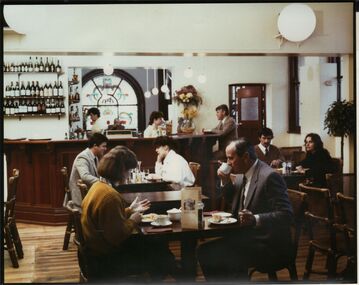 Bendigo Historical Society Inc.
Photograph - AULSEBROOK AND MARTIN COLLECTION: METROPOLITAN HOTEL, HARGREAVES AND BULL STREETS, INTERIOR
Colour photo: Metropolitan Hotel interior. Image shows people sitting at tables in the lounge of the Metropolitan hotel. Wooden bar, timber floor. Arched window in background of photo. On rear of photo: 'Aulsebrook & Martin Pty Ltd., Photographers, 6 Ruth St., Golden Square 3555 Phone 054 437565bendigo, buildings, metropolitan hotel, hargreaves street -
 St Kilda Historical Society
Photograph - Photo map, 17/01/1951
One of a series of photo-maps produced for the Department of Crown Lands and Survey (1857-1983). For correlation with a current map, and access to other historical photo maps of Victoria, see the Historic Photo-Maps Index published by the Department of Environment, Land, Water and Planning at https://services.land.vic.gov.au/DELWPmaps/historical-photomaps/Black and white aerial photograph1414-21 538 Run 19 Lens 12" Melbourne Metropolitan 12150 17.1.51 M586st kilda, st kilda botanical gardens, peanut farm, elwood, 1951, point ormond, elwood canal, st kilda beach -
 St Kilda Historical Society
Photograph - Photo map, 17/01/1951
One of a series of photo-maps produced for the Department of Crown Lands and Survey (1857-1983). For correlation with a current map, and access to other historical photo maps of Victoria, see the Historic Photo-Maps Index published by the Department of Environment, Land, Water and Planning at https://services.land.vic.gov.au/DELWPmaps/historical-photomaps/Black and white aerial photograph1414-20 538 Run 19 Lens 12" Melbourne Metropolitan 12150 17.1.51 M586elwood, elsternwick, st kilda east, balaclava, ripponlea, 1951 -
 St Kilda Historical Society
Photograph - Photo map, 28/01/1951
One of a series of photo-maps produced for the Department of Crown Lands and Survey (1857-1983). For correlation with a current map, and access to other historical photo maps of Victoria, see the Historic Photo-Maps Index published by the Department of Environment, Land, Water and Planning at https://services.land.vic.gov.au/DELWPmaps/historical-photomaps/Black and white aerial photograph1424-44 534 Run 18 Lens 12" Melbourne Metropolitan 12150 28.1.51 M639 -
 St Kilda Historical Society
Photograph - Photo map, 28/01/1951
One of a series of photo-maps produced for the Department of Crown Lands and Survey (1857-1983). For correlation with a current map, and access to other historical photo maps of Victoria, see the Historic Photo-Maps Index published by the Department of Environment, Land, Water and Planning at https://services.land.vic.gov.au/DELWPmaps/historical-photomaps/Black and white aerial photograph1424-43 534 Run 18 Lens 12" Melbourne Metropolitan 12150 28.1.51 M639armadale, malvern, st kilda cemetery, caulfield north, st kilda east, 1951 -
 St Kilda Historical Society
Photograph - Photo map, 30/01/1960
One of a series of photo-maps produced for the Department of Crown Lands and Survey (1857-1983). For correlation with a current map, and access to other historical photo maps of Victoria, see the Historic Photo-Maps Index published by the Department of Environment, Land, Water and Planning at https://services.land.vic.gov.au/DELWPmaps/historical-photomaps/Black and white aerial photographVic 1093-62 Melbourne & Metropolitan Project Run 21 30.1.60 Lens 10" 8.200middle park, albert park, catani gardens, st kilda west, 1960 -
 St Kilda Historical Society
Photograph - Photo map, 30/01/1960
One of a series of photo-maps produced for the Department of Crown Lands and Survey (1857-1983). For correlation with a current map, and access to other historical photo maps of Victoria, see the Historic Photo-Maps Index published by the Department of Environment, Land, Water and Planning at https://services.land.vic.gov.au/DELWPmaps/historical-photomaps/Black and white aerial photographVic 1093-60 Melbourne & Metropolitan Project Run 21 30.1.60 Lens 10" 8.200st kilda, albert park, prahran, windsor, south yarra, 1960 -
 St Kilda Historical Society
Photograph - Photo map, 30/01/1960
One of a series of photo-maps produced for the Department of Crown Lands and Survey (1857-1983). For correlation with a current map, and access to other historical photo maps of Victoria, see the Historic Photo-Maps Index published by the Department of Environment, Land, Water and Planning at https://services.land.vic.gov.au/DELWPmaps/historical-photomaps/Black and white aerial photographVic 1092-36 Melbourne & Metropolitan Project Run 22 30.1.60 Lens 10" 8.200st kilda, st kilda pier, st kilda beach, catani gardens, 1960 -
 St Kilda Historical Society
Photograph - Photo map, 30/01/1960
One of a series of photo-maps produced for the Department of Crown Lands and Survey (1857-1983). For correlation with a current map, and access to other historical photo maps of Victoria, see the Historic Photo-Maps Index published by the Department of Environment, Land, Water and Planning at https://services.land.vic.gov.au/DELWPmaps/historical-photomaps/Black and white aerial photographVic 1092-38 Melbourne & Metropolitan Project Run 22 30.1.60 Lens 10" 8.200st kilda, st kilda beach, st kilda pier, catani gardens, 1960, st kilda botanical gardens, peanut farm -
 St Kilda Historical Society
Photograph - Photo map, 30/01/1960
One of a series of photo-maps produced for the Department of Crown Lands and Survey (1857-1983). For correlation with a current map, and access to other historical photo maps of Victoria, see the Historic Photo-Maps Index published by the Department of Environment, Land, Water and Planning at https://services.land.vic.gov.au/DELWPmaps/historical-photomaps/Black and white aerial photographVic 1092-40 Melbourne & Metropolitan Project Run 22 30.1.60 Lens 10" 8.200st kilda east, balaclava, ripponlea, st kilda cemetery, 1960 -
 St Kilda Historical Society
Photograph - Photo map, 30/01/1960
One of a series of photo-maps produced for the Department of Crown Lands and Survey (1857-1983). For correlation with a current map, and access to other historical photo maps of Victoria, see the Historic Photo-Maps Index published by the Department of Environment, Land, Water and Planning at https://services.land.vic.gov.au/DELWPmaps/historical-photomaps/Black and white aerial photographVic 1092-42 Melbourne & Metropolitan Project Run 22 30.1.60 Lens 10" 8.200malvern, caulfield, caulfield park, 1960 -
 St Kilda Historical Society
Photograph - Photo map, 30/01/1960
One of a series of photo-maps produced for the Department of Crown Lands and Survey (1857-1983). For correlation with a current map, and access to other historical photo maps of Victoria, see the Historic Photo-Maps Index published by the Department of Environment, Land, Water and Planning at https://services.land.vic.gov.au/DELWPmaps/historical-photomaps/Black and white aerial photographVic 1091-112 Melbourne & Metropolitan Project Run 23East 30.1.1960 Lens 10" 8.200elwood, point ormond, elwood park, elwood canal, 1960 -
 St Kilda Historical Society
Photograph - Photo map, 30/01/1960
One of a series of photo-maps produced for the Department of Crown Lands and Survey (1857-1983). For correlation with a current map, and access to other historical photo maps of Victoria, see the Historic Photo-Maps Index published by the Department of Environment, Land, Water and Planning at https://services.land.vic.gov.au/DELWPmaps/historical-photomaps/Black and white aerial photographVic 1091-110 Melbourne & Metropolitan Project Run 23East 30.1.60 Lens 10" 8.200elwood, elsternwick, elsternwick park, ripponlea, st kilda east, caulfield, balaclava, 1960 -
 St Kilda Historical Society
Photograph - Photo map, 30/01/1960
One of a series of photo-maps produced for the Department of Crown Lands and Survey (1857-1983). For correlation with a current map, and access to other historical photo maps of Victoria, see the Historic Photo-Maps Index published by the Department of Environment, Land, Water and Planning at https://services.land.vic.gov.au/DELWPmaps/historical-photomaps/Black and white aerial photographVic 1091-1 Melbourne & Metropolitan Project Run 24East 30.1.60 Lens 10" 8.200elwood, elwood beach, elwood park, 1960 -
 St Kilda Historical Society
Photograph - Photo map, 30/01/1960
One of a series of photo-maps produced for the Department of Crown Lands and Survey (1857-1983). For correlation with a current map, and access to other historical photo maps of Victoria, see the Historic Photo-Maps Index published by the Department of Environment, Land, Water and Planning at https://services.land.vic.gov.au/DELWPmaps/historical-photomaps/Black and white aerial photographVic 1091-2 Melbourne & Metropolitan Project Run 24East 30.1.60 Lens 10" 8.200elwood, elwood park, elwood beach, elsternwick park, 1960 -
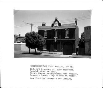 Port Melbourne Historical & Preservation Society
Photograph - Metropolitan Fire Brigade, Liardet Street, Port Melbourne, Arthur Rowan, 1986
As a member of the Port Melbourne Historical and Preservation Society, donor Arthur ROWAN photographed a series of significant buildings in the Port and South Melbourne area over several years. A selection of nineteen of these was presented to the Port Melbourne Society in 1993.Small print mounted on white card, with mounted, typed caption: "Metropolitan Fire Brigade 143-45 [sic] Liardet St Established 1893, First owner Metropolitan Fire Brigade, present owner City of Port Melbourne. Now new Library" [Now 147 Liardet, corner City of Port Phillip]built environment - civic, fire and fire services, arthur rowan -
 Orbost & District Historical Society
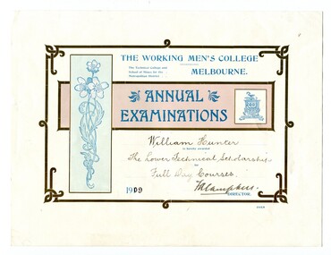
certificates, 1909, 1911, 1912
These four certificates belonged to William Hunter. William Hunter (1893-1971) was a resident of Tatura and Mallacoota. He was a soldier, surveyor and amateur naturalist. The certificates include two first prizes for surveying, a technical scholarship for full day courses and a certificate for Applied Mechanics. William received his Surveying Certificate in April 1916. In June 1887, the Working Men's College opened after Francis Ormond, a noted Victorian philanthropist and member of parliament, suggested that a technical institute be built in Melbourne, offering further education for working men and women. He had offered to match the sum raised through public subscription if the government could provide a site for the College. William Hunter made valuable contributions to our knowledge of far East Gippsland plants. His records were meticulous. These certificates are part of his history.Four card certificates of merit for "Annual Examinations" from the Working Men's College, The Technical College and School of Mines for the Metropolitan District.All four certificates awarded to "William Hunter" and signed by Mordaunt Arundel Hall (accountant & chief clerk WMC) as the Acting Director.hunter-william-surveyor -
Port Melbourne Historical & Preservation Society
Document, Articles of Agreement, 1879
Agreement of conditions relating to the supplying of gas, maintenance of supply , quality of gas and the times that the street lamps were to operate.Handwritten on pale grey paper, the 1879 four page unsigned 'Articles of Agreement' are between the Borough of Sandridge and the Metropolitan Gas Company.built environment - civic, built environment - commercial, borough of sandridge - engineering department, utilities - gas -
NMIT (Northern Melbourne Institute of TAFE)
Report: Skills audits: a practical guide, Alan Baker, 1993, Report: Skills audits: a practical guide, Alan Baker 1993
40 page spiral bound report published in April 1993 by Northern Metropolitan College of TAFE & Northern Industry Education & Training.nietl, northern metropolitan college of tafe, nmit -
 Whitehorse Historical Society Inc.
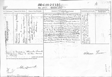
Legal record - Land Title, Land Memorial, 1860
Land Memorial No 963, Book 377, relating to transfer of land in Metropolitan Avenue, Nunawading from William Horan to William Loganhoran, william, logan, metropolitan avenue, nunawading, land sales -
 Melbourne Tram Museum
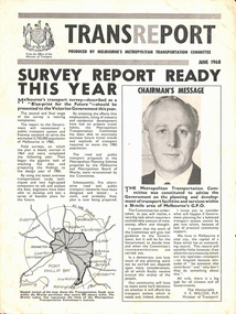
Pamphlet, Minister of Transport, Transport, Jun. 1968
Transport - produced by Melbourne's Metropolitan Transportation Committee. 4 page brochure describing Melbourne's transport survey - "Blue-print for the Future".trams, tramways, reports, planning -
University of Melbourne, Burnley Campus Archives
Plan, Aberfeldie, Trawalla, 1905
Photocopies of Melbourne Metropolitan Board of Works plan showing 2 adjoining house and garden sites in Toorak, Victoria, 'Aberfeldie' and 'Trawalla'. Handwritten, "Map 937a, Map 937b 'Trawalla', Map 937c, Map 937d."toorak, houses, melbourne metropolitan board of works, "aberfeldie", "trawalla" -
 St Kilda Historical Society
Photograph - Photo map, 28/01/1951
One of a series of photo-maps produced for the Department of Crown Lands and Survey (1857-1983). For correlation with a current map, and access to other historical photo maps of Victoria, see the Historic Photo-Maps Index published by the Department of Environment, Land, Water and Planning at https://services.land.vic.gov.au/DELWPmaps/historical-photomaps/Black and white aerial photograph1424-45 SECRET 534 Run 18 Lens 12" Melbourne Metropolitan 12150 28.1.51 M639albert park, st kilda junction, st kilda pier, catani gardens, st kilda, prahran, albert park lake, 1951, middle park, st kilda beach, windsor -
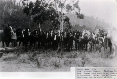 Whitehorse Historical Society Inc.
Photograph, Mitcham Reservoir
Photo of Teams of Horses used for clearing land for the Melbourne and Metropolitan Board of Works reservoir at Mitcham. (Copy of framed Photo see NP842).melbourne and metropolitan board of works, mitcham reservoir