Showing 11166 items matching "planning "
-
 University of Melbourne, Burnley Campus Archives
Work on paper (item) - Student Work, Anton Bialylew, Kneebone Project Landscape Design, Uncertain, probably 2017-2018
Made as an assignment for HORT90035, a subject at Burnley Horticultural College coordinated by Andrew Laidlaw. -
Port Melbourne Historical & Preservation Society
Document - Station Pier Port Melbourne Conservation Plan 1995, Jennifer LEE Heritage Victoria, 1995
Spiral bound photocopy of the Station Pier Conservation Plan prepared by Heritage Victoria foe the Victorian Government Office of Major Projects in October 1995. As well as a Statement of Significance the document contains extensive plans of the Pier.piers and wharves - station pier, heritage victoria -
Canterbury History Group
Ephemera - Shrublands, 16 Balwyn Road Canterbury, 1/10/2004 12:00:00 AM
Real estate advertisement for the sale by auction of the historic mansion "Shrublands" 16 Balwyn Road Canterbury on 5 October 2002. Includes coloured photographs of the exterior of the house and floor plans for both floors and site plans.canterbury, balwyn road, shrublands, victorian italianate style, verandahs -
 Bendigo Historical Society Inc.
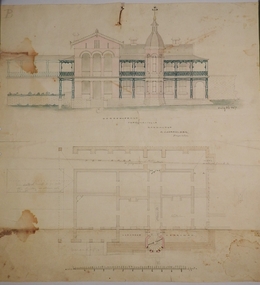
Plan - MARKS COLLECTION: PLAN GARDEN FRONT FORTUNA VILLA SANDHURST - G. LANSELL ESQ., JULY 3RD 1871
Fortuna Villa was owned from 1855 to 1871 by Christopher and Theodore Ballerstedt, Australia’s first mining magnates. In 1871 it was purchased by George Lansell (The Quartz King) being one of Australia’s most successful and adventurous nineteenth century gold mine owners and speculators. Lansell made numerous alterations and extensions to the building and it remained in the Lansell family until 1935. Plan for construction of Fortuna Villa, Sandhurst Title: Garden Front, Fortuna Villa, Sandhurst for G. Lansell Esq. Dated: 3rd July 1871 Coloured plan and elevation Condition: water damage and paper tearsfortuna villa, george lansell, c & t ballerstedt, building plans -
Bendigo Historical Society Inc.
Book - IAN DYETT COLLECTION: FIRE WARDEN'S RECORD BOOK, 1928
Fire Warden's Record Book. Contains detailed drawings and plans for fire services for buildings in Bendigo CBD. Rescued from the Killian's Walk fire by the Donor. Cardboard covers with plans inside. Very poor condition.bendigo, fire brigade, fire warden's books -
 University of Melbourne, Burnley Campus Archives
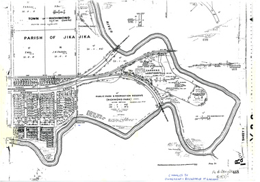
Plan, Allan & Tuxen et al, Public Park & Recreation Reserve (Richmond Park), 1886-1996
Shows changes in ownership of various parts of Richmond Park and Burnley Gardens including University of Melbourne, Amrad, Melbourne City Link, etc. from gazettal in 1873 to 1996Photocopy of plan of Richmond Park and Burnley Gardens with University of Melbourne land acquisition 13.10.1994 hand drawn on it, dates Act revoked and Gazette numbers. Based on plan of Parish of Jika Jika R 19 (3)"Changes to ownership & boundaries of Gardens" in inkpublic parks, recreation reserve, richmond, parish if jika jika, burnley gardens, horticultural society of victoria -
 Kew Historical Society Inc
Plan - Subdivision Plan, Plan of Subdivision of Crown Portion 71, Parish of Boroondara LP12509, Vol.1678, Fol.335526, Before 1930
Prue Sanderson, in her groundbreaking ‘City of Kew Urban Conservation Study : Volume 2 - Development History’ (1988), summarised the periods of urban development and subdivisions of land in Kew. The periods that she identified included 1845-1880, 1880-1893, 1893-1921, 1921-1933, 1933-1943, and Post-War Development. These periods were selected as they represented periods of rapid growth or decline in urban development. An obvious starting point for Sanderson’s groupings involved population growth and the associated economic cycles. These cycles also highlighted urban expansion onto land that was predominantly rural, although in other cases it represented the decline and breakup of large estates. A number of the plans in the Kew Historical Society’s collection can also be found in other collections, such as those of the State Library of Victoria and the Boroondara Library Service. A number are however unique to the collection.Subdivision plans are historically important documents used as evidence of the growth of suburbs in Australia. They frequently provide information about when the land was sold on which a built structure was subsequently constructed as well as evidence relating to surveyors and real estate and financial agents. The numerous subdivision plans in the Kew Historical Society's collection represent working documents, ranging from the initial sketches made in planning a subdivision to printed plans on which auctioneers or agents listed the prices for which individual lots were sold. In a number of cases, the reverse of a subdivision plan in the collection includes a photograph of a house that was also for sale by the agent. These photographs provide significant heritage information relating house design and decoration, fencing and household gardens.The six lots on the south side of Macartney Avenue, between Macartney Avenue and Daniell Place were part of a subdivision that occurred before 1930. The subdivision plan is of interest in that the original name of Daniell Place was Brougham Place. On the Plan, it is noted that lots 5 and 6 (currently 10 and 12 Macartney Avenue) had been sold for £13 each. By November 1930, the new six-roomed villa built on 12 Macartney Avenue was offered for immediate sale at a ‘sacrifice price’. Any offer in reason would be considered, although a £350 deposit was required.subdivision plans - kew, mount street - kew, brougham street - kew , macartney avenue - kew -
 Kew Historical Society Inc
Plan - Subdivision Plan, J R Mathers & McMillan, Glenferrie Road, Cotham Road, Belmont Avenue, Stirling Street, 1910-1930
Pru Sanderson, in her groundbreaking ‘City of Kew Urban Conservation Study : Volume 2 - Development History’ (1988), summarised the periods of urban development and subdivisions of land in Kew. The periods that she identified included 1845-1880, 1880-1893, 1893-1921, 1921-1933, 1933-1943, and Post-War Development. These periods were selected as they represented periods of rapid growth or decline in urban development. An obvious starting point for Sanderson’s groupings involved population growth and the associated economic cycles. These cycles also highlighted urban expansion onto land that was predominantly rural, although in other cases it represented the decline and breakup of large estates. A number of the plans in the Kew Historical Society’s collection can also be found in other collections, such as those of the State Library of Victoria and the Boroondara Library Service. A number are however unique to the collection.The Kew Historical Society collection includes almost 100 subdivision plans pertaining to suburbs of the City of Melbourne. Most of these are of Kew, Kew East or Studley Park, although a smaller number are plans of Camberwell, Deepdene, Balwyn and Hawthorn. It is believed that the majority of the plans were gifted to the Society by persons connected with the real estate firm - J. R. Mathers and McMillan, 136 Cotham Road, Kew. The Plans in the collection are rarely in pristine form, being working plans on which the agent would write notes and record lots sold and the prices of these. The subdivision plans are historically significant examples of the growth of urban Melbourne from the beginning of the 20th Century up until the 1980s. A number of the plans are double-sided and often include a photograph on the reverse. A number of the latter are by noted photographers such as J.E. Barnes.A ‘proposed’ subdivision of the area in the vicinity of Cotham and Glenferrie Roads and Belmont Avenue depicts an alternate vision for how the land might be divided into lots. When comparing this undated proposed subdivision with a modern map, it is possible to see why the subdivision did not eventuate. The right-of-way shown in the plan as beginning in Belmont Avenue was to be extended much further, preventing the lower lots from being created in the proposed shapes. Identifying the date of the name change may assist in the dating of the proposed subdivision. In faded writing at the top of the plan is an annotation referring to ‘Abbotsford’ and Finlayson’s Agency.subdivision plans - kew, glenferrie road, cotham road, belmont avenue, stirling street -
 Kew Historical Society Inc
Plan - Subdivision Plan, Normanby Estate, East Kew, 1913
Pru Sanderson, in her groundbreaking ‘City of Kew Urban Conservation Study : Volume 2 - Development History’ (1988), summarised the periods of urban development and subdivisions of land in Kew. The periods that she identified included 1845-1880, 1880-1893, 1893-1921, 1921-1933, 1933-1943, and Post-War Development. These periods were selected as they represented periods of rapid growth or decline in urban development. An obvious starting point for Sanderson’s groupings involved population growth and the associated economic cycles. These cycles also highlighted urban expansion onto land that was predominantly rural, although in other cases it represented the decline and breakup of large estates. A number of the plans in the Kew Historical Society’s collection can also be found in other collections, such as those of the State Library of Victoria and the Boroondara Library Service. A number are however unique to the collection.The Kew Historical Society collection includes almost 100 subdivision plans pertaining to suburbs of the City of Melbourne. Most of these are of Kew, Kew East or Studley Park, although a smaller number are plans of Camberwell, Deepdene, Balwyn and Hawthorn. It is believed that the majority of the plans were gifted to the Society by persons connected with the real estate firm - J. R. Mathers and McMillan, 136 Cotham Road, Kew. The Plans in the collection are rarely in pristine form, being working plans on which the agent would write notes and record lots sold and the prices of these. The subdivision plans are historically significant examples of the growth of urban Melbourne from the beginning of the 20th Century up until the 1980s. A number of the plans are double-sided and often include a photograph on the reverse. The Normanby Estate, which was adjacent to Normanby Road, Kew East, included thirty-one lots for sale. Streets on the subdivision plan include Adeney Avenue, Park Hill Road, Normanby Road, Weir Street and Wharton Street. Cotham Road and its tramway are shown nearby. The plan is interesting as it shows Wharton Street, named after the architect and town planner George Wharton, who was the first chairman of the Municipality of Kew. The street was to later be renamed Cecil Street. Also shown are proposed ‘Municipal Gardens’ where Parkhill Drive is now located.subdivision plans - kew, normanby estate -
 Flagstaff Hill Maritime Museum and Village
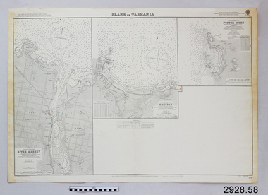
Document - Navigation Chart, Plans in Tasmania - Foster Inlet, River Mersey and Emu Bay
Navigation Chart - Plans in Tasmania - Foster Inlet, River Mersey and Emu Baywarrnambool, shipwrecked-coast, flagstaff-hill, flagstaff-hill-maritime-museum, maritime-museum, shipwreck-coast, flagstaff-hill-maritime-village, shipwrecked-artefact, river mersey, foster inlet, emu bay, navigation chart -
Ringwood and District Historical Society
Pamphlets, N.R. Reid & Co Pty Ltd, Subdivision pamphlet Hunter Estate Ringwood, 1959
The Hunter Estate, from Wonga Road to Mullum Mullum Road including Panfield Avenue, Hunter Avenue and Hendra Grove.Bifold pamphlet green black and white printing, plan of subdivision on second page -
 Glen Eira Historical Society
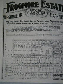
Frogmore Estate
Photocopy of sub division plan of Frogmore Estate in Murrumbeena and Carnegie, date unknownmurrrumbeena, carnegie, frogmore estate, land subdivision -
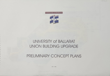 Federation University Historical Collection
Plan, University of Ballarat Union Building Upgrade Preliminary Concept Plans, November 1998, 11/1998
University of Ballarat is a predecessor of Federation UniversitySpiral bound Plans for University of Ballarat Union Building Upgrade Nov 1998union building upgrade, university of ballarat, preliminary concept plans, union building, albert coates building, mount helen campus, building, u building -
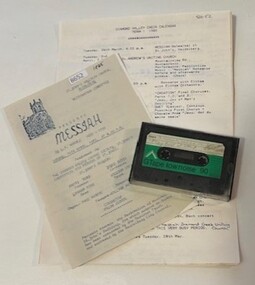 Greensborough Historical Society
Mixed media - Audio Cassette and Program, Diamond Valley Choral Society, Handel's Messiah, performed by Diamond Valley Choral Society 1983-1993, 14/04/1985
A recording of 'Messiah', an English language oratorio by George Frederic Handel, composed in 1741. The text was compiled from the King James Bible; it contains 3 parts and part 2 ends with the 'Hallelujah' chorus. This performance by the Diamond Valley Choral Society and combined choirs was recorded at St John's Church of England, Heidelberg 14/04/1985 (date on program).1 audio cassette in clear plastic case, planning notes and printed programHandwritten on case: "DVCS 1983-1993 for CD"diamond valley choral society, messiah (oratorio), st john's church of england heidelberg -
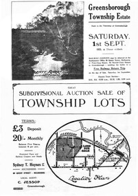 Greensborough Historical Society
Plan - Digital Image, Greensborough Township Estate, 01/09/1923
Sub-division into 129 lots of land belonging to the Scotland Family, bounded by William Street, Eliza Street, James (Jessop) Street and south of Lorimer Street. Auction 1 September 1923Digital copy of plan. Has been digitally corrected from damaged original.subdivision plans, greensborough township estate, scotland family -
Glenelg Shire Council Cultural Collection
Plan - Plan - Portland, Victoria, n.d
Plan of Portland, compiled and drawn by T.E.C. Henry, Assistant Surveyor, Nov. 1893 -
 City of Moorabbin Historical Society (Operating the Box Cottage Museum)
Document,photocopy plan 'Two Acre Village 'c1852, c1960
In the 1852 Josiah Holloway, a developer, purchased 625 acres from the squatters Richard and John King and sectioned '2 acre allotments' south of Henry Dendy's Brighton Survey along the Arthur's Seat Road ( later Nepean Highway) for sale @ £10 It became known as The Two Acre Village as settlers took up the allotments and established market gardens, general stores, butchers, blacksmiths, post office and 2 hotels. Charles Whorral opened The Cheltenham Inn and it became so popular as a meeting place that the area was called Cheltenham. The early settlers, who were predominantly English and Scottish immigrants initially leased their allotments and, because the sandy soil was so fertile, they were soon able to purchase the land and increase their acreage. Cheltenham became a very important part of the large Moorabbin Shire1871 and City of Moorabbin 1934 In the 1994 Amalgamation of Councils, when the large City of Moorabbin was divided between the newly formed Glen Eira, Kingston and Bayside Councils, the Cheltenham area was assigned to the City of Kingston A photocopy of the Plan for the 2 Acre Village in Moorabbin Parish c1852. A3 laminatedmoorabbin, brighton, cheltenham, market gardeners, pioneers, early settlers, , king. john, holloway josiah, whorral charles, arthur’s seat road, nepean highway , cheltenham inn hotel, henry dendy special survey 1841 -
4th/19th Prince of Wales's Light Horse Regiment Unit History Room
Book, Halstead Press Limited, Australian War Memorial, 7/1945
Guide to the Australian War Memorial as at 1945Hard cover book, 114 pp, including fold out plans of the memorialhistory, guide, australian war memorial -
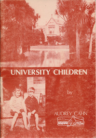 Eltham District Historical Society Inc
Book, University children / by Audrey Cahn, 1987
Audrey Cahn (nee Osborne) was from a local pioneer familyPaperback ; 66 p. : ill., ports. ; 25cm. Cover title. Plans on endpapers.Includes letter dated 4 Mar 1988 from author presenting the book to EDHS university of melbourne -
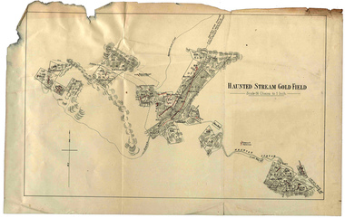 Federation University Historical Collection
Plan, Haunted Stream Gold Field
Plan of the Haunted Stream Gold Field - scale 16 chains to 1 inchhaunted stream, plan, battery -
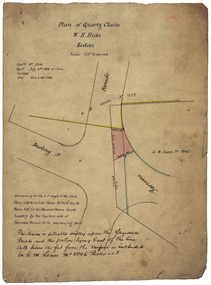 Federation University Historical Collection
Plan, Quartz Claim by W.H. Hicks, 1888, 1888
The quartz claim was made by W.H. Hicks in 1888.Hand coloured plan showing the area around Darling Street Redan (Ballarat). hicks, redan, yarowee parade, darling street, quartz claim -
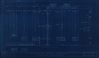
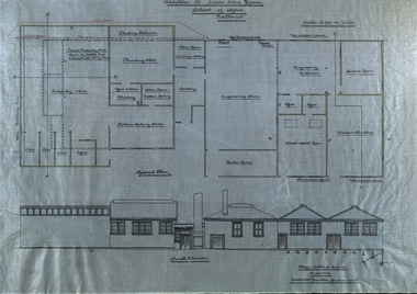 Federation University Historical Collection
Plan - Plans, Ballarat School of Mines Plans for the Additions to Trades Class Rooms
Born in Ballarat, George William Clegg F.R.V.I.A. was articled to Tappin, Gilbert and Dennehy who had architectural offices in Melbourne, Sydney and Ballarat, from 1885-1889. Clegg formed a partnership with Gilbert who ran the Ballarat Office and later with Kell and Miller. This eventually became Clegg and Miller, then Clegg Miller and Morrow, and finally Clegg and Morrow (1916). From about 1907 up until his resignation in 1918 Clegg taught Architecture and Building Construction at the Ballarat School of Mines. From 1918 he pursues interests in the Eureka Terracotta and Tile Company.Two plans on linen, relating to additions in the trade classrooms at the Ballarat School of Mines.ballarat school of mines, george clegg, george william clegg, george w. clegg, clegg, miller and morrow, trades, architecture, buildings -
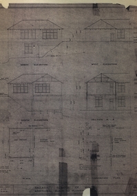 Federation University Historical Collection
Plan, Ballarat School of Mines Plumbing Building additions, 1948, 1948
Copy of plans showing elevations for additions to the Ballarat School of Mines Plumbing Shopballarat school of mines, plumbing, architectural plan -
 Federation University Historical Collection
Plan, Ballarat School of Mines Chemistry Laboratory Plan, 10/11/1950
Four blue line plans relating to the Ballarat School of Mines Chemistry Laboratory.ballarat school of mines, chemistry, laboratory, percy everett, old chemistry building -
Federation University Historical Collection
Plan - Engine, Bristol Proteus 705 Propeller Turbine, unknown
Unframed printed plan of internal workings of Bristol Proteus 705 Propeller Turbine. Made by Bristol Aero Engines Ltd. Technical Publication Department. Filton. Bristol. England. T.P. 2175 -
 Federation University Historical Collection
Plan, Plan of the Ballarat and Sebastopol Gold Mines
Coloured plan of the Ballarat and Sebastopol mines. Includes streets. Scale is 1:23,760robert allan, plans, cgt, ballarat, sebastopol, leviathan gold mining company, gold mines, gold companies, gold mining company -
 Federation University Historical Collection
Report, Ballarat School of Mines Research Proposal Report, 1980, 06/1980
Report from the Ballarat School of Mines on a research proposal. Planning Document 4.80ballarat school of mines, j.l. turner, planning document, curicula, low achievers -
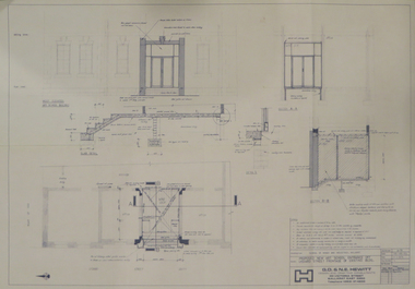 Federation University Historical Collection
Plan, Proposed New Art School Entrance off Lydiard Street Frontage of Existing Building, 1979, 1979
Plan of a new entrance for the Ballarat School of Mines Technical Art School Building. ballarat technical art school, ballarat school of mines, g.d. and n.e. hewitt, architectural plan -
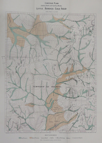 Federation University Historical Collection
Map - Report, H.S. Whitelaw, Report on the Little Bendigo or Nerrina Gold-Field, Ballarat, 1901, 1901
Blue soft covered book. Includes Contour plan of the Little Bendigo Goldfieldlittle bendigo, nerrena, nerrina, h.s. whitelaw -
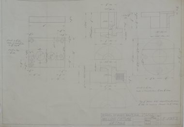
Federation University Historical Collection
Plan - Plans, Barkly Street Girls' School Sewerage Plans, c1952
Two hand coloured sewerage plans .1) Barkly Street .2) as aboveplans, sewerage plans, percy everett, barkly street, ballarat east, girls' school