Showing 2821 items
matching residence
-
 Surrey Hills Historical Society Collection
Work on paper - Photograph, Nethercourt Private Hospital, Surrey Hills, c 1924, 1924
Notes from a previous collection coordinator indicate that Miss Lucy Musselwhite (Lillywhite) opened the hospital in 1914 and Matron Eliza Tank took it over in 1921 and named it Nethercourt Private Hospital. However recent research suggests that Miss Musselwhite (name confirmed) moved from Tooronga to Wilson Street some time between 1903 and 1909. She and her mother Elizabeth are listed in the 1909 electoral rolls in Wilson Street and Lucy's occupation is given as nurse. (It is of course possible that the property was a residence only at this time and later opened as a private hospital.) The name Nethercourt was used prior to Matron Eliza Tank taking over. Her daughter Irene was also a nurse at Nethercourt. Lucy Musselwhite was born in 1873 in Hampshire. She married Henry James Dore in later life and lived in Brenbeal Street, Balwyn. She died in 1955. In 1930 / 1935 Matron Tank transferred the hospital to 219-223 Union Road. Later it was known as Norwich Hall / St Jude's. Mosgiel Hospital in Mont Albert Road also opened in 1924. After this time home births became less common. Nethercourt Hospital closed in the 1960s.Small hospitals such as this one were primarily used for midwifery, preceding the development of larger centralised general hospitals. Black and white photo of Nethercourt Private Hospital at 11 Wilson Street in c 1924 taken from the street in winter. The building is Victorian in style; block-fronted with lacework detail to the verandah and has 2 chimneys. It is set behind a wooden picket fence behind which is a well-manicured hedge which appears to have been grown across the front entrance gate.nethercourt private hospital, midwifery, hospitals, matron eliza tank, miss lucy musselwhite, miss irene tank, mrs irene anderson -
 Surrey Hills Historical Society Collection
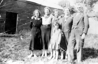
Photograph, McPhie family at back of Mounted Police Station, 5 Suffolk Road, Surrey Hills
"Sgt. David McPhie and some of his family/at Suffolk Road Mounted Police Station./Stables are shown in background./Courtesy - Mrs. P. Scales (nee McPhie)." The police established a station at 5 Suffolk Road in 1889. The first policeman was Constable Patrick Healey soon after assisted by Sgt Wilson. Constable David McPhie (1887-1963) was married to Jessica Beatrice McErvale (1891-1962) in 1914. They had a son - Angus (1916-1971) and a daughter Jean Cameron (1918-1985); she was born in Surrey Hills. In 1919 electoral rolls David McPhie is listed as a policeman at 5 Suffolk Road. Police gazettes list him as discharged on 2/11/1923. The family continue to live at 5 Suffolk Road and thereafter he is listed as a labourer. Entry in 'Surrey Hills In Celebration of the Centennial 1883-1983' states there was a mounted troopers' station at 5 Suffolk Road from 1889-1914. It was later at 5 Essex Road and then in 1923 moved to 171 Union Road (later the doctor's surgery and residence) and then to 93 Union Road where it stayed until 1947. It is not known how the donor was related to David McPhie.Image of a man, identified as Sgt. David McPhie, with five female members of his family, standing in front of the stables of the Mounted Police Station at 5 Suffolk Road, Surrey Hills.people, families, family groups, police, policemen, surrey hills mounted police station, horses, stables, suffolk road, david mcphie, miss jessie beatrice mcervale, mrs jessie beatrice mcphie -
 Surrey Hills Historical Society Collection
Photograph, 14 Albany Crescent, Surrey Hills
The house was built in 1927. It was the home of Mrs Fanny Harcourt (nee Horsfield), 1874-1949, who was the mother of Muriel Joy Harcourt. She married Alfred Leonard Gordon Noack in 1942. It later became their home. Alfred was a teacher and came to Surrey Hills from Echuca. Alfred Noack took a number of photos of the Surrey Hills area which he donated to the collection. Fanny Adelaide Harcourt Horsfield died in 1949 in Echuca. OBITUARY - MRS. F. A. HARCOURT-HORSFIELD The late Fanny Adelaide Harcourt-Horsfield, who passed away at her daughter's Mrs A. Noack's residence on July 26, was a member of the well-known Smythe family of Ballina, N.S.Wales, and the wife of the late Joseph Victor Harcourt-Horsfield executive member of the Nestle Anglo-Swiss Milk Coy. Deceased had been an invalid for some 15 years, but in spite of her disabilities was always of a bright and cheerful disposition, which endeared her to her many friends. Her remains were interred privately in the family grave at Heidelberg. The Rev. H. W. R. Norwood officiated at the graveside. REF: Trove - The Riverina Herald, 28 July 1949. Black and white photo of 14 Albany Crescent, Surrey Hills. It is a Californian bungalow with a tiled roof and wood and lattice fence. The road and footpath appear to be unmade. There is a man standing behind the fence and a young girl is sitting on the fence on the RHS. Parts of the houses to the left and behind are visible. There is a mature tree growing in the unmown nature strip. californian bungalows, albany crescent, (mrs) fanny harcourt, (mrs) fanny harcourt-horsfield, muriel joy harcourt, muriel joy noack, muriel noack, alfred noack, alfred leonard gordon noack -
 Bacchus Marsh & District Historical Society
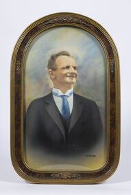
Painting, Portrait of Thomas Manly, 1930
Thomas Manly was a well-known resident of Bacchus Marsh. Born at Rowsley in 1863, Mr. Manly was a grandson in a family who had been in the service of the Greene family at "Greystones" from the time of its arrival in Victoria. The woolsheds at "Greystones" were built by deceased's grandfather, who also conducted a jeweller's shop at Rowsley. Like his forebears, Mr. Thomas Manly entered the service at "Greystones" and later worked for Messrs. Chomley and Boyd at "Glenmore." After his marriage to Miss Mary Johnston, whose mother arrived as an infant in Bacchus Marsh as early as 1839, Mr. Manly took up residence in the Main Street, Bacchus Marsh, where he has lived ever since. Deceased was a great walker, and mostly walked to his work, both at Rowsley and for the past 27 years to the Darley brickworks. Never a prominent man in public affairs, he was essentially a home-lover, and adopted horticulture as his hobby, gaining many prizes for both flowers and lucerne. Text for this description taken from the obituary for Thomas Manly in the Bacchus Marsh Express, 26 June, 1937, page 3, column 2.A framed painting based on a 1930 photograph of Tom Manly.'Heirloom' inscribed at the bottom right hand corner of the paintingthomas manly 1863-1937, bacchus marsh and district biographies -
 Parks Victoria - Cape Nelson Lightstation
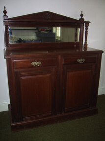
Furniture - Sideboard
The cedar sideboard has two cupboard doors below two corresponding drawers. The style is in keeping with the completion date of the lightstation in 1884, when furniture in the late nineteenth century had squarer, more defined lines and angles, and ornamental features. This sideboard is a modest version of this trend combining a pediment‐shaped back board with turned side columns and finials, rectangular mirror, decorative drawer pulls and door handle, as well as cupboards and drawers with bevelled, raised panels. The initials ‘PWD’along with a crown motif and letters are inscribed on the side indicating that the furnishing was the property of the government and made in its workshops. The Public Works Department, which operated in Victoria from 1855 to 1987, was responsible for the design of Victoria’s major public buildings and provision of furnishings to its offices as well as residences where the need was required.301 The keepers’ quarters at Cape Otway Lightstation were supplied with two of the same sideboards, which remain there today; on is intact (COLS 0001), the other missing the backboard (COLS 0015). Two similar but plainer examples, which are probably earlier in date, also remain at Cape Schanck (CSLS 0007.3; CSLS 0009.3). The Cape Nelson sideboard has first level contributory significance as a fine example of the good quality domestic furnishings made by the Victorian Government and provided to lighthouse keepers and their families in the late nineteenth century. It is also significant for its provenance to the lightstationThe cedar sideboard has two cupboard doors below two corresponding drawers with pediments‐shaped back board with turned side columns and finials, a rectangular mirror, decorative drawer pulls and door handle, as well as cupboards and drawers with bevelled, raised panels. -
 Melbourne Legacy
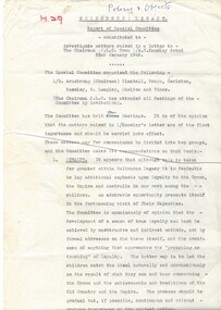
Document, Report of Special Committee (H29), 1948
A special committee was convened to investigate matters raised by Legate A N Kemsley (Chairman of JLC) in a letter dated 22 January 1948. The committee comprised of Legatees Armstrong (Chairman), Blackall, Brain, Carleton, Kemsley, G Langley, Sheldon, and Vines. The matters were addressed in two groups, Loyalty and Training in Good Citizenship. Loyalty: recommendations included a framed photo of the King and Queen is displayed in all residences and rooms where classes were conducted; that a simple declaration of loyalty be recited as part of classes; that the Union Jack and Australian flag be displayed in all rooms where classes are held (flags would need to be procured as their present stock as 'small and in poor order'; that the offer to borrow items from the UK Information Office about the Royal family be accepted; that Anzac Day and the Shrine of Remembrance be discussed prior to Anzac Day at classes held in March and April; that Junior Legatees be encouraged to attend Legacy Ceremony at the Shrine on Anzac Day. Training in good citizenship: to use the Legacy camps to impress on the juniors aspects of appropriate behaviour and attitudes. The notation H29 in red pen shows that it was part of the archive project that was trying to capture the history of Legacy. A record of Legatees making recommendations about loyalty and behaviours to instil in junior legatees.White foolscap paper with black type x 4 pages about a special committee.Handwritten H29 in red pen and 'Policy and Objectives' in blue pen.history, regulations, rules -
 Melbourne Legacy
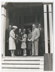
Photograph, Moorlands, 1947
The photo shows a small girl presenting a bunch of flowers to Lady Lavarack on the steps of Moorlands. The Queensland Governor Sir John Lavarack and his wife were attending the opening of the Legacy childrens' residence, Moorlands, in Brisbane on 20 February 1947. Legatee Stan Savige had travelled to Brisbane for the event, he is at the centre rear. From TROVE: Telegraph (Brisbane, Qld. : 1872 - 1947), Tuesday 18 February 1947, page 7 FOR OPENING OF LEGACY HOME Lieutenant-General Stan Savige (left) arrived in Brisbane this afternoon to attend the opening of the new Legacy home, Moorlands, at Coronation Drive. On the right is Mr. F. E. Lascelles, Brisbane president of Legacy. Moorlands will be opened by the Governor (Sir John Lavarack) on Thursday. Moorlands is a heritage-listed villa at 451 Coronation Drive, Auchenflower, Queensland, Australia. It was designed by Richard Gailey and was built c. 1892 by contractor Arthur Smith. It was added to the Queensland Heritage Register on 21 August 1992. In 1947 the building was sold to the Brisbane branch of the Legacy War Widows and Orphans Fund, and accommodated war-orphaned children and widows until 1971.Some Legacy events were attended by dignitaries, such as the State governors' and their wives and the events were covered by press photographers and reported in newspapers.Black and white photo of a girl presenting flowers to the Queensland Governor's wife at Moorlands.Handwritten 'Complements from J D Coots(?)' in pencil. Stamped with copyright of 'The Telegraph Feature Service Brisbane', in purple ink.residences, moorlands -
 Ballarat Heritage Services
Photograph - Digital photograph, Nose in Admiralty Arch, London, 19/09/2016
Admiralty Arch is a landmark building in London which incorporates an archway providing road and pedestrian access between The Mall, which extends to the southwest, and Trafalgar Square to the northeast. Admiralty Arch, commissioned by King Edward VII in memory of his mother, Queen Victoria and designed by Aston Webb is now a Grade I listed building. In the past, it served as residence of the First Sea Lord and was used by the Admiralty. Until 2011, the building housed government offices, but in 2012 the government sold a 125-year lease over the building to a property developer (Prime Investors Capital, run by Rafael Serrano) for redevelopment into a luxury hotel, restaurant and apartments. (Wikipedia) On the inside wall of the northernmost arch is a small protrusion the size and shape of a human nose. It was placed there by artist Rick Buckley in 1997 as part of a campaign against the "Big Brother" society. The nose is at a height of about seven feet, and sits at waist height for anyone riding through the arch on a horse. Prior to Buckley being unmasked in 2011 by the London Evening Standard, an urban myth grew that the nose is there in honour of the Duke of Wellington, who was known for having a particularly large nose.(wikipedia)admiralty arch, london, nose -
 Kew Historical Society Inc
Photograph, Marnie McLeod, Floods of the River Yarra at Kew, 1916
The donation was accompanied by the following letter from the donor: "Hi. I found these in with family photos. Taken by family as Mamie McLeod was living in Fellows Street, Kew, so would be near there. Retain (or discard) as you see fit." [Donor's name and address withheld from public view]. To gain an insight into the flood levels at Kew, it is worth reading newspaper accounts of the event. The Age published an article - Valuable Gardens Destroyed at Kew - on 25 September 1916: "VALUABLE GARDENS DESTROYED AT KEW. From the heights of Studley Park, Kew, a splendid view of the flood waters can be obtained, and yesterday afternoon, despite continuous rain, crowds of citizens assembled there to witness the spectacle. There is a vast stretch of water some 300 or 400 yards broad, above the foot bridge connecting Gipps-street, Collingwood, and Studley Park. The river is only about 3 feet from the top of the embankment connecting with the ramp of the bridge on the Studiey Park side. When the upper llood waters come down it is almost a certainty that tne embankment will be submerged and the bridge rendered impassible. Below the bridge the waters again stretch out, and have submerged all the low-lying land on the Collingwood side and invaded the back premises ot the Kodak Co., Phoenix Biscuit Factory, a tannery adjoining thereto, the Shamrock Brewery, and Chinese gardens in the vicinity. At Walmer-street-bridge, at the end of Studley Park, the low-lying land on the Kew side is covered with water to the depth of many feet. Tlie land in question is owned in a great part by Mr Frank Lavers who haa gone in for intense culture on a pretty liberal scale on both the slopes of the hill and on the river flat. On the latter he is cultivating many acres of asparagus, and has at a considerable cost spent three years in preparing the ground and installing an irrigation system, reticulated from the Yan Yean water supply. This year the asparagus was put down, and the plants were in a promising condition. Tlie flood waters are now flowing fast over the land. The crop is ruined, and three years' work and expenditure destroyed. Mr. Laver's private residence fortunately is high above flood level, but two houses he owns off Young-street have been flooded out. Having been warned in time, the tenants removed their furniture hefore the water came down to Mr. Laver's residence, where they themselves have been given accommodation in the meantime. All the river flats in East Kew are under water. One or two low-lying houses have been flooded. Chipperfield's boat shed at Willsmere is nearly covered, and some Chinese gardens in the vicinity are several feet under water."This, and the other three photographs donated of floods in Kew are believed to be the earliest in the collection. Together with our original MMBW River Yarra map showing flood levels, these items, when compared allow researchers to gain a visual perspective of the extent of the flood in 1916. Black and white photograph of flooded trees in Kew with rising dry ground in distance.Inscription on reverse in pencil: "Flood River Yarra Kew Vic"river yarra, kew, floods 1916 -
 Kew Historical Society Inc
Photograph, Marnie McLeod, Floods on the River Yarra at Kew, 1916
The donation was accompanied by the following letter from the donor: "Hi. I found these in with family photos. Taken by family as Mamie McLeod was living in Fellows Street, Kew, so would be near there. Retain (or discard) as you see fit." [Donor's name and address withheld from public view]. To gain an insight into the flood levels at Kew, it is worth reading newspaper accounts of the event. The Age published an article - Valuable Gardens Destroyed at Kew - on 25 September 1916: "VALUABLE GARDENS DESTROYED AT KEW. From the heights of Studley Park, Kew, a splendid view of the flood waters can be obtained, and yesterday afternoon, despite continuous rain, crowds of citizens assembled there to witness the spectacle. There is a vast stretch of water some 300 or 400 yards broad, above the foot bridge connecting Gipps-street, Collingwood, and Studley Park. The river is only about 3 feet from the top of the embankment connecting with the ramp of the bridge on the Studiey Park side. When the upper llood waters come down it is almost a certainty that tne embankment will be submerged and the bridge rendered impassible. Below the bridge the waters again stretch out, and have submerged all the low-lying land on the Collingwood side and invaded the back premises ot the Kodak Co., Phoenix Biscuit Factory, a tannery adjoining thereto, the Shamrock Brewery, and Chinese gardens in the vicinity. At Walmer-street-bridge, at the end of Studley Park, the low-lying land on the Kew side is covered with water to the depth of many feet. Tlie land in question is owned in a great part by Mr Frank Lavers who haa gone in for intense culture on a pretty liberal scale on both the slopes of the hill and on the river flat. On the latter he is cultivating many acres of asparagus, and has at a considerable cost spent three years in preparing the ground and installing an irrigation system, reticulated from the Yan Yean water supply. This year the asparagus was put down, and the plants were in a promising condition. Tlie flood waters are now flowing fast over the land. The crop is ruined, and three years' work and expenditure destroyed. Mr. Laver's private residence fortunately is high above flood level, but two houses he owns off Young-street have been flooded out. Having been warned in time, the tenants removed their furniture hefore the water came down to Mr. Laver's residence, where they themselves have been given accommodation in the meantime. All the river flats in East Kew are under water. One or two low-lying houses have been flooded. Chipperfield's boat shed at Willsmere is nearly covered, and some Chinese gardens in the vicinity are several feet under water."This, and the other three photographs donated of floods in Kew are believed to be the earliest in the collection. Together with our original MMBW River Yarra map showing flood levels, these items, when compared allow researchers to gain a visual perspective of the extent of the flood in 1916. Panoramic view, believed to be looking north towards Fairfield from the Zig-Zag Bridge on the River Yarra. The inscription on the reverese identifies it as taken before 1920.Inscription on reverse in ink "(pre 1920) Flood from Zig-zag bridge Yarra River, Kew Vic."river yarra, kew, floods 1916, zig-zag bridge -
 Kew Historical Society Inc
Photograph, Marnie McLeod, Flood, River Yarra, Kew, 1916
The donation was accompanied by the following letter from the donor: "Hi. I found these in with family photos. Taken by family as Mamie McLeod was living in Fellows Street, Kew, so would be near there. Retain (or discard) as you see fit." [Donor's name and address withheld from public view]. To gain an insight into the flood levels at Kew, it is worth reading newspaper accounts of the event. The Age published an article - Valuable Gardens Destroyed at Kew - on 25 September 1916: "VALUABLE GARDENS DESTROYED AT KEW. From the heights of Studley Park, Kew, a splendid view of the flood waters can be obtained, and yesterday afternoon, despite continuous rain, crowds of citizens assembled there to witness the spectacle. There is a vast stretch of water some 300 or 400 yards broad, above the foot bridge connecting Gipps-street, Collingwood, and Studley Park. The river is only about 3 feet from the top of the embankment connecting with the ramp of the bridge on the Studiey Park side. When the upper llood waters come down it is almost a certainty that tne embankment will be submerged and the bridge rendered impassible. Below the bridge the waters again stretch out, and have submerged all the low-lying land on the Collingwood side and invaded the back premises ot the Kodak Co., Phoenix Biscuit Factory, a tannery adjoining thereto, the Shamrock Brewery, and Chinese gardens in the vicinity. At Walmer-street-bridge, at the end of Studley Park, the low-lying land on the Kew side is covered with water to the depth of many feet. Tlie land in question is owned in a great part by Mr Frank Lavers who haa gone in for intense culture on a pretty liberal scale on both the slopes of the hill and on the river flat. On the latter he is cultivating many acres of asparagus, and has at a considerable cost spent three years in preparing the ground and installing an irrigation system, reticulated from the Yan Yean water supply. This year the asparagus was put down, and the plants were in a promising condition. Tlie flood waters are now flowing fast over the land. The crop is ruined, and three years' work and expenditure destroyed. Mr. Laver's private residence fortunately is high above flood level, but two houses he owns off Young-street have been flooded out. Having been warned in time, the tenants removed their furniture hefore the water came down to Mr. Laver's residence, where they themselves have been given accommodation in the meantime. All the river flats in East Kew are under water. One or two low-lying houses have been flooded. Chipperfield's boat shed at Willsmere is nearly covered, and some Chinese gardens in the vicinity are several feet under water."This, and the other three photographs donated of floods in Kew are believed to be the earliest in the collection. Together with our original MMBW River Yarra map showing flood levels, these items, when compared allow researchers to gain a visual perspective of the extent of the flood in 1916. Small black and white photograph of flooded trees in Kew.Inscription on reverse in ink "Flood R. Yarra Kew Vicriver yarra, kew, floods 1916 -
 Federation University Art Collection
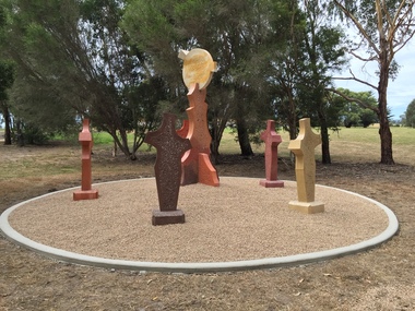
Sculpture, 'Mungo Moon' by Don Barrett, 2015
'Mungo Moon' by Don Barrett is the first sculpture erected on the Churchill Art and Culture Pathway. It was officially unveiled by Professor David Battersby on 15 April 2015 From Churchill & District News 16 October 2014 The Churchill Art and Culture Walking Pathway will have its official public opening on Saturday October 18, with a walk finishing at Federation University Australia’s Switchback Gallery at the Federation University Gippsland Campus. ... An important link on the newly developed pathway was recently completed with a path south of the FedUni Student West Residences. The path now allows walkers to turn off the Eel Hole Creek path before reaching Glendonald Estate and to follow a picturesque, tree lined walkway to join up with the footpath on the Eastern side of Northways Road. From there the footpath joins into Federation University’s network of walking paths that proceeds past the Switchback Art Gallery, down through the pine plantation and along Lake Kretlow and the Churchill Golf Course. Project Manager Mike Answerth, said the opening of the West Residences section of the path means there is now only one short link to complete. “We’re now very close to realising the project’s objective to join up all these walking paths to provide a continuous pathway that encompasses town, campus and parkland. The next stage of the project will be the completion of Latrobe City’s East West Link and the enhancement of the walking path with artistic and cultural features.” said Mr. Answerth. Head of Federation University Australia Gippsland Campus, Dr Harry Ballis, said the project had been made possible through the contributions of the five former Gippsland Education Precinct (GEP) partners. “The Art and Culture Pathway represents another important step in joining the Churchill township and the university campus as a physical and social entity,” Dr Ballis said. “This was an initiative of the GEP and it is pleasing to see it coming to fruition.” The path now reaches as far as the golf driving range but plans are already under way to connect with the Mathison Park board walk and pathway, which surrounds Lake Hyland in Churchill. When the loop is completed, residents and visitors will have an approximately 5km circular walking path which links up the Churchill town centre, Federation University Australia and Mathison Park. There are already art features along this route, including primary schools’ Bug Blitz totems near the Kurnai College school crossing, native vegetation and history panels near the Hare Homestead in Mathison Park, and outdoor sculptures in the pine trees near the Federation University Switchback Gallery. contemporaryA large sculpture in five pieces set in an external location. It is part of the Churchill Art and Culture Walking Pathway. Don Barrett’s work is mainly in concrete with added coloured oxides to portray the feeling of the Australian landscape. Barrett focuses on concepts of Australia’s short history and indigenous history. churchill art and culture pathway, barrett, don barrett, gippsland campus, federation university, churchill, sculpture -
 Melton City Libraries
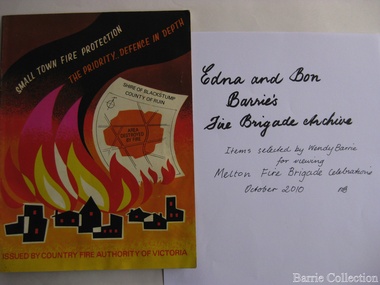
Archive, Edna and Bon Barries Fire Brigade Archives, 2010
In the 1950s with the introduction two-way HF and later VHF very high frequency radio sets. Melton Rural Fire Brigade was part of the Bacchus Marsh Group. Radio sets where located in the Melton Fire Truck, and in the house of the Barrie family at Ferris Road. This was an ideal location to observe a 360 degree view in all directions when smoke appeared on the horizon. An antenna was erected beside the house. The set OX 7 was located in the kitchen and monitored 24 hours by the family. When an electrical fire occurred at the junction of the electricity to the house there was time to radio the fire station and summons the men working in the paddocks, thus saving the house from possible destruction. With the introduction of UHF – ultra high frequency Vinten Radios the signal was clearer and static and interference lessened and radio traffic became easier to read, and reduced noise levels in the household. VL3 LY Radio Base became the Group Headquarters was established in 1967. By 1970 the Brigades were: Melton, Rockbank, Sydenham, Toolern Vale, Diggers Rest, Truganina, and Werribee. In 1974 when the family moved to First Avenue, another antenna and a small building were erected adjacent to the residence and used to house the equipment, maps. Radio traffic consisted of regular schedule times and communication with adjoining groups of brigades such as Bacchus Marsh, Mt Macedon and Little River Groups. Many of the brigade and group base radios were situated in private residences and operated primarily by fire fighters wives who held the position of Communications Officer, either registered as a brigade member or informally. Edna was never registered as an operational brigade member but operated informally as an assistant to her husband Bon. She was however a member of the Melton Fire Brigade Ladies Auxiliary from its inception in 1968, a non-operational position. Edna kept up to date with radio procedure following the 1967 handbook; preparing maps, plotting compass points and taking notes on weather forecasts from the SA Border and Western District. Daily notes were taken in anticipation of fire warnings. These log books and daily radio traffic were incidental to the regular radio schedules. Emergency turnouts noted, burning off times and predicted location of smoke. In the summer fire season all TBF (total fire ban days were recorded.) In times of emergency the Barrie family assisted Bon the base radio operator to plot the position and location of fire trucks and to help clarify garbled radio traffic, keep notes and make telephone calls. These log books are held in the EE and EW Family Archive. Items selected by Wendy Barrie for viewing Melton Fire Brigade celebrationsemergency services, local identities -
 Eltham District Historical Society Inc
Photograph - Digital Photograph, Alan King, Panton Hill Primary School, 27 March 2008
The Panton Hill Primary School building, which has served the community since 1889, was not the area's first. Kingston School (an early name for Panton Hill) opened in May 1865. This was replaced in 1871 when the Panton Hill School number 1134 opened and in 1874 the school moved to its current location [September 2023] where many additions and renovations have taken place to meet the needs of local children in the 21st century. Covered under Heritage Overlay, Nillumbik Planning Scheme. Published: Nillumbik Now and Then / Marguerite Marshall 2008; photographs Alan King with Marguerite Marshall.; p63 The Panton Hill Primary School building, which has served the community since 1889, was not the area’s first. In 1871 Henry Edelman opened a Common School in a paling-clad hut, replacing the Kingstown No 786 school. The two-acre (0.8ha) site of crown land had previously been held under Miners Right. In 1875 the Education Department bought a building on the main road for State School No 1134, for £200 and remodelled it as a school.4 Panton Hill had as one of its teachers, Frank Tate, who was to become one of Victoria’s most influential educational reformers. It was his first school, when he began teaching on January 22, 1884, as a 20 year old.5 The following month Robert J Harris was appointed to the school and remained as head teacher until his death in 1887. His son R C Harris was apprenticed to Mr Rossiter, editor of the first local paper. The Evelyn Observer, first published in 1873. Harris later bought the newspaper which remained a family business until the 1920s. J Hughes of Cherry Tree Road succeeded Harris as teacher at Panton Hill and sold his land for the school site. Though now unrecognisable, the school building includes the classroom of the last Smiths Gully State School No 1737, which was built in 1882, and moved to Panton Hill in 1894. From 1922 each school day began with the ringing of the bell, which is still in its stand, and is an unusually old memorial of this kind. To accommodate the growing population, the building was remodelled, with additions in 1923 and classrooms were added in 1955, 1963 and 1970. The former teacher’s residence is the only surviving 19th century dwelling in the centre of Panton Hill, and is now used as part of the school. The residence was originally rectangular but is now L-shaped. Similar weatherboard State School buildings in the shire from this period are the Kangaroo Ground and the St Andrews Primary Schools. All were standard Education Department/Public Works Department designs.This collection of almost 130 photos about places and people within the Shire of Nillumbik, an urban and rural municipality in Melbourne's north, contributes to an understanding of the history of the Shire. Published in 2008 immediately prior to the Black Saturday bushfires of February 7, 2009, it documents sites that were impacted, and in some cases destroyed by the fires. It includes photographs taken especially for the publication, creating a unique time capsule representing the Shire in the early 21st century. It remains the most recent comprehenesive publication devoted to the Shire's history connecting local residents to the past. nillumbik now and then (marshall-king) collection, panton hill primary school -
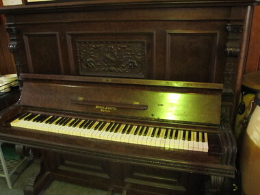 Mission to Seafarers Victoria
Instrument - Piano, Upright, c.1905
The piano (Beale-Vader patented model) was donated on Thursday 19 December 1907 by Lady Northcote (Alice, wife of the Governor General of Australia) for the Siddeley Street Institute. The article in The Age dating Friday 20 December 1907: "Shortly after noon yesterday the Rey. A. Gurney Goldsmith, chaplain to the Victorian Missions to Seamen, who has just taken up residence at his quarters in the new Seamen's' Institute on the Yarra-bank, which was recently opened by his Excellence the Governor-General, was surprised at the receipt of a case of large dimensions. On opening it he found a grand piano, accompanied by a card, "With Lady Northcote's compliments." The pianoforte is one of Beale's make, and its presentation is another illustration of the determination of the vice-regal representatives in Australia to encourage local manufactures. It will be remembered that on the occasion of the opening of the institute an appeal was made to the public for a pianoforte and a billiard table. Lady Northcote has responded with the former, and it will be most useful in connection with the concerts which are given once a week to the, sailors of vessels coming up tho river. The question now arises as to who will provide the billiard table for the use of "Jack ashore," as one of the inducements for him, to visit the institute instead of' spending his spare time in the public house. "Governor Northcote and his wife had laid the foundation Stones of the first Central Institute on Siddeley street. The piano was used it for entertainments and concerts including accompaniment of silent films in the 1920s. 21st century visiting seafarers whilst on shore at the Mission, still regularly play pieces such as popular tunes and classics. A walnut case, full iron framed Upright Piano . See image details; decorative trims throughout, and identification plate inside. Screw holes indicate missing candle brackets or sconces on the two front panels.Lid Royal letters patent coat of arms; inside workings stamped plaque: " The/ Beale-Vader / Steel-wirest-plank / patented / throughout / the world"piano, royal grand piano, beale, beale-vader, music, entertainment, concerts, lady northcote, siddeley street, seamen's mission, alice northcote nee stephen, reverend alfred gurney goldsmith -
 Eltham District Historical Society Inc
Photograph - Digital Photograph, Alan King, Wellers Restaurant, 150 Eltham-Yarra Glen Road, Kangaroo Ground, 23 January 2008
Originally Wellers Hotel, it was constructed by Edward Weller in 1872. Following his death in 1883 it was taken over by his widow, Mary Weller. The hotel was delicensed in 1909 and converted to a private residence. Around 1920 William Pitman bought the property, succeeded by his son Vernon who coined the term Pittman's Corner. Vernon and Isabel Pitman owned the house form 1945-1973. Following Vernon's death, Isabel remained there till her death in 1983. The property was converted to a restaurant in 1984 by owners Robert and Kath Hendry who undertook extensive renovations in 1988. Shawn and Stephanie Wolfe purchased the property from the Hendrys in 2003 and introduced live entertainment with many famous bands and entertainers from the 1960s, 1970s and 1980s performing there, including James Reyne, Daryl Barithwaite, Brian Cadd and Billy Thorpe. In 2014 the Wolfe's sold the property and the entire contents were sold at auction. New (local ) owners Gregory Anderson, Craig Jones and Steve Gist refurbished the property and relaunched it as Fondata 1872 in 2017. Covered under Heritage Overlay, Nillumbik Planning Scheme. Published: Nillumbik Now and Then / Marguerite Marshall 2008; photographs Alan King with Marguerite Marshall.; p87This collection of almost 130 photos about places and people within the Shire of Nillumbik, an urban and rural municipality in Melbourne's north, contributes to an understanding of the history of the Shire. Published in 2008 immediately prior to the Black Saturday bushfires of February 7, 2009, it documents sites that were impacted, and in some cases destroyed by the fires. It includes photographs taken especially for the publication, creating a unique time capsule representing the Shire in the early 21st century. It remains the most recent comprehenesive publication devoted to the Shire's history connecting local residents to the past. nillumbik now and then (marshall-king) collection, eltham-yarra glen road, fondata 1872, kangaroo ground, wellers restaurant, billy thorpe, brian cadd, craig jones, daryl barithwaite, edward weller, gregory anderson, hotels, james reyne, kath hendry, mary weller, restaurants, robert hendry, shawn wolfe, stephanie wolfe, steve gist -
 Glen Eira Historical Society
Article - Third Church of Christ, Scientist, Elsternwick
5 Articles about the building which used to be Third Church of Christ, Scientist Elsternwick. The first one is an article from leader newspaper dated 27 July 2010 discussing the plan to convert former Christian Science Church and latterly Buddhist organisation into apartments. The second article is from Leader Newspaper dated 10 August 2010, commenting on disruptions that might occur with redevelopment. Third article is from Caulfield Leader, 07/09/2010. The article is on continuing discussion on proposed plans for the building which previously was a historic church. Also mentioned, residence’s concern and complains about the plan. The fourth article from Caulfield/ Port Phillip Leader, 24/05/2011, mainly talks about similar development at 221 -229 Glen Huntly Road. It also touches the subject of 233 – 147 Glen Huntly Road and 12 – 14 Ripon Grove as well. It is written that VCAT allowed the development of 10 storey building after overturning council decision. The fifth article is from Melbourne Bayside Weekly, 28/03/2012. It talks about the history of The Church of Christ, Scientist and about the old church building that still stands.ripon grove, gordon street, contour consultant, glen eira, historic sites, buddhist clubs and associations, elsternwick, glen huntly road, church, wait peter, wright kristen, kate ms, sinclair street, soka gakkaii, local government, local officials and employees, mc combie street, david street, ward camden, holden lars., connellan rose, connellan cathlea, connellan marilyn, third church of christ scientist elsternwick, heritage victoria, victorian civil and administration tribunal, eddy mary baker, clifton andrew, sammon jason, di paolo lucy, robinson andrew, ling jenny, church of christ scientist -
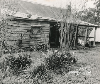 Eltham District Historical Society Inc
Photograph, George W. Bell, Birch Cottage, Yarra Glen Road, Smiths Gully, Aug 1969, Aug 1969
EDHS Newsletter No. 182, September 2008 In the late 1970s when our Society was the Shire of Eltham Historical Society, an offer was made to the Society regarding use of an old cottage at Christmas Hills. For various reasons the offer ultimately lapsed The cottage sat beside Watsons Creek just outside the then Shire of Eltham but following municipal restructuring it now lies within the Shire of Nillumbik. At that time some research on the cottage was carried out for the Society by Keith Chappel as part of a larger research project that he was doing. Keith's notes were taken from Lands Department records and showed that house is the subject of a permissive occupancy of Crown land comprising the creek reserve. In 1903 a Miners Right of one acre in area was granted to Edwin Samuel Birch. In 1907 Birch applied to purchase this land but was unable to because it was part of the creek reserve. The documents show that the house existed at that time. Birch died in 1932 and his daughter Honor Mary Birch was granted a permit to occupy the residence. The future of the cottage remains precarious because of its location on Crown land. In 2007 the Andrew Ross Museum began a campaign to ensure that it is preserved. It included a video presentation on the history of the cottage under the title of "This Old House- Birch Cottage". Black and white photographWilliams Cottage Panton Hill 1969 Not to be reproduced without permission G.W. Bell Photographer Elthamhouses, cottage, early settlers, yarra glen road, smiths gully, williams cottage, watsons creek, christmas hills, birch cottage, edwin samuel birch, honor mary birch -
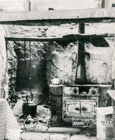 Eltham District Historical Society Inc
Photograph, George W. Bell, Detail, Kitchen, Birch Cottage, Yarra Glen Road, Smiths Gully, Aug 1969, Aug 1969
EDHS Newsletter No. 182, September 2008 In the late 1970s when our Society was the Shire of Eltham Historical Society, an offer was made to the Society regarding use of an old cottage at Christmas Hills. For various reasons the offer ultimately lapsed The cottage sat beside Watsons Creek just outside the then Shire of Eltham but following municipal restructuring it now lies within the Shire of Nillumbik. At that time some research on the cottage was carried out for the Society by Keith Chappel as part of a larger research project that he was doing. Keith's notes were taken from Lands Department records and showed that house is the subject of a permissive occupancy of Crown land comprising the creek reserve. In 1903 a Miners Right of one acre in area was granted to Edwin Samuel Birch. In 1907 Birch applied to purchase this land but was unable to because it was part of the creek reserve. The documents show that the house existed at that time. Birch died in 1932 and his daughter Honor Mary Birch was granted a permit to occupy the residence. The future of the cottage remains precarious because of its location on Crown land. In 2007 the Andrew Ross Museum began a campaign to ensure that it is preserved. It included a video presentation on the history of the cottage under the title of "This Old House- Birch Cottage". Black and white photographWilliams Cottage Panton Hill 1969 Not to be reproduced without permission G.W. Bell Photographer Elthamhouses, cottage, early settlers, yarra glen road, smiths gully, williams cottage, watsons creek, christmas hills, birch cottage, edwin samuel birch, honor mary birch -
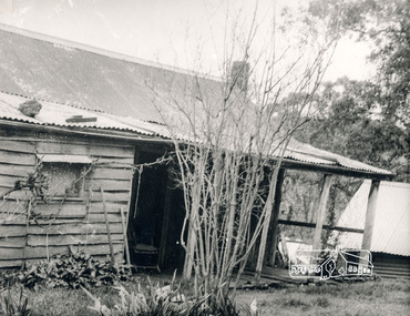 Eltham District Historical Society Inc
Photograph, George W. Bell, Detail, Cottage Entrance, Birch Cottage, Yarra Glen Road, Smiths Gully, Aug 1969, Aug 1969
EDHS Newsletter No. 182, September 2008 In the late 1970s when our Society was the Shire of Eltham Historical Society, an offer was made to the Society regarding use of an old cottage at Christmas Hills. For various reasons the offer ultimately lapsed The cottage sat beside Watsons Creek just outside the then Shire of Eltham but following municipal restructuring it now lies within the Shire of Nillumbik. At that time some research on the cottage was carried out for the Society by Keith Chappel as part of a larger research project that he was doing. Keith's notes were taken from Lands Department records and showed that house is the subject of a permissive occupancy of Crown land comprising the creek reserve. In 1903 a Miners Right of one acre in area was granted to Edwin Samuel Birch. In 1907 Birch applied to purchase this land but was unable to because it was part of the creek reserve. The documents show that the house existed at that time. Birch died in 1932 and his daughter Honor Mary Birch was granted a permit to occupy the residence. The future of the cottage remains precarious because of its location on Crown land. In 2007 the Andrew Ross Museum began a campaign to ensure that it is preserved. It included a video presentation on the history of the cottage under the title of "This Old House- Birch Cottage". Black and white photographDetail Cottage Entrance Williams Cottage Yarra Glen Rd Panton Hill Aug 1969 Photo - G.W.Bhouses, cottage, early settlers, yarra glen road, smiths gully, williams cottage, watsons creek, christmas hills, birch cottage, edwin samuel birch, honor mary birch -
 Eltham District Historical Society Inc
Photograph, George W. Bell, Detail, Front Wall, Birch Cottage, Yarra Glen Road, Smiths Gully, Aug 1969, Aug 1969
EDHS Newsletter No. 182, September 2008 In the late 1970s when our Society was the Shire of Eltham Historical Society, an offer was made to the Society regarding use of an old cottage at Christmas Hills. For various reasons the offer ultimately lapsed The cottage sat beside Watsons Creek just outside the then Shire of Eltham but following municipal restructuring it now lies within the Shire of Nillumbik. At that time some research on the cottage was carried out for the Society by Keith Chappel as part of a larger research project that he was doing. Keith's notes were taken from Lands Department records and showed that house is the subject of a permissive occupancy of Crown land comprising the creek reserve. In 1903 a Miners Right of one acre in area was granted to Edwin Samuel Birch. In 1907 Birch applied to purchase this land but was unable to because it was part of the creek reserve. The documents show that the house existed at that time. Birch died in 1932 and his daughter Honor Mary Birch was granted a permit to occupy the residence. The future of the cottage remains precarious because of its location on Crown land. In 2007 the Andrew Ross Museum began a campaign to ensure that it is preserved. It included a video presentation on the history of the cottage under the title of "This Old House- Birch Cottage". Black and white photographDetail of Front Wall Williams Cottage Yarra Glen Rd Panton Hill Aug 1969 Photo - G.W.Bhouses, cottage, early settlers, yarra glen road, smiths gully, williams cottage, watsons creek, christmas hills, birch cottage, edwin samuel birch, honor mary birch -
 Eltham District Historical Society Inc
Photograph, George W. Bell, Detail, Shed Wall, Birch Cottage, Yarra Glen Road, Smiths Gully, Aug 1969, Aug 1969
EDHS Newsletter No. 182, September 2008 In the late 1970s when our Society was the Shire of Eltham Historical Society, an offer was made to the Society regarding use of an old cottage at Christmas Hills. For various reasons the offer ultimately lapsed The cottage sat beside Watsons Creek just outside the then Shire of Eltham but following municipal restructuring it now lies within the Shire of Nillumbik. At that time some research on the cottage was carried out for the Society by Keith Chappel as part of a larger research project that he was doing. Keith's notes were taken from Lands Department records and showed that house is the subject of a permissive occupancy of Crown land comprising the creek reserve. In 1903 a Miners Right of one acre in area was granted to Edwin Samuel Birch. In 1907 Birch applied to purchase this land but was unable to because it was part of the creek reserve. The documents show that the house existed at that time. Birch died in 1932 and his daughter Honor Mary Birch was granted a permit to occupy the residence. The future of the cottage remains precarious because of its location on Crown land. In 2007 the Andrew Ross Museum began a campaign to ensure that it is preserved. It included a video presentation on the history of the cottage under the title of "This Old House- Birch Cottage". Black and white photographDetail of Shed Wall Williams Cottage Yarra Glen Rd Panton Hill Aug 1969 Photo - G.W.Bhouses, cottage, early settlers, yarra glen road, smiths gully, williams cottage, watsons creek, christmas hills, birch cottage, edwin samuel birch, honor mary birch -
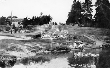 Eltham District Historical Society Inc
Negative - Photograph, Village Pond, near Main Road, Eltham, c.1908
Village Pond, near Main Road, Eltham, c.1908 Reproduced on p57 of 'Pioneers & Painters'. Looking up Dalton Street from across Maria Street (Main Road), near Whitecloud (Jarrold’s cottage) and the Bootmaker’s cottage, to the left (out of view) of the photographer. The residence of the Head Teacher, Eltham State School No. 209, can be seen on the right, the Grant house on the left (site of present day Eltham Clinic). The willow trees south of Jarrold’s Cottage today mark the site of the old pond, which the Eltham Shire Council evidently filled in to stop mosquitos breeding. The pond and its locality was described in an article about Eltham published in The Australasian, May 2, 1903 - “There is the village pond (so essentially English), reflecting in its clear water a quaint cottage, dwarfed by a huge gum tree, an old smithy, and a hostelry, built quite fifty years ago, the flooring-boards of which the landlord informed me with pride were of Singapore cedar, and quite fit for another fifty years' wear. Then there are the village school, the shoemaker's, the drapery store, and the butcher's shop, all seemingly as they were when first they were erected many years ago.”This photo forms part of a collection of photographs gathered by the Shire of Eltham for their centenary project book,"Pioneers and Painters: 100 years of the Shire of Eltham" by Alan Marshall (1971). The collection of over 500 images is held in partnership between Eltham District Historical Society and Yarra Plenty Regional Library (Eltham Library) and is now formally known as the 'The Shire of Eltham Pioneers Photograph Collection.' It is significant in being the first community sourced collection representing the places and people of the Shire's first one hundred years.Digital image 4 x 5 inch B&W Neg Print 16.5 x 25 cm (2) and 9 x 12.5 cm Postcard 9 x 14 cmOn one print "57 and 11 3/8' x 10' deep"shire of eltham pioneers photograph collection, dalton street, duck pond, eltham, grant house, main road, maria street, village pond -
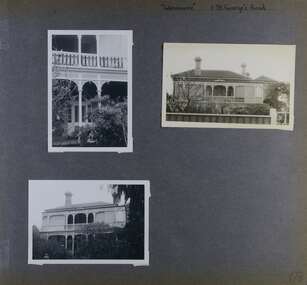 Glen Eira Historical Society
Album - Album page, Glenmoore, St George's Road, Circa 1972
This photograph is part of the Caulfield Historical Album 1972. This album was created in approximately 1972 as part of a project by the Caulfield Historical Society to assist in identifying buildings worthy of preservation. The album is related to a Survey the Caulfield Historical Society developed in collaboration with the National Trust of Australia (Victoria) and Caulfield City Council to identify historic buildings within the City of Caulfield that warranted the protection of a National Trust Classification. Principal photographer thought to be Trevor Hart, member of Caulfield Historical Society. Most photographs were taken between 1966-1972 with a small number of photographs being older and from unknown sources. All photographs are black and white except where stated, with 386 photographs over 198 pages. From Victorian Heritage Database citation for HO59 Glenmoore, 1 St Georges Road Elsternwick https://vhd.heritagecouncil.vic.gov.au/places/35202 as at 30/10/2020 "Glenmoore" is locally significant as a surviving mid nineteenth century villa residence in the then fashionable bi-chromatic brick form. It is also important as the home of Hugh Moore who built several shops in nearby Glen Huntly Road and which remain as important contributors to the architectural character of the Elsternwick Shopping Centre.Victorian Heritage Database citation HO59 Glenmoore, 1 St Georges Road Elsternwick https://vhd.heritagecouncil.vic.gov.au/places/35202 An imposing two storeyed villa in bichrome brick with two storeyed timber posted verandah, coupled with cast iron lace frieze, spandrels and central tympanum enrichment. The hipped roof is in slate and has a prominent crean1 brick chimney stack forming part of the facade. Openings are flat arched although the entrance is round arched with a fan light. The south elevation has bayed windows. Two storeyed hip roofed additions are sympathetic and attached on the north side and at the rear. Inside, the staircase and stained glasswork with initials "HM" and family coat of arms are important surviving elements. INTEGRITY: Good, timber outbuildings of an early date, mature and spacious front garden includes early palm trees. Alterations include reconstruction of facade verandah including tiled pavement and front door on east side. Interior has a high level of integrity. Original grounds included adjoining "Carramar".Page 178 of Photograph Album with three photographs of Glenmoore, St Georges Road. Handwritten: "Glenmoore" 1 St George's Road [top right] / 178 [bottom right]trevor hart, chimneys, porch, mansion, slate roof, return verandah, stained glass, cast iron frieze, glenmoore, 1860's, hugh moore, glenmoore estate, double storey, elsternwick shops, st george's road, thomas watts, elsternwick, victorian style, protruding bay windows, cast iron work, bi-chromatic bricks, gardens, balconies, moore's buildings, glen huntly road, stairs, house names -
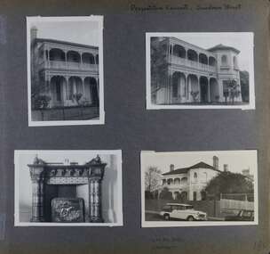 Glen Eira Historical Society
Album - Album page, Presentation Convent, Sandham Street, Circa 1972
This photograph is part of the Caulfield Historical Album 1972. This album was created in approximately 1972 as part of a project by the Caulfield Historical Society to assist in identifying buildings worthy of preservation. The album is related to a Survey the Caulfield Historical Society developed in collaboration with the National Trust of Australia (Victoria) and Caulfield City Council to identify historic buildings within the City of Caulfield that warranted the protection of a National Trust Classification. Principal photographer thought to be Trevor Hart, member of Caulfield Historical Society. Most photographs were taken between 1966-1972 with a small number of photographs being older and from unknown sources. All photographs are black and white except where stated, with 386 photographs over 198 pages. From Victorian Heritage Database citation for Presentation Convent, 28 Sandham Street https://vhd.heritagecouncil.vic.gov.au/places/35476 (as at 1/11/2020) - HO61 City of Glen Eira The "Presentation Convent" is locally significant as a substantial late Victorian villa residence in Elsternwick and for its more recent role in the educational and spiritual lives of the community. Other names: formerly "Cromarty School for Girls", "Chiselhurst". (National Trust entry on VHD mentions an association with Horatio Beauchamp without elaborating.) Currently this is St Joseph's Primary School.From Victorian Heritage Database citation for Presentation Convent, 28 Sandham Street https://vhd.heritagecouncil.vic.gov.au/places/35476 (as at 1/11/2020) - HO61 City of Glen Eira A substantial two storeyed stuccoed asymmetrical Italianate villa residence, representative of its period, with two storeyed cast iron verandah and projecting facetted bay with trabeated treatment to the ground floor and round arched upper level windows with distinctive moulds.Page 184 of Photograph Album with one portrait and three landscape photographs of Presentation Convent, Elsternwick. One is an internal fireplace and its mantelpiece.Handwritten: Presentation Convent, Sandham Street [top right] / CHISEL HURST / CROMARTY [under bottom right photo] / 184 [bottom right]trevor hart, chimneys, porch, school, education, presentation sisters, catholic girls college, balcony, verandah, presentation convent, sandham street, victorian villa residence, cast iron frieze, cast iron columns, protruding bay, bay window, 1880's, late victorian, cromarty, chiselhurst, chisel hurst, horatio beauchamp, elsternwick, victorian style, cast iron work, catholic church, mansions, house names, gardens, mantelpieces, fireplaces, streetscapes, cars, cromarty school for girls, st joseph's primary school, st josephs primary school -
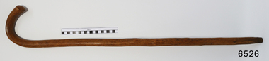 Flagstaff Hill Maritime Museum and Village
Accessory - Walking Stick, William Dale, early 1900's
In the words of the Donor, Betty Stone, "This walking stick was made by William Dale from wood obtained from his property Bluestone Quarries situated at Wangoom, Warrnambool. William Dale, the son of William Booth and Hannah (nee Broadbent) Dale was born on 8 July 1828 in Saddleworth, Yorkshire, England. He emigrated to Australia in 1852 and seven years later purchased twenty acres of land in the shire of Wangoom, Warrnambool where he operated a quarry known as The Dale Bluestone Quarries. According to family legend, when William and his wife Elizabeth (nee Chamberlain) first moved into their bluestone cottage on the property, it was surrounded by dense bush that abounded with wildlife. William Dale used this walking stick in his later years. Although physically bent after years of toil, his grandchildren remembered him wheeling his barrow and walking with his stick around the quarries when aged well over eighty years. William Dale died at his residence on 14 December 1913 aged 85 years." (Note: For additional information please refer to Betty Stone’s book “Pioneers and Places - A History of three Warrnambool Pioneering Families” ie. Chamberlain, Dale and Lees Families) This item is associated with the families of Chamberlain, Dale and Lees. These families are listed in the "Pioneers' Register" for Warrnambool Township and Shire, 1835-1900, published by A.I.G.S. Warrnambool Branch. The handmade walking stick was made from local resources.Walking Stick, polished wood with grain and knots showing. Brass tip, 'J' shaped handle. Made by William Dale in the early 1900's of wood from his property, "Dale Bluestone Quarries", Wangoom, Warrnambool. From the 'Chamberlain Dale and Lees Collection'.flagstaff hill, warrnaflagstaff hill, warrnambool, shipwrecked coast, flagstaff hill maritime museum, maritime museum, shipwreck coast, flagstaff hill maritime village, great ocean road, chamberlain, dale, lees, stone, betty stone, warrnambool pioneers, mbool, shipwrecked-coast, flagstaff-hill, flagstaff-hill-maritime-museum, maritime-museum, shipwreck-coast, flagstaff-hill-maritime-village, dale bluestone quarries, william dale, walking aid, walking stick, mobility aid -
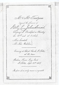 St Kilda Historical Society
Ephemera - Invitation - wedding, Invitation to wedding of Miss Swindles and Mr John Nicholson 1867, 1867 (original)
The Argus, 27 September 1867 p4 - MARRIAGES: NICHOLSON—SWINDELLS.—On the 12th inst., at Christ Church, St. Kilda, by the Rev. D. Seddon, John, eldest son of the late Hon. W. Nicholson, to Gertrude Sarah, youngest daughter of the late James Swindells, Esq., of Manchester. No cards. https://trove.nla.gov.au/newspaper/article/5779002 Barham House was built in 1850 by Edward Bernard Green (1809-1861) a successful land speculator. It was a magnificent residence built in the regency style to the design of architect John Gill and set in landscaped grounds of nine acres and included an ancient Swiss cottage. When Green died in 1861, his executor was his neighbour, William Nicholson (1816-65) who owned Fernleigh immediately to the north in Grey Street, but actually lived in Barham House during his time as Premier of Victoria 1859 - 1860 until his death in 1865. In 1866 Richard Twentyman purchased Fernleigh from the Nicholson Estate and a year later he married Nicholson's widow, Sarah. Both remained at Barham House until June 1870. In 1871 the building was substantially remodelled and re-named Eildon. It is one of the larger surviving 19th century houses in Melbourne.Black and white photocopy of invitation, wedding breakfast menu and envelope(handwritten) Original in possession of Lady Johnston. (handwritten) Gerty's marriage? Invitation: Mr and Mrs Twentyman request the pleasure of [unclear] Johnstone's Company at Breakfast on Thursday the 12th at 1 o'clock. Miss Swindells Mr John Nicholson. Ceremony at Christ Church St Kilda, at 12, Noon Barham House, Grey Street, St Kilda Sept. 2nd. 1867 The favour of an early answer is requested Menu: Déjeuner Barham House, St Kilda, 12. September, 1867. Menu items listed on following page Envelope: [unclear] Johnstone Esq Care of J C Johnstone Esq Sunburybarham house, christ church, st kilda, 19th century, eildon house, grey street -
 Melbourne Legacy
Letter, re. Captain Frank and Mrs Frank
Letter from Captain Bert Frank of 24 York St, St Kilda, applying for the manager position at the first Legacy Hostel, named Holmbush. It outlines his war service in WWI (with the 1st and 2nd A.I.F), civilian career running a Ford garage for 20 years and his interests. Also the education and experience of his wife, Clare Frank, and mentions their 10 year old son. It provides referees for both of them. Holmbush was the first hostel for children that Legacy started and operated from April 1943. It was later renamed Blamey House after another hostel called Blamey House was closed. Melbourne Legacy ran three residences: Blamey House (purchased 1947) , Stanhope (purchased 1945) and Harelands (purchased 1950), to take care of children whose fathers were servicemen, and who may have been left orphans, or whose mother may have been unable to care for them herself. Harelands accommodated boys and girls under the age of 14, Blamey House looked after boys over 14, and Stanhope looked after girls over 14. The children were cared for until they were old enough to become independent.Capt Frank was the successful applicant for the position and this letter provides a lot of background of his life.White note paper, lined, black ink handwriting, two hole punched.residences, holmbush, staff, bert frank -
 Melbourne Legacy
Letter - Document, letter, re. Appointment of Manager - Boy's Hostel
A 4 page job application from Thomas Mullins for the position of Hostel Manager. Lists his war service and loss of his left arm in France 1916. Also the family casualties suffered; mother in an air raid, father and brother through war service, brother living with the after effects of gas, plus his wife's father was a Kandahar veteran. It continues with his civilian experience and how his attributes would suit the position, then provides references. Holmbush was the first children's home established by Melbourne Legacy. It was later renamed Blamey House when the first Blamey House was sold. Melbourne Legacy ran three residences: Blamey House (purchased 1947) , Stanhope (purchased 1945) and Harelands (purchased 1950), to take care of children whose fathers were servicemen, and who may have been left orphans, or whose mother may have been unable to care for them herself. Harelands accommodated boys and girls under the age of 14, Blamey House looked after boys over 14, and Stanhope looked after girls over 14. The children were cared for until they were old enough to become independent.A record of written correspondence regarding job applications in 1943.Letter from Mr Mullins applying for a position at Holmbush handwritten on white foolscap paper and two hole punched.Handwritten "Withdrawn" in pencil at the top.residences, holmbush, holmbush administration -
 Melbourne Legacy
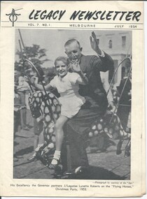
Magazine - Newsletter, Melbourne Legacy, Legacy Newsletter July 1954, 1954
The newsletter from July 1954. It featured Governor Sir Dallas Brooks on a carousel horse with a girl on the cover. The president's introduction talked ofvalue of books and reading. There was a piece on the death of Legacy founder Stan Savige and has a photo of funeral cortege. Pages showed news from the different Boys and Girls Classes and photos showcased the annual demonstration. Also photos of the Legacy library and the medical and dental care given to junior legatees. Also an article and photo about speech training by Miss Williams. Photo of mothers working hard at sewing costumes for the girls classes. There was an article about the royal visit of to the MCG and the JLs that presented flowers to the Queen. A newsletter published by Legacy in this format for many years from 1942. It mentions "Issued from time to time for Private Circulation among the Sons and Daughters of Deceased Service men and Merchant Seamen who served their Country during the War of 1914-18, or the present War". Many articles on the work of Legacy, including features on boys classes, girls classes, camps, the residences and where their past residents ended up. There are some suggestion for careers and some general interest articles. Some very interesting photos.Newsletter outlining news of Junior Legatee activities.Black and white printed newsletter x 16 pages from July 1954. Volume 7 Number 1boys classes, activities, girls classes, ilc