Showing 110195 items matching "roads"
-
 Whitehorse Historical Society Inc.
Document, The Milk Bar Report
School assignment on the history of a milk bar on the corner of Beddoe Road and Centre Road, Vermont written by Douglas Nash.School assignment on the history of a milk bar on the corner of Beddoe Road and Centre Road, Vermont written by Douglas Nash.School assignment on the history of a milk bar on the corner of Beddoe Road and Centre Road, Vermont written by Douglas Nash.milk bars, beddoe road, vermont, centre road -
Whitehorse Historical Society Inc.
Article, The Drill to protect valley, 2005
First of four road-headers started drilling at Mitcham Road end of Mullum Mullum Valley tunnel, with photo.First of four road-headers started drilling at Mitcham Road end of Mullum Mullum Valley tunnel, with photo.First of four road-headers started drilling at Mitcham Road end of Mullum Mullum Valley tunnel, with photo.mitcham road, mitcham, eastlink, mullum mullum valley, aubrey, chris, batchelor, peter -
Whitehorse Historical Society Inc.
Legal record - Land Title, Springvale Road, 1960
Aerial photograph of cnr. Springvale Road and Burwood Highway, south past Highbury Road and east to Vermont South.Aerial photograph of cnr. Springvale Road and Burwood Highway, south past Highbury Road and east to Vermont South.Aerial photograph of cnr. Springvale Road and Burwood Highway, south past Highbury Road and east to Vermont South.aerial photographs, springvale road, burwood east, burwood highway, burwood east, highbury road, burwood east, vermont south -
Whitehorse Historical Society Inc.
Correspondence, Healesville Road, 24/03/1937
Claim for reimbursement from the Country Roads Board of amounts expended on Main Healesville Road by Shire of Blackburn and Mitchamhealesville road, victoria. country roads board, shire of blackburn and mitcham, roads and streets -
Whitehorse Historical Society Inc.
Document - Correspondence, Healesville Road, 9/04/1937
Claim for reimbursement from the Country Roads Board of amounts expended on the Main Healesville Road by Shire of Blackburn and Mitchamhealesville road, shire of blackburn and mitcham, victoria. country roads board, roads and streets -
Whitehorse Historical Society Inc.
Document - Correspondence, Healesville Road, 26/04/1937
Claim for reimbursement from Country Roads Board for amounts expended on Main Healesville Road by Shire of Blackburn and Mitchamshire of blackburn and mitcham, victoria. country roads board, roads and streets, healesville road -
Whitehorse Historical Society Inc.
Document - Correspondence, Healesville Road, 18/06/1937
Claim for reimbursement from Country Roads Board of amounts expended on Main Healesville Road by Shire of Blackburn and Mitchamshire of blackburn and mitcham, victoria. country roads board, roads and streets, healesville road -
Whitehorse Historical Society Inc.
Newspaper - Article, 134 Central Road, Blackburn, 10/03/1988
Advertisement for auction of 134 Central Road, Blackburn by Noel Allen, with newspaper article re 134 Central Road.central road, blackburn, boyd, robin, auctions -
 Whitehorse Historical Society Inc.
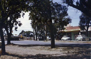
Photograph, Vermont Shops C.1967, C.1967
Part of Tim Shambrook's Collection for 'This is Vermont'. Not used.Coloured photo of Vermont Shops on corner of Canterbury and Boronia Roads, Vermont, in 1967. Looking south to Boronia Road.canterbury road, vermont, boronia road, shambrook, tim -
 Whitehorse Historical Society Inc.
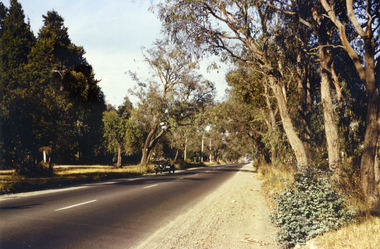
Photograph, Canterbury Road, Vermont, 1967
Part of Tim Shambrook's Collection for 'This is Vermont'. Not used.Coloured photo of Canterbury Road, Vermont, taken in 1967 showing one lane road and heavily treed verge.canterbury road, vermont, shambrook, tim -
 Whitehorse Historical Society Inc.
Photograph, Brunswick Road, Mitcham, 8/09/1958 12:00:00 AM
Black and white photo of Brunswick Road, Mitcham. (Was previously Northcote Road.) Comments as for Forster Street Mitcham. - NP1075.o'rourke, l. -
 Whitehorse Historical Society Inc.
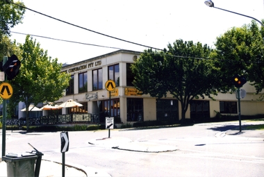
Photograph, Enrik's Restaurant, Blackburn, 2012
Coloured photograph of Enrik's Restaurant, corner of Surrey Road and Railway road, Blackburn. 3 Umbrellas in front - 2012enrik's restaurant, blackburn, restaurants, station street, railway road -
Canterbury History Group
Photograph - Street view of the Canterbury Post Office, Stuart Warmington, 1995
Coloured photograph of street view of the Canterbury Post Office on the corner of maling and Canterbury Roads at 206 Canterbury Roadcanterbury, maling road, shops, edwardian architectural design -
Canterbury History Group
Photograph - Street view from Maling Road of the Canterbury Post Office at No. 206 Canterbury Road, Canterbury, Stuart Warmington, 1995
Coloured photograph of street view from Maling Road of the Canterbury Post Office at No. 206 Canterbury Road, Canterburycanterbury, maling road, shops, edwardian architectural design -
Canterbury History Group
Photograph - Street view from Canterbury Road of the Canterbury Post Office at No. 206 Canterbury Road, Canterbury, Stuart Warmington, 1995
Coloured photograph of street view from Canterbury Road of the Canterbury Post Office at No. 206 Canterbury Road, Canterburycanterbury, maling road, shops, edwardian architectural design -
Canterbury History Group
Photograph - Street view from Maling Road of the Canterbury Post Office at No. 206 Canterbury Road, Canterbury, Stuart Warmington, 1995
Coloured photograph of street view from Maling Road of the Canterbury Post Office at No. 206 Canterbury Road, Canterburycanterbury, maling road, shops, edwar, edwardian architectural design -
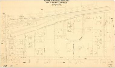 Camberwell Historical Society
Map (Item) - MMBW map, Melbourne and Metropolitan Board of Works, Melbourne and Metropolitan Board of Works - Shire of Boroondara and Camberwell - Detail Plan no. 1860, August 1904
Lithographer E.H.H., Exd J.W.D, June 1904, No. 70. 40P.15W.melbourne and metropolitan board of works, map, camberwell, cartography -
Canterbury History Group
Photograph - Streetscape along Maling road outside No. 88 Maling Road, Jan Pigot, 27/03/1993 12:00:00 AM
Coloured photograph of the streetscape outside No.88 Maling Road showing people sitting outside the Maling Road Patisserie.canterbury, maling road, shops, streetscapes, wunderlite ceilings -
Canterbury History Group
Photograph - Street view of the position of the bronze footpath plaque at the Canterbury Road and Maling Road junction, Jan Pigot, 2004
Coloured photograph of thes treet view of the position of the bronze footpath plaque at the Canterbury Road and Maling Road junction.canterbury, maling road, shops, signs, plaques -
Canterbury History Group
Photograph - Group of Maling Road traders posing for a photograph in period costume in Maling Road with the photogrpaher in view, Jan Pigot, 27/03/1993 12:00:00 AM
Coloured photograph of a group of Maling Road traders posing for a photograph in period costume in Maling Road with the photogrpaher in viewcanterbury, maling road, shops, fashion -
Canterbury History Group
Photograph - Group of Maling Road traders posing for a photograph in period costume with the photographer in view in Maling Road, Jan Pigot, 27/03/1993 12:00:00 AM
Coloured photograph of a group of Maling Road traders posing for a photograph in period costume with the photographer in view in Maling Roadcanterbury, maling road, shops, fashion -
Canterbury History Group
Photograph - Photograph of the enamel picture plaque for Maling Road in the 1920s, Jan Pigot, 2004
Coloured photograph of the enamel picture plaque for Maling Road in the 1920s on the brick wall of 80 Maling Road, Canterburycanterbury, maling road, shops, signs, plaques -
Whitehorse Historical Society Inc.
Article, People before profit - land sale opponent, 1992
A community group has criticised Nunawading Council's move to rezone and sell the Vermont South site it uses.A community group has criticised Nunawading Council's move to rezone and sell the Vermont South site it uses. The land is on the corner of Burwood Highway and Livingstone Road which is zoned D 'Public Open Space'. Council has deferred the decision to rezone until after a public meeting.A community group has criticised Nunawading Council's move to rezone and sell the Vermont South site it uses.town planning, city of nunawading, burwood highway, vermont south, livingstone road, vermont south, vermont south -
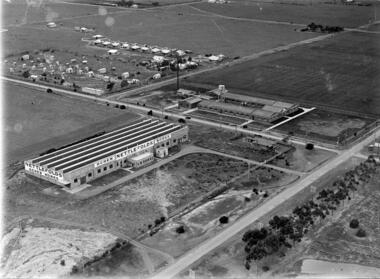 Sunshine and District Historical Society Incorporated
Photograph - Three Old Sunshine Factories, Pratt, Charles Daniel, (1892 - 1968), Photographed circa late 1920's to early 1930's
These three factories clustered together and close to Albion Station provided manufacturing type of employment for several decades. All the factories have now disappeared and have been replaced by retail or service businesses. Spalding has been replaced by a Bunnings Hardware store, while the main retail outlet on the Nettlefolds site is Harvey Norman. Ironically part of the Phoenix Fireworks site is now occupied by the Metropolitan Fire Brigade, as well as other small businesses including a smash repair business, and a tyre retailer.The photograph provides a historical record of some of the types of manufacturing industries that existed in Sunshine, before retail or service industries began to replace them. Many of the younger generation do not know that fireworks, screws, or some sports items were manufactured in Sunshine not so long ago, and where the factories existed.The image depicted in this photographic copy is believed to be from circa late 1920's to early 1930's, and shows the NETTLEFOLDS, SPALDING, and the PHOENIX FIREWORKS factories. These factories were located in North Sunshine on the north side of Ballarat Road near Albion Station. Nettlefolds and Spalding are on the corner of Ballarat Road and McIntyre Road, with Nettlefolds being on the west side of McIntyre Road and Spalding on the east. Phoenix Fireworks factory is composed of small huts, and is situated on the north side of Phoenix Street at the rear of the Spalding factory. The photograph also shows a row of residential houses on Garnet Street which is on the east side of the Phoenix factory. Ballarat Road is still an undivided road and on the south side is a plantation of trees that once stretched from near Albion Station to Anderson Road. Other roads visible are Suffolk Road and Westmoreland Road.Nettlefolds Screw Worksnettlefolds, spalding, phoenix fireworks, screw works, ballarat road, mcintyre road, phoenix street, garnet street, westmoreland road, suffolk road. -
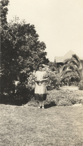 Kew Historical Society Inc
Photograph - In the 'Alexandra Gardens', Kew, 1927
The Alexandra Gardens in Cotham Road, Kew were opened by the Governor of Victoria in 1910. The first curator of the gardens was George Pockett, who with his brother is credited with the layout of the gardens. The gardens were constructed on land originally owned by the King family of 'Madford' in Wellington Street. The land on which the gardens were developed was originally the back paddock of 'Madford' which was purchased by the Borough of Kew in 1906.A rare and early photograph of the gardens showing clearly the changes to the layout and planting during the 1920s. Small, sepia coloured photographic positive of a woman standing on the grass in front of a garden bed in the Alexandra Gardens in Cotham Road, Kew. The Centennial Rotunda, built in 1910, can be seen in the background. Annotation verso: "Alexandra Gardens Kew 1927"parks and gardens -- kew (vic.), alexandra gardens -- kew (vic.), george pockett -
Ringwood and District Historical Society
Newspaper - Newspaper cutting, The story of the Ringwood Memorial Clock Tower erected 1928 incl list of Roll of Honour names, 4-Aug-28
Around 1940-42 the clockwork mechanism was wound by hand for payment of 2/6 (25 cents) per week, payable half yearly. The clock tower was removed and re-erected in 2000 at the intersection of Maroondah Highway and Wantirna Road, with a new electric winding mechanism.The story of the Ringwood Memorial Clock Tower erected 1928 at a cost of approx $1700 and unveiled 4-Aug-1928 at the intersection of Maroondah Highway and Warrandyte Road. It commemorates those who served and those who lost their lives in WW1.ROLL OF HONOUR; Addison, W.J.; Allan, A.; Bailey, A.F.; Bolton, E.; Brain, W.; Brown, A.G.; Brown, W.; Brown, C.H.; Browning, D.; Brocksop, P.; Bruce, R.T.; Butler, W.J.; Cairnduff, J.B.; Castles, D.; Chivers, S.R.; Chivers, A.; Clemson, J.K.; Cutts, C.W.G.; Cutts, N.F.L.; Cooper, J.; Dehne, P.C.; Dawes, L.F.; Dawes, F.A.; Dawes, C.A.R.; Foster, A.; Franks, C.V.W.; Ford, T.; Franklin, E.; Fitts, E.; Goodall, R.; Goodall, J.H.; Grant, T.W.; Guy, W.H.; Hannah, J.; Harris, D.B.; Hardidge, B.; Hains, C.L.; Hefferson, R.H.; Hodgetts, L.F.; Hodgetts, W.C.; Homewood, L.; Howship, M.L.; Howship, F.R.; Howship, S.P.; Hubbard, H.; Johnston, W.J.; Johnston, R.A.; Johnston, C.H.; Justice, Rev. T.H.; Kennedy, G.; Kraefft, H.G.; Lang, A.C.; Larkwing, A.H.; Lawlor, J.; Lothian, J.C.; Maggs, C.B.; Martin, E.; McCann, R.; McGillvray, M.; McKinnon, J.; Miles, Sister A.F.; Miles, T.A.; Miles, R.F.; Miles, K.L.; Miles, L.E.; Milner, T.; Miller, S.; Moss, L.S.; Moss, C.B.; Muller, G.W.; Muller, J.H.; Neal, A.G.; Nield, F.N.; Parker, A.; Parker, R.; Parker, F.V.; Parker, T.S.; Paris, C.C.; Peake, A.; Pearson, H.F.; Pollard, J.L.; Ratten, C.J.; Ratten, W.G.; Read, I.; Sanders, J.; Shanks, R.J.; Smith, S.; Smith, P.C.; Smith, C.; Stephenson, R.H.; Stowell, H.A.; Taylor, J.; Thomas, H.O.; Thomas, I.; Thompson, A.R.; Thorpe, J.G.; Tomholt, S.J.; Toogood, E.G.; Venables, W.E.; Walker, J.; Wedge, C.H.; Wedge, J.W.K.; Whitchurch, A.; Wilson, L.J.; Williams, J.A.; Williams, W.G.; Wright, S.; Wright, J.W.C.; DIED ON SERVICE; Johnston, C.H.; McCann, H.J.; Mackinlay, H.W.; Mitchell, L.; Morris, J.; Pollard, H.L.; Palmer, E.R.; Parker, J.J.; Rooney, E.; Schonfelder, A.W.; Thurrowgood, W.; Todd, J.; Thomas, R. -
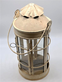 Glenelg Shire Council Cultural Collection
Domestic object - Lantern, Thomas Ward, 1884
This lantern was made by Thomas Ward in 1884 for his daughter Alice Fawthrop Ward to see her way to the little church Wellington Road, where she played the organ for the mid week service. An early example of lighting used in the late 1800s. Additionally this particular light was made by Thomas Ward who was a part of a prominent family in Portland at the time. Thomas was part of the crew that went out to the Admella Shipwreck. The above mentioned church was built in 1870, and is now part of a private residence. Metal lantern painted cream. Round base with 6 rectangle shaped glass panels with 2 curved reinforced metal braces rounding the circumference of the body. One of the panels is a functioning door to allow candle access, door is secured by a thin pin with a ring pull to slide pin up and down. Top is domed with a decorative waves cap. Thin metal carry handle attached by two side braces. Cylinder holder in the base for a candle, and contains a small new looking candle.Hand written label: This lantern was made by Thomas Ward in 1884 for his daughter Alice Fawthrop Ward to see her way to the little church Wellington Road, where she played the organ for the mid week service.thomas ward, city of portland, lantern, alice ward, church, admella shipwreck, portland lifeboat -
Surrey Hills Historical Society Collection
Planning report, City of Boroondara, City of Boroondara planning report re 171 Union Road, Surrey Hills, 19/07/2004
171 Union Road was part of the Thomas Zeplin estate. It originally had a Victorian house on it built by the Zeplin family. This was leased by Dr Percy Liddle and then Dr James Landells Blakie. Dr Blakie purchased land diagonally opposite at 174 Union Road and had a purpose-built home / surgery constructed. Later the site was occupied by COR then a BP petrol station.A detailed proposal regarding the redevelopment of the petrol station site on the corner of Union Road and Montrose Street, Surrey Hills into a 2 storey office and shop building with basement parking and access from Montrose Street. It includes attachments showing plans, elevations and details regarding objectors. The application was granted subject to additional conditions being met. union road, redevelopment, shops, town planning -
 Bendigo Historical Society Inc.
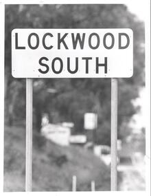
Photograph - BENDIGO ADVERTISER COLLECTION: ROAD SIGN OF LOCKWOOD SOUTH, 10/08/1993
Road sign of Lockwood South.Bill Hawkinsregion, small towns, lockwood south -
 Robin Boyd Foundation
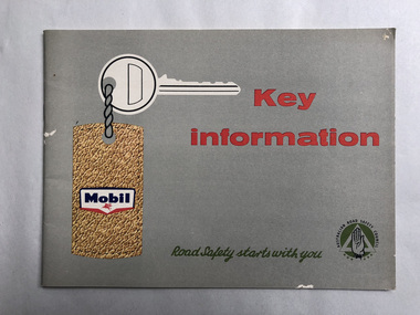
Booklet, Mobil Oil Australia, Key information
Illustrated road safety manualautomobiles, manuals, road safety, walsh st library