Showing 53840 items
matching documents-maps
-
 Koorie Heritage Trust
Book, Beauglehole, A. C, The distribution and conservation of vascular plants in the Murray Valley area, Victoria, 1986
ii, 81 p. : ill., maps ; 21 x 30 cm. + col. map.botany -- murray river valley (n.s.w.-s.a.) -
 Wodonga & District Historical Society Inc
Map - Boorgunyah - "The Town that never was"
At the height of the river trade, there was a town surveyed and laid out, and streets were named. This town was to house the workers at the river port of Red Bank when the paddle steamers plied the Murray River as far as Albury, carrying produce such as wool and wheat to the various towns along the river in the 1800s. As the river trade died away, this town never went ahead – one might say, “The town that never was.” A lone gum tree stands on the site today.This item is significant because it documents plans which were made for the early development of Wodonga.A black an white map depicting the proposed location of the township. The map is based on a sketch and is not to scale,early wodonga, boorgunyah - "the town that never was", wodonga heritage -
Melbourne Tram Museum
Document - Specification - set of 7 - worker ammenties etc, Melbourne & Metropolitan Tramways Board (MMTB), mid 1950s
Seven documents for the supply and delivery of equipment and sheds for track workers - All undated. 1 - "Five oil-fired 25 gallon urns for boiling water" - 4 sheets 2 - "Two (2) mobile bitumen heaters - oil fired" - 6 sheets 3 - "Six (6) mobile tool boxes" - 4 sheets 4 - "Three hundred (300) barricade posts and six hundred (600) barricade rails - 4 sheets 5 - "Five (5) portable gangers' offices" - 5 sheets 6 - "Two (2) portable lamp cabins" - 7 sheets 7 - "Four (4) mobile conveniences" - 4 sheetsYields information about the MMTB tender for track workers facilities and equipment.Set of seven documents - foolscap sheets stapled in top left hand corner and hole punched along the top edge.mmtb, tramways, contracts, purchases, trackwork, tools -
 Bendigo Historical Society Inc.
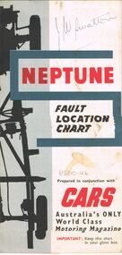
Map - J W SWATTON COLLECTION: MAPS
Seven maps of various sizes. Map of the City of Ballarat, Victoria, Road Condition Map of Victoria including Melbourne-Cairns & Melbourne-Adelaide, Neptune Fault Location Chart, Grampians District Map, Racv Tour Planning Map Showing Road Conditions for Victoria, NSW and Queensland and Mt Macedon & District. Two of the maps have J W swatton & J Swatton written on them.j w swatton collection, racv, mobil, neptune, a r blair, j ewins & sons pty ltd, berry anderson & co -
Whitehorse Historical Society Inc.
Document, Roy Rogalski, 1/11/2006 12:00:00 AM
Interview with Roy Rogalski, who migrated to Australia from Poland in 1950.Interview with Roy Rogalski, who migrated to Australia from Poland in 1950. Interviewed by Bob Gardiner 2 November 2006 and 15 February 2007. With copies of photos and documents supporting a claim for compensation from the German government.Tape at NP3466.Interview with Roy Rogalski, who migrated to Australia from Poland in 1950. rogalski, roy, oral history migration program, emigration, poles in australia -
 Bendigo Military Museum
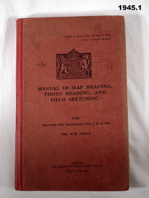
Manual - TRAINING MANUALS, 2), .3), & .4) Her Majesty's Stationery Office, Manual of Map Reading, Photo Reading, and Field Sketching, 1) 1929, Reprint 1939; .2) 1955; .3) 1957; .4) 1958
Training Manuals - War Office London 1920 - 1939. .1) Red coloured cardboard with red coloured buckram, spine, black print on front & Coat of Arms. 166 pages, cut, plain, off white paper with black & white & coloured maps & diagrams. .2), .3) & .4) Red coloured cardboard with red coloured buckram, spine, black print on front. Cut, plain, off white paper with black & white & coloured maps & diagrams. .2) 132 pages. .3) 80 pages. .4) 69 pages. .1) “1929 Reprinted with amendments No's 1 to 4 1939” .2) “1955 Part 1 Map Reading” .3) “1957 Part III Field Sketching” Front fly leaf in red ballpoint pen: “S Sgt Moore / LAD” .4) “1958 Part II Air Photo Reading”books-military history, technical, documents - maps -
Whitehorse Historical Society Inc.
Document, Villa Residence, 11/12/1937 12:00:00 AM
Auction brochure for 'beautiful modern brick villa residence', with 4 1/4 acres of land, Mitcham Road Mitcham, Saturday December 11 1937.Auction brochure for 'beautiful modern brick villa residence', with 4 1/4 acres of land, Mitcham Road Mitcham, Saturday December 11 1937, under instructions from the executors of the estate of the late E. E. Walker. Frontages to Mitcham Road, Delhi Street and Agra Street. Auctioneers: Baillieu Allard in conjunction with Drake & Co. Original copy framed, located in Map Drawer.Auction brochure for 'beautiful modern brick villa residence', with 4 1/4 acres of land, Mitcham Road Mitcham, Saturday December 11 1937.walker, edgar edwardes, walker estate, mitcham road, mitcham, delhi street mitcham, agra street, mitcham, drake & co., baillieu allard pty ltd -
Bendigo Historical Society Inc.
Document - Digital, KEN BICE COLLECTION: MINER'S RIGHT FRANK BICE
Copy of document, Miner's Right issued to Frank Bice on 4/10/46. This is a digital only document.cottage, miners, bendigo, bice, miner's right, mining -
 Bendigo Historical Society Inc.
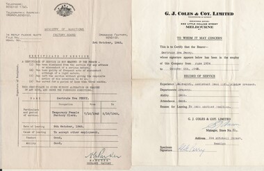
Document - GERTRUDE PERRY COLLECTION: DOCUMENTS RELATING TO GERTRUDE PERRY'S EMPLOYMENT, 1934 - 1980
Documents. Documents & references relating to Gertrude Perry's employment history including G. J. Coles & Co.organization, gertrude perry collection, documents relating to gertrude perry's employment, g. j. coles & co. -
 Bendigo Historical Society Inc.
Document - MCCOLL, RANKIN AND STANISTREET COLLECTION: NORTH VIRGINIA GMC N L - ISSUE OF 50,000 CONTRIBUTING SHARES, 2/5/1947
Document. Cardboard folder (tan) containing documents concerning shares. North Virginia GMC N L.McColl, Rankin & Stanistreetorganization, business, north virginia gmc n l, mccoll, rankin & stainstreet, north virginia gmc n l, gold mining, shares -
 Bendigo Historical Society Inc.
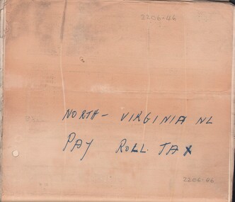
Document - MCCOLL, RANKIN AND STANISTREET COLLECTION: NORTH VIRGINIA GMC N L - PAY ROLL TAX RETURNS, July 1941 - 16 Sept 1948
Document. 60 documents pertaining to returns of wages of payroll tax. The Commissioner of Taxation for North Virginia GMC.McColl, Rankin & Stanistreetorganization, business, north virginia gmc n l, mccoll, rankin & stanistreet, north virginia gmc n l, gold mining, pay roll tax returns -
 National Vietnam Veterans Museum (NVVM)
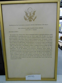
Document, AATTV Meritorious Unit Commendation Details
Framed document in a gold frame. Document outlines details of the Citation Awarded to AATTV Capt I.C. TeagueSecretary of the Army logoframed document, aattv, capt i.c.teague, meritous unit commendation -
 National Vietnam Veterans Museum (NVVM)
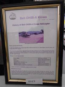
Document, Bell OH58-A Kiowa
Black Framed Document. Document outline History and Specifications of Bell OH58-A Helicopter with 161 RECCE SQN.framed document, oh58a, kiowa, 161 reconnaissance squadron, nui dat -
 National Vietnam Veterans Museum (NVVM)
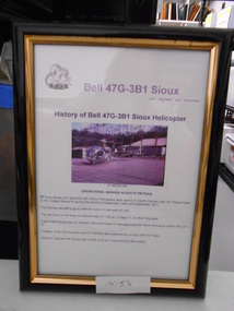
Document, Bell 47G - 3B1 Sioux
Black Framed Document. Documented History of Bell 47G - 3B1 Sioux in Vietnam with 161 Recce Flightframed document, 161 reconnaissance flight, bell 47 sioux -
Bendigo Historical Society Inc.
Map - BENDIGO, issued 1st January 1906
Map: Sketch map of Bendigo, including Eaglehawk and the Parish of Sandhurst. Issued by the Fire Underwriters Association of Victoria. Revised copy (number 317 in map cupboard 1)map, bendigo, city streets, map of bendigo, fire underwriters association of victoria -
 Bendigo Military Museum
Photograph - Lithographic Technicians preparing a Cromalin map proof at the Army Survey Regiment, Fortuna Villa Bendigo
These six photographs were most likely taken in the 1990s in Lithographic Squadron at the Army Survey Regiment, Fortuna, Bendigo. There is no annotation describing the date or personnel in the photographs. Cromalin proofing was a laminate and dry powder proofing system introduced in 1978. The system allowed the production of true to colour proofs, mainly for the proofing of orthophoto maps and process printed 1:250,000 JOG that used positive printing plates. It was upgraded in 1986. The pre-press proof was a cost-effective way of producing a one-off visual copy of the map or chart product. It enabled cartographers to perform a quality inspection and correct any faults before publication. The pre-press proof was deemed authoritative before its release to Print Troop for bulk printing and distribution.This is a set of six photographs of lithographic technicians preparing Cromalin map proofs at the Army Survey Regiment, Bendigo c1990s. The photographs were on 35mm negative film and were scanned at 96 dpi. They are part of the Army Survey Regiment’s Collection. .1) to .6) - Photo, colour, c1990s, printer technician SPR Shona Hastie, Lithographic Squadron. .1P to .6P – no annotationroyal australian survey corps, rasvy, army survey regiment, army svy regt, fortuna, asr, litho -
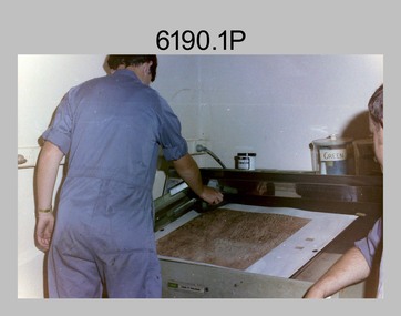
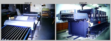 Bendigo Military Museum
Photograph - Print Troop Equipment, Lithographic Squadron – Army Survey Regiment, Fortuna, Bendigo, c1990s
This is a set of 25 photograph of Print Troop Equipment in Lithographic Squadron, Army Survey Regiment at Fortuna, Bendigo, 1990. Photo .1P features the new Howson Algraphy Autoneg printing plate processor. It improved quality control and efficiency and allowed the conversion of printing plates for positive or negative use. The Heidelberg Speedmaster 102 shown in photos .2P to .4P was a computer-controlled five colour lithographic offset printing press. It provided the Royal Australian Survey Corps a vastly improved printing capability, as the five colours for a standard topographic map was printed in a single pass. The print room housing the Speedmaster printing press was named Wayzgoose Hall after a medieval printing house festival. Wayzgoose Hall and the Speedmaster printing capability was commissioned by the Commander of the 3rd Military District BRIG P. Davies AM, ADC on Wednesday 27th June 1990. This occasion is covered in more detail in page 145 of Valerie Lovejoy’s book 'Mapmakers of Fortuna – A history of the Army Survey Regiment’ ISBN: 0-646-42120-4. For additional photos, refer to item 6062.4P for more photos of the Heidelberg Speedmaster printing press. The Print Room’s Map Assessment and Colour Evaluation Stations in photos .5P to .12P provided the Printer Technician suitable viewing environments to perform quality assessments of map samples. See item 6151.34P for more information and photos of technicians using the equipment. The Print Room’s Map Handling Station in photo .15P to .20P provided ergonomic benefits to the Printer Technician and improved despatching productivity. See Item 6070.9P for more information and photos. The Wohlenberg MCS-2 guillotine seen in photos .21P & .22P was a heavy-duty guillotine integrated component of the Map Handling Station, to trim bulk printed map stock. See item 6069.6P for more information and photos of earlier types of guillotine equipment. This is a set of 25 photograph of Print Troop Equipment in Lithographic Squadron, Army Survey Regiment at Fortuna, Bendigo, 1990. The photographs are on 35mm colour slides and were scanned at 96 dpi. They are part of the Army Survey Regiment’s Collection. .1) - Photo, colour, c1990s, Howson Algraphy Autoneg printing plate processor .2) to .4) - Photo, colour, 1990. Heidelberg Speedmaster 102 computer-controlled five colour lithographic offset printing press .3) to .10) - Photo, colour, c1990s, Heidelberg Speedmaster CPC 1-04 control unit. .11) to .12) - Photo, colour, c1990s, Map Colour Evaluation Work Station. .13) to .14) - Photo, colour, c1990s, Linear printing plate registration punch. .15) to .20) - Photo, colour, c1990s, Print Room’s Map Handling Station. .21) to .22) - Photo, colour, c1990s, Wohlenberg MCS-2 guillotine. .23) - Photo, colour, c1990s, Print Room Power supply equipment. .24) to .25P - Photo, colour, c1990s, Print Room Crown Fork Lift..1P to .25P - There are no annotations stored with the 35mm slides.royal australian survey corps, rasvy, army survey regiment, army svy regt, fortuna, asr, printing, litho -
 Ballarat Tramway Museum
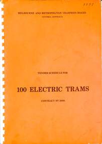
Document, Melbourne and Metropolitan Tramways Board (MMTB), "Tender Schedule for 100 Electric Trams Contract No. 3000", 1977
Compiled and published by the Melbourne and Metropolitan Tramways Board, closing Monday 10 May 1977. Details the conditions of tender, conditions of contract, notes, specifications, gives background information about Melbourne, dimensions, performance, drivers and conductors, trucks, wheels, brakes, electrical equipment, control panels and drawings. The drawings give a map of the system, typical city route, Glenferrie Road route (grade diagram), concrete track construction, min. radius curves, loading gauge, all-electric tram and mounting details for the trolley base, schedule of prices, tender form, form of contract, and schedule of information to be provided by the tenderer. Includes an Alphabetical Index. Includes a drawing for a single-ended version of the tramcar. Became the Z3 class following the addition of a rear or 3rd door. Yields information about the 1977 tender for 100 electric tramcars that became the Melbourne Z3 class tram.Comb bound (white plastic) specification or tender document, approx 180 pages, with glossy card orange covers, titled "Tender Schedule for Electric Trams" and "Contract 3000". "1977" on front cover in ink.tramways, tramcars, z3 class, specification, tenders, mmtb, melbourne, single ended tramcars -
 Ringwood and District Historical Society
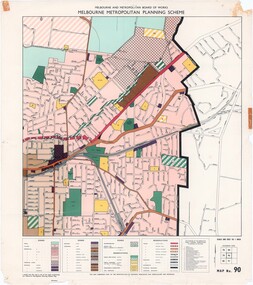
Map - Melbourne Metropolitan Planning Scheme, Municipality of Ringwood area - circa 1970
Colour-coded map marking proposed and existing business, industrial, transportation, public reservation, etc. planning zones within the City of Ringwood. Includes (undated) certification that this map is one of the maps constituting the Melbourne Metropolitan Planning Scheme Map.Scale: 800 feet to 1 inch. -
Bendigo Historical Society Inc.
Document - MARKS COLLECTION: MAP OF EAGLEHAWK/LONG GULLY AREA
Map of Eaglehawk and Long Gully area. Maps shows allotments and areas. Map is split down centre (torn ?) and in two pieces. Map was located in Fortuna papers, potentially belonged to G. Lansell. Section of map has been neatly cut out - area near Mt Korong Road and Victoria Hill. -
 Kew Historical Society Inc
Map, Robert Russell, Map Shewing the Site of Melbourne and the Position of the Huts & Buildings Previous to the Foundation of the Township by Sir Richard Bourke in 1837
Map shows the first layout of Melbourne by Government surveyor Robert Russell, who accompanied Governor Richard Bourke in 1837. The surveyed blocks extend from present-day Flinders Street to Lonsdale Street, and Spring Street to Spencer Street, with extensive vacant land west to a salt lake (afterwards Batman's Swamp, later drained), north beyond Flagstaff Hill and south towards South Melbourne. Vegetation coverage is indicated, and tracks and existing buildings and cultivated land are shown.Printed map was created by Day & Haghe, Lithographers to the Queen, sometime after 1838, when the company received its Royal appointment. Copies of the 1837 map exist in several major map collections in Australia; most are uncoloured. This particular map is the earliest in the Kew Historical Society's map collection. It is a nationally significant artefact. Black and white lithographed map hand-coloured in blue and yellow gouache of the town of Melbourne in 1837. In contrast to the original lithograph, the river and the township blocks are coloured blue and yellow. A similar, partly coloured copy is in the collection of the University of Melbourne.maps - melbourne - 1830s, governor sir richard bourke, robert russell - surveyor, cartography -
 Bendigo Historical Society Inc.
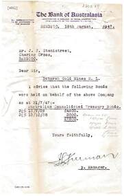
Document - MCCOLL, RANKIN AND STANISTREET COLLECTION: DEBORAH GOLD MINES NL BONDS SOLD, 1947
Documents: sheaf of documents pinned in top right hand corner from The Bank of Australasia and Hiskens and Leonard regarding bonds sold. Letter from bank is first document, with accompanying receipts.organization, mining, deborah gold mines nl, mccoll, rankin and stanistreet: deborah gold mines nl, bonds, leonard and hiskens -
 Bendigo Historical Society Inc.
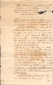
Document - MARKS COLLECTION: REPORT ACCOMPANYING PLAN ON THE BALLERSTEDT & SONS MINE, VICTORIA HILL
Handwritten two page document. On top of document: Report accompanying plan on the underground working in Messrs Ballerstedt & sons ( indecipherable word ) mine, Victoria Hill. This document refers to item 8300.bendigo, mining, ballerstedt & son mine -
 Warrnambool and District Historical Society Inc.
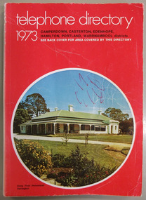
Book, Telephone Directory 1973, 1973
The numbers listed in this directory are under the heading of districts and the listings within the districts are again sub-listed under the various towns. So in the Warrnambool district there are listings under Winslow, Panmure, Orford, Port Fairy. Wangoom etc.This directory is of some importance as the names and addresses of those with telephones in 1973 in the local areas are listed. Most of the listings of the smaller towns give the names of the homes and properties. So this is a very useful tool for research purposes.This is a soft cover booklet with a red cover and an oval-shaped insert colour photograph of Stony Point Homestead, Darlington, on the front cover and a map of the telephone area on the back cover. Front cover – Telephone Directory 1973, Camperdown, Casterton, Edenhope, Hamilton, Portland, Warrnambool districts. See back cover for area covered by this directory Spine – Camperdown, Casterton, Edenhope, Hamilton, Portland, Warrnambool districts. See the pink pages for business & trade listings. VI- 1973 Back Cover – Country directory areas. The area covered by this Directory is the coloured portion of this map. See the pink pages for business and trade listings. warrnambool, warrnambool telephone directory 1973 -
 Ringwood and District Historical Society
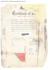
Document, Certificate of Title - Edward Thomas Miles, Gentleman, "Woorara", Ringwood - part of Crown Section 20, Parish of Warrandyte, County of Evelyn - 1913
A4 copies of damaged Landata Victoria Historical Search documents - Vol 3726 Fol 200 - incomplete proprietor and transfer details.Edward Thomas Miles is now the proprietor of an Estate in Fee-simple subject to the Encumbrances notified hereunder ... 27 acres 19 perches or thereabouts, together with a right of carriage way over roads coloured brown. Subdivision map includes un-named roads - western side is Wonga Road (later Warranwood Road), and eastern side is Grandview Grove (later Bemboka Road), both north of Plymouth Road, Ringwood, Vic. Transfers include (illegible) Dobbs, November, 1927 - 5 acres Harry Temple Marshall, 1st December, 1928 - 10ac 3r David Edward Meyland, 4th October, 194-? (illegible). -
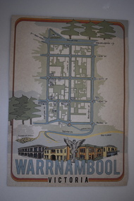 Warrnambool and District Historical Society Inc.
Document, Ella Webb, Warrnambool artist, Street Walks of Warrnambool, 2018
This is a tourist guide to Warrnambool produced by a local artist, Ella Webb, in conjunction with the Warrnambool and District Historical Society. It includes a sketch map showing the location of some points of interest – buildings and sites of historical interest, places of interest that are no longer existing, some natural features (mainly along the coast) and some information about incidents and people in the past. It is an attractive broadsheet that is a useful guide for visitors to Warrnambool. This sheet is of interest as a modern-day tourist map produced in an artistic fashion by a local Warrnambool artist.This is a single sheet of thick paper printed on both sides in green, brown, yellow and beige tonings. One side of the sheet has sketches of buildings and places of interest and printing and the other side has a sketch map of some of the main streets of Warrnambool and some of its attractions. -
![An account of the English colony in New South Wales : with remarks on the dispositions, customs, manners, &c. of the native inhabitants of that country, to which are added, some particulars of New Zealand / compiled, by permission, from the Mss. of Lieutenant-Governor King by David Collins [Volume 1]](/media/collectors/550653872162f11fb04854aa/items/575ba01ad0cdd1229c1f675d/item-media/57600f26d0cdd11990766530/item-fit-380x285.jpg) Kew Historical Society Inc
Kew Historical Society IncBook, State Libraries of South Australia, An account of the English colony in New South Wales : with remarks on the dispositions, customs, manners, &c. of the native inhabitants of that country, to which are added, some particulars of New Zealand (Vol.1), 1971
[Adelaide : Libraries Board of South Australia, 1971] 2 v. : maps (part col.), plates (part col.) ; 28 cm. Facsimile of: London : T. Cadell jun. and W. Davies, 1798. Includes an account of a voyage performed by Captain Flinders and Mr. Bass abstracted from the journal of Mr. Bass. Volume 1non-fictionnew south wales - descriptions and travel, new zealand - descriptions and travel -
 Warrnambool and District Historical Society Inc.
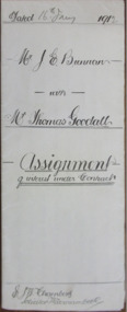
Document - J E Brennan & Thomas Goodall Assignment of Interest 1912, 1912
Tait collection: item 62 of 62 This 1912 document is an agreement made between John Brennan, a farmer from Laang and Thomas Goodall, a law clerk from Warrnambool. The document shows that Thomas Goodall has given John Brennan £5 and Brennan has agreed to pass over to Goodall a 218 acre property in Laang. Brennan also agreed to pay a debt of £10-19-4 to Thomas Goodall by monthly instalments. Thomas Goodall was the law clerk for several lawyers in Warrnambool at the beginning of the 20th century and he was also the manager of the Warrnambool office of the lawyer, Ernest Chambers who had legal offices in Koroit and Port Fairy at the same time (end of 19th century and beginning of the 20th century). This document was in the possession of Ernest Chambers and it has been passed down to successive lawyers occupying the legal premises in Kepler Street where it was located in 2014 (former premises of the law firm of Mackay Taylor). This document is of some interest as it gives details of a business transaction between Thomas Goodall and John Brennan, both residing in the Warrnambool area early in the 20th century. This is a piece of buff-coloured paper folded in two to make four pages. There is typed and handwritten material on two sides of the paper. This is a 1912 document called an Assignment of Interest Under Contract with John Brennan agreeing to pay his financial debts to Thomas Goodall. The document contains the signatures of John Brennan and Thomas Goodall. Part of one page of the writing is in pencil. There is also a separate receipt sheet which is a receipt for £5 paid by Thomas Goodall to John Brennan. A yellow duty stamp is attached to this receipt. Dated 16 Jany 1912 Mr J E Brennan with Mr Thomas Goodall Assignment of Interest under Contractjohn brennan, thomas goodall, ernest chambers, warrnambool -
Whitehorse Historical Society Inc.
Document, Walker Estate Mitcham, 8/10/1938 12:00:00 AM
Auction brochure for 'Beautiful brick residence' of 9 rooms, with 1 1/2 acres of grounds, subdivided into 12 sites for brick residences, Saturday 8th October 1938.Auction brochure for 'Beautiful brick residence' of 9 rooms, with 1 1/2 acres of grounds, subdivided into 12 sites for brick residences, Saturday 8th October 1938, by order of the Executors of the late E. E. Walker. Frontages to Mitcham Road, Agra Street, Simla Street and Meerut Street. Auctioneers: Edward Haughton Pty Ltd and Drake & Co. Original copy framed, located in Map Drawer.Auction brochure for 'Beautiful brick residence' of 9 rooms, with 1 1/2 acres of grounds, subdivided into 12 sites for brick residences, Saturday 8th October 1938.walker, edgar edwardes, walker estate, mitcham road, mitcham, agra street mitcham, simla street mitcham, meerut street mitcham, drake & co., edward haughton pty ltd -
 Bendigo Historical Society Inc.
Document - GOLDEN GULLY ALLUVIAL WORKINGS
Golden Gully alluvial workings, Diamond Hill area, site number 1.1. Document has map/grid references, parcel number and location - runs along Woodward Road. History from 1851 to 186 detailed. . Information from David Bannear's Bendigo goldfields survey.