Showing 10477 items
matching lander
-
 Whitehorse Historical Society Inc.
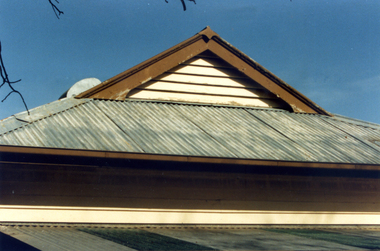
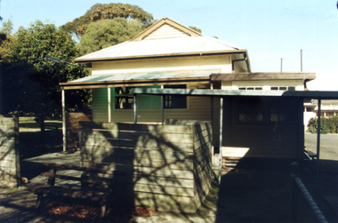
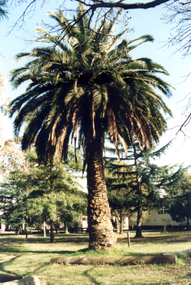
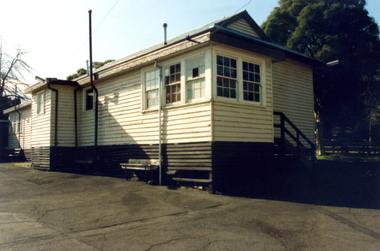
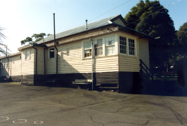
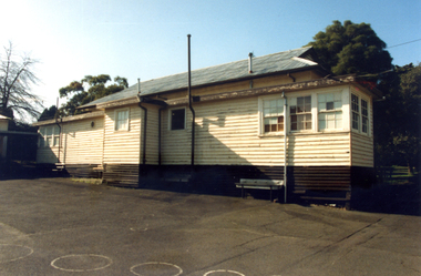
Photograph, Forest Hill State School, 1/08/1993 12:00:00 AM
School closed , demolished and land sold for housing .Coloured Photo of Forest Hill State School No. 4251.Springvale Road, Forest Hill. Since demolished. Part of a group of 24.forest hill state school. no. 4251 -
 Whitehorse Historical Society Inc.
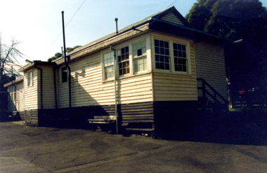
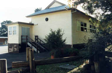
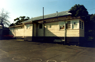
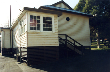
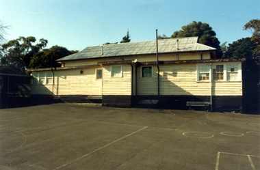
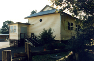
Photograph, Forest Hill State School, 1/08/1993 12:00:00 AM
School closed , demolished and land sold for housing .Coloured Photo of Forest Hill State School No. 4251.Springvale Road, Forest Hill. Since demolished. Part of a group of 24.forest hill state school. no. 4251, school -
 Whitehorse Historical Society Inc.
Photograph, Forest Hill State School, 1/08/1993 12:00:00 AM
School closed , demolished and land sold for housing .Coloured Photo of Forest Hill State School No. 4251.Springvale Road, Forest Hill. Since demolished. Part of a group of 24.forest hill state school. no. 4251 -
 Whitehorse Historical Society Inc.
Photograph, Forest Hill State School, 1/08/1993 12:00:00 AM
School closed , demolished and land sold for housing .Coloured Photo of Forest Hill State School No. 4251.Springvale Road, Forest Hill. Since demolished. Part of a group of 24.forest hill state school. no. 4251, school -
 Whitehorse Historical Society Inc.
Photograph, Forest Hill State School, 1/08/1993 12:00:00 AM
School closed , demolished and land sold for housing .Coloured Photo of Forest Hill State School No. 4251.Springvale Road, Forest Hill. Since demolished. Part of a group of 24.forest hill state school. no. 4251, school -
 City of Ballarat Libraries
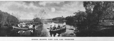
Postcard - Card Box Photographs, Boating on Fairy Land, Lake Wendouree 1910
Evening Shadows, Fairy Land, Lake Wendoureefairy land, lake wendouree, boating, vehicle, people -
 Lakes Entrance Regional Historical Society (operating as Lakes Entrance History Centre & Museum)
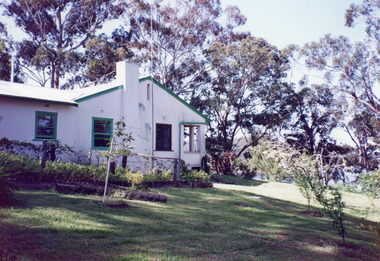
Photograph, 1999
Land became freehold, purchased by Jack Phillips.Colour photograph of a white painted brick residence with corrugated iron roof, sash windows, Set in bushland overlooking Lake Tyers, built on the site of the Mill Point saw mill at Mill Point Toorloo Arm Victoriahouses, heritage study -
 Vision Australia
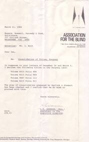
Letter - Text, Letter regarding Consolidation of titles at Kooyong, 11/3/1982
Letter regarding the consolidation of land titles at Kooyong.1 photocopy of typed letterassociation for the blind, corporation records -
 University of Melbourne, Burnley Campus Archives
Pamphlet, The University of Melbourne, Faculty of Land and Food Resources, The University of Melbourne Burnley Campus Graduation Ceremony
Faculty of Land and Food Resources. Change in Facultygraduation, faculty of land and food resources, the university of melbourne -
 Bendigo Historical Society Inc.
Photograph - The Young and Wirth Families at Preston Vale, near the Springs Sedgwick, 1880s-1900s
The Phil Wilkin Collection contains a series of 11 Items. The related items can be found by clicking on the reference link below. The following history of the Young family and their descendants who lived at the Springs is provided by Phil Wilkin. His Great Grandparents were Frances Young and August Wirth. Phil has also provided notes on the Wilkin Family and some history of the gold mining in Sedgwick. Frances Young's parents Joseph and Margaret Young owned the property called "The Old Place, Preston Vale or Wellington Flat" at Sedgwick near the Springs. Joseph Young owned and Managed the Standard Brewery which was located at Campbells Creek during the late 1800’s early 1900’s. Joseph and Margaret are buried in the Harcourt cemetery. In 1880 August Wirth lived at Mosquito Creek (Lake Eppalock, Victoria) when he married Frances Young. In 1902 they moved to part of Joseph Young's property. They milked cows and sold cattle for a living. One of their children Charles Wirth (Phil Wilkin's Grandfather) bought the land in 1935 after his parents had died. Charles Wirth was a councillor and also was president of the Shire of Strathfieldsaye. The "Old Place" was part of the property owned by members of the family. The old house at the Springs was burnt out by bushfire in January 1944 and much of the stonework was later vandalized by campers. The original Coliban Water Works were designed in 1863 by the Irish engineer Joseph Brady. The system included 70 kilometres of open water channels, aqueducts, syphons and tunnels to carry water (by gravity) from the Coliban River at Malmsbury, north to Castlemaine and Bendigo. Sedgwick is a locality in Central Victoria, Australia. It is located in the City of Greater Bendigo. Facilities include a public hall that opened in 1958 and CFA Rural fire station. It was named Upper Emu Creek until 1901 when it was renamed as Sedgwick after British geologist Adam Sedgwick.Thirty Four Photos of Joseph Young's property near "The Springs" on the main Coliban water channel from Malmsbury to the Sandhurst Reservoir in Bendigo. This item contains family history of Joeph's descendant Charles Wirth, who was a councillor for the Shire of Strathfieldsaye. The water race descends through a concrete chute, and continues sharply around the contour of the hills. Once it descended into a syphon across the gully. The are 182 photos in this series and can be found at 8683.1 to 8683.11. The series also includes photos of the surrounding farming land and the remains of an old house. There are also some notes on the pioneers of the district.history, bendigo, coliban water, joseph brady, irrigation, the springs, sedgwick, charles wirth, preston vale, joseph and margaret young, standard brewery campbells creek harcourt, phil wilkin collection -
 The Beechworth Burke Museum Research Collection
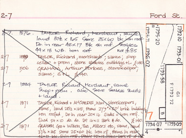
Card (Series) - Index Card, George Tibbits, Ford Street, Beechworth, 1976
George Tibbits, University of Melbourne. Faculty of Architecture, Building and Town & Regional PlanningIndex system that support the research for Beechworth : historical reconstruction / [by] George Tibbits ... [et al]Arranged by street names of BeechworthEach index card includes: street name and number of property, image of property, allotment and section number, property owners and dates of ownership, description of the property according to rate records, property floor plan with dimensions.beechworth, george tibbitsbeechworth, george tibbits -
 Federation University Historical Collection
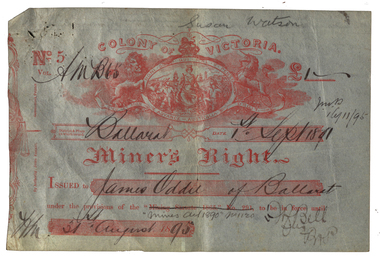
Document - Miner's Right, Colony of Victoria, Miner's Right for the Ballarat Observatory Land in Magpie Street, 1890-1899
The Ballarat Observatory was established by James Oddie. It was later given to the Ballarat School of Mines, then the City of Ballarat.A number of Miners' Rights made out to James Oddie of Ballarat, for a block of land in Magpie Street, Mount Pleasant, used as the Ballarat Observatory. The red 1995 Miners' Right includes land at Dana Street with red writing over it regarding its transferal. The Observatory Registration in No 19578 with the situation of residence area being 'Magpie Street Mount Pleasant 209 feet x 52 feet" The District and Division is Central D Ballarat. The red Miners' Right includes the Magpie Ste Address and "Dana Street allot 3 Sec 52 40 feet and 140 feet in Ballarat Central D". In red ink over the address in written (Ressarell) transferred in favor of Susan Watson 7/1/95 C.H. Stevenson Asst M.R. miner's right, james oddie, ballarat observatory, magpie st, mount pleasant, f. bell, w.a. christy, dana street -
Federation University Historical Collection
Booklet, Education Department Victoria, Victorian Education Department Course of Study of primary Schools: Social Studies, 1954 and 1956
.1) 18 page booklet relating to the Victorian Education Department Course of Study of Primary Schools: Social Studies grades 1 to 6. Topics include family and home, how the community lives and works, Beyond the Neighbourhood (Africa, Canada, New Guinea, India, China, Italy, English factory town), The World About Me (School, home, food, clothes), Our Own Land (The Australia Our Ancestors Found - unknown interior, sheep, riches from underground, water, grain, cows, meat, tropics, tall timbers, manufacture, Melbourne, travel), The Land of Our Fathers (British Descent, From other Countries .2) Victorian Education Department Course of Study of primary Schools: Social Studies, Grades VII and VIII 6 page printed bookleteducation department, social studies, education -
 Bendigo Historical Society Inc.
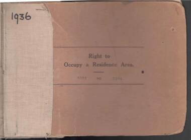
Book - RIGHT TO OCCUPY RESIDENCE AREA COLLECTION: REGISTER 1936
COLLECTION OF RIGHT TO OCCUPY A RESIDENCE AREA -LAND (RESIDENCE AREAS ) Act 1935 / thick cardboard book -cloth and string binding / written on front in texter '1936' / numbers 5001 to 5100 / inside - stubs of documents showing Granted to , of, period, Date of Right , Description of Land , Allotment, Section, City, Town , Borough , Township of , Parish of , Authorised Person . Rubber stamps show The interest of this Right has been transferred to /one stub shows Department of Lands and Survey note on Bendigo Historical Society Catalogue Sheet dated 12.6.2008 All buts completed and original application forms removed. Note -forms were originally in triplicate on one page with serrations for removal of two parts; butts remain .Residence areas in Central Goldfields.Bendigo City Council - Acquisition 1990organization, government, official -
 Bendigo Historical Society Inc.
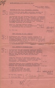
Document - MISS G ALICE JONES COLLECTION: ACCOUNT
North Hustlers Gold Mining Co. N. L. to Miss G. Alice Jones. Pink paper dated Apl 2 to 13, Apl 2 to Sep 12, Apl 18 to Sep 12 1940 and 26 September 1940. Re Highmore to you (R. B. Stanistreet nominee) Instructions for short sale agreement, transfer of residence area. Re East Moon Co. to you - Leases. Costs of transferring four Gold Mining Leases. Re Mrs. Jeffrey's Residence Area. Costs involved in providing for purchase of Mrs Jeffrey's residence area, the purchase of Penberthy's land by Mrs. Jeffrey and the removal of Mrs. Jeffrey's house to that land. Total Cost £20.13.0. "R693 del 26/9/1940" written in the top left corner.miss g alice jones - solicitor - account, north hustlers gold mining co n l, mrs highmore, r b stanistreet, east moon co, mrs jeffrey, penberthy -
 Bendigo Historical Society Inc.
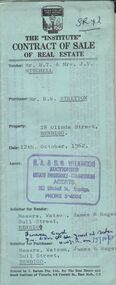
Document - H.A. & S.R. WILKINSON COLLECTION: CONTRACT OF SALE
Contract of sale of real estate between Mr. R.T. & Mrs J.V. Mitchell (Vendor) and Mr. R.W. Stretton (purchaser) for property at 28 Olinda Street, Bendigo dated 12th October, 1962. Solicitor for vendor: Messrs Watson, James & Rogers - Bull Street Bendigo. Solicitor for purchaser: Messrs. Watson, James & Rogers of Bull Street, Bendigo. Sale of piece of land part of Crown allotment 6, section 68c land described in Certificate of title volume 4472, folio 399, together with a right of carriageway over the road coloured brown on the map drawn on the said certificate of title, together with all floor coverings, blinds, curtains, electric light fittings and shades, gas fire and gas copper. Price 1,850 pounds.organization, business, h.a. & s.r wilkinson real estate -
 Bendigo Historical Society Inc.
Document - CONNELLY, TATCHELL, DUNLOP COLLECTION: LEGAL PAPERS, 1919 1920
Document. Various legal papers. 1 - 1919 - Hands E W (Butcher Bendigo) re costs Morrison. 2 - 1919 - Horsfield Taylor deceased estate. Re costs Mrs Horsfield. 3 - 1920 - Hocking James (Frankston) re costs. Federal Land Tax & Sunda Singh. 4 - 1919 - Howe J B (Bridgewater) re costs Land Tax. 5 - 1919 - Grabasch Mrs J O (Pier Millan) re costs Reed Bros. 6 - 1919 - 1920 - Grylls, Mrs E P (Bendigo) re costs Will. 7 - 1920 - Coy F C T (Manager - Farmers & Citizens Trustees Company Bgo Ltd. Charing Cross Bendigo) re costs Wm Simpson Estate.cottage, miners, connelly, tatchell & dunlop, hands e w, morrison, horsfield taylor, horsfield mrs, hocking james, sunda singh, howe j b, grabasch mrs j o, reed bros, grylls mrs e p, coy f c t, farmers & citizens trustees company bgo ltd, simpson wm -
 Victorian Aboriginal Corporation for Languages
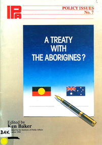
Book, Ken Baker, A treaty with the Aborigines?, 1988
A time for reconciliation / Bob Hawke -- Treaty is a recipe for separatism / John Howard -- A treaty for land justice and self-determination / Janine Haines -- Why a treaty? / Galarrwuy Yunupingu -- Aborigines are Australian, too / Bob Liddle -- Fallacies weaken the case for a treaty / Geoffrey Blainey -- Why whites also need an Aboriginal treaty / Roberta Sykes -- The quest for Aboriginal sovereignty / Hugh Morgan -- Legal and constitutional considerations / Mark Cooray -- Australia as terra nullius / Peter van Hattem -- Canada: towards Aboriginal self-government? / Jean Chretien -- American Indian treaties: historic relics / Peter Samuel -- The long aftermath of Waitangi / Antomy C. Turner -- Appendix 1: The Barunga statement -- Appendix 2: Preamble to the ATSIC Bill -- Appendix 3: Press attitudes to a treaty -- Appendix 4: Aboriginal population and landmaps, b&w photographsrace relations, racism, government relations, treaties -
Surrey Hills Historical Society Collection
Folder of information, Libby Cavenagh's 1990 building census of Wandsworth Road, Surrey Hills, 1990
Libby Cavenagh was Secretary of the Surrey Hills Historical Society. She completed this study as part of a Diploma of Local History she was undertaking at the University of New England. At the time she lived in Wandsworth Road.This is a unique analysis of the housing stock of a complete street at one point in time. Many of the houses have been altered since the study was completed and quite a number have been demolished.Blue folder of A4 size. This contains an analysis of each house in Wandsworth Road in 1990 with details regarding building style, approximate age, materials used, fence design, presence or absence of a garage or carport and some comment on the garden elements. For most entries there is a coloured photo taken from the street. For some there are photocopies of real estate advertisements. There are a number of appendices including s a map of the breakdown of styles and materials; date of construction and other information from the Camberwell Building registers 1890-1934; entries re owners from Sands & McDougall directories, 1897-1937; map from Land Titles Office showing sub-division information; land auction advertisements; information re W J Vine; list of builders; references.wandsworth road, libby cavenagh -
 City of Kingston
Photograph - Black and white, 20 December 1945
This aerial photograph depicts the changing landscape of Cheltenham and Highett since WWII. Photographed in 1945, there is a mix of urban dwellings and industrial development and precedes the major transformation of Cheltenham with the development of the Southland shopping centre in the 1960s and expansion in the 1990s.A large part of Cheltenham was originally established as a rural market gardening community. The railway line and station brought urban development to the area and in the north, the Highett area was dominated by the Highett Gas Works. Cheltenham became a major destination for shopping in the 1960s with the opening of Southland.Aerial photograph taken in 1945 of Cheltenham and Highett within the City of Kingston. The image includes the Highett Reserve, (top right), the Methodist Children Homes (now Southland), Nepean Highway and Jamieson Street. Highett Gas Works is visible in the top left and the land now named William Fry Reserve at the intersection of Bay Road and Nepean Highway. A visible large parcel of land on the corner of Bay Road and Nepean Highway was developed in the 1990s as the west side addition to Southland. The densely vegetated area in the upper right sector of the image is now dense with housing. Tulip Grove, Heather Grove and Gilford Street are visible bottom left. This image is possibly from the collection of aerial photographs commissioned by the Department of Crown Lands and Survey and taken by Adastra Airways.Black ink: 57252 White lettering: VIC-10 57252 20.12.45 [lens information indecipherable] PROJ. No.5 MELB. METROP AREA Black pencil: 80highett, cheltenham, highett gas works, urbanisation -
 City of Kingston
Photograph - Black and white, 20 December 1945
This aerial photograph depicts the changing landscape of Cheltenham and Highett since WWII. Photographed in 1945, there is a mix of urban dwellings and industrial development and precedes the major transformation of Cheltenham with the development of the Southland shopping centre in the 1960s and expansion in the 1990s.A large part of Cheltenham was originally established as a rural market gardening community. The railway line and station brought urban development to the area and in the north, the Highett area was dominated by the Highett Gas Works. Cheltenham became a major destination for shopping in the 1960s with the opening of Southland.Aerial photograph taken in 1945 of Cheltenham and Highett within the City of Kingston. The image includes the Highett Reserve, (top right), the Methodist Children Homes (now Southland), Nepean Highway and Jamieson Street. Highett Gas Works is visible in the top left and the land now named William Fry Reserve at the intersection of Bay Road and Nepean Highway. A visible large parcel of land on the corner of Bay Road and Nepean Highway was developed in the 1990s as the west side addition to Southland. The densely vegetated area in the upper right sector of the image is now dense with housing. Tulip Grove, Heather Grove and Gilford Street are visible bottom left. This image is possibly from the collection of aerial photographs commissioned by the Department of Crown Lands and Survey and taken by Adastra Airways.Black type: Reverse lettering VIC-10 57252 20.12.45 [lens information indecipherable] PROJ. No.5 MELB. METROP AREA White lettering: Reverse writing 57252cheltenham, highett, highett gas works, urbanisation -
 City of Moorabbin Historical Society (Operating the Box Cottage Museum)
Document, laminated List of Pioneers Moorabbin Parish, c1985
This list shows the names of the Pioneer settlers with the amount of Acres, the date purchased from The Crown and the Lot or Portion Number in the Land of the Henry Dendy Special Survey of Brighton 1841, in the County of Bourke , Victoria. The Squatters ,who arrived in the area first, used the land for grazing sheep and cattle. The Squatters had the right to graze unoccupied Crown land for ₤10 per year rental and a per capita payment for animals grazed. They could develop , improve and clear the land for the purpose of the tenancy but ownership was not permitted. When the land became useful The Crown put it on the market and the developers took over whilst the Squatters lost the improved land, dwellings and out buildings, there being no compensation paid. Squatters named John and Thomas Martin 1840-41; Richard and John King 1840- 1854 ; M.N.M.Moysey and M.J.Bickford 1841-1852 ; James McMahon 1846-1853 ; Daniel MacKinnon 1839- 1840. The 5120 Acres of the Henry Dendy Special Survey 1841were divided into approx. 83 Portions / Lots with varying acreage . Josiah Holloway, a speculator purchased 625 acres of the King Brothers run and re-sectioned the land into 2 acre Lots for Sale as market gardens. It was called The Two Acre Village later known as Cheltenham. A List of the names of The Pioneers in County of Burke Victoria c1841-1887 compiled by Lesley A. Schumer in 1985 A 3 Laminated display on wall in room 2 THE PIONEERS, Signed L.A. Schumer moorabbin, brighton, cheltenham, bentleigh, market gardeners, pioneers, early settlers, dendy henry, henry dendy's special survey 1841, squatters, king john, martin john, mcmahon james, two acre village, holloway josiah, were jonathan binn, grazing, cattle, sheep, market gardens, -
 Ringwood and District Historical Society
Map - Public Land Sale by Thomas Ham, 2000 Acres for Sale - Crown Sections 20, 23, 24 - Ringwood, Victoria - 1855
Two 1850s surveyor's maps on cardboard backing showing area from Melbourne extending East beyond Bulleen and Nunawading. Detailed description of lots for sale and navigational directions to the property from Richmond by Thomas Ham, Victorian public servant, map maker, publisher, lithographer and original Ringwood land owner. Inset map enlarging area between Yarra River and Dandenong Creek, with southern boundary of allotments later forming part of Oban Road, North Ringwood.TRANSCRIPT: "This really valuable Property is now offered to the public for sale, in lots to suit purchasers at the Iow rate of £1 per Acre for 80 acres and upwards, and £1.10s per Acre for any smaller portion. Terms of payment Half Cash, Balance in 6 and 12 months, bearing 8 per cent interest. The Estate is well wooded with Gum, Cherry Tree and Stringy Bark, with Wattle in the valleys of the several creeks. Every lot is Staked and Trenched at the corners marked on the Plan thus - The Surveyor has carefully sub-divided the Property, in order to give every Farm a Creek for Water, Valley for Cultivation, and Hills for House and Grass Paddock. The ROADS have been very carefully laid out so as to give a firm, well drained, and nearly level road to each Homestead. Intending purchasers can readily find the property by the following directions, viz: Start from Richmond Bridge, at Hawthorne, then take the left-hand road to KEW. When at the "Woodman Inn", take the Cotham Road to the right, bearing due east, keep this Road, passing Trainor's "White Horse" Inn, and before you leave the fences, you will see calico bills (see margin) nailed to the Trees on the bush track leading to the Upper Yarra country, follow the Bills till you come to the SOUTH boundary line of the Property, which bears East and West (see Plan) where you will see Bills nailed up "THIS PROPERTY FOR SALE, etc." The Bills from Town lead direct to where Mr. Jull is erecting his Store, and arrangements have been made with him to show the lots to intending purchasers free of charge. At the respective corners of the lots the Bills are nailed up double, with numbers to denote the lot, and that the corner stake is adjacent. Any parties wishing to proceed to the property by way of BULLEEN will find Bills nailed on the Trees, commencing at the NEW INN, at "Wilson's Slip Rail." Keep this Track till you come to the Log Bridge, over the Deep Creek at Bloxhome's Paddock; go through the land now being cleared; keep the track over the hill till you come to an Iron House, you will then be on the property, which Iies to the North and East as per Plan. Follow the Bills till you come to Mr. Jull's Store, etc. etc. Further particulars can be had from the Agent for the Property. THOMAS HAM. "