Showing 5216 items
matching position
-
 Eltham District Historical Society Inc
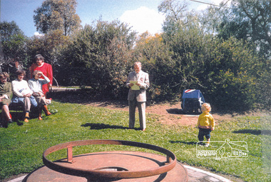
Photograph, Fitting of Time Capsule, Eltham, 1987, 1987
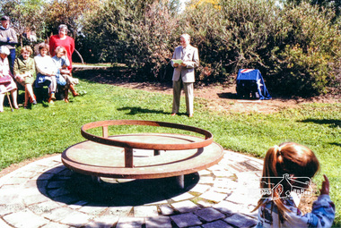
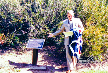
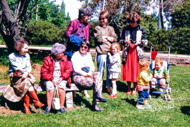
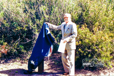
In November 1985 a monument was installed near the corner of Main Road and Pitt Street in Eltham, within the gardens at the front of what is now the Eltham Community and Reception Centre. This monument commemorates Victoria's 150th anniversary and the former location of the Eltham Town Centre, which existed along this section of Main Road, then known as Maria Street. Beneath the site is a time capsule to be opened in the year 2035. A plaque was also erected at this site in October 1987 to commemorate the Shire of Eltham Historical Society's 20th anniversary. The main feature of this monument is a ?tyring disc?, a blacksmith?s implement that was found on this site. This consists of a large iron disc that was used as a platform for fitting iron tyres (like the one shown on top of the platform) to wooden spoked cart wheels. The local blacksmith and wheelwright worked together to assemble the wheel, which was clamped to the platform placed close to the fire. The red hot iron hoop, previously forged to the correct size was lifted with tongs by the blacksmith over the outside of the rim, then hammered down amid flames from the scorching timber. The wheelwright drenched the tyre with cold water as soon as it was in position. A clamp placed on the naff (hub) and screwed down tightly kept the spokes at a constant angle as the tyre cooled. An even pressure from the contracting tyre tightened the joints at each end of the spokes and formed a vice-like grip, which would last for the life of the wheel.Four colour photographs (laser printed on paper); two showing the fitting of the time capsule into the monument and two showing Joh Ebeli during the dedication presentation.eltham, joh ebeli, time capsule -
 Eltham District Historical Society Inc
Photograph, Fitting of Time Capsule, Eltham, 1987, 1987
In November 1985 a monument was installed near the corner of Main Road and Pitt Street in Eltham, within the gardens at the front of what is now the Eltham Community and Reception Centre. This monument commemorates Victoria's 150th anniversary and the former location of the Eltham Town Centre, which existed along this section of Main Road, then known as Maria Street. Beneath the site is a time capsule to be opened in the year 2035. A plaque was also erected at this site in October 1987 to commemorate the Shire of Eltham Historical Society's 20th anniversary. The main feature of this monument is a ?tyring disc?, a blacksmith?s implement that was found on this site. This consists of a large iron disc that was used as a platform for fitting iron tyres (like the one shown on top of the platform) to wooden spoked cart wheels. The local blacksmith and wheelwright worked together to assemble the wheel, which was clamped to the platform placed close to the fire. The red hot iron hoop, previously forged to the correct size was lifted with tongs by the blacksmith over the outside of the rim, then hammered down amid flames from the scorching timber. The wheelwright drenched the tyre with cold water as soon as it was in position. A clamp placed on the naff (hub) and screwed down tightly kept the spokes at a constant angle as the tyre cooled. An even pressure from the contracting tyre tightened the joints at each end of the spokes and formed a vice-like grip, which would last for the life of the wheel.Colour photograph (one of four)eltham, joh ebeli, time capsule -
 Eltham District Historical Society Inc
Photograph, Fitting of Time Capsule, Eltham, 1987, 1987
In November 1985 a monument was installed near the corner of Main Road and Pitt Street in Eltham, within the gardens at the front of what is now the Eltham Community and Reception Centre. This monument commemorates Victoria's 150th anniversary and the former location of the Eltham Town Centre, which existed along this section of Main Road, then known as Maria Street. Beneath the site is a time capsule to be opened in the year 2035. A plaque was also erected at this site in October 1987 to commemorate the Shire of Eltham Historical Society's 20th anniversary. The main feature of this monument is a ?tyring disc?, a blacksmith?s implement that was found on this site. This consists of a large iron disc that was used as a platform for fitting iron tyres (like the one shown on top of the platform) to wooden spoked cart wheels. The local blacksmith and wheelwright worked together to assemble the wheel, which was clamped to the platform placed close to the fire. The red hot iron hoop, previously forged to the correct size was lifted with tongs by the blacksmith over the outside of the rim, then hammered down amid flames from the scorching timber. The wheelwright drenched the tyre with cold water as soon as it was in position. A clamp placed on the naff (hub) and screwed down tightly kept the spokes at a constant angle as the tyre cooled. An even pressure from the contracting tyre tightened the joints at each end of the spokes and formed a vice-like grip, which would last for the life of the wheel.Four colour photographs (laser printed on paper); two showing the fitting of the time capsule into the monument and two showing Joh Ebeli during the dedication presentation.eltham, joh ebeli, time capsule -
 Eltham District Historical Society Inc
Folder, Ewen Cameron
Cameron, Ewen Hugh, M.L.A.., J.P. Kangaroo Ground, is a native of Inverness-shire, Scotland, and came out to Victoria in the ship Hurricane, 13th September, 1853. After he had been engaged for two years int eh building trade in Melbourne in company with is two brothers, since dead, he carried on storekeeping for several years at the Caledonia gold diggings. In 1860 he purchased 80 acres of land at Kangaroo Ground, where he now resides, and later 160 aces of lands at Yarra Flats; he has also 600 acres rented, and is occupied in grazing and agricultural pursuits generally. Mr Cameron holds the prize given by the agricultural society for the best-kept farm in the district. In 1863 he was elected a member of the shire council, and has held the position to represent the Castlemaine mining board, which office he still holds, and in 1874, he was elected to a seat in the Legislative Assembly for the County of Evelyn, which seat he still retains, having the contested the constituency five times, and been elected once without opposition. from "Victoria and its Metropolis: Past and Present" written in 1888 by Alexander Sutherland. Chapter 19, "The Upper Yarra District" pages [402] - 415. Includes descriptions of some townships and short biographies of local residents. Page 405 Folder of information on Ewen Hugh Cameron, MP, Kangaroo Groundewen cameron, pigeon bank -
Eltham District Historical Society Inc
Folder, J.D. and E. Cameron, 1850s
Cameron, Ewen Hugh, M.L.A.., J.P. Kangaroo Ground, is a native of Inverness-shire, Scotland, and came out to Victoria in the ship Hurricane, 13th September, 1853. After he had been engaged for two years int eh building trade in Melbourne in company with is two brothers, since dead, he carried on storekeeping for several years at the Caledonia gold diggings. In 1860 he purchased 80 acres of land at Kangaroo Ground, where he now resides, and later 160 aces of lands at Yarra Flats; he has also 600 acres rented, and is occupied in grazing and agricultural pursuits generally. Mr Cameron holds the prize given by the agricultural society for the best-kept farm in the district. In 1863 he was elected a member of the shire council, and has held the position to represent the Castlemaine mining board, which office he still holds, and in 1874, he was elected to a seat in the Legislative Assembly for the County of Evelyn, which seat he still retains, having the contested the constituency five times, and been elected once without opposition from "Victoria and its Metropolis: Past and Present" written in 1888 by Alexander Sutherland. Chapter 19, "The Upper Yarra District" pages [402] - 415. Includes descriptions of some townships and short biographies of local residents. Page 405 Folder of information on J D and E Cameron, land purchasers, Eltham, c.1850sj.d cameron -
 Cheese World Museum
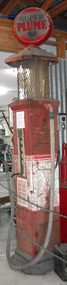
Petrol bowser, Super Plume, c1927
The Uebergang family came from Silesia to Australia in 1848 and were early settlers in the Allansford area. The sons and other descendants also purchased farms in the area. The Percy Uebergang family lived at Tooram Park, Allansford from 1912 until 1992. Percy and Myrtle Uebergang's children were twins, Ray and Joyce born in 1926 who lived at Tooram Park until their deaths, Ray in 1986 and Joyce in 1992 after which the property was sold. Neither Ray nor Joyce married and following the death of her brother Joyce set up the Ray and Joyce Uebergang Foundation which supports the local community. The collection of items from their property was put into store for a number of years before being given into the care of the Cheese World Museum. The family often re-used, recycled and repaired items and examples can be seen in the museum. This petrol pump is part of the collection of items given into the care of the Cheese World Museum. As with many rural families the Uebergangs had bulk fuel supplies on-farm. The bowser was used to refuel farm machinery. Mobil's Super Plume petrol was one of the many brands of petrol available from the late 1920s. No electricity was required to work this bowser as it was gravity fed. The amount of petrol was selected by the position of the front lever. Petrol was then pumped into the bowl by the handle on the side of the bowser and gravity=fed to the vehicle. This petrol bowser is an example of a 1920s petrol bowser.allansford, uebergang, vacuum oil company, super plume petrol bowser, petrol bowsers, farm machinery -
 Flagstaff Hill Maritime Museum and Village
Domestic object - Ornament, Early 20th Century
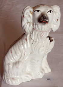
Staffordshire dog figurines are matching pairs of pottery spaniel dogs, standing guard, which were habitually placed on mantelpieces in 19th-century homes. Mainly produced by Staffordshire pottery factories, these earthenware figures were also made in other English counties and Scotland. They are also known as hearth spaniels or fireplace dogs as they were positioned on top of the mantelpiece. Many other breeds were produced, particularly the greyhound, though the spaniels were especially popular and this is attributed to royalty favouring the King Charles Spaniel breed. In Scotland, they have colloquially been termed 'Wally dugs.' and were manufactured in bulk at potteries in places such as Pollokshaws in Glasgow and Portobello near Edinburgh. Though the most popular, the dogs were only one of many types of Staffordshire figures; other animals and human figures of various kinds were also popular. Staffordshire dogs are nowadays collectors’ items and since the 1720s, spaniels had been produced by various pottery factories in Staffordshire. The quality of the modelling and painting of the Staffordshire dogs may differ from factory to factory. As the popularity of the figurines increased towards the end of the 19th century, the quality began to decline. Thousands were manufactured but originals in good condition and their correct pairs are now uncommon. These figures continued to be made until the 1920s and early models are of better quality. However, reproductions were still being manufactured in 2009.Early 19th century pair of Staffordshire dogs used as a mantle place display however given their damaged condition and being of a later provenance have little historic or monetary value. Ceramic white dog, figurine one of a pair, with painted face and collar. Both are nearly identical except one sits to the left while the other sits to the right.Noneflagstaff hill, warrnambool, shipwrecked coast, flagstaff hill maritime museum, maritime museum, shipwreck coast, flagstaff hill maritime village, great ocean road, ornament, ceramic ornament, dog ornament -
 Flagstaff Hill Maritime Museum and Village
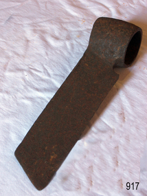
Tool - Froe, Late 19th to Early 20th century
A froe was used for splitting, or riving, wood in the early days and was a skill practiced by craftsmen who made boards, shingles, c lapboards, fences, basket splints, chair parts, wagon spokes, lath, and more. Our ancestors used axes, gluts or wedges, froes, draw knives and spelk planes for splitting wood. The froe was designed in many sizes and designs for splitting timber. It is typically an L-shaped tool made up of a wedge-shaped blade with a dull, but not blunt, knife edge and a wood handle. Blades were usually straight with a socket forged at one end for a handle, but curved blades were also made. Most handles were round and tapered and were inserted up through this socket. But some froes had eyes similar to those on axes for handles that were wedged. The froe handle is held in an upright position in one hand while the other hand drives the top of the blade downward with a wood froe club or mallet. After a split is started, the froe is wiggled downward to lengthen it until the split is complete. Most old froes were hand forged, but they were also available in many catalogues. The 1873 D.R. Barton American catalogue offered straight froes at 12 1/2 cents per inch. You can still buy new froes from many tool manufacturers today.A tool that has not changed in design or use since its inception several hundred years ago to split timber for various uses.Froe, also called cooper's froe or stave froe, without handle.Noneflagstaff hill, warrnambool, flagstaff-hill, flagstaff-hill-maritime-museum, maritime-museum, shipwreck-coast, flagstaff-hill-maritime-village, froe, cooper's froe, stave froe, wood splitter, carpenders tools, coopers tool, splitting timber -
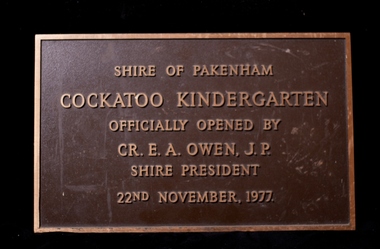 Cockatoo History & Heritage Group
Plaque, Cockatoo Kindergarten - Official Opening Plaque
In 1977 residents of Cockatoo built a kindergarten in McBride Street Cockatoo to service the growing population in the area. The building was officially opened on the 22nd of November of that year. Residents formed a Co-op, raised all the money to build the kinder along with lawn bowls and tennis sporting facilities for the town. No small feat, let alone for a town with a population of around 3000. The land was provided by the council for the kinder to use and that was their sole contribution to the building of the kinder. The unique building, was designed by Richard Allen and depicted a children's carousel. The design was to provide a feeling of enjoyment and friendship to the children who used the building. The large glass windows that were installed on the north-eastern side of the building made up 1/3 of the exterior wall. This overlooked the playground of the kinder making it easy to see the children at play from inside. The site of the building is in a dominant position and is highly visible to all who travel through Cockatoo. It was used as a child care facility right up until 2005. The kindergarten has recently been granted heritage listing after Cardinia Council started demolishing the building. The local community were successful in putting a halt to the demolition and saved the building. It will become an integral part of the Cockatoo Ash Wednesday memorial. Details on the fight to save the kinder building can be found at https://sites.google.com/site/cockatoosheritageashwednesday/ Brass Plaque, depicting the opening of the Cockatoo Kindergarten by the Shire of Pakenham Shire President - Cr OwenShire of Pakenham Cockatoo Kindergarten Officially Opened by Cr E A Owen J.P Shire President 22nd November 1977cockatoo, kindergarten opening, -
 Wangaratta RSL Sub Branch
Personal papers, Lieut. A.J Cruise MBE
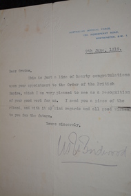
Personal documents and letters belonging to Lieutenant Albert John CRUISE born 13/4/1883 at Nathalia in Victoria. Educated at Geelong College. Enlisted in NSW on 29/8/1914 as Private No 86 1st Battalion. Promoted to L/cpl on 25/7/1915 then Lieutenant on 9/11/1915. He was nominated and appointed a Member of the Order of the British Empire - Military Division for conspicuous services rendered as follows:- 'During the period 16-19 September to 11th November 1918 this officer has shown conspicuous devotion to duty and great gallantry in the performance of that duty. He has organised salvage parties and was instrumental during the advance in September in making German Dumps of HE material available for use in forward positions thus saving time and transport. His work throughout has been characterised by marked individuality and courage in the forward area and has been productive of far reaching results. He served at Gallipoli and the Western Front. Due to pneumonia and enteric he returned to Australia in early 1916 to recuperate and married before returning in August 1916. In September 1919 he returned to Australia on board HMAT Takadaussie (refer item 363) and discharged on 7/11/1919. He later served full time with the CMF from 15/5/1940 - 17/10/1943. He died in 1952Parchment of Appointed to rank 2nd Lieutenant on 9/11/1915 by King George V - Document dated 26/6/1917Four large parchment documents Two Australian Military Forces certificates and one form Five original letters One copy of letter written in French Seven copies of typed letters AIF Military PassCream Parchment with embossed seal, italic script and stamped George R I dated 26/6/1917 and 3/6/1919 Cream Parchment with embossed seal, italic script issued by the Governor General and Commander-in-Chief of the Commonwealth of Australia dated 17/3/1924 and 21/4/1941 AMF Recommendation for Promotion V 84119 Lieut Cruise - form incomplete AMF Certificate of Release from War Service No 11943 - V84199 Lieut Cruise AMF Certificate of Service of an Officer No 33461 -V84119 Lieut Cruise Typed letter dated 13/10/1919 from Commonwealth of Australia Dept of Defence to Lieut Cruise referring to London Gazette extract - Member of the British Empire - Military Division Typed letter embossed with seal dated 9/6/1919 signed W Birdwood Handwritten in blue ink with "Denman Chambers" imprint top right corner letter of reference signed B V Stacy formerly Lieut. Col., Commanding 1st Bn AIF Typed letter with AIF letterhead dated 1/6/1927 Typed letter with The Gallipoli Legion of Anzacs letterhead dated 24/1/1950 Typed copy of letter of gratitude in French dated 18/6/1918 from Military Attache General Pierre de Laguiche - stamped with Statue of Liberty AIF Military Pass dated 25/6/1919 issued to Lieut Cruiselt. a j cruise mbe, ww1 -
 Wangaratta RSL Sub Branch
Personal papers, Lieut. A.J Cruise MBE
Personal documents and letters belonging to Lieutenant Albert John CRUISE born 13/4/1883 at Nathalia in Victoria. Educated at Geelong College. Enlisted in NSW on 29/8/1914 as Private No 86 1st Battalion. Promoted to L/cpl on 25/7/1915 then Lieutenant on 9/11/1915. He was nominated and appointed a Member of the Order of the British Empire - Military Division for conspicuous services rendered as follows:- 'During the period 16-19 September to 11th November 1918 this officer has shown conspicuous devotion to duty and great gallantry in the performance of that duty. He has organised salvage parties and was instrumental during the advance in September in making German Dumps of HE material available for use in forward positions thus saving time and transport. His work throughout has been characterised by marked individuality and courage in the forward area and has been productive of far reaching results. He served at Gallipoli and the Western Front. Due to pneumonia and enteric he returned to Australia in early 1916 to recuperate and married before returning in August 1916. In September 1919 he returned to Australia on board HMAT Takadaussie (refer item 363) and discharged on 7/11/1919. He later served full time with the CMF from 15/5/1940 - 17/10/1943. He died in 1952Parchment of Appointed to rank 2nd Lieutenant on 9/11/1915 by King George V - Document dated 26/6/1917 Parchment of Appointment as a Member of the Military Division of the Order of the British Empire by King George V dated 3/6/1919Four large parchment documents Two Australian Military Forces certificates and one form Five original letters One copy of letter written in French Seven copies of typed letters AIF Military PassCream Parchment with embossed seal, italic script and stamped George R I dated 26/6/1917 and 3/6/1919 Cream Parchment with embossed seal, italic script issued by the Governor General and Commander-in-Chief of the Commonwealth of Australia dated 17/3/1924 and 21/4/1941 AMF Recommendation for Promotion V 84119 Lieut Cruise - form incomplete AMF Certificate of Release from War Service No 11943 - V84199 Lieut Cruise AMF Certificate of Service of an Officer No 33461 -V84119 Lieut Cruise Typed letter dated 13/10/1919 from Commonwealth of Australia Dept of Defence to Lieut Cruise referring to London Gazette extract - Member of the British Empire - Military Division Typed letter embossed with seal dated 9/6/1919 signed W Birdwood Handwritten in blue ink with "Denman Chambers" imprint top right corner letter of reference signed B V Stacy formerly Lieut. Col., Commanding 1st Bn AIF Typed letter with AIF letterhead dated 1/6/1927 Typed letter with The Gallipoli Legion of Anzacs letterhead dated 24/1/1950 Typed copy of letter of gratitude in French dated 18/6/1918 from Military Attache General Pierre de Laguiche - stamped with Statue of Liberty AIF Military Pass dated 25/6/1919 issued to Lieut Cruiselt. a j cruise mbe, ww1 -
 Wangaratta RSL Sub Branch
Personal papers, Lieut. A.J Cruise MBE
Personal documents and letters belonging to Lieutenant Albert John CRUISE born 13/4/1883 at Nathalia in Victoria. Educated at Geelong College. Enlisted in NSW on 29/8/1914 as Private No 86 1st Battalion. Promoted to L/cpl on 25/7/1915 then Lieutenant on 9/11/1915. He was nominated and appointed a Member of the Order of the British Empire - Military Division for conspicuous services rendered as follows:- 'During the period 16-19 September to 11th November 1918 this officer has shown conspicuous devotion to duty and great gallantry in the performance of that duty. He has organised salvage parties and was instrumental during the advance in September in making German Dumps of HE material available for use in forward positions thus saving time and transport. His work throughout has been characterised by marked individuality and courage in the forward area and has been productive of far reaching results. He served at Gallipoli and the Western Front. Due to pneumonia and enteric he returned to Australia in early 1916 to recuperate and married before returning in August 1916. In September 1919 he returned to Australia on board HMAT Takadaussie (refer item 363) and discharged on 7/11/1919. He later served full time with the CMF from 15/5/1940 - 17/10/1943. He died in 1952Parchment of Appointed to rank 2nd Lieutenant on 9/11/1915 by King George V - Document dated 26/6/1917 Parchment of Appointment as a Member of the Military Division of the Order of the British Empire by King George V dated 3/6/1919 Two parchments issued by the Governor General and Commander in Chief of the Commonwealth of Australia Appointed Lieutenant of the Military Forces of the Defence Force of the Commonwealth from 1/1/1920 by Henry William, Baron Forster Appointed Lieutenant of the Reserve Military Forces of the Commonwealth from 13/4/1940 by Alexander Gore Arkwright, Baron GowrieFour large parchment documents Two Australian Military Forces certificates and one form Five original letters One copy of letter written in French Seven copies of typed letters AIF Military PassCream Parchment with embossed seal, italic script and stamped George R I dated 26/6/1917 and 3/6/1919 Cream Parchment with embossed seal, italic script issued by the Governor General and Commander-in-Chief of the Commonwealth of Australia dated 17/3/1924 and 21/4/1941 AMF Recommendation for Promotion V 84119 Lieut Cruise - form incomplete AMF Certificate of Release from War Service No 11943 - V84199 Lieut Cruise AMF Certificate of Service of an Officer No 33461 -V84119 Lieut Cruise Typed letter dated 13/10/1919 from Commonwealth of Australia Dept of Defence to Lieut Cruise referring to London Gazette extract - Member of the British Empire - Military Division Typed letter embossed with seal dated 9/6/1919 signed W Birdwood Handwritten in blue ink with "Denman Chambers" imprint top right corner letter of reference signed B V Stacy formerly Lieut. Col., Commanding 1st Bn AIF Typed letter with AIF letterhead dated 1/6/1927 Typed letter with The Gallipoli Legion of Anzacs letterhead dated 24/1/1950 Typed copy of letter of gratitude in French dated 18/6/1918 from Military Attache General Pierre de Laguiche - stamped with Statue of Liberty AIF Military Pass dated 25/6/1919 issued to Lieut Cruiselt. a j cruise mbe, ww1 -
 Wangaratta RSL Sub Branch
Letter - Personal papers, Lieut. A.J Cruise MBE
Personal documents and letters belonging to Lieutenant Albert John CRUISE born 13/4/1883 at Nathalia in Victoria. Educated at Geelong College. Enlisted in NSW on 29/8/1914 as Private No 86 1st Battalion. Promoted to L/cpl on 25/7/1915 then Lieutenant on 9/11/1915. He was nominated and appointed a Member of the Order of the British Empire - Military Division for conspicuous services rendered as follows:- 'During the period 16-19 September to 11th November 1918 this officer has shown conspicuous devotion to duty and great gallantry in the performance of that duty. He has organised salvage parties and was instrumental during the advance in September in making German Dumps of HE material available for use in forward positions thus saving time and transport. His work throughout has been characterised by marked individuality and courage in the forward area and has been productive of far reaching results. He served at Gallipoli and the Western Front. Due to pneumonia and enteric he returned to Australia in early 1916 to recuperate and married before returning in August 1916. In September 1919 he returned to Australia on board HMAT Takadaussie (refer item 363) and discharged on 7/11/1919. He later served full time with the CMF from 15/5/1940 - 17/10/1943. He died in 1952Parchment of Appointed to rank 2nd Lieutenant on 9/11/1915 by King George V - Document dated 26/6/1917 Parchment of Appointment as a Member of the Military Division of the Order of the British Empire by King George V dated 3/6/1919 Two parchments issued by the Governor General and Commander in Chief of the Commonwealth of Australia Appointed Lieutenant of the Military Forces of the Defence Force of the Commonwealth from 1/1/1920 by Henry William, Baron Forster Appointed Lieutenant of the Reserve Military Forces of the Commonwealth from 13/4/1940 by Alexander Gore Arkwright, Baron GowrieFour large parchment documents Two Australian Military Forces certificates and one form Five original letters One copy of letter written in French Seven copies of typed letters AIF Military PassCream Parchment with embossed seal, italic script and stamped George R I dated 26/6/1917 and 3/6/1919 Cream Parchment with embossed seal, italic script issued by the Governor General and Commander-in-Chief of the Commonwealth of Australia dated 17/3/1924 and 21/4/1941 AMF Recommendation for Promotion V 84119 Lieut Cruise - form incomplete AMF Certificate of Release from War Service No 11943 - V84199 Lieut Cruise AMF Certificate of Service of an Officer No 33461 -V84119 Lieut Cruise Typed letter dated 13/10/1919 from Commonwealth of Australia Dept of Defence to Lieut Cruise referring to London Gazette extract - Member of the British Empire - Military Division Typed letter embossed with seal dated 9/6/1919 signed W Birdwood Handwritten in blue ink with "Denman Chambers" imprint top right corner letter of reference signed B V Stacy formerly Lieut. Col., Commanding 1st Bn AIF Typed letter with AIF letterhead dated 1/6/1927 Typed letter with The Gallipoli Legion of Anzacs letterhead dated 24/1/1950 Typed copy of letter of gratitude in French dated 18/6/1918 from Military Attache General Pierre de Laguiche - stamped with Statue of Liberty AIF Military Pass dated 25/6/1919 issued to Lieut Cruiselt. a j cruise mbe, ww1 -
 Ballarat Heritage Services
Photograph - Colour, Earth Banks, Old Sarum, England, 2016, 01 November 2016
William the Conqueror inherited Old Sarum from the last Saxon king of England. It was an ideal site for a royal castle. It was here in 1070 that William paid off his army after a long and bitter campaign in northern England. It was here in 1086 that he called together all the major landholders in England so they could swear allegiance to him. It was a crucial moment. The Domesday Book was being written, a threatened Viking invasion had only just been averted and William's eldest son was in armed rebellion. Old Sarum was an important place where this Norman king of England held power. In 1794 the Ordnance Survey set out to check the accuracy of the first mapping of Southern England, which had begun ten years earlier. From a point just below Old Sarum Lieutenant William Mudge laid out a base-line 36,574 feet (11,253 metres) long. From each end of the line the positions of distant places were plotted using a huge theodolite made in 1791 by Jesse Ramsden. The accuracy of the process, which was repeated all over England, depended on Jesse Ramsden's craftsmanship and on William Mudge's surveying skill in setting out this first base-line from Old Sarum. The nearer end of Mudge's line is marked by an inscribed stone beside the modern A345 at Old Sarum. ordnance survey, william mudge, jesse ramsden, william the conqueror, old sarum, saxon, 1086, england -
 Ballarat Heritage Services
Photograph - Colour, Earth Banks, Old Sarum, England, 01 November 2016
William the Conqueror inherited Old Sarum from the last Saxon king of England. It was an ideal site for a royal castle. It was here in 1070 that William paid off his army after a long and bitter campaign in northern England. It was here in 1086 that he called together all the major landholders in England so they could swear allegiance to him. It was a crucial moment. The Domesday Book was being written, a threatened Viking invasion had only just been averted and William's eldest son was in armed rebellion. Old Sarum was an important place where this Norman king of England held power. In 1794 the Ordnance Survey set out to check the accuracy of the first mapping of Southern England, which had begun ten years earlier. From a point just below Old Sarum Lieutenant William Mudge laid out a base-line 36,574 feet (11,253 metres) long. From each end of the line the positions of distant places were plotted using a huge theodolite made in 1791 by Jesse Ramsden. The accuracy of the process, which was repeated all over England, depended on Jesse Ramsden's craftsmanship and on William Mudge's surveying skill in setting out this first base-line from Old Sarum. The nearer end of Mudge's line is marked by an inscribed stone beside the modern A345 at Old Sarum. ordnance survey, william mudge, jesse ramsden, william the conqueror, old sarum, saxon, 1086, england -
 Ballarat Heritage Services
Photograph - Colour, Earth Banks, Old Sarum, England, 2016, 01 November 2016
William the Conqueror inherited Old Sarum from the last Saxon king of England. It was an ideal site for a royal castle. It was here in 1070 that William paid off his army after a long and bitter campaign in northern England. It was here in 1086 that he called together all the major landholders in England so they could swear allegiance to him. It was a crucial moment. The Domesday Book was being written, a threatened Viking invasion had only just been averted and William's eldest son was in armed rebellion. Old Sarum was an important place where this Norman king of England held power. In 1794 the Ordnance Survey set out to check the accuracy of the first mapping of Southern England, which had begun ten years earlier. From a point just below Old Sarum Lieutenant William Mudge laid out a base-line 36,574 feet (11,253 metres) long. From each end of the line the positions of distant places were plotted using a huge theodolite made in 1791 by Jesse Ramsden. The accuracy of the process, which was repeated all over England, depended on Jesse Ramsden's craftsmanship and on William Mudge's surveying skill in setting out this first base-line from Old Sarum. The nearer end of Mudge's line is marked by an inscribed stone beside the modern A345 at Old Sarum. ordnance survey, william mudge, jesse ramsden, william the conqueror, old sarum, saxon, 1086, england -
 Ballarat Heritage Services
Photograph - Colour, Earth Banks, Old Sarum, England, 01 November 2016
William the Conqueror inherited Old Sarum from the last Saxon king of England. It was an ideal site for a royal castle. It was here in 1070 that William paid off his army after a long and bitter campaign in northern England. It was here in 1086 that he called together all the major landholders in England so they could swear allegiance to him. It was a crucial moment. The Domesday Book was being written, a threatened Viking invasion had only just been averted and William's eldest son was in armed rebellion. Old Sarum was an important place where this Norman king of England held power. In 1794 the Ordnance Survey set out to check the accuracy of the first mapping of Southern England, which had begun ten years earlier. From a point just below Old Sarum Lieutenant William Mudge laid out a base-line 36,574 feet (11,253 metres) long. From each end of the line the positions of distant places were plotted using a huge theodolite made in 1791 by Jesse Ramsden. The accuracy of the process, which was repeated all over England, depended on Jesse Ramsden's craftsmanship and on William Mudge's surveying skill in setting out this first base-line from Old Sarum. The nearer end of Mudge's line is marked by an inscribed stone beside the modern A345 at Old Sarum. ordnance survey, william mudge, jesse ramsden, william the conqueror, old sarum, saxon, 1086, england -
 Ballarat Heritage Services
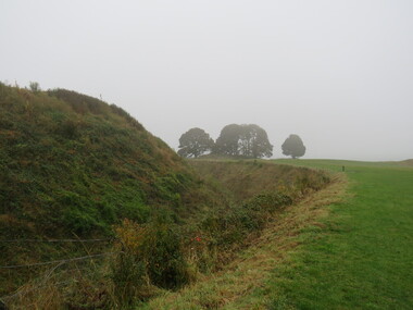
Photograph - Colour, Stonework, Old Sarum, England, English Heritage Site, 01 November 2016
William the Conqueror inherited Old Sarum from the last Saxon king of England. It was an ideal site for a royal castle. It was here in 1070 that William paid off his army after a long and bitter campaign in northern England. It was here in 1086 that he called together all the major landholders in England so they could swear allegiance to him. It was a crucial moment. The Domesday Book was being written, a threatened Viking invasion had only just been averted and William's eldest son was in armed rebellion. Old Sarum was an important place where this Norman king of England held power. In 1794 the Ordnance Survey set out to check the accuracy of the first mapping of Southern England, which had begun ten years earlier. From a point just below Old Sarum Lieutenant William Mudge laid out a base-line 36,574 feet (11,253 metres) long. From each end of the line the positions of distant places were plotted using a huge theodolite made in 1791 by Jesse Ramsden. The accuracy of the process, which was repeated all over England, depended on Jesse Ramsden's craftsmanship and on William Mudge's surveying skill in setting out this first base-line from Old Sarum. The nearer end of Mudge's line is marked by an inscribed stone beside the modern A345 at Old Sarum. ordnance survey, william mudge, jesse ramsden, william the conqueror, old sarum, saxon, 1086, england -
 Ballarat Heritage Services
Photograph - Colour, Stonework, Old Sarum, England, English Heritage Site, 2016, 01 November 2016
William the Conqueror inherited Old Sarum from the last Saxon king of England. It was an ideal site for a royal castle. It was here in 1070 that William paid off his army after a long and bitter campaign in northern England. It was here in 1086 that he called together all the major landholders in England so they could swear allegiance to him. It was a crucial moment. The Domesday Book was being written, a threatened Viking invasion had only just been averted and William's eldest son was in armed rebellion. Old Sarum was an important place where this Norman king of England held power. In 1794 the Ordnance Survey set out to check the accuracy of the first mapping of Southern England, which had begun ten years earlier. From a point just below Old Sarum Lieutenant William Mudge laid out a base-line 36,574 feet (11,253 metres) long. From each end of the line the positions of distant places were plotted using a huge theodolite made in 1791 by Jesse Ramsden. The accuracy of the process, which was repeated all over England, depended on Jesse Ramsden's craftsmanship and on William Mudge's surveying skill in setting out this first base-line from Old Sarum. The nearer end of Mudge's line is marked by an inscribed stone beside the modern A345 at Old Sarum. ordnance survey, william mudge, jesse ramsden, william the conqueror, old sarum, saxon, 1086, england -
 Ballarat Heritage Services
Photograph - Colour, Stonework and well, Old Sarum, England, English Heritage Site, 2016, 01 November 2016
William the Conqueror inherited Old Sarum from the last Saxon king of England. It was an ideal site for a royal castle. It was here in 1070 that William paid off his army after a long and bitter campaign in northern England. It was here in 1086 that he called together all the major landholders in England so they could swear allegiance to him. It was a crucial moment. The Domesday Book was being written, a threatened Viking invasion had only just been averted and William's eldest son was in armed rebellion. Old Sarum was an important place where this Norman king of England held power. In 1794 the Ordnance Survey set out to check the accuracy of the first mapping of Southern England, which had begun ten years earlier. From a point just below Old Sarum Lieutenant William Mudge laid out a base-line 36,574 feet (11,253 metres) long. From each end of the line the positions of distant places were plotted using a huge theodolite made in 1791 by Jesse Ramsden. The accuracy of the process, which was repeated all over England, depended on Jesse Ramsden's craftsmanship and on William Mudge's surveying skill in setting out this first base-line from Old Sarum. The nearer end of Mudge's line is marked by an inscribed stone beside the modern A345 at Old Sarum. ordnance survey, william mudge, jesse ramsden, william the conqueror, old sarum, saxon, 1086, england -
 Ballarat Heritage Services
Photograph - Colour, Stonework, Old Sarum, England, English Heritage Site, 01 November 2016
William the Conqueror inherited Old Sarum from the last Saxon king of England. It was an ideal site for a royal castle. It was here in 1070 that William paid off his army after a long and bitter campaign in northern England. It was here in 1086 that he called together all the major landholders in England so they could swear allegiance to him. It was a crucial moment. The Domesday Book was being written, a threatened Viking invasion had only just been averted and William's eldest son was in armed rebellion. Old Sarum was an important place where this Norman king of England held power. In 1794 the Ordnance Survey set out to check the accuracy of the first mapping of Southern England, which had begun ten years earlier. From a point just below Old Sarum Lieutenant William Mudge laid out a base-line 36,574 feet (11,253 metres) long. From each end of the line the positions of distant places were plotted using a huge theodolite made in 1791 by Jesse Ramsden. The accuracy of the process, which was repeated all over England, depended on Jesse Ramsden's craftsmanship and on William Mudge's surveying skill in setting out this first base-line from Old Sarum. The nearer end of Mudge's line is marked by an inscribed stone beside the modern A345 at Old Sarum. ordnance survey, william mudge, jesse ramsden, william the conqueror, old sarum, saxon, 1086, england