Showing 28488 items
matching street street
-
 Bendigo Historical Society Inc.
Document - GOLDEN SQUARE LAUREL STREET P.S. COLLECTION: FRONT PAGE OF ANNIVERSARY BOOKLET
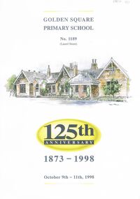
... GOLDEN SQUARE LAUREL STREET P.S. COLLECTION: FRONT PAGE OF...Golden Square Primary School Laurel Street... Square Primary School Laurel Street, No. 1189 ( Laurel Street... Inc. History House 11 Mackenzie Street Bendigo goldfields ...copy of front page of Anniversary Booklet 125th., 'Golden Square Primary School Laurel Street, No. 1189 ( Laurel Street ) ' on top, water colour image of school underneath. Image painted by Stan Thomas ( name underneath) ''125th. Anniversary, 1873 - 1998. October 9th - 11th. 1998', on bottom of cover.bendigo, education, golden square primary school, golden square primary school laurel street, stan thomas, water colour -
 Bendigo Historical Society Inc.
Document - CONNELLY, TATCHELL, DUNLOP COLLECTION: RECEIPT CITY LIVERY & LETTING STABLES
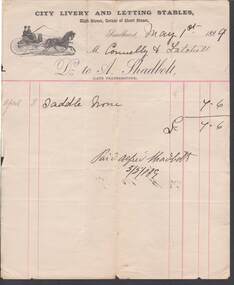
... . On top of invoice 'City Livery & Letting Stables', High Street... Inc. History House 11 Mackenzie Street Bendigo goldfields ...Invoice to Connelly & Tatchell, Dr. to A. Shadbolt. On top of invoice 'City Livery & Letting Stables', High Street, Corner of Short Street, Sandhurst May 1st. 1889. Saddle horse 7/6. On rear of invoice 'Shadbolt, Horse Hire 3/5/89. ( late Featherstone ) in brackets following Shadbolt.business, legal, a. shadbolt -
 Bendigo Historical Society Inc.
Postcard - GLADYS DEAN COLLECTION: POSTCARD, 1906 - 1908
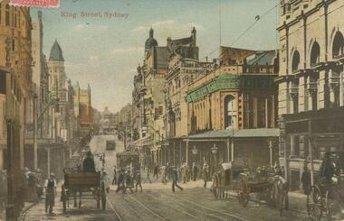
... street with tram tracks down the centre, horse and carts... Inc. History House 11 Mackenzie Street Bendigo goldfields ...Photographic coloured postcard. Image depicts a busy city street with tram tracks down the centre, horse and carts travelling along and people walking along or crossing the road. Many buildings line both sides of the street. The words King Street Sydney are printed in red on the top left hand side.95717postcard -
 Kew Historical Society Inc
Plan - Subdivisional Sale of 11 Villa Sites, East Kew, 1939
... Enfield Street -- Kew (Vic.)... but is now Kew, in the following streets: Burke Road, Enfield Street... this is an example. Subdivision plans -- Kew (Vic.) Enfield Street -- Kew ...Subdivision plans and real estate flyers/brochures reveal a number of aspects of urban development and history. The Kew Historical Society's collection of these plans, as well as advertisements extracted from magazines, cover key aspects of community development and architectural history of Kew and Kew Eat as well as surrounding suburbs. While most of the plans in the collection were gifted to the Society by the former City of Kew, a number of other plans and advertisements have been donated by individuals, of which this is an example.Single page residential subdivision plan advertising house lots for sale, in what was then designated as East Kew but is now Kew, in the following streets: Burke Road, Enfield Street. The flyer includes a smaller locality plan at right. Information on the flyer indicates that the land was previously owned by the Melbourne & Metropolitan Tramways Board.subdivision plans -- kew (vic.), enfield street -- kew (vic.), burke road -- kew (vic.) -
 Warrnambool and District Historical Society Inc.
Documents, WCC Proposed turntable site railway station, 1968; 1989
... at Gilles Street in the Liebig Street precinct. The Warrnambool...Liebig Street, Warrnambool, Victoria, Australia... Street (south of Merri St) Warrnambool great-ocean-road These two ...These two plans are copies and show drawings for a proposed turntable at the Warrnambool Railway Station and railway crossings at Gilles Street in the Liebig Street precinct. The Warrnambool Railway was opened in 1890 and the Warrnambool Railway Station building was erected a few years later. These plans, being copies, are of minor interest as they show plans of some projects in the Warrnambool Railway Station precinct in the latter half of the 20th century.These are two sheets of cream-coloured paper with plans (copies of original) drawn up in black ink. The drawings are fading somewhat and are faint in places. One sheet (.2) has a piece missing from the top left hand corner. .1 ‘Locality Plan of Rail Crossings Liebig St. & Gillies (sic) St.’ .2 ‘Proposed Turntable Site Warrnambool Railway Station’ plans, warrnambool railway, warrnambool rail turntable -
 Ringwood and District Historical Society
Plan - Proposed Ringwood East Railway Station, VR Ringwood-Croydon (Dublin Road) - 1923
... . Surrounding streets include Dublin Road, Patterson Street.... Surrounding streets include Dublin Road, Patterson Street ...Technical drawing of "Proposed Station At 16Mls 38Chs 89Lks (Dublin Road)" inluding boundary line, red shaded platform with station buildings, and green shaded possible future "up" track. Surrounding streets include Dublin Road, Patterson Street, and subsequent hand-written additions of Railway Avenue, Lawrence Grove, Stanley Avenue, Wenwood Street, and Lois Street. Land title details of Patterson Street properties mainly illegible.Scale: 40'=1". Possible future (platform) extension for 8 car trains (and) extension for 10 car trains. -
 Bendigo Historical Society Inc.
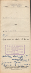
Document - H.A. & S.R. WILKINSON COLLECTION: CONTRACT OF SALE
... of title volume 2708 folio 415 and situate 83 Arnold Street corner... Inc. History House 11 Mackenzie Street Bendigo goldfields ...Contract of sale of land dated 7th April, 1955 between Miss G.M. Lee (seller) and Mr. R.A. Rae for land being part of Crown allotment 240 section E, land described in certificate of title volume 2708 folio 415 and situate 83 Arnold Street corner Uley Street, Bendigo. Together with weatherboard dwelling and all sundry, including all furniture, curtains and blinds. Price 850 pounds.organization, business, h.a. & s.r wilkinson real estate -
 Eltham District Historical Society Inc
Photograph, Looking south along Para Road at intersection of Alma Street and Lees Road, Lower Plenty, c.July 1967, 1967
... Street and Lees Road, Lower Plenty, c.July 1967...alma street... Shire J. McD and 19/7/67. Alma Street and Kett Street Lower... Shire J. McD and 19/7/67. Alma Street and Kett Street Lower ...Old community hall (long wall with row of windows) and Lower Plenty Kindergarten visible at corner of Glenauburn and Para Roads. Packaged in "Filmpro King Size prints Definitely Better EST. 1918" envelope. Pencil notes: 36 shots $2.87 Eltham Shire J. McD and 19/7/67. Alma Street and Kett Street Lower Plenty c.July 1967.Black and white photographalma street, glenauburn road, carisbrook crescent, lees road, lower plenty, lower plenty kindergarten, para road, houses, streets -
 Stawell Historical Society Inc
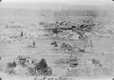
Photograph, Panorama of Stawell from Big Hill 1878, North Scotchmans No6 and No7 and South Cross Mine whims and Poppet Heads
... Patrick Streets and Sloane Street intersection. Back of Royal... Main Street on very right of photo.... Patrick Streets and Sloane Street intersection. Back of Royal ...Scene from Big Hill. Shows Stawell looking to West c 1878 Patrick Streets and Sloane Street intersection. Back of Royal Exchange Hotel Kays Foundry in Wimmera Street. Coffee Palace formerly Castlemaine Hotel at right of photo. Mining poppet heads in foreground Three Whims in the foreground are North Scotchmans No 6 & 7 and South Cross in CentreSepia toned print & also a Black & White print (these photos are similar to 29.9). Photos show Western view of mining activity in Stawell c 1878. Kays Foundry on upper left and Upper Main Street on very right of photo.Stawell 1878 in Victoria.stawell, mining, panorama, streatscape -
 Wodonga & District Historical Society Inc
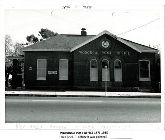
Photograph - Codling Collection 01 - Wodonga Post Office
... was constructed on the corner of Sydney Road (High Street) and South... on the corner of Sydney Road (High Street) and South Street in 1874 ...Miss Olive Codling was a Foundation Member and a Life Member of the Wodonga Historical Society. Many of her photos are held in the Society Collection. The Wodonga Post Office was constructed on the corner of Sydney Road (High Street) and South Street in 1874. It was Wodonga’s second Post Office. The original post office opened on June 1, 1856 near Wodonga Creek. This building was originally built of red brick, although it was later painted over in white. It had an attached residence in South Street and was connected to it by a door. The residence was later demolished to move the mail boxes which had faced High Street, to South Street. The brick Telephone Exchange was constructed in 1946 behind the Post Office but separated from it. It operated as a manual exchange until the late 1960’s or early 1970’s. In 1985 a new post office was opened further south in High Street. This building, greatly renovated, is now part of the Wodonga Community College.This photo collection is significant as it documents how the businesses and buildings in Wodonga have evolved and contributed to community throughout the 20th century. A black and white image of the 2nd Wodonga Post Office. There are 6 windows across the front of the building and the name Wodonga Post Office below a round clock. To the left of the building is the royal insignia of the crown above the letters E.R. A sign for the Commonwealth Saving Bank of Australia is also attached to the wall.high st wodonga, wodonga post office, businesses wodonga -
 Bendigo Historical Society Inc.
Slide - Images by Arthur Pulfer, 1957-1970
... bull street bendigo... Town Hall and Bull Street Bendigo Law Courts and Police Station... Inc. History House 11 Mackenzie Street Bendigo goldfields 1965 ...1965 fire at the Bendigo Railway Station A dull explosion in the refreshment room about 1:30 p.m. touched off the blaze, which quickly spread and burnt out the station in less than an hour. Just before the explosion a train carrying more than 200 Melbourne-bound holiday makers pulled out of the station. Scores of railways employees in other parts of the station did not realise the refreshment room was on fire until a signal box attendant gave the alarm. Early estimates place damage at more than £100,000. Quick work by station staff saved many thousands of pounds worth of equipment before flames engulfed the building from end to end. At the height of the blaze, a Bendigo fire brigade Station Officer, Vin Lapsley, fell 18 feet – and miraculously landed on his feet – after being overcome by smoke while directing a hose from a ladder on to the roof. Mr. Lapsley was later treated for a broken bone in his right leg.Many images from by Arthur Pulfer copied to slides. Nineteen Slides of Bendigo images: Bendigo Railway Station after fire 1965 New Bendigo Railway Station after the fire Bendigo Town Hall and Bull Street Bendigo Law Courts and Police Station from the conservatory gardens Gold Panners Monument with the Bendigo Technical school in the background Bendigo Cenotaph - set up for an event - Charing Cross - 1957 New Bendigo Chinese Dragon 'Loong' 1970 Easter Procession 1957 Golden Square High School September 1965 Hattam Street Bendigo Opening of Golden Oaks retirement village September 1965 - Hattam Street Bendigo High Street Golden Square, Bendigo - monument to the founding of gold in the area Bendigo Showgrounds with the Benevolent Home and the Base Hospital in the background Old Base Hospital Lucan Street Bendigo Arnold Street former shop Bendigo Alexandra Fountain Charing Cross Bendigo Banner - Bendigo Training Centre Bendigo House - address unknownhistory, bendigo, james lerk collection, bendigo conservatory, conservatory gardens bendigo, bendigo town hall, bull street bendigo, bendigo railway station fire, golden square high school, golden oaks village bendigo, dragon loong, bendigo cenotaph, alexandra fountain bendigo, bendigo base hospital, bendigo benevolent home, bendigo easter procession -
 Hume City Civic Collection
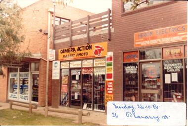
Photograph, 26/10/1980
... o'shanassy street... development which emerged along O'Shanassy Street. These shops were...A coloured photograph of a street scape in O'Shanassy...Hume City Civic Collection 40 Macedon Street Sunbury ...The three brick shops were part of the later commercial development which emerged along O'Shanassy Street. These shops were built on the northern side of Brook Street. Earlier commercial development was confined to the south side of Brook Street.A coloured photograph of a street scape in O'Shanassy Street showing three shop fronts. At the time the photograph was taken the shops were occupied by Kilkenny Real Estate Agent, Camera Action and Heron Electrics. There is a roof top patio area above the camera shop and two treated pine rails are along the nature strip.o'shanassy street, sunbury, kilkenny real estate, camera action, heron electrics, george evans collection -
 Bendigo Historical Society Inc.
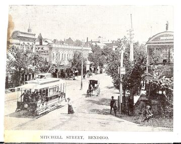
Photograph - BASIL MILLER COLLECTION: ELECTRIC TRAM CLIPPING
... Clipping showing electric tram in Mitchell Street looking... electric tram in Mitchell Street looking from Hargreaves Street ...BHS CollectionClipping showing electric tram in Mitchell Street looking from Hargreaves Street corner towards Charing Cross. J.H. Knight dentist rooms visible on corner of Bath Lane and Mitchell Street, Lazarus Building corner Hargreaves and Mitchell Streets extreme right. Printed underneath image 'Mitchell Street, Bendigo'.unknowncottage, miners -
 St Kilda Historical Society
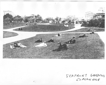
Photograph, Seafront Gardens, Esplanade, 1915-16
... Fitzroy Street and part of Acland Street North, partial view... Carlisle Street St Kilda melbourne Reclaimed from the Sea, Site ...Reclaimed from the Sea, Site of old Bathing Ship, c1915, foreground shows people relaxing on the lawns, background shows Fitzroy Street and part of Acland Street North, partial view of buildings in Fitzroy street, including 1 Fitzroy Streetblack and white photograph, copy, fair conditionSeafront Gardens, Esplanade, Melbourne suburbs St Kilda reclaimed from the sea - sight of the old bathing ship, St Kilda By the Sea Annual, page 59, National Library of Australia, Canberra -
 Stawell Historical Society Inc
Photograph, Cato Lake looking from Viictoria Street -- Coloured
... Cato Lake looking from Viictoria Street -- Coloured...Cato Lake view from Victoria Street looking towards Sloane... Street side looking towards Sloane Street. The lake was emptied... grampians Cato Lake view from Victoria Street looking towards Sloane ...Cato Lake view from Victoria Street looking towards Sloane Street. This view shows the emptying of the lake carried out in c 2002 for deepening the lake by Shire Council Works. This view shows a tractor working around the empty lake. Coloured photograph of emptied Cato Lake from Victoria Street side looking towards Sloane Street. The lake was emptied in c 2002 for deepening by Shire Council Works. This view shows a tractor working around the emptied lake. In the background are trees with houses amounts them.Written in biro 5.2.2002stawell -
 Stawell Historical Society Inc
Photograph, Cato Lake looking from Victoria Street -- Coloured
... Cato Lake looking from Victoria Street -- Coloured... taken from Victoria Street, rear of Napier Street residences.... This view is from Victoria Street, rear of Napier residences.... Photo taken from Victoria Street, rear of Napier Street ...View of Cato Lake showing the excavation of the lake. Photo taken from Victoria Street, rear of Napier Street residences. The excavation of the lake was to increase its depth and a excavator and bulldozer can be seen working the ground. Willow trees are to the right in the photo.Coloured photograph of the deepening of Cato Lake in c 2002. This view is from Victoria Street, rear of Napier residences. In this photo an excavator is removing dirt with a bulldozer in the background. 5.2.2002 (written in biro).stawell -
 Bendigo Historical Society Inc.
Document - MCCOLL, RANKIN AND STANISTREET COLLECTION: WATER RIGHT LICENCE NORTH DEBORAH MINING COMPANY NO LIABILITY, 19th August, 1941
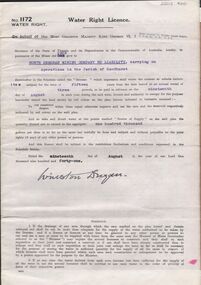
... lease 9988 to dam. Streets marked: Adams Road, Honeybone Street... Inc. History House 11 Mackenzie Street Bendigo goldfields ...4 page document plus map, Water Right Licence No. 1172, between King George VI ( the Crown ) and North Deborah Mining Company No Liability, Parish of Sandhurst., dated 19th August 1941. "to take and divert water at the points marked 'source of supply' on the said plan the quantity thereof not to exceed in the aggregate one hundred thousand gallons per diem' Plan: 'Mining District of Bendigo No. 1172 W.R., County of Bendigo, Parish of Sandhurst. Plan has dam area coloured in red, with pipe line drawn in red, leading from Battery marked on lease 11145 across lease 9988 to dam. Streets marked: Adams Road, Honeybone Street, Griston Street. (Golden Square area)bendigo, mining, north deborah mining company, north deborah mining company, adams, honeybone, and griston streets. (golden square) -
 Eltham District Historical Society Inc
Drawing, Caroline Shillinglaw (1876-1956), c.1896
... Street in April 1882. She married Christopher Watson on 23 Oct... Street in April 1882. She married Christopher Watson on 23 Oct ...Caroline (Carrie) Shillinglaw was the third child of Phillip and Sarah Shillinglaw, born 29 February 1876 in Bundoora. She commenced school at Eltham State School No. 209 in Dalton Street in April 1882. She married Christopher Watson on 23 Oct. 1907. Christopher Watson was son of Christopher Watson Jnr, the owner of Watson's Hotel on the corner of Pitt Street and Maria Street (Main Road).caroline shillinglaw, caroline watson (nee shillinglaw), caroline (carrie) watson (nee shillinglaw 1876-1956), carrie shillinglaw -
 St Kilda Historical Society
Photograph
... Fitzroy Street... of Fitzroy Street and Princes Street St Kilda, was one of the first...167 Fitzroy Street, St Kilda, Victoria ... Carlisle Street St Kilda melbourne The bluestone 1857-58 former ...The bluestone 1857-58 former Wesleyan Church, on the corner of Fitzroy Street and Princes Street St Kilda, was one of the first Wesleyan churches in Victoria designed in the gothic style. It had a square central entrance tower and early English stepped buttresses and pinnacles above. It was later the St Kilda Uniting Church and was closed on 25 June 1978. It has now been covered to flats.According to Heritage Victoria: The old St Kilda Methodist Church is a finely designed 1850's church building and centrepiece of a group of individually significant buildings in an urban conservation area. Towered churches from the 1850s are rare in Melbourne and this building is thus of special significance in this regard as well as for its design and detailing. This building is an important work of architects Crouch & Wilson. Thomas Crouch was prominent in St Kilda Methodist church affairs and lived locally. He served a term as mayor of St Kilda and also designed the chapel at Pentridge and Methodist churches at Fitzroy, Collingwood, Flemington, Daylesford and Maldon. St Kilda was the home of many of the better off Melbournians in the 1850s, '60s and '70s. The adjacent former Sunday School is one of Melbourne's finest and the combination of fine church and hall side by side gives each added significance. https://vhd.heritagecouncil.vic.gov.au/places/1110churches, fitzroy street, st kilda, crouch, st kilda uniting church, st kilda wesleyan methodist church, princes street -
 Rutherglen Historical Society
Images, 1970s
... from Main Street to Reid Street, and much of it is now the car...Rutherglen Historical Society Murray Street Rutherglen high ...One of a collection of photographs from the Iggsten Estate. Woman in photo may be Florence Iggsten. Post Office lane ran from Main Street to Reid Street, and much of it is now the car park for the IGA Supermarket. The Main Street end between the supermarket and the post office is closed to all but pedestrian traffic, and is now called Gollings Square. It is a rest area with trees, garden, sculptures and benches.Colour photograph taken in Post Office Lane, Rutherglen. Roof of the Post Office is visible on the left, and the front of the Victoria Hotel at the end of the road.post office lane, post offices, victoria hotel, florence iggsten, gollings square -
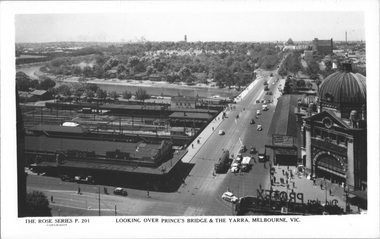 Melbourne Tram Museum
Postcard, Rose Stereograph Co, "Looking over Princes Bridge & The Yarra, Melbourne", c1941
... St station. The south west curve track from Swanston Street... curve track from Swanston Street into Flinders Street is visible ...Rose Series postcard No. P 201, titled "Looking over Princes Bridge & The Yarra, Melbourne" with a view including Princes Bridge Railway Station, Batman Ave. tram terminus with two trams, The Yarra River, the bridge, and the entrance to Flinders St station. The south west curve track from Swanston Street into Flinders Street is visible along with various Safety Zones at the tram stop.Yields information about St Kilda Road, Princes Bridge c1941Postcard - printed real photograph with Rose Stereograph Co. name on the rear. Two copies held.tramways, flinders st station, st kilda road, princes bridge station, princes bridge, yarra river, flinders st, trams -
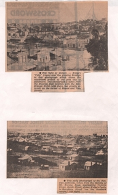 Bendigo Historical Society Inc.
Newspaper - NEWSPAPER CLIPPINGS EARLY PHOTOGRAPHS OF BENDIGO STREETSCAPE, Unknown
... with the Rifle Brigade Hotel on the corner of Rowan and View Streets... Inc. History House 11 Mackenzie Street Bendigo goldfields ...Two Black & White Early Photographs of Bendigo. (Photograph 1) Panorama is taken from the Masonic Hall location with the Rifle Brigade Hotel on the corner of Rowan and View Streets and Knipe's Folly in top right of image. (Photograph 2) An early photograph of the Bendigo Goldfields the suburb of Ironbark taken from the vicinity of Mt. Korong Road, overlooking Victoria Street and Quick Street. Image shows Knipe's Castle in Boundary Street ''on the Ironbark Ranges'' top right.bendigo, streetscape, rowan & view st, mt korong rd -
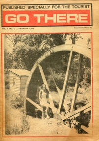 Federation University Historical Collection
Newspaper - Newspaper - Special Publication, Jeff Zilles, ZILLES COLLECTION: Go There, Vol. 1. No.2. February 1974, 1974
... 1930s. It was in McKenzie Street Ballarat. His son Jeffrey also.... It was in McKenzie Street Ballarat. His son Jeffrey also became a printer ...Zilles Printers was begun by Lewis Zilles in the early 1930s. It was in McKenzie Street Ballarat. His son Jeffrey also became a printer - letterpress, offset and screen printer. The business became Zilles Printers/Graphics and was in Armstrong Street and later Bell Street Ballarat.Go There was a newspaper published especially for tourists, and covered Ballarat, Daylesford, Castlemaine, Kyneton, Malmsbury, Trentham, Greendale, Hepburn Springs, Bendigo, Guidlford, Newstead.ballarat, daylesford, castlemaine, kyneton, malmsbury, trentham, greendale, hepburn springs, bendigo, guidlford, newstead, newbury, waterwheel, waterwheel farm, jack smales, val henderson, ken lock, advertisements, castlemaine market building, weerona tropical aquarium, maldon, merlo, newstead pottery, trevor whelan, welshman's reef, newstead butter, eureka swimming pool -
 Federation University Historical Collection
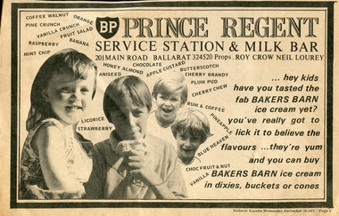
Newspaper - Newspaper - advertisement, Jeff Zilles, ZILLES COLLECTION: Prince Regent Service Station and Milk Bar Advertisement, c1975
... 1930s. It was in McKenzie Street Ballarat. His son Jeffrey also.... It was in McKenzie Street Ballarat. His son Jeffrey also became a printer ...Zilles Printers was begun by Lewis Zilles in the early 1930s. It was in McKenzie Street Ballarat. His son Jeffrey also became a printer - letterpress, offset and screen printer. The business became Zilles Printers/Graphics and was in Armstrong Street and later Bell Street Ballarat.Newspaper advertisement for Prince Regent Service Station and Milk Bar.prince regent service station and milk bar advertisement, main road ballarat east -
 Federation University Historical Collection
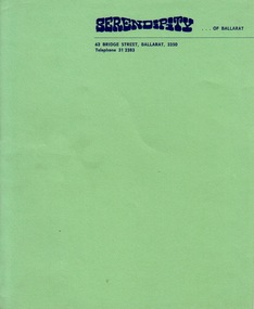
Document - Document - Letterhead, ZILLES COLLECTION: Letterhead for Serendipity of Ballarat
... 1930s. It was in McKenzie Street Ballarat. His son Jeffrey also...Address: 62 Bridge Street Ballarat 3350.... It was in McKenzie Street Ballarat. His son Jeffrey also became a printer ...Zilles Printers was begun by Lewis Zilles in the early 1930s. It was in McKenzie Street Ballarat. His son Jeffrey also became a printer - letterpress, offset and screen printer. The business became Zilles Printers/Graphics and was in Armstrong Street and later Bell Street Ballarat.Bright green textured paper with navy blue printAddress: 62 Bridge Street Ballarat 3350zilles printers, ballarat, serendipity of ballarat -
 Federation University Historical Collection
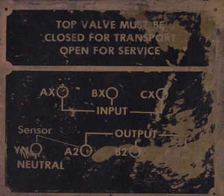
Sign - Sign - Instructions, ZILLES COLLECTION: Metal Plate with instructions: Top Valve
... 1930s. It was in McKenzie Street Ballarat. His son Jeffrey also.... It was in McKenzie Street Ballarat. His son Jeffrey also became a printer ...Zilles Printers was begun by Lewis Zilles in the early 1930s. It was in McKenzie Street Ballarat. His son Jeffrey also became a printer - letterpress, offset and screen printer. The business became Zilles Printers/Graphics and was in Armstrong Street and later Bell Street Ballarat.Gold colour metal plate with black sectionszilles printers -
 Kew Historical Society Inc
Plan, Melbourne & Metropolitan Board of Works : Borough of Kew : Detail Plan No.1590, 1905
... and environmental features. Each plan covers one or two street blocks... includes built structures in Mary Street, Cotham Road, High Street... features. Each plan covers one or two street blocks (roughly six ...The Melbourne and Metropolitan Board of Works (MMBW) plans were produced from the 1890s to the 1950s. They were crucial to the design and development of Melbourne's sewerage and drainage system. The plans, at a scale of 40 feet to 1 inch (1:480), provide a detailed historical record of Melbourne streetscapes and environmental features. Each plan covers one or two street blocks (roughly six streets), showing details of buildings, including garden layouts and ownership boundaries, and features such as laneways, drains, bridges, parks, municipal boundaries and other prominent landmarks as they existed at the time each plan was produced. (Source: State Library of Victoria)This plan forms part of a large group of MMBW plans and maps that was donated to the Society by the Mr Poulter, City Engineer of the City of Kew in 1989. Within this collection, thirty-five hand-coloured plans, backed with linen, are of statewide significance as they include annotations that provide details of construction materials used in buildings in the first decade of the 20th century as well as additional information about land ownership and usage. The copies in the Public Record Office Victoria and the State Library of Victoria are monochrome versions which do not denote building materials so that the maps in this collection are invaluable and unique tools for researchers and heritage consultants. A number of the plans are not held in the collection of the State Library of Victoria so they have the additional attribute of rarity.Original survey plan, issued by the MMBW to a contractor with responsibility for constructing sewers in the area identified on the plan within the Borough of Kew. The plan was at some stage hand-coloured, possibly by the contractor, but more likely by officers working in the Engineering Department of the Borough and later Town, then City of Kew. The hand-coloured sections of buildings on the plan were used to denote masonry or brick constructions (pink), weatherboard constructions (yellow), and public buildings (grey). Surveyed by the Board of Works in 1903 and published in 1904, Plan No.1590 shows development north of Cotham Road. While this plan includes built structures in Mary Street, Cotham Road, High Street, Park Hill Road, Kent Street, Ridgeway Avenue, and Ermington Lane (now Ermington Place), only part of this section was notated and coloured in this contractor’s copy. Numerous houses, large and small are named on the plan: ‘Cholula’, ‘Belper’, ‘The Uplands’, ‘Spring Grove’ facing Cotham Road; ‘Marion’ facing Kent Street; and ‘Kia Ora’ facing Ridgeway Avenue.melbourne and metropolitan board of works, detail plans, mmbw 1590, survey plans - borough of kew, cartography -
 Kew Historical Society Inc
Plan, Melbourne & Metropolitan Board of Works : Borough of Kew : Detail Plan No.1297, 1904
... and environmental features. Each plan covers one or two street blocks... bounded by Barkers Road, High Street and Stevenson Street. Because... features. Each plan covers one or two street blocks (roughly six ...The Melbourne and Metropolitan Board of Works (MMBW) plans were produced from the 1890s to the 1950s. They were crucial to the design and development of Melbourne's sewerage and drainage system. The plans, at a scale of 40 feet to 1 inch (1:480), provide a detailed historical record of Melbourne streetscapes and environmental features. Each plan covers one or two street blocks (roughly six streets), showing details of buildings, including garden layouts and ownership boundaries, and features such as laneways, drains, bridges, parks, municipal boundaries and other prominent landmarks as they existed at the time each plan was produced. (Source: State Library of Victoria)This plan forms part of a large group of MMBW plans and maps that was donated to the Society by the Mr Poulter, City Engineer of the City of Kew in 1989. Within this collection, thirty-five hand-coloured plans, backed with linen, are of statewide significance as they include annotations that provide details of construction materials used in buildings in the first decade of the 20th century as well as additional information about land ownership and usage. The copies in the Public Record Office Victoria and the State Library of Victoria are monochrome versions which do not denote building materials so that the maps in this collection are invaluable and unique tools for researchers and heritage consultants. A number of the plans are not held in the collection of the State Library of Victoria so they have the additional attribute of rarity.Original survey plan, issued by the MMBW to a sewage contractor with responsibility for constructing sewers in the area identified on the plan within the Borough of Kew. The plan was at some stage hand-coloured, possibly by the contractor, but more likely by officers working in the Engineering Department of the Borough and later Town, then City of Kew. The hand-coloured sections of buildings on the plan were used to denote masonry or brick constructions (pink), weatherboard constructions (yellow), and public buildings (grey). This plan of Kew encompasses the area bounded by Barkers Road, High Street and Stevenson Street. Because of the angle created by High Street, a number of houses on the northern side of High Street are shown. The area is dominated by one of the great original landholdings in Kew, described here as the ‘Findon Paddock’. ‘Findon’, the house from which the name of the paddock was taken fronts Stevenson Street and was clearly a rambling structure. The best-known occupant of Findon was Henry ‘Money Miller’ who bought the house in 1871. Miller was a member of Victoria’s first parliament and assisted in the framing of its constitution. Findon was to be subdivided as early as 1912, when the Findon Subdivision was advertised to be sold by auction. In the plan of the subdivision, the original house is not shown, so, presumably it had previously been demolished. Fincham & Son moved the organ, built by Henry Willis, which was installed in the house, first to ‘Whernside’ in Toorak, and later to the Box Hill Methodist Church.melbourne and metropolitan board of works, detail plans, mmbw 1297, cartography, kew (vic.) — municipal collection -
 Whitehorse Historical Society Inc.
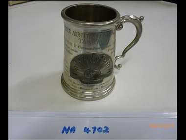
Memorabilia - Army Tankard
... the Returned Services League, Mitcham Sub-Branch, 26 McDowall Street... McDowall Street, Mitcham, cnr Harrison Street when it closed early ...Tankard to commemorate conflicts in which the Australian Army has been involved since and including World War I. From the Returned Services League, Mitcham Sub-Branch, 26 McDowall Street, Mitcham, cnr Harrison Street when it closed early 2014.Australian Army Tankard with Australian rising sun badge on front. Tankard is made of pewter with a glass base. On the tankard all the conflicts that the Australian fought in are commemorated from World War I to Vietnam.The Australian Army Tankard, World War I, World War I, Mesopotamia, Flanders, German New Guinea, Gallipoli, France, Palestine, World War II, North Africa, Crete, Malaya, S.W. Pacific, Timor, New Guinea, Java, Bougainville, Borneo, Greece, Syria, Singapore, South Africa, Korea, Malaya, Vietnam.military history, army, metalcraft, pewterware -
![Victorian era cottage, Derby Street [Kew]](/media/collectors/550653872162f11fb04854aa/items/658f5772101c4283c6ae47ff/item-media/658f57e4101c4283c6ae493a/item-fit-380x285.jpg) Kew Historical Society Inc
Kew Historical Society IncPhotograph - Victorian era cottage, Derby Street [Kew], c. 1965
... Victorian era cottage, Derby Street [Kew]...derby street (Kew)... Street Kew previously housed the Kew Depot on the corner...Small single fronted cottage in Derby Street, Kew... The current site of the Kew Recreation Centre in High Street Kew ...The current site of the Kew Recreation Centre in High Street Kew previously housed the Kew Depot on the corner of Disraeli Street. In nearby Derby Street, a number of original Victorian era buildings were gradually replaced due to development of the Baths precinct and commercial development.This work forms part of the collection assembled by the historian Dorothy Rogers (1905-1973), donated to the Kew Historical Society by her son in 2015. The manuscripts, photographs, maps, and documents were sourced by her from both family and local collections or produced as references for her print publications. Many were directly used by Rogers in writing ‘Lovely Old Homes of Kew’ (1961) and 'A History of Kew' (1973), or the numerous articles on local history that she produced for suburban newspapers. Most of the photographs in the collection include detailed annotations in her hand. The Rogers Collection provides a comprehensive insight into the working habits of a historian from the 1960s to the 1970s. Small single fronted cottage in Derby Street, Kew. The weatherboard cottage has a block fronted facade, and a Victorian verandah with cast iron lace.Annotation verso: "House in Derby St., next to Kew Baths (Demolished?)"dorothy rogers, derby street (kew), victorian houses -- kew (vic.)