Showing 570 items
matching boundary road
-
 Monbulk Historical Society
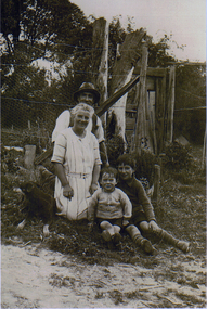
Thomas and Lillian Cavey with sons Tom and George
Thomas William Cavey was born in 1871, he was the youngest of his family and the only child that was born in Australia. He was first employed at the lime kilns in Geelong, before moving to Queensland for 4 years where he worked as a Boundary Rider. Thomas returned to the Lilydale area to be the driver of a buggy and pair for David Mitchell of David Mitchell Quarry in Lilydale. He selected land in Seamer Road in Monbulk in about 1898, but was working for the railways in Melbourne at the time and would come up to Monbulk at weekends to clear and cultivate the land. He met Lillian Eager, probably through relatives of hers, the Wingates, who lived in Monbulk. He and LIllian were married in 1910. They bought a 22 acre property in what is now called Cavey Road. They had two sons Thomas Charles, born in 1918 and George William Born in 1923. Initially the property in Cavey Road was farmed for vegetables, fruit and berries. The land used for this was over a creek on steep land away from the house. Once the produce was harvested it was taken by flying fox, back across the creek to where it could be prepared for sale. It was then taken to the Emerald and Belgrave markets each week. Later 10 cows were purchased, and the main income from the property was the dairy which produced approximately 25 quarts of milk a day, they produced Cream and Butter and together with the milk they were delivered fresh daily in the horse and cart. Deliveries were made to Monbulk, The Patch and to the canvas town at Silvan Dam, where the workers building the Silvan Dam lived. Thomas William Cavey died in 1959 aged 89. Lillian Blanche Cavey died in 1949 aged 68. -
 Ballarat and District Irish Association
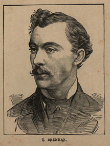
Image, T. Brennan, c1864, 1864
Following the founding meeting of the Mayo Tenants Defence Association in Castlebar, County Mayo on 26 October 1878 the demand for The Land of Ireland for the people of Ireland was reported in the Connaught Telegraph 2 November 1878. The first of many "monster meetings" of tenant farmers was held in Irishtown near Claremorris on 20 April 1879, with an estimated turnout of 15,000 to 20,000 people. This meeting was addressed by James Daly (who presided), John O'Connor Power, John Ferguson, Thomas Brennan, and J. J. Louden. The Connaught Telegraph's report of the meeting in its edition of 26 April 1879 began: Since the days of O'Connell a larger public demonstration has not been witnessed than that of Sunday last. About 1 o'clock the monster procession started from Claremorris, headed by several thousand men on foot – the men of each district wearing a laural leaf or green ribbon in hat or coat to distinguish the several contingents. At 11 o'clock a monster contingent of tenant-farmers on horseback drew up in front of Hughes's hotel, showing discipline and order that a cavalry regiment might feel proud of. They were led on in sections, each having a marshal who kept his troops well in hand. Messrs. P.W. Nally, J.W. Nally, H. French, and M. Griffin, wearing green and gold sashes, led on their different sections, who rode two deep, occupying, at least, over an Irish mile of the road. Next followed a train of carriages, brakes, cares, etc. led on by Mr. Martin Hughes, the spirited hotel proprietor, driving a pair of rare black ponies to a phæton, taking Messrs. J.J. Louden and J. Daly. Next came Messrs. O'Connor, J. Ferguson, and Thomas Brennan in a covered carriage, followed by at least 500 vehicles from the neighbouring towns. On passing through Ballindine the sight was truly imposing, the endless train directing its course to Irishtown – a neat little hamlet on the boundaries of Mayo, Roscommon, and Galway. Evolving out of this a number of local land league organisations were set up to work against the excessive rents being demanded by landlords all over Ireland, but especially in Mayo and surrounding counties. From 1874 agricultural prices in Europe had dropped, followed by some bad harvests due to wet weather during the Long Depression. The effect by 1878 was that many Irish farmers were unable to pay the rents that they had agreed, particularly in the poorer and wetter parts of Connacht. The localised 1879 Famine added to the misery. Unlike other parts of Europe the Irish land tenure system was inflexible in times of hardship. (Wikipedia) The Irish National Land League was founded at the Imperial Hotel in Castlebar, the County town of Mayo, on 21 October 1879. At that meeting Charles Stewart Parnell was elected president of the league. Andrew Kettle, Michael Davitt, and Thomas Brennan were appointed as honorary secretaries. This united practically all the different strands of land agitation and tenant rights movements under a single organisation. Michael Davitt Founder of the Land League The two aims of the Land League, as stated in the resolutions adopted in the meeting, were: ...first, to bring out a reduction of rack-rents; second, to facilitate the obtaining of the ownership of the soil by the occupiers. That the object of the League can be best attained by promoting organisation among the tenant-farmers; by defending those who may be threatened with eviction for refusing to pay unjust rents; by facilitating the working of the Bright clauses of the Irish Land Act during the winter; and by obtaining such reforms in the laws relating to land as will enable every tenant to become owner of his holding by paying a fair rent for a limited number of years. (Wikipedia)Image of a man with a moustache. He is T. Brennan.ballarat irish, brennan, thomas brennan, irish land act, rent -
 Peterborough History Group
Newspaper articles pertaining to Peterborough from 1990 to 1999
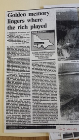
Various newspaper articles kept by Mrs Dawn Irvine, all pertaining to Peterborough - river flooding and quality, concerns over council boundary realignment. Article titles: 6/10/1992 Flooding at Peterborough 28/6/1994 Residents undecided over River 4/7/1994 Letter from Warren Moore. Peterborough is alive, the way residents like it. 26/12/1994 Letter from R. Irvine. Apprehension over changes 17/6/1998 Algae fear prompts call to open Curdies River 13/4/1999 Battlelines on the Curdies 14/4/1999 Peterborough residents urge BHP to find alternative waste disposal optionHistoric overview of the towns' concerns at that time. Seven newspaper cuttings of various sizes all regarding aspects of Peterborough. Includes objection to BHP discharging waste into the Curdies River and flooding. warren moore, ronald irvine, curdies river, moyne council, council boundary realignment, curdies river flooding, floods, peterborough, blue green algae, river quality, bhp waste management, bhp -
 Peterborough History Group
Document - Maps, tourist information
Council boundaries, past tourist information, past mapsHistoric town information and mapsPhotocopies, copies of maps, newspaper clippingpeterborough history, peterborough 3270 -
 Peterborough History Group
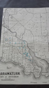
Map - Map of Curdies River Inlet district, Narrawaturk
Shows the allotment boundaries and names of landowners at the timeSignificant as it shows owners of rural land in the Peterborough area.Photocopy of an old mapHandwritten notes and markings on the map.peterborough, curdies river, curdies river inlet, old maps, maps, narrawaturk -
 Peterborough History Group
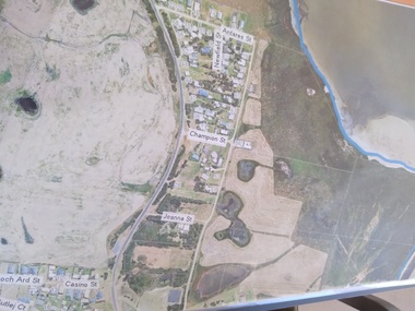
Plan - Moyne Shire Council Aerial photograph, Department of Sustainability and Environment, January 2018
View shows development at the time and showing the town boundary using Vicmap InformationSignificant in that it provides a record of the current state of development of the town. Also, a view of the estuary at that time.A3 size copy of an aerial view of the majority of the town with street names mentioned. curdies river inlet, peterborough, aerial view -
 Peterborough History Group
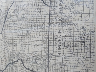
Map - Shire of Warrnambool
Map of the area, when Peterborough was part of Warrnambool ShireHistoric map of the area when Peterborough was in the Warrnambool ShireA3 size map, larger view of the whole shire of Warrnambool, and includes adjoining Shire Boundaries. Shows individual land allotments.peterborough, warrnambool shire, old maps -
 Hume City Civic Collection
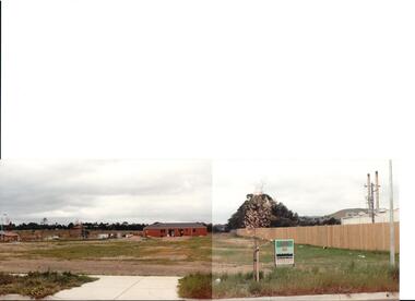
Photograph, early 1990s
The series of 5 photographs feature different views of the Woodlands housing development which opened up land bounded by Gap and Anderson Roads, Cornish Street and Elizabeth Drive in the early 1990s. It was a large housing development built close to Sunbury township.A view of the northern boundary of the Woodlands housing development in Anderson Road. A paling fence divides the estate from the 'Malley' factory, now 'Storage King' which is on the corner of Cornish Street and Anderson Road. A 'For Sale' sign is in the foreground and a partly built house is in the middle distance.housing developments, anderson road, george evans collection -
 Kew Historical Society Inc
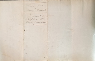
Legal record (Item), Thomas Judd to James Bonwick: Agreement for Sale of Land at Parish of Boroondara, 1853, 28/02/1853
... to the Government Road being the Southern Boundary of Portion Eighty five... to the Government Road being the Southern Boundary of Portion Eighty five ...James Bonwick (1817-1906), the Victorian educator and historian, acquired land in Kew on which to establish a home and school in 1853, not 1854 as more commonly stated. Bonwick returned to England in 1859 for a period, later returning to Melbourne and settling in St Kilda. He was the author of a number of histories and an official transcriber of Government records.This newly acquired document, from a former owner of 'Parkhill' (20 Hillcrest Avenue, Kew), is of statewide importance as it is the original copy of the agreement made between Thomas Judd of Parkhill and James Bonwick in 1853 for the purchase of land in Kew. Both Thomas Judd and James Bonwick were significant pioneers of Victoria.TRANSCRIPT [TITLE] Thomas Judd to James Bonwick Agreement for Sale of Land at Parish of Boroondara [PAGE 1] Articles of agreement made and entered into this the Twentyth eighth day of February One thousand Eight Hundred and fifty three Between Thomas Judd of Melbourne in the Colony of Victoria Gentleman of the one part and James Bonwick of Melbourne in the Colony of Victoria Gentleman of the other part whereby the said Thomas Judd agrees to sell unto the said James Bonwick who hereby agrees to purchase a piece or parcel of land containing two and half acres be the land more or less part of Portion Number Eighty five of the Parish of Boroondara in the County of Bourke commencing at a point on the Northern boundary line of the said Portion Seventeen Chains fifty links East from the North West angle of the same and bounded on the East by other part of said Portion in a line bearing South Eight Hundred and sixty two feet on the South by other part of said Portion Eighty five in a line bearing West one Hundred twenty six and half feet on the West by other part of said Portion Eighty five in a line bearing North Eight Hundred and Sixty two feet on the North by the Northern boundary line of the said Portion Eighty five in a line bearing East one Hundred twenty six and half feet to the commencing point at or for the price or sum of one [PAGE 2] One Hundred Pounds to be paid and payable in the manner hereinafter mentioned that is to say the Sum of Thirty pounds to be paid on the day of the date hereof and the sum of forty pounds by the acceptance of the said James Bonwick for that sum at three months bearing interest thereon after the rate of Eight Pounds per centum per annum and the Sum of Thirty pounds by the acceptance of the said James Bonwick for that sum after Six months with interest thereon after the rate of Eight pounds per centum per annum It is furthermore agreed that the said James Bonwick shall have access by a right of way fifteen feet wide reserved by the said Thomas Judd to the Government Road being the Southern Boundary of Portion Eighty five. That in case default shall be made in the payment of any of any of the Acceptances above mentioned the amount paid shall be actually forfeited to the said Thomas Judd who shall be at liberty to resell the premises. That upon payment of the whole amount of the purchase money the said Thomas Judd shall execute a conveyance of the premises to the said James Bonwick Such conveyance to be prepared by and at the expense of the said James Bonwick who - [PAGE 3] who shall also pay the cost of any attested copies he may require. ---- As witness the hands of the said parties this the twenty first day of February one thousand Eight Hundred and fifty Three. ----- [Signature] T. Judd [Signature] Jas Bonwick Witness [Signature illegible] £ Received Cash on account of the above 30.0.0 Thirty Pounds Bill at three Months with interest 42.4.0 Bill at Six Months with interest 31.4.0 _____ £103.8.0 _____ [Signature] T. Judd [Signature] Jas Bonwick ------------ Transcribed David White 25/08/2020 james bonwick, thomas judd, land titles - kew (vic), pioneers - kew - victoria -
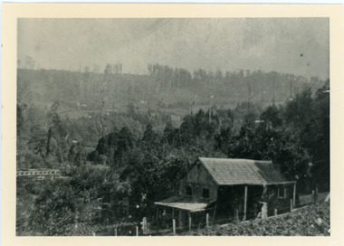 Mt Dandenong & District Historical Society Inc.
Photograph, Harry Child's Hut, early 1900s
Home of Harry Child in foreground built on the southern boundary of his father's (Francis Matthew Child) allotment. Black and white photograph showing the home of Harry Child. This photograph has a detailed inscription on the back handwritten by John Lundy-Clarke.The eastern face of Mt Dandenong from F.M. Childs selection Cnr allotment D.francis matthew child, mt dandenong, harry child -
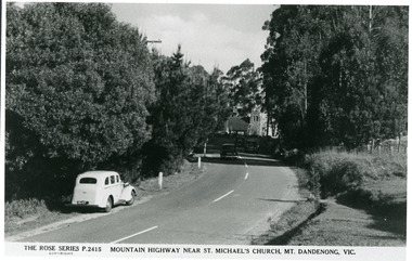 Mt Dandenong & District Historical Society Inc.
Photograph, Mountain Highway Near St. Michael's Church, Mt. Dandenong, Vic, c1950
... as the Mountain Highway was the Sassafras - Basin Road though it may... at Mt. Dandenong / Kalorama as Falls Road is the boundary. Note ...Rose Series Postcard number 2415Copy of Rose Series post card taken c1950. St. Michael's Foundation Stone laid in 1940. Name 'Mountain Highway" is incorrect as the Mountain Highway was the Sassafras - Basin Road though it may not have received that name by 1950. The correct name is the Mount Dandenong Tourist Road at Mt. Dandenong / Kalorama as Falls Road is the boundary. Note: Heavy roadside vegetation, no white lines at side of road. White car probably pre war Vauxhall.kalorama, mount dandenong, rose series, st. michael's church, mt. dandenong tourist road -
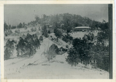 Mt Dandenong & District Historical Society Inc.
Photograph, Kalorama Gap Under Snow 1921, 1921
View of Kalorama Gap under snow taken in 1921. Mountjoy Guest House is at top right and Beulah Tea Rooms is in the centre. This photograph has a detailed inscription on the back handwritten by John Lundy-Clarke in 1974.Kalorama Gap under snow 1921 The leafless elm trees are low in the centre and the dual nature of the nearer one can be clearly seen, two small suckers of the older farther tree being twisted together in 1898 by Fred Jeeves. The older tree was planted 1880. Mrs Hands shop can be clearly seen, which was the Mount Dandenong North Post Office. The old Main Road runs up the centre of the picture and turns to the right and disappears behind “Mountjoy” the big guest house built by Paynters in 1905 and sold to Ellis Jeeves 1908, whose family ran it till 1943. At the bend of the road behind the big pine tree and the dark blackwood can be seen faintly the gable of Price’s house that contained the first shop on the mount. Above it is H Walker’s cottage on Ridge Road that still exists, his homestead is on the left of the picture on the same level. Below this house and to the left can be seen Ted Prices hay and corn store. The present estate agency lies between these two buildings, on the road which had recently been built. This can be seen winding from the lower left corner of picture to the left of the elms. The CRB had recently fenced the road and this is clearly seen as it circles behind trees in the left centre. Barber’s Road crosses CRB Road to the left of the dray under the leafless elm and the Coach Road dives down to the right just behind the pair of blackwoods to right of the elms. The picture was taken from just above the boundary of Isaac Jeeves’s selection Crown Allotment “C” (Jeeves Saddle) which stretched across the Gap to the other side of Mrs Hand’s shop, monopolising the gap from 1871 to 1879. Price’s house remains partly as the small house – “Mirra Laken”. kalorama gap, fiveways, post office, mountjoy, guest house, snow -
 Kew Historical Society Inc
Plan, Melbourne & Metropolitan Board of Works : Borough of Kew : Detail Plan No.1296, 1904
The Melbourne and Metropolitan Board of Works (MMBW) plans were produced from the 1890s to the 1950s. They were crucial to the design and development of Melbourne's sewerage and drainage system. The plans, at a scale of 40 feet to 1 inch (1:480), provide a detailed historical record of Melbourne streetscapes and environmental features. Each plan covers one or two street blocks (roughly six streets), showing details of buildings, including garden layouts and ownership boundaries, and features such as laneways, drains, bridges, parks, municipal boundaries and other prominent landmarks as they existed at the time each plan was produced. (Source: State Library of Victoria)This plan forms part of a large group of MMBW plans and maps that was donated to the Society by the Mr Poulter, City Engineer of the City of Kew in 1989. Within this collection, thirty-five hand-coloured plans, backed with linen, are of statewide significance as they include annotations that provide details of construction materials used in buildings in the first decade of the 20th century as well as additional information about land ownership and usage. The copies in the Public Record Office Victoria and the State Library of Victoria are monochrome versions which do not denote building materials so that the maps in this collection are invaluable and unique tools for researchers and heritage consultants. A number of the plans are not held in the collection of the State Library of Victoria so they have the additional attribute of rarity.Original survey plan, issued by the MMBW to a contractor with responsibility for constructing sewers in the area identified on the plan within the Borough of Kew. The plan was at some stage hand-coloured, possibly by the contractor, but more likely by officers working in the Engineering Department of the Borough and later Town, then City of Kew. The hand-coloured sections of buildings on the plan were used to denote masonry or brick constructions (pink), weatherboard constructions (yellow), and public buildings (grey). This area was once known as O’Shaughnessy’s Paddock. O’Shaughnessy was the licensee of the Kew Hotel. The ‘Paddock’ or farm was for many years the closest farm to Melbourne. By 1903, when this plan was surveyed and lithographed, little of the farm remained. The area is dominated by a ‘clay hole’, on the site of the current Foley Reserve. It was used by Smart’s Brickyard from the 1880s until 1911, when the Council purchased it for a rubbish dump. It is notable as the site is one of the few industrial operations to have existed in Kew. By 1903, urban development was characterised by larger houses fronting Barkers Road and brick and weatherboard villas in Foley Street. Nearer the pit, weatherboard houses predominated. Foley Street bisected the triangular block and continued right to Denmark Street. At this stage, a house impeded the through road, only allowing access via a right of way to High Street.melbourne and metropolitan board of works, detail plans, mmbw 1296, cartography -
 Kew Historical Society Inc
Plan, Melbourne & Metropolitan Board of Works : Borough of Kew : Detail Plan No.1571, 1904
The Melbourne and Metropolitan Board of Works (MMBW) plans were produced from the 1890s to the 1950s. They were crucial to the design and development of Melbourne's sewerage and drainage system. The plans, at a scale of 40 feet to 1 inch (1:480), provide a detailed historical record of Melbourne streetscapes and environmental features. Each plan covers one or two street blocks (roughly six streets), showing details of buildings, including garden layouts and ownership boundaries, and features such as laneways, drains, bridges, parks, municipal boundaries and other prominent landmarks as they existed at the time each plan was produced. (Source: State Library of Victoria)This plan forms part of a large group of MMBW plans and maps that was donated to the Society by the Mr Poulter, City Engineer of the City of Kew in 1989. Within this collection, thirty-five hand-coloured plans, backed with linen, are of statewide significance as they include annotations that provide details of construction materials used in buildings in the first decade of the 20th century as well as additional information about land ownership and usage. The copies in the Public Record Office Victoria and the State Library of Victoria are monochrome versions which do not denote building materials so that the maps in this collection are invaluable and unique tools for researchers and heritage consultants. A number of the plans are not held in the collection of the State Library of Victoria so they have the additional attribute of rarity.Digital copy of the original survey plan, issued by the MMBW to a contractor with responsibility for constructing sewers in the area identified on the plan within the Borough of Kew. The plan was at some stage hand-coloured, possibly by the contractor, but more likely by officers working in the Engineering Department of the Borough and later Town, then City of Kew. The hand-coloured sections of buildings on the plan were used to denote masonry or brick constructions (pink), weatherboard constructions (yellow), and public buildings (grey). This plan is part of a large and historically significant group of MMBW plans and maps that was donated to the Society by the Mr Poulter, City Engineer of the City of Kew in 1989. When the contracts were let for surveyors to identify and record the extant houses and landscapes within an area for the Board of Works, the contracts were let at separate times, hence the anomaly where two copies of Plan No.1571 exist in our collection. The first of these plans identifies the building materials used in houses bordering Fitzwilliam Street, Edgevale Road, May Street, Malin Street, Davis Street and Wellington Street. The cut off point for the survey was the south side of Wellington Street. By 1903 when the survey was undertaken many of the sites were already built on, particularly those facing Edgevale Road. The plan identifies the preponderance of weatherboard houses in the area. The other version of the plan identifies the buildings between Wellington Street and Cotham Road.melbourne and metropolitan board of works, detail plans, mmbw 1571, cartography -
 Kew Historical Society Inc
Plan, Melbourne & Metropolitan Board of Works : Borough of Kew : Detail Plan No.1571, 1904
The Melbourne and Metropolitan Board of Works (MMBW) plans were produced from the 1890s to the 1950s. They were crucial to the design and development of Melbourne's sewerage and drainage system. The plans, at a scale of 40 feet to 1 inch (1:480), provide a detailed historical record of Melbourne streetscapes and environmental features. Each plan covers one or two street blocks (roughly six streets), showing details of buildings, including garden layouts and ownership boundaries, and features such as laneways, drains, bridges, parks, municipal boundaries and other prominent landmarks as they existed at the time each plan was produced. (Source: State Library of Victoria)This plan forms part of a large group of MMBW plans and maps that was donated to the Society by the Mr Poulter, City Engineer of the City of Kew in 1989. Within this collection, thirty-five hand-coloured plans, backed with linen, are of statewide significance as they include annotations that provide details of construction materials used in buildings in the first decade of the 20th century as well as additional information about land ownership and usage. The copies in the Public Record Office Victoria and the State Library of Victoria are monochrome versions which do not denote building materials so that the maps in this collection are invaluable and unique tools for researchers and heritage consultants. A number of the plans are not held in the collection of the State Library of Victoria so they have the additional attribute of rarity.Original survey plan, issued by the MMBW to a contractor with responsibility for constructing sewers in the area identified on the plan within the Borough of Kew. The plan was at some stage hand-coloured, possibly by the contractor, but more likely by officers working in the Engineering Department of the Borough and later Town, then City of Kew. The hand-coloured sections of buildings on the plan were used to denote masonry or brick constructions (pink), weatherboard constructions (yellow), and public buildings (grey). This plan is the other half of Plan No.1571 representing the constructions to the west of Wellington Street before and in 1903/4. This plan represents the built environment in Edgevale Road, Wellington Street, Atkins Street, Annadale Street, Mortimer Street, and Cotham Road. Whereas there are smaller allotments and more modest housing stock facing Edgevale Road, larger blocks and more substantial houses are represented facing Cotham Road.melbourne and metropolitan board of works, detail plans, mmbw 1571, cartography -
 Kew Historical Society Inc
Plan, Melbourne & Metropolitan Board of Works : Borough of Kew : Detail Plan No.1572, 1905
The Melbourne and Metropolitan Board of Works (MMBW) plans were produced from the 1890s to the 1950s. They were crucial to the design and development of Melbourne's sewerage and drainage system. The plans, at a scale of 40 feet to 1 inch (1:480), provide a detailed historical record of Melbourne streetscapes and environmental features. Each plan covers one or two street blocks (roughly six streets), showing details of buildings, including garden layouts and ownership boundaries, and features such as laneways, drains, bridges, parks, municipal boundaries and other prominent landmarks as they existed at the time each plan was produced. (Source: State Library of Victoria)This plan forms part of a large group of MMBW plans and maps that was donated to the Society by the Mr Poulter, City Engineer of the City of Kew in 1989. Within this collection, thirty-five hand-coloured plans, backed with linen, are of statewide significance as they include annotations that provide details of construction materials used in buildings in the first decade of the 20th century as well as additional information about land ownership and usage. The copies in the Public Record Office Victoria and the State Library of Victoria are monochrome versions which do not denote building materials so that the maps in this collection are invaluable and unique tools for researchers and heritage consultants. A number of the plans are not held in the collection of the State Library of Victoria so they have the additional attribute of rarity.Original survey plan, issued by the MMBW to a contractor with responsibility for constructing sewers in the area identified on the plan within the Borough of Kew. The plan was at some stage hand-coloured, possibly by the contractor, but more likely by officers working in the Engineering Department of the Borough and later Town, then City of Kew. The hand-coloured sections of buildings on the plan were used to denote masonry or brick constructions (pink), weatherboard constructions (yellow), and public buildings (grey). Plan No. 1572 represents the built environment bordered by Barkers Road, Wrixon Street, Edgevale Road and Fitzwilliam Street. Other streets identified on the plan include Stansell Street. Plan 1572 shows that by 1903-05, there was only patchy development in this area of Kew, mainly on Edgevale Road and Fitzwilliam Street. Only two named houses are identified: the quaintly named ‘Tweed Cottage’, and ‘Mendip’. The earliest reference to Treed Cottage in Australian newspapers is to the death of Walter Thompson, aged 74 who was a resident there in 1885. His youngest daughter was to die there in 1908. Mendip to the north of Tweed Cottage was owned by Henry Thompson; he was to die in 1901; his wife in 1932. At this period of time, Malin Street and Clivedon Court did not extend to Barkers Road.melbourne and metropolitan board of works, detail plans, mmbw 1572, cartography -
 Kew Historical Society Inc
Plan, Melbourne & Metropolitan Board of Works : Borough of Kew : Detail Plan No.1573, 1905
The Melbourne and Metropolitan Board of Works (MMBW) plans were produced from the 1890s to the 1950s. They were crucial to the design and development of Melbourne's sewerage and drainage system. The plans, at a scale of 40 feet to 1 inch (1:480), provide a detailed historical record of Melbourne streetscapes and environmental features. Each plan covers one or two street blocks (roughly six streets), showing details of buildings, including garden layouts and ownership boundaries, and features such as laneways, drains, bridges, parks, municipal boundaries and other prominent landmarks as they existed at the time each plan was produced. (Source: State Library of Victoria)This plan forms part of a large group of MMBW plans and maps that was donated to the Society by the Mr Poulter, City Engineer of the City of Kew in 1989. Within this collection, thirty-five hand-coloured plans, backed with linen, are of statewide significance as they include annotations that provide details of construction materials used in buildings in the first decade of the 20th century as well as additional information about land ownership and usage. The copies in the Public Record Office Victoria and the State Library of Victoria are monochrome versions which do not denote building materials so that the maps in this collection are invaluable and unique tools for researchers and heritage consultants. A number of the plans are not held in the collection of the State Library of Victoria so they have the additional attribute of rarity.Original survey plan, issued by the MMBW to a contractor with responsibility for constructing sewers in the area identified on the plan within the Borough of Kew. The plan was at some stage hand-coloured, possibly by the contractor, but more likely by officers working in the Engineering Department of the Borough and later Town, then City of Kew. The hand-coloured sections of buildings on the plan were used to denote masonry or brick constructions (pink), weatherboard constructions (yellow), and public buildings (grey). This plan has detailed annotations written in red or blue ink, showing prices, which may be the annual valuations of the properties, and some owners’ names, a most unusual feature on contractor's maps. Some areas, such as the buildings of Methodist Ladies’ College (MLC), include the school’s tennis court and swimming pool, but are not coloured to show building materials – did the draftsman just run out of time, or ink, or enthusiasm, before his plan had to be submitted? MLC had been founded in 1882 as a ‘modern school of the first order’ with buildings that formed ‘a collegiate institution for girls unsurpassed in the colonies’. The goal of its founders was to provide a high-class Christian education for girls, comparable with that provided elsewhere for boys. Some shops are shown along Edgevale Road, though they are not designated as commercial premises. Larger houses are depicted, including ‘Fairlawn’ in Barkers Road, and ‘Clevedon’ and ‘Rosehill’ (now demolished) in Fitzwilliam Street.melbourne and metropolitan board of works, detail plans, mmbw 1573, maps - borough of kew, cartography -
 Kew Historical Society Inc
Plan, Melbourne & Metropolitan Board of Works : Borough of Kew : Detail Plan No.1575, 1905
The Melbourne and Metropolitan Board of Works (MMBW) plans were produced from the 1890s to the 1950s. They were crucial to the design and development of Melbourne's sewerage and drainage system. The plans, at a scale of 40 feet to 1 inch (1:480), provide a detailed historical record of Melbourne streetscapes and environmental features. Each plan covers one or two street blocks (roughly six streets), showing details of buildings, including garden layouts and ownership boundaries, and features such as laneways, drains, bridges, parks, municipal boundaries and other prominent landmarks as they existed at the time each plan was produced. (Source: State Library of Victoria)This plan forms part of a large group of MMBW plans and maps that was donated to the Society by the Mr Poulter, City Engineer of the City of Kew in 1989. Within this collection, thirty-five hand-coloured plans, backed with linen, are of statewide significance as they include annotations that provide details of construction materials used in buildings in the first decade of the 20th century as well as additional information about land ownership and usage. The copies in the Public Record Office Victoria and the State Library of Victoria are monochrome versions which do not denote building materials so that the maps in this collection are invaluable and unique tools for researchers and heritage consultants. A number of the plans are not held in the collection of the State Library of Victoria so they have the additional attribute of rarity.Original survey plan, issued by the MMBW to a contractor with responsibility for constructing sewers in the area identified on the plan within the Borough of Kew. The plan was at some stage hand-coloured, possibly by the contractor, but more likely by officers working in the Engineering Department of the Borough and later Town, then City of Kew. The hand-coloured sections of buildings on the plan were used to denote masonry or brick constructions (pink), weatherboard constructions (yellow), and public buildings (grey). Plan No.1575 shows that in the area bounded by Wellington Street, Edgevale Road, Glenferrie Road, and Cotham Road, there had already been significant subdivision of land and houses constructed. As one of the highest points in Kew, as expected, there were already some significant mansions built on large allotments of land. Many of these mansions are identified by name on the plan such as ‘Kelso’, ‘Abbotsford’, ‘Clarendon’ and ‘Ashlyn’ in Cotham Road. Other houses of equal size are unnamed on the plan.melbourne and metropolitan board of works, detail plans, maps - borough of kew, mmbw 1575, cartography -
 Kew Historical Society Inc
Plan, Melbourne & Metropolitan Board of Works : Borough of Kew : Detail Plan No.1590, 1905
The Melbourne and Metropolitan Board of Works (MMBW) plans were produced from the 1890s to the 1950s. They were crucial to the design and development of Melbourne's sewerage and drainage system. The plans, at a scale of 40 feet to 1 inch (1:480), provide a detailed historical record of Melbourne streetscapes and environmental features. Each plan covers one or two street blocks (roughly six streets), showing details of buildings, including garden layouts and ownership boundaries, and features such as laneways, drains, bridges, parks, municipal boundaries and other prominent landmarks as they existed at the time each plan was produced. (Source: State Library of Victoria)This plan forms part of a large group of MMBW plans and maps that was donated to the Society by the Mr Poulter, City Engineer of the City of Kew in 1989. Within this collection, thirty-five hand-coloured plans, backed with linen, are of statewide significance as they include annotations that provide details of construction materials used in buildings in the first decade of the 20th century as well as additional information about land ownership and usage. The copies in the Public Record Office Victoria and the State Library of Victoria are monochrome versions which do not denote building materials so that the maps in this collection are invaluable and unique tools for researchers and heritage consultants. A number of the plans are not held in the collection of the State Library of Victoria so they have the additional attribute of rarity.Original survey plan, issued by the MMBW to a contractor with responsibility for constructing sewers in the area identified on the plan within the Borough of Kew. The plan was at some stage hand-coloured, possibly by the contractor, but more likely by officers working in the Engineering Department of the Borough and later Town, then City of Kew. The hand-coloured sections of buildings on the plan were used to denote masonry or brick constructions (pink), weatherboard constructions (yellow), and public buildings (grey). Surveyed by the Board of Works in 1903 and published in 1904, Plan No.1590 shows development north of Cotham Road. While this plan includes built structures in Mary Street, Cotham Road, High Street, Park Hill Road, Kent Street, Ridgeway Avenue, and Ermington Lane (now Ermington Place), only part of this section was notated and coloured in this contractor’s copy. Numerous houses, large and small are named on the plan: ‘Cholula’, ‘Belper’, ‘The Uplands’, ‘Spring Grove’ facing Cotham Road; ‘Marion’ facing Kent Street; and ‘Kia Ora’ facing Ridgeway Avenue.melbourne and metropolitan board of works, detail plans, mmbw 1590, survey plans - borough of kew, cartography -
 Kew Historical Society Inc
Plan, Melbourne & Metropolitan Board of Works : Borough of Kew : Detail Plan No.1591, 1905
... , that: ‘Park Hill Road, forming the southern boundary of the cemetery... Road, Park Hill Road, Ermington Lane (now Ermington Place ...The Melbourne and Metropolitan Board of Works (MMBW) plans were produced from the 1890s to the 1950s. They were crucial to the design and development of Melbourne's sewerage and drainage system. The plans, at a scale of 40 feet to 1 inch (1:480), provide a detailed historical record of Melbourne streetscapes and environmental features. Each plan covers one or two street blocks (roughly six streets), showing details of buildings, including garden layouts and ownership boundaries, and features such as laneways, drains, bridges, parks, municipal boundaries and other prominent landmarks as they existed at the time each plan was produced. (Source: State Library of Victoria)This plan forms part of a large group of MMBW plans and maps that was donated to the Society by the Mr Poulter, City Engineer of the City of Kew in 1989. Within this collection, thirty-five hand-coloured plans, backed with linen, are of statewide significance as they include annotations that provide details of construction materials used in buildings in the first decade of the 20th century as well as additional information about land ownership and usage. The copies in the Public Record Office Victoria and the State Library of Victoria are monochrome versions which do not denote building materials so that the maps in this collection are invaluable and unique tools for researchers and heritage consultants. A number of the plans are not held in the collection of the State Library of Victoria so they have the additional attribute of rarity.Original survey plan, issued by the MMBW to a contractor with responsibility for constructing sewers in the area identified on the plan within the Borough of Kew. The plan was at some stage hand-coloured, possibly by the contractor, but more likely by officers working in the Engineering Department of the Borough and later Town, then City of Kew. The hand-coloured sections of buildings on the plan were used to denote masonry or brick constructions (pink), weatherboard constructions (yellow), and public buildings (grey). That area of Kew bordered by Cotham Road, Park Hill Road, Ermington Lane (now Ermington Place), and Belmont Avenue contained some of the significant homes owned by Kew pioneers. Chief among these was ‘Park Hill’ on an enormous lot facing Park Hill Road. The Jubilee History of 1910 noted, six years after this plan was drawn, that: ‘Park Hill Road, forming the southern boundary of the cemetery, takes its name from Park Hill, the residence of Mr. Thomas Judd, who has resided there since December, 1852.’ Other named houses on the plan include ‘Ferndale’ facing Cotham Road; ‘Ermington’ adjacent to Judd’s Park Hill, facing Park Hill Road; and ‘Gilden’ and ‘Mont Belmont’ facing Belmont Avenue. Mont Belmont was designed by the architectural firm of Reed, Henderson and Smart for William George Lilley in 1887 and was completed in 1888. Lilley was Mayor of Kew in 1887-88, a Justice of the Peace and a member of the first Board of Guardians of Kew’s St. Hilary’s Church of England.melbourne and metropolitan board of works, detail plans, survey plans - borough of kew, mmbw 1591, cartography -
 Kew Historical Society Inc
Plan, Melbourne & Metropolitan Board of Works : Borough of Kew : Detail Plan No.1592, 1905
The Melbourne and Metropolitan Board of Works (MMBW) plans were produced from the 1890s to the 1950s. They were crucial to the design and development of Melbourne's sewerage and drainage system. The plans, at a scale of 40 feet to 1 inch (1:480), provide a detailed historical record of Melbourne streetscapes and environmental features. Each plan covers one or two street blocks (roughly six streets), showing details of buildings, including garden layouts and ownership boundaries, and features such as laneways, drains, bridges, parks, municipal boundaries and other prominent landmarks as they existed at the time each plan was produced. (Source: State Library of Victoria). This plan forms part of a large group of MMBW plans and maps that was donated to the Society by the Mr Poulter, City Engineer of the City of Kew in 1989. Within this collection, thirty-five hand-coloured plans, backed with linen, are of statewide significance as they include annotations that provide details of construction materials used in buildings in the first decade of the 20th century as well as additional information about land ownership and usage. The copies in the Public Record Office Victoria and the State Library of Victoria are monochrome versions which do not denote building materials so that the maps in this collection are invaluable and unique tools for researchers and heritage consultants. A number of the plans are not held in the collection of the State Library of Victoria so they have the additional attribute of rarity.Original survey plan, issued by the MMBW to a contractor with responsibility for constructing sewers in the area identified on the plan within the Borough of Kew. The plan was at some stage hand-coloured, possibly by the contractor, but more likely by officers working in the Engineering Department of the Borough and later Town, then City of Kew. The hand-coloured sections of buildings on the plan were used to denote masonry or brick constructions (pink), weatherboard constructions (yellow), and public buildings (grey). In MMBW Plan No.1592, the pink line indicates that area of the plan for which the contracting engineer was responsible. Included in the Plan are a number of primarily brick villas in a section of Belmont Avenue off Cotham Road. The house ‘Uvadale’ north of Belmont Avenue, and facing Cotham Road is also included in the contract. Excluded from the contract but shown on the Plan are ‘Glendonald’, ‘Mont Belmont’ and ‘Gilden’.melbourne and metropolitan board of works, detail plans, survey plans - borough of kew, mmbw 1592, cartography -
 Kew Historical Society Inc
Plan - Subdivision : Cotham and Glenferrie Roads, J R Mathers & McMillan
The Kew Historical Society's map collection includes a substantial number of real estate subdivision plans, mainly of Kew but also of surrounding suburbs in Melbourne. Most of the subdivision plans date from the 1920s and 1930s when the districts old homes and local farmland were being split up to accommodate residential growth in the postwar period. These early plans were assembled by a local firm, Jas R Mather & McMillan, which had an office in Cotham Road. Many of the plans, and sometimes photos, were annotated by the agents.Subdivision plans are historically important documents used as evidence for the growth of suburbs in Australia. They frequently provide information about when the land was sold as well as evidence relating to surveyors and real estate and financial agents. The numerous subdivision plans in the Kew Historical Society's collection represent working documents, ranging from the initial sketches made in planning a subdivision to printed plans on which auctioneers or agents listed the prices for which individual lots were sold. In a number of cases, the reverse of a subdivision plan in the collection includes a photograph of a house that was also for sale by the agent. These photographs provide significant heritage information relating house design and decoration, fencing and household gardens.The photograph may also be aesthetically significant depending on the importance of the photographic atelier.An undated and untitled hand-drawn and coloured subdivision plan detailing the boundaries of a number of irregular allotments bordering Cotham Road, Glenferrie Road and Stirling Avenue (now Stirling Street). The plan predates the actual subdivision that led to the creation of the eight commercial properties occupying 118-132 Cotham Road. The plan may represent an old subdivision that was further subdivided at a later date, or it may be a subdivision that never eventuated. On MMBW Detail Plan 1575 (1903), the area represented by the proposed subdivision was residential rather than commercial. The irregularity of lots is also apparent in the MMBW Plan. The largest of the unnumbered blocks on the hand-drawn subdivision plan may relate to the boundaries of the nineteenth century mansion identified as ‘Kelso’ on the MMBW Plan.subdivision plans - kew, cotham road - kew,, glenferrie road - kew , stirling avenue street - kew -
 Kew Historical Society Inc
Plan - Subdivision Plan, J R Mathers & McMillan, Plan of Subdivision of Part of Crown Portion 83 at Kew : LP6669, 1923-1939
In 1888, in the section of Park Hill Road between Belmont Avenue and Normanby Road there was only one street running between Park Hill Road and Cotham Road. This was Park Road, later to be named Adeney Avenue. Subsequent 20th century subdivisions created the ‘through roads’ of Cecil Street, Wimba Avenue, Florence Avenue, Marshall Avenue, Uvadale Road, and Barrington Avenue. This subdivision represents an attempt by auctioneers, rather than town planners to create an urban environment from larger residential allotments or in many cases farmland. Existing streets such as Parkhill and Normanby Roads provided a convenient starting point for the surveyors, but the Road named ‘Street Street’ indicates the role of the private surveyor in creating streets. Given that a number of allotments are listed as sold on the plan, the street is presumably Cecil Street. Even those lots that had been sold do not quite match the dimensions of the blocks in this parcel of land today, indicating that either further subdivisions or boundary alterations occurred.Subdivision plans are historically important documents used as evidence for the growth of suburbs in Australia. They frequently provide information about when the land was sold as well as evidence relating to surveyors and real estate and financial agents. The numerous subdivision plans in the Kew Historical Society's collection represent working documents, ranging from the initial sketches made in planning a subdivision to printed plans on which auctioneers or agents listed the prices for which individual lots were sold. In a number of cases, the reverse of a subdivision plan in the collection includes a photograph of a house that was also for sale by the agent. These photographs provide significant heritage information relating house design and decoration, fencing and household gardens.The photograph may also be aesthetically significant depending on the importance of the photographic atelier.Hand-drawn subdivision plan of 19 lots facing Parkhill Road, Normanby Road, and an unnamed street [now Cecil Street] in Kew.Estate Agent notes in ink indicate those lots which had sold.subdivision plans - kew, parkhill road - kew, cecil street - kew, normanby road - kew, cecil street -kew, parkhill road - kew, normanby road - kew, crown portion 83 - kew -
 Kew Historical Society Inc
Plan - Subdivision Plan, Wimba Estate, Kew, c.1925-c.1929, ca. 1925-ca. 1929
Pru Sanderson, in her groundbreaking ‘City of Kew Urban Conservation Study : Volume 2 - Development History’ (1988), summarised the periods of urban development and subdivisions of land in Kew. The periods that she identified included 1845-1880, 1880-1893, 1893-1921, 1921-1933, 1933-1943, and Post-War Development. These periods were selected as they represented periods of rapid growth or decline in urban development. An obvious starting point for Sanderson’s groupings involved population growth and the associated economic cycles. These cycles also highlighted urban expansion onto land that was predominantly rural, although in other cases it represented the decline and breakup of large estates. A number of the plans in the Kew Historical Society’s collection can also be found in other collections, such as those of the State Library of Victoria and the Boroondara Library Service. A number are however unique to the collection.Subdivision plans are historically important documents used as evidence of the growth of suburbs in Australia. They frequently provide information about when the land was sold on which a built structure was subsequently constructed as well as evidence relating to surveyors and real estate and financial agents. The numerous subdivision plans in the Kew Historical Society's collection represent working documents, ranging from the initial sketches made in planning a subdivision to printed plans on which auctioneers or agents listed the prices for which individual lots were sold. In a number of cases, the reverse of a subdivision plan in the collection includes a photograph of a house that was also for sale by the agent. These photographs provide significant heritage information relating house design and decoration, fencing and household gardens.In 1925, the City of Kew called for tenders for the construction of Wimba Avenue, Cadow Street and Lalla Street. Subsequent advertisements for the sale of land in Wimba Avenue continued from 1926 to 1929. The 18 lots (and a further five allotments on the eastern side of the street) offered for sale were unofficially described in the subdivision plan as the ‘Wimba Estate’. These lots began in Park Hill Road and extended almost to Cotham Road. The subdivision took its name from the house ‘Wimba’ in Cotham Road, which may have formed the southern boundary of the subdivision. (Wimba, at 235 Cotham Road was constructed between 1862-70). The Plan highlights the proximity and advantage of ‘electric’ trams in Cotham and Glenferrie Roads, and the Kew and Glenferrie Railway Stations. An oddity in the Plan is the reference to the electric tram terminus at Burke Road, given that the tramline had already been extended to Mont Albert in 1916.wimba estate, subdivision plans - kew, parkhill road – kew (vic.), normanby road – kew (vic.), wimba avenue – kew (vic.) -
Whitehorse Historical Society Inc.
Article, Aboriginal tribal boundaries of Victoria, n.d
Map of Victoria showing tribal names and boundaries in Victoria with comment on activities of the Christian Action Committee.Map of Victoria showing tribal names and boundaries in Victoria with comment on activities of the Christian Action Committee.Map of Victoria showing tribal names and boundaries in Victoria with comment on activities of the Christian Action Committee.aborigines, christian action committee -
Whitehorse Historical Society Inc.
Map, Melbourne Geological Map, 1937
Geological Map of Melbourne & Suburbs.Geological Map of Melbourne & Suburbs. Scale: 40 chains to 1 inch with inset 10 miles to 1 inch. Includes Municipal and Parish boundaries, railways and stations, electric tramways, cable tramways, Post Offices and State schools. Area bounded by Braybrook, Preston, Blackburn & Brighton. Printed on linen.Geological Map of Melbourne & Suburbs. melbourne, maps -
Whitehorse Historical Society Inc.
Document, Removal of Trees, 2016
The fate of backyard trees bordering the rail line boundary in Blackburn may rest in the hands of the residents.The fate of backyard trees bordering the rail line boundary in Blackburn may rest in the hands of the residents.The fate of backyard trees bordering the rail line boundary in Blackburn may rest in the hands of the residents.blackburn, level crossing removal authority, trees -
Whitehorse Historical Society Inc.
Document, Healesville Freeway Reservation Renewal Project, 2012
Agenda of meeting between VicRoads and Whitehorse Historical Society 1 Feb 2012.Agenda of meeting between VicRoads and Whitehorse Historical Society 1 Feb 2012, with supplementary documentation of boundaries, project purpose, and current land useAgenda of meeting between VicRoads and Whitehorse Historical Society 1 Feb 2012.forest hill, vermont, vermont south, healesville freeway reservation, vicroads -
Whitehorse Historical Society Inc.
Document, Mitcham Letter Delivery, 1926
Delivery of Mitcham letters within prescribed boundaries.Delivery of Mitcham letters within prescribed boundaries.Delivery of Mitcham letters within prescribed boundaries.postal services, mitcham -
Whitehorse Historical Society Inc.
Document, Municipal boundaries, 2010
Talk given to Whitehorse Historical Society on changes to municipal boundaries in Victoria 1842-1995 on 13 February 2010.Talk given to Whitehorse Historical Society on changes to municipal boundaries in Victoria 1842-1995 on 13 February 2010.Talk given to Whitehorse Historical Society on changes to municipal boundaries in Victoria 1842-1995 on 13 February 2010.municipal boundaries, local government, cities and towns