Showing 284 items matching " eastern park"
-
 Kew Historical Society Inc
Plan, Studley Park Estate, 1910
Prue Sanderson, in her groundbreaking ‘City of Kew Urban Conservation Study : Volume 2 - Development History’ (1988), summarised the periods of urban development and subdivisions of land in Kew. The periods that she identified included 1845-1880, 1880-1893, 1893-1921, 1921-1933, 1933-1943, and Post-War Development. These periods were selected as they represented periods of rapid growth or decline in urban development. An obvious starting point for Sanderson’s groupings involved population growth and the associated economic cycles. These cycles also highlighted urban expansion onto land that was predominantly rural, although in other cases it represented the decline and breakup of large estates. A number of the plans in the Kew Historical Society’s collection can also be found in other collections, such as those of the State Library of Victoria and the Boroondara Library Service. A number are however unique to the collection.The Kew Historical Society collection includes almost 100 subdivision plans pertaining to suburbs of the City of Melbourne. Most of these are of Kew, Kew East or Studley Park, although a smaller number are plans of Camberwell, Deepdene, Balwyn and Hawthorn. It is believed that the majority of the plans were gifted to the Society by persons connected with the real estate firm - J. R. Mathers and McMillan, 136 Cotham Road, Kew. The Plans in the collection are rarely in pristine form, being working plans on which the agent would write notes and record lots sold and the prices of these. The subdivision plans are historically significant examples of the growth of urban Melbourne from the beginning of the 20th Century up until the 1980s. A number of the plans are double-sided and often include a photograph on the reverse. A number of the latter are by noted photographers such as J.E. Barnes.Coloured lithograph of a subdivision plan of the Studley Park Estate, bordered by Yarra, Willsmere Road and the Outer Circle Railway line. The estate was listed in 1910 and was the subject of a planning dispute between the developer and the Town of Kew in relation to flood levels and the suitability of the land for housing. In many cases the names of streets were subsequently changed. The layout was also affected by the creation of the Eastern Freeway. A newspaper report of the day described the subdivision as a: "GOLDEN OPPORTUNITY. We are pleased to submit for PRIVATE SALE that magnificent ESTATE, situated only 4 1/2 miles from the Melbourne General Post Office, STUDLEY PARK ESTATE. KF/NV. Doubtless the CHEAPEST LAND EVER OFFERED having extensive frontages to the prettiest spot on the River Yarra and the National Park, commanding lovely river and landscape views, and acknowledged to be the finest land available so close to the city. The PRICES ARE EXTREMELY MODERATE; The TERMS ARE SIMPLY MARVELLOUS. NO DEPOSIT. NO DEPOSIT. NO DEPOSIT. Allotments and prices to suit everyone."subdivision plans - kew, studley park estate -
 Kew Historical Society Inc
Plan - Subdivision Plan, Wimba Estate, Kew, c.1925-c.1929, ca. 1925-ca. 1929
Pru Sanderson, in her groundbreaking ‘City of Kew Urban Conservation Study : Volume 2 - Development History’ (1988), summarised the periods of urban development and subdivisions of land in Kew. The periods that she identified included 1845-1880, 1880-1893, 1893-1921, 1921-1933, 1933-1943, and Post-War Development. These periods were selected as they represented periods of rapid growth or decline in urban development. An obvious starting point for Sanderson’s groupings involved population growth and the associated economic cycles. These cycles also highlighted urban expansion onto land that was predominantly rural, although in other cases it represented the decline and breakup of large estates. A number of the plans in the Kew Historical Society’s collection can also be found in other collections, such as those of the State Library of Victoria and the Boroondara Library Service. A number are however unique to the collection.Subdivision plans are historically important documents used as evidence of the growth of suburbs in Australia. They frequently provide information about when the land was sold on which a built structure was subsequently constructed as well as evidence relating to surveyors and real estate and financial agents. The numerous subdivision plans in the Kew Historical Society's collection represent working documents, ranging from the initial sketches made in planning a subdivision to printed plans on which auctioneers or agents listed the prices for which individual lots were sold. In a number of cases, the reverse of a subdivision plan in the collection includes a photograph of a house that was also for sale by the agent. These photographs provide significant heritage information relating house design and decoration, fencing and household gardens.In 1925, the City of Kew called for tenders for the construction of Wimba Avenue, Cadow Street and Lalla Street. Subsequent advertisements for the sale of land in Wimba Avenue continued from 1926 to 1929. The 18 lots (and a further five allotments on the eastern side of the street) offered for sale were unofficially described in the subdivision plan as the ‘Wimba Estate’. These lots began in Park Hill Road and extended almost to Cotham Road. The subdivision took its name from the house ‘Wimba’ in Cotham Road, which may have formed the southern boundary of the subdivision. (Wimba, at 235 Cotham Road was constructed between 1862-70). The Plan highlights the proximity and advantage of ‘electric’ trams in Cotham and Glenferrie Roads, and the Kew and Glenferrie Railway Stations. An oddity in the Plan is the reference to the electric tram terminus at Burke Road, given that the tramline had already been extended to Mont Albert in 1916.wimba estate, subdivision plans - kew, parkhill road – kew (vic.), normanby road – kew (vic.), wimba avenue – kew (vic.) -
 Kew Historical Society Inc
Plan - Subdivision Plan, Mount Ida Estate, 1925
The Kew Historical Society collection includes almost 100 subdivision plans pertaining to suburbs of the City of Melbourne. Most of these are of Kew, Kew East or Studley Park, although a smaller number are plans of Camberwell, Deepdene, Balwyn and Hawthorn. It is believed that the majority of the plans were gifted to the Society by persons connected with the real estate firm - J. R. Mathers and McMillan, 136 Cotham Road, Kew. The Plans in the collection are rarely in pristine form, being working plans on which the agent would write notes and record lots sold and the prices of these. The subdivision plans are historically significant examples of the growth of urban Melbourne from the beginning of the 20th Century up until the 1980s. A number of the plans are double-sided and often include a photograph on the reverse. A number of the latter are by noted photographers such as J.E. Barnes.The Mount Ida Estate was a subdivision of fifty-two residential allotments bordering Tooronga Road, Leura Grove, Constance Street, and Mount Ida Avenue in Hawthorn East. The report of the sale of the Estate in The Argus (21 September) claimed that over 1,000 people attended the auction and that all allotments were sold on the day. On the other side of Constance Street, the plan identifies the ‘Eastern Recreation Reserve’ (now Anderson Park).subdivision plans - hawthorn -
 Kew Historical Society Inc
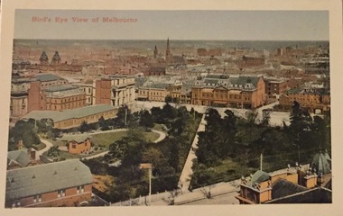
Postcard, Bird's Eye View of Melbourne, c.1911
Collection of thirty-nine postcards donated by Jillian Rigby which had been owned by her grandparents, George and Edith Weir, who from c.1917 lived at 84 Princess Street, Kew. The mostly 'mint' postcards were purchased in Victoria and while travelling overseas. The sole dated postcard is dated from 1929. The postcards are numbered sequentially from 2017.0058.01-39. The remainder of the collection donated by Jill Rigby which was once owned by the Weirs of Broken Hill and Kew consist of costumes, costume accessories, photographs, and documents.The postcards in the Weir collection, especially those purchased on a trip or trips to the mother country, i.e. United Kingdom, represent a representative sample of sites that were considered significant to those Australians undertaking a reverse grand tour by member of the erstwhile colonies. Those postcards which are early views of Melbourne must have been produced commercially for some decades from the early part of the 20th century.Bird's eye view of Melbourne looking across a park to the Princess Theatre. Coloured postcard. Weir collection."Bird's Eye View of Melbourne"postcards, george and edith weir, princess theatre, eastern hill - melbourne, weir collection -
 Kew Historical Society Inc
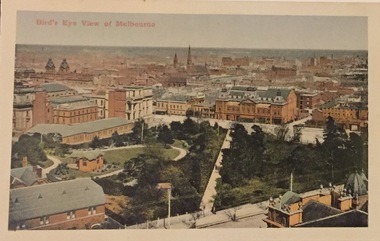
Postcard, Bird's Eye View of Melbourne, c.1911
Collection of thirty-nine postcards donated by Jillian Rigby which had been owned by her grandparents, George and Edith Weir, who from c.1917 lived at 84 Princess Street, Kew. The mostly 'mint' postcards were purchased in Victoria and while travelling overseas. The sole dated postcard is dated from 1929. The postcards are numbered sequentially from 2017.0058.01-39. The remainder of the collection donated by Jill Rigby which was once owned by the Weirs of Broken Hill and Kew consist of costumes, costume accessories, photographs, and documents.The postcards in the Weir collection, especially those purchased on a trip or trips to the mother country, i.e. United Kingdom, represent a representative sample of sites that were considered significant to those Australians undertaking a reverse grand tour by member of the erstwhile colonies. Those postcards which are early views of Melbourne must have been produced commercially for some decades from the early part of the 20th century.Bird's eye view of Melbourne looking across a park to the Princess Theatre. Coloured postcard. Weir collection."Bird's Eye View of Melbourne"postcards, george and edith weir, princess theatre, eastern hill - melbourne, weir collection -
 Kew Historical Society Inc
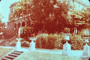
Photograph - 'Raheen', 96 Studley Park Road
Raheen was constructed as a two-storey house in the Italianate style with a four-storey tower over the entrance and single-storey extension. It was designed in an asymmetric and arcaded form, and is built of red brick with cement render. The property retains its garden layout, including an Italianate garden, outbuildings, fence and gates, and internal features including the original stairwell, library, ballroom and cast iron tower stairs. (source VHD)View of the upper and lower eastern loggias of 'Raheen' at 96 Studley Park Road, Kew from the eastern garden. The colour photo shows the pedestals and urns above the steps and the plantings in the garden c.1980. raheen -- 96 studley park road -- kew (vic.), historic houses -- studley park, mansions -- kew (vic.) -
 Kew Historical Society Inc
Photograph - Yarra Valley Floods: Kew East, 1916
Flooding of the Yarra Valley, including that section of the Yarra bordering Kew and Kew East in the north and west of the municipality, was a regular occurrence. Extreme flood events of the Yarra River are recorded to have occurred in 1891, 1901, 1916, 1923 and 1934. The Municipality of Kew's response to these floods was to enact planning decisions restricting residential development in flood prone areas following the floods of 1916, 1921 and 1934. While floods continued after the development of the Upper Yarra Reservoir (construction 1948-57), the regularity and extent of these inundations diminished. During the nineteenth century, the land abutting the south side of the Yarra in Kew was devoted to dairy farming. In the twentieth century, before and after the construction of the Eastern Freeway, much of this low-lying area was used as golf courses and public parks.One of a collection of photographs of flooding in the Kew section of the Yarra Valley which are in important research resource for the location and extent of flooding in the first half of the twentieth century. Flooding of the Yarra Valley at East Kew in 1916. The view is taken from the intersection of Kilby Road with what is believed to be Birdwood Street, looking across the flood waters to Ivanhoe. The extensive flooded area shown in the photograph would have included the Kew Golf Club. Verso: "Floods along Kilby Road / near Birdwood St? & Kilby Road / 1917? / 87yarra river, yarra valley, floods -- kew, kilby road -- kew (vic.), kew golf club -
 Kew Historical Society Inc
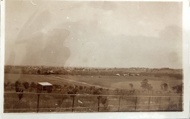
Photograph - Yarra Valley at Kew, 1918
During the nineteenth century, the land abutting the south side of the Yarra in Kew was devoted to dairy farming. In the twentieth century, before and after the construction of the Eastern Freeway, much of this low-lying area was used as golf courses and public parks.View of the farmland in the Yarra Valley at what is believed to be East Kew in 1918. Verso: "Willsmere / East Kew? / 1918"yarra river, yarra valley -
 Kew Historical Society Inc
Photograph - Yarra Valley Floods: Kew East, 1916
Flooding of the Yarra Valley, including that section of the Yarra bordering Kew and Kew East in the north and west of the municipality, was a regular occurrence. Extreme flood events of the Yarra River are recorded to have occurred in 1891, 1901, 1916, 1923 and 1934. The Municipality of Kew's response to these floods was to enact planning decisions restricting residential development in flood prone areas following the floods of 1916, 1921 and 1934. While floods continued after the development of the Upper Yarra Reservoir (construction 1948-57), the regularity and extent of these inundations diminished. During the nineteenth century, the land abutting the south side of the Yarra in Kew was devoted to dairy farming. In the twentieth century, before and after the construction of the Eastern Freeway, much of this low-lying area was used as golf courses and public parks.One of a collection of photographs of flooding in the Kew section of the Yarra Valley which are in important research resource for the location and extent of flooding in the first half of the twentieth century. Flooding of the Yarra Valley at East Kew in 1916. The view is taken from a street (maybe Birdwood Avenue) intersecting with Kilby Road looking northeast across the flood waters to Ivanhoe and Heidelberg. The extensive flooded area shown in the photograph would have included remnant dairy farms and the Kew Golf Club. Verso: "Floods / Yarra River / East Kew / Kilby Road / 1917? / 87"yarra river, yarra valley, floods -- kew, kilby road -- kew (vic.), kew golf club -
 Kew Historical Society Inc
Photograph - Yarra Valley at Kew, 1912
During the nineteenth century, the land abutting the south side of the Yarra in Kew was devoted to dairy farming. In the twentieth century, before and after the construction of the Eastern Freeway, much of this low-lying area was used as golf courses and public parks.Real-photo postcard of the farmland in the Yarra Valley in what is believed to be North Kew in 1912. Verso: "Willsmere / East Kew / 1912"yarra river, yarra valley, farming -- kew (vic.) -
 Kew Historical Society Inc
Photograph - Willsmere [Kew] Billabong, 1993
Willsmere Park is bounded by the the Yarra River, Green Acres Golf Club, Willow Grove and the Eastern Freeway. The land on which the park is now situated was bought by Thomas Wills at the Crown Land Sales of 1846 (Section 56). From the 1840s to the 1940s it was intensively farmed. The park is dominated by very large playing fields, while planting to the southern boundary was undertaken when the Eastern Freeway was built. It is only along the banks of the Yarra that there is any remnant native vegetation. Willsmere Park is of significance as an area of open land that remains from the flood plain that once dominated northern Kew. (Source: Kew Conservation Study, 1988)Original colour small format polaroid photograph of the 'Kew Billabong' in the Willsmere Park, taken on 16 September 1993."Willsmere Billabong 16.9.93"kew billabong, willsmere park, yarra river -- billabongs -
 Kew Historical Society Inc
Photograph - Yarra River in flood at the Willsmere Park, 1993
Willsmere Park is bounded by the the Yarra River, Green Acres Golf Club, Willow Grove and the Eastern Freeway. The land on which the park is now situated was bought by Thomas Wills at the Crown Land Sales of 1846 (Section 56). From the 1840s to the 1940s it was intensively farmed. The park is dominated by very large playing fields, while planting to the southern boundary was undertaken when the Eastern Freeway was built. It is only along the banks of the Yarra that there is any remnant native vegetation. Willsmere Park is of significance as an area of open land that remains from the flood plain that once dominated northern Kew. (Source: Kew Conservation Study, 1988)Original colour small format polaroid photograph of the Yarra River in flood at the Willsmere Park, taken on 16 September 1993."Yarra River at Willsmere Park Flooding 16.9.93"willsmere park, yarra river -- floods -- kew (vic.) -
 Kew Historical Society Inc
Photograph - Flooding in the Willsmere Park, 1993
Willsmere Park is bounded by the the Yarra River, Green Acres Golf Club, Willow Grove and the Eastern Freeway. The land on which the park is now situated was bought by Thomas Wills at the Crown Land Sales of 1846 (Section 56). From the 1840s to the 1940s it was intensively farmed. The park is dominated by very large playing fields, while planting to the southern boundary was undertaken when the Eastern Freeway was built. It is only along the banks of the Yarra that there is any remnant native vegetation. Willsmere Park is of significance as an area of open land that remains from the flood plain that once dominated northern Kew. (Source: Kew Conservation Study, 1988)Original colour small format polaroid photograph of flooding in the Willsmere Park, taken on 16 September 1993."Flooding of shared path from Willsmere Billabong 16.9.93"willsmere park, yarra river -- floods -- kew (vic.), kew billabong -
 Kew Historical Society Inc
Photograph - Flooding in the Willsmere Park, 1993
Willsmere Park is bounded by the the Yarra River, Green Acres Golf Club, Willow Grove and the Eastern Freeway. The land on which the park is now situated was bought by Thomas Wills at the Crown Land Sales of 1846 (Section 56). From the 1840s to the 1940s it was intensively farmed. The park is dominated by very large playing fields, while planting to the southern boundary was undertaken when the Eastern Freeway was built. It is only along the banks of the Yarra that there is any remnant native vegetation. Willsmere Park is of significance as an area of open land that remains from the flood plain that once dominated northern Kew. (Source: Kew Conservation Study, 1988)Original colour small format polaroid photograph of flooding in the Willsmere Park, taken on 16 September 1993."Flooding of Willsmere Park from Yarra 16.9.93"willsmere park, yarra river -- floods -- kew (vic.) -
 Kew Historical Society Inc
Photograph - Flooding of Willsmere Park from Yarra, 1993
Willsmere Park is bounded by the the Yarra River, Green Acres Golf Club, Willow Grove and the Eastern Freeway. The land on which the park is now situated was bought by Thomas Wills at the Crown Land Sales of 1846 (Section 56). From the 1840s to the 1940s it was intensively farmed. The park is dominated by very large playing fields, while planting to the southern boundary was undertaken when the Eastern Freeway was built. It is only along the banks of the Yarra that there is any remnant native vegetation. Willsmere Park is of significance as an area of open land that remains from the flood plain that once dominated northern Kew. (Source: Kew Conservation Study, 1988)Original colour small format polaroid photograph of flooding in Willsmere Park resulting from heavy rain on 15 September 1993."Flooding of Willsmere Park from Yarra 16.9.93"yarra river -- floods -- kew (vic.), willsmere park -
 Kew Historical Society Inc
Photograph - Willsmere [Kew] Billabong, 1993
Willsmere Park is bounded by the the Yarra River, Green Acres Golf Club, Willow Grove and the Eastern Freeway. The land on which the park is now situated was bought by Thomas Wills at the Crown Land Sales of 1846 (Section 56). From the 1840s to the 1940s it was intensively farmed. The park is dominated by very large playing fields, while planting to the southern boundary was undertaken when the Eastern Freeway was built. It is only along the banks of the Yarra that there is any remnant native vegetation. Willsmere Park is of significance as an area of open land that remains from the flood plain that once dominated northern Kew. (Source: Kew Conservation Study, 1988)Original colour small format polaroid photograph of Willsmere [Kew] Billabong on September 1993."Willsmere Billabong 16.9.93"yarra river -- floods -- kew (vic.), willsmere park -
 Kew Historical Society Inc
Photograph - Flooding of the Yarra Valley at Kew East, 1974
Flooding of the Yarra Valley, including that section of the Yarra bordering Kew and Kew East in the north and west of the municipality, was a regular occurrence. Extreme flood events of the Yarra River are recorded to have occurred in 1891, 1901, 1916, 1923 and 1934. The Municipality of Kew's response to these floods was to enact planning decisions restricting residential development in flood prone areas following the floods of 1916, 1921 and 1934. While floods continued after the development of the Upper Yarra Reservoir (construction 1948-57), the regularity and extent of these inundations diminished. During the nineteenth century, the land abutting the south side of the Yarra in Kew was devoted to dairy farming. In the twentieth century, before and after the construction of the Eastern Freeway, much of this low-lying area was used as golf courses and public parks.Late example of the capacity of the Yarra Valley at Kew to flood, even though drainage works and the Upper Yarra Reservoir had reduced their regularity.Original black and white print photograph of the low-lying land at East Kew under floodwater on 16 May 1974. The vantage point of the photographer is Lister Street. In the photo, the fences of the Kilby Farm can be seen. Flooding was caused by overflowing water in Glass' Creek and the River Yarra. Annotation verso: "Hay's Paddock op No.30 Lister Street / 16 May 1974 11.50am / R.L. 46.04"hays paddock, floods, yarra river, glass' creek, lister street -
 Kew Historical Society Inc
Photograph - Flooding of the Yarra Valley at Kew East, 1974
Flooding of the Yarra Valley, including that section of the Yarra bordering Kew and Kew East in the north and west of the municipality, was a regular occurrence. Extreme flood events of the Yarra River are recorded to have occurred in 1891, 1901, 1916, 1923 and 1934. The Municipality of Kew's response to these floods was to enact planning decisions restricting residential development in flood prone areas following the floods of 1916, 1921 and 1934. While floods continued after the development of the Upper Yarra Reservoir (construction 1948-57), the regularity and extent of these inundations diminished. During the nineteenth century, the land abutting the south side of the Yarra in Kew was devoted to dairy farming. In the twentieth century, before and after the construction of the Eastern Freeway, much of this low-lying area was used as golf courses and public parks.Late example of the capacity of the Yarra Valley at Kew to flood, even though drainage works and the Upper Yarra Reservoir had reduced their regularity.Original black and white print photograph of the low-lying land at East Kew under floodwater on 16 May 1974. The vantage point of the photographer is Lister Street. Flooding was caused by overflowing water in Glass' Creek and the River Yarra. Annotation verso: "Lister Street looking north / Flood level / 16 May 1974 11.30am / R.L. 46.04"hays paddock, floods, yarra river, glass' creek, lister street -
 Kew Historical Society Inc
Photograph - Flooding of the Yarra Valley at Kew East, 1974
Flooding of the Yarra Valley, including that section of the Yarra bordering Kew and Kew East in the north and west of the municipality, was a regular occurrence. Extreme flood events of the Yarra River are recorded to have occurred in 1891, 1901, 1916, 1923 and 1934. The Municipality of Kew's response to these floods was to enact planning decisions restricting residential development in flood prone areas following the floods of 1916, 1921 and 1934. While floods continued after the development of the Upper Yarra Reservoir (construction 1948-57), the regularity and extent of these inundations diminished. During the nineteenth century, the land abutting the south side of the Yarra in Kew was devoted to dairy farming. In the twentieth century, before and after the construction of the Eastern Freeway, much of this low-lying area was used as golf courses and public parks.Late example of the capacity of the Yarra Valley at Kew to flood, even though drainage works and the Upper Yarra Reservoir had reduced their regularity.Original black and white print photograph of Hay's Paddock under floodwater on 16 May 1974. The vantage point of the photographer is Keystone Crescent looking east. Flooding was caused by overflowing water in Glass' Creek and the River Yarra. Annotation verso: "Keystone Cr looking east / 16 May 1974 11.50am"hays paddock, floods, yarra river, glass' creek -
 Kew Historical Society Inc
Photograph - Flooding of the Yarra Valley at Kew East, 1974
Flooding of the Yarra Valley, including that section of the Yarra bordering Kew and Kew East in the north and west of the municipality, was a regular occurrence. Extreme flood events of the Yarra River are recorded to have occurred in 1891, 1901, 1916, 1923 and 1934. The Municipality of Kew's response to these floods was to enact planning decisions restricting residential development in flood prone areas following the floods of 1916, 1921 and 1934. While floods continued after the development of the Upper Yarra Reservoir (construction 1948-57), the regularity and extent of these inundations diminished. During the nineteenth century, the land abutting the south side of the Yarra in Kew was devoted to dairy farming. In the twentieth century, before and after the construction of the Eastern Freeway, much of this low-lying area was used as golf courses and public parks.Late example of the capacity of the Yarra Valley at Kew to flood, even though drainage works and the Upper Yarra Reservoir had reduced their regularity.Original black and white print photograph of the low-lying land at East Kew under floodwater on 16 May 1974. The vantage point of the photographer is Lister Street. Flooding was caused by overflowing water in Glass' Creek and the River Yarra. Annotation verso: "Lister St looking same as No.3 / 16 May 1974 11.30"floods, yarra river, glass' creek, lister street -
 Kew Historical Society Inc
Photograph - Flooding of the Yarra Valley at Kew East, 1974
Flooding of the Yarra Valley, including that section of the Yarra bordering Kew and Kew East in the north and west of the municipality, was a regular occurrence. Extreme flood events of the Yarra River are recorded to have occurred in 1891, 1901, 1916, 1923 and 1934. The Municipality of Kew's response to these floods was to enact planning decisions restricting residential development in flood prone areas following the floods of 1916, 1921 and 1934. While floods continued after the development of the Upper Yarra Reservoir (construction 1948-57), the regularity and extent of these inundations diminished. During the nineteenth century, the land abutting the south side of the Yarra in Kew was devoted to dairy farming. In the twentieth century, before and after the construction of the Eastern Freeway, much of this low-lying area was used as golf courses and public parks.Late example of the capacity of the Yarra Valley at Kew to flood, even though drainage works and the Upper Yarra Reservoir had reduced their regularity.Original black and white print photograph of the low-lying land at East Kew under floodwater on 16 May 1974. The vantage point of the photographer is at Willsmere Road. The road itself is underwater.Annotation verso: "Willsmere Rd / Same as No.7 / 16 May 1974 11.15am"floods, yarra river, willsmere road -
 Kew Historical Society Inc
Photograph - Flooding of the Yarra Valley at Kew East, 1974
Flooding of the Yarra Valley, including that section of the Yarra bordering Kew and Kew East in the north and west of the municipality, was a regular occurrence. Extreme flood events of the Yarra River are recorded to have occurred in 1891, 1901, 1916, 1923 and 1934. The Municipality of Kew's response to these floods was to enact planning decisions restricting residential development in flood prone areas following the floods of 1916, 1921 and 1934. While floods continued after the development of the Upper Yarra Reservoir (construction 1948-57), the regularity and extent of these inundations diminished. During the nineteenth century, the land abutting the south side of the Yarra in Kew was devoted to dairy farming. In the twentieth century, before and after the construction of the Eastern Freeway, much of this low-lying area was used as golf courses and public parks.Late example of the capacity of the Yarra Valley at Kew to flood, even though drainage works and the Upper Yarra Reservoir had reduced their regularity.Original black and white print photograph of the low-lying land at East Kew under floodwater on 16 May 1974. The photograph is of Hyde Park looking north-east.Annotation verso: "Hyde Park looking nth-east / Flood Level / 16 May 1974 11.15am / R.L. 46.61"floods, yarra river, hyde park -
 Kew Historical Society Inc
Photograph - Flooding of the Yarra Valley at Kew, 1974
Flooding of the Yarra Valley, including that section of the Yarra bordering Kew and Kew East in the north and west of the municipality, was a regular occurrence. Extreme flood events of the Yarra River are recorded to have occurred in 1891, 1901, 1916, 1923 and 1934. The Municipality of Kew's response to these floods was to enact planning decisions restricting residential development in flood prone areas following the floods of 1916, 1921 and 1934. While floods continued after the development of the Upper Yarra Reservoir (construction 1948-57), the regularity and extent of these inundations diminished. During the nineteenth century, the land abutting the south side of the Yarra in Kew was devoted to dairy farming. In the twentieth century, before and after the construction of the Eastern Freeway, much of this low-lying area was used as golf courses and public parks.Late example of the capacity of the Yarra Valley at Kew to flood, even though drainage works and the Upper Yarra Reservoir had reduced their regularity.Original black and white print photograph of the low-lying land at East Kew under floodwater on 16 May 1974. The photograph is taken from 43 Kellett Grove.Annotation verso: "Kellett Gve No.43 / Flood Level / 16 May 1974 11.40am"floods, yarra river, kellett grove -
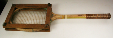 Tennis Australia
Racquet, Circa 1945
... Park Melbourne melbourne Tennis Eastern Sea brand wood tennis ...Eastern Sea brand wood tennis racquet with non-matching head press. Marked in several places with owner's name: 'Joan P. Sansom'. Materials: Metal, Wood, Leathertennis -
 Glen Eira City Council History and Heritage Collection
Document (Item) - Newspaper (digital), Caulfield Contact
The Caulfield Contact was the official newspaper of the City of Caulfield from 1976-1994. The City of Caulfield was the Municipal Council for an area of the South Eastern suburbs of Melbourne, including Brighton East, Carnegie, Caulfield, Elsternwick, Gardenvale, Glen Huntly, McKinnon, Murrumbeena, Ormond and St Kilda East. Following Amalgamation of City of Caulfield and parts of the City of Moorabbin in 1994, the Caulfield Contact was followed by the Glen Eira News. Includes references to the following: Children's Neighbourhood Centre Caulfield; Fire destroyed Caulfield Park Bowling Club; Naming of Harleston Park; Home Handyman Service; Profiles Councillors Peter Baitz, Ron Walters; Carnegie-Glenhuntly Football Club formed Council drops approval of rail crossings over Neerim and Glenhuntly Roads; Profiles Councillor Alwyn Samuel, Glen Richards; First stage of Nepean Highway widening; Minister approved re-subdivision; Council spills; Exciting development of Caulfield Park; Profiles Councillor Max Blair, Councillor Brian Rudzki; Tram shelter classified by National Trustcity of caulfield, caulfield, glen eira, city of glen eira, caulfield contact, children's neighbourhood centre caulfield, fire destroyed caulfield park bowling club, naming of harleston park, home handyman service, profiles councillors peter baitz, ron walters, carnegie-glenhuntly football club formed, council drops approval of rail crossings over neerim and glenhuntly roads, profiles councillor alwyn samuel, glen richards, first stage of nepean highway widening, minister approved re-subdivision, council spills, exciting development of caulfield park, profiles councillor max blair, councillor brian rudzki, tram shelter classified by national trust -
Glen Eira City Council History and Heritage Collection
Document (Item) - Newspaper (digital), Caulfield Contact
The Caulfield Contact was the official newspaper of the City of Caulfield from 1976-1994. The City of Caulfield was the Municipal Council for an area of the South Eastern suburbs of Melbourne, including Brighton East, Carnegie, Caulfield, Elsternwick, Gardenvale, Glen Huntly, McKinnon, Murrumbeena, Ormond and St Kilda East. Following Amalgamation of City of Caulfield and parts of the City of Moorabbin in 1994, the Caulfield Contact was followed by the Glen Eira News. Contains References to the following Freedom of Entry to 3rd ordinance of the RAAOC, visit by Sir Zelman Cowen, Return to Rosstown, A 'spacy new home' (nursery at Caulfield Park), Profile on Gus Theobold, Meals on Wheels Aviary completed Caulfield Park. Profile resident Gus Theobold. Cr Irene Capek win Herald Australia Day essay prize. Caulfields Meals on Wheels set Victorian record. Historical feature Return to Rosstown. New ambulance station Glenhuntly and Clarinda roads opens. Volume 4 Number 5 Date 03 August 1978 Features Where and How to Vote in council election. Cr Irene Capek retires from council. Profiles election candidates. Image: Image Cr Irene Capek. Images of election candidates. Volume 5 Number 1 Date 14 September 1978 Freedom of Entry to 3rd ordinance of the RAAOC, visit by Sir Zelman Cowen, Subjects from Carol: GG Sir Zelman Cowen and Lady Cowen offical visit. Off street carpark project underway Pyne St and Hawthorn Rd. City Manager Graeme Caldwell submits plans for Townhall renovations. Action plan for development of Elsternwich Shopping precint to be developed. Freedom of Entry ceremony. Profile Rosemary Keppel. Booran Motors Glenhuntly donate dual control Holden Gemini to Caulfield Tech school pre-driver education program. council election results. Comments from elected Crs Jack Campell, Bob Baxter, Dorothy Ford, Brian Rudzki. Promotion of Caulfield Institute of Technology and TAFE. Image: Image Sir Zelman Cowen, Lady Cowen. Images Freedom of Entry ceremony and citizens attending. Image Rosemary Keppel. Cartoon pre-driver education program. Image Mayor Cr Geoff Patience in robes. Volume 5 Number 2 Date 26 October 1978 Rate rise 5.73% announced. Readership of Caulfield Contact surveyed. Caulfield ranger Reg Dixon and members of works dept rescue duck family from drain and reinstate them to Caulfield Racecourse dam. Profile resident and teacher Claire Manning. Image: Image of Reg Dixon and the rescued ducks. Image Claire Manning and students at Waverley Private school. city of caulfield, caulfield, glen eira, city of glen eira, caulfield contact, freedom of entry to 3rd ordinance of the raaoc, visit by sir zelman cowen, return to rosstown, a 'spacy new home' (nursery at caulfield park), profile on gus theobold, meals on wheels -
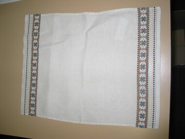 Brimbank City Council Art Collection
Textile - Towel, Embroidery, Untitled, Unknown
... Community Arts Centre 775 Ballarat Road Deer Park melbourne krystyna ...Folk ArtKlym, Krystyna Klym,Blue Flower Design, n.d, Cotton embroidery, Brimbank City Council Art Collection, BrimbankEmbroidered cotton fabrickrystyna klym, eastern europe, embroidery -
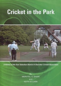 Surrey Hills Historical Society Collection
Book, G.I.Printing and Graphics Pty Ltd, Cricket in the Park: a history of the East Suburban District and Churches' cricket association, 2009
The cricket body first founded in the Eastern Suburbs to provide cricket for those associated with the churches in that area, was the Eastern Suburbs Sunday Schools' Association. It later combined with the Camberwell Districts Churches Association in 1925. This book covers Part 1 and Part 2 of their history. The cricket body first founded in the Eastern Suburbs to provide cricket for those associated with the churches in that area, was the Eastern Suburbs Sunday Schools' Association. It later combined with the Camberwell Districts Churches Association in 1925. This book covers Part 1 and Part 2 of their history.east suburban churches cricket associations, cricket, camberwell districts, churches associations, 1925 -
Public Record Office Victoria
Legal record (item) - Divorce Papers for Frank Paice and Florence Paice (otherwise Cox)
A file previously held in the collection of the Supreme Court of Victoria and now in Public Record Office Victoria contains records of the annulment of the marriage of Florence Cox in 1919. As the earliest known record of a person with intersex variations in Victorian history, Cox’s story – and this record – are of unique historical significance to the LGBTIQ+ history of the State. Florence Cox (1887–1950) had a middle-class upbringing in Melbourne. In 1914 she travelled to Bengal to marry her fiancé Frank Paice and to join him in his missionary work for the Baptist church. The couple returned to Melbourne in 1918 and the following year the Supreme Court of Victoria, at Paice’s request, annulled their marriage. The Supreme Court file reveals that Paice declared he had been unable to consummate the marriage, due to ‘a malformation frigidity or other defect of the parts of generation’ of his wife. Both Paice and Cox were subject to medical examination, which established that Cox had what is recognised today as the intersex condition complete androgen insensitivity syndrome. The court determined that marital intercourse, as it was understood at the time, was impossible for Paice and Cox, and granted the request for an annulment. Paice remarried, fathered children and led a successful professional and civic life, serving a period as Mayor of Nunawading, in the middle- class eastern suburbs of Melbourne. Cox’s life was very different. It is unlikely that anyone in her life would have known what had prompted the end of the marriage, but gossip would certainly have focussed on her part in it. She never remarried and, although she remained connected to her family, her story was rarely discussed. Cox was admitted to Mont Park Mental Hospital in Melbourne’s northern suburbs in 1945, where she died five years later. The Supreme Court file preserves one of the most detailed medical descriptions of a person with intersex variations from that period. It is particularly striking that following the court case, the file was closed ‘forever’. This indicates how seriously the court took the case, and its determination to protect Cox and Paice from public scrutiny. It speaks loudly to the thinking of the time on a matter that was rarely, if ever, raised in public. In 1997, Cox’s great-nephew Ian Richardson set out to investigate the secrecy surrounding his great-aunt Florrie. Following a relentless, two-year campaign by Richardson and other descendants of Cox and Paice, the Supreme Court file was finally opened to the public. Richardson’s book, God’s Triangle, recounts his quest and brings Cox’s story out of the archives and into the light. Quoted from "A History of LGBTIQ+ Victoria in 100 Places and Objects" by Graham Willett, Angela Bailey, Timothy W. Jones and Sarah Rood. -
Carlton Football Club
Brochure, The Blues Seat For Life Program - Brochure, 1996
Brochure advertising "The Blues Seat For Life Program" prior to the 1996 season and the opening of the new Eastern End Stand at Princes Park. This program gave members first opportunity to renew their reserved seat for following seasons.small coloured brochure