Showing 1942 items matching " flooding"
-
 Kew Historical Society Inc
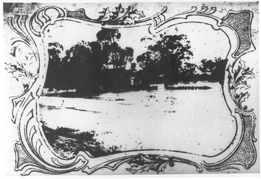
Photograph - Burgess House, Victoria Street (Abbotsford), 1880-1900
Major floods recurred of the Yarra River on a regular basis. A flood in 1901 destroyed this house in Victoria Street, Abbotsford. Later print copy of an original photograph. Home of C/N Burgess on the south side of Yarra River. The buildings were washed away in a flood in 1901 The house was in the same location as that on which Handley & Tilly was later built. This would locate it on the north side of Victoria Street, Abbotsford between Burnley Street and the Victoria Street Bridge. Photo shows three men and one woman working in an established garden in front of a weatherboard cottage."Home of C/N Burgess on south side of river; washed away in 1901; Handley & Tilly on site"yarra river -- floods, yarra river flood -- 1901, burgess family -- victoria street -- abbotsford (vic.) -
 Orbost & District Historical Society
newspaper, Snowy River Mail, 29.3.1950
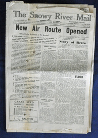
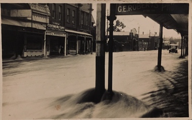
The Snowy River Mail is a weekly newspaper published in Orbost in the Shire of East Gippsland, Victoria, Australia. Previously published as The Snowy River mail and Tambo and Croajingolong gazette from 1890 to 1911. The Gippsland Courier merged with the Snowy River Mail when proprietor Lachlan Ross moved to Orbost in 1910. In 1999 the paper was acquired by the Yeates family when the Hollins family retired from the newspapers business. The paper is still being produced by the fourth generation of the Yeates family as part of East Gippsland Newspapers. The 1950 flood was a significant event in Orbost. This newspaper is a contemporary record of a significant local events.A Snowy River Mail newspaper dated 29.3.1950. It contains news articles and advertisements in black/white print. it contains an article on the flood at that time.snowy-river-mail 1950-flood newspaper -
 Orbost & District Historical Society
newspaper clippings, February 1971
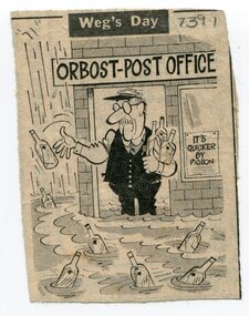
These articles were compiled by Mary Gilbert who was the first curator of the Orbost Museum and a prominent historian / teacher in Orbost. The 1971 floods at Orbost were the worst on record. At Jarrahmond the river rose to a height of 11 metres and on the flats spread to one and a half kilometres wide. Considerable damage was done to railway infrastructure, roads and farms. More information from the APRIL, 2008 newsletter by John Phillips. (see orbosthistory.com.au)These articles are contemporary records of a significant historical event in Orbost.A manila folder containing black / white newspaper clippings from various publishers. They all relate to the 1971 floods in Orbost. (Details of contents in catalogue 735-900)floods-orbost-1971 -
 Melbourne Tram Museum
Photograph - Black & White Photograph/s, The Age, 17/02/1972 12:00:00 AM
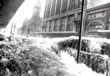
... Flooding ...Black and white photograph of a flood in Elizabeth St, with the GPO, Royal Arcade and London Stores in the background. Taken at the intersection with Flinders Lane. Shows a car with water washing over it and a safety zone in the background. Photograph by The Age, has a copy right stamp on the rear. Follows a massive downpour around the Queen Victoria Market. The cataloguer was working nearby in Collins St at the time, but no camera! See TMSV Running Journal April 1972 for details of the event.On the rear in pencil "Thursday 17/2/72 4 to 5pm, 3" Rain"trams, tramways, flooding, elizabeth st, gpo -
 Orbost & District Historical Society
newspaper, 15.2.1950
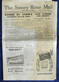
The Snowy River Mail is a weekly newspaper published in Orbost in the Shire of East Gippsland, Victoria, Australia. Previously published as The Snowy River mail and Tambo and Croajingolong gazette from 1890 to 1911. The Gippsland Courier merged with the Snowy River Mail when proprietor Lachlan Ross moved to Orbost in 1910. In 1999 the paper was acquired by the Yeates family when the Hollins family retired from the newspapers business. The paper is still being produced by the fourth generation of the Yeates family as part of East Gippsland Newspapers. The flood in 1950 was a significant Orbost event. This newspaper is a contemporary record of a significant local events.A Snowy River Mail newspaper dated 15,.2.1950. It contains news articles and advertisements in black/white print. There is an artcle about the Orbost floods.newspaper snowy-river-mail flood-1950-orbost -
 Glenelg Shire Council Cultural Collection
Slide - Glass Slide - Horses in a flood, n.d
Glass slide - horses in a flood -
 Tatura Irrigation & Wartime Camps Museum
Photograph, Flood Streetscape
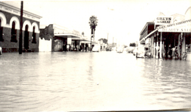
Hogan Street 1955 floodtatura, buildings, historic -
 Melton City Libraries
Photograph, Melton Weir, 1970
Spillway, bridge and river in flood.misc. -
 Melton City Libraries
Photograph, Flood at Toolern Creek, Unknown
Photos of a flood at Toolern Creeklandscapes of significance -
 Bendigo Historical Society Inc.
Newspaper - JENNY FOLEY COLLECTION: FLOOD
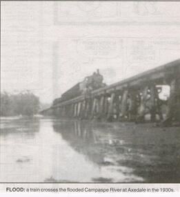
Bendigo Advertiser "the way we were" from 1999. Flood: a train crosses the flooded Campaspe river at Axedale in the 1930s.newspaper, bendigo advertiser, the way we were -
 Eltham District Historical Society Inc
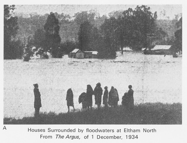
Work on paper (Sub-Item) - Photograph, Houses surrounded by floodwaters at Eltham North
... flooding ..."The house (centre) at North Eltham in which Mr. and Mrs. William Frizell, an elderly couple, were marooned by flood waters. When this photograph was taken late yesterday afternoon the couple were still inside the house, and through a ventilator they had stuck a red flag which they waved from time to time. The house on the left belongs to Mr. Leads, who also was marooned." - The Argus 1 December 1934. John William Frizell, painter and his wife Sarah Jane are registered at Glen Park, Eltham in the 1924 Electorial Roll This was most probably the Diamond Creek in flood. In 1934 extensive flooding of the Yarra River and Diamond Creek sets new records for flood plain level (via Chronology of Eltham, EDHS) flood, frizell, leads, argus, glen park, eltham north, flooding, marooned, diamond creek -
 Eltham District Historical Society Inc
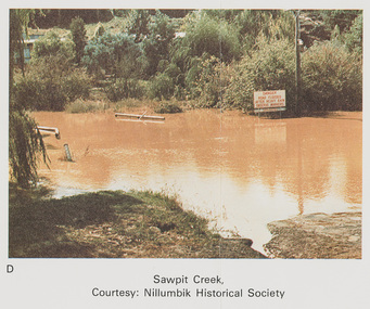
Work on paper (Sub-Item) - Photograph, Sawpit Creek in flood, Diamond Creek Township, 8 April 1977
... flooding ...Colour photograph. Sawpit Creek near the Diamond Creek in flood at Diamond Creek township, 8 April 1977 A road sign reads" DANGER ROAD FLOODED AFTER HEAVY RAIN OBSERVE MARKERS" Nillumbik Historical Society collectionflood, diamond creek, flooding, nillumbik historical society, give way, sawpit creek, campbell street, watkins street, danger, road sign -
 University of Melbourne, Burnley Campus Archives
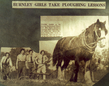
Photograph - Colour print, The Sun, Burnley Girls Take Ploughing Lessons, 1935
Photograph made by A.P. Winzenried as a possible illustration for, "Green Grows Our Garden." There was a severe flood in December 1934.2 copies colour print.. Copy of a newspaper article made by A.P. Winzenried. Caption reads, "Burnley Girls Take Ploughing Lessons. Winter tasks at the Burnley Horticultural School. Students trying their hands at the plough. New top soil had to be laid after the floods." 4 female students working with a horse drawn plough in the Orchard.Handwritten underneath, "R.Weber, E. Pearce, M. Younger, W. Wittakers. "The Sun" 12-6-35."a.p. winzenried, green grows our garden, ploughing lesson, female students, r.weber, e. pearce, m. younger, w. wittakers, orchard, 1934 flood, horse, working outside -
Glenelg Shire Council Cultural Collection
Slide - Glass Slide - Glenelg River, n.d
Glass slide - Glenelg River in floodslide, photography, glenelg river -
 Melton City Libraries
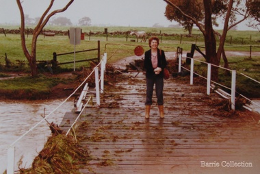
Photograph, Wendy Barrie on the Darlingsford Bridge, 1983
Property of Lot 1 Thomas Bell Darling 1853 1863 Ralph Parkinson 1887 Sold to Richard Manning (Cr and Hotelier) leased by John Walsh Minns family lived at the house in the time of Welsh. C Parkinson died in Jan 1887 Ralph Parkinson was a prominent citizen of Melton and was known for his generosity, and his involvement in the community and the Church of England. He had one daughter, his wife and other daughter died earlier. He died in Jan 1887Photo was taken during the October floodslocal identities, landscapes of significance -
Clunes Museum
Ephemera - DVD, CLUNES FLOOD 2010, 2010
CD WITH PHOTOGRAPHS OF THE 2010 FLOODS IN CLUNESclunes floods 2010, floods 04/09/2010 -
 Kew Historical Society Inc
Photograph, Chipperfield's Boat House & Floating Pontoon, 1934
Living with natural processes was frequently a challenge to early European settlers and later residents of what was in the 1850s administered by the Borondara Road Board. This was compounded by the area being bounded on three sides by rivers (Yarra River, Koonung Creek and Gardiner's Creek). In 1849, the historian James Bonwick recorded that "our district [Kew] suffered considerably. Mr Wade speaks of 80 acres, out of 100 acres of his cultivated paddock, covered by water." Newspapers continued to describe major flooding in Kew in 1863, 1869, 1878, 1880, 1889, 1891, 1916 and 1934. While the construction of the Upper Yarra dam in 1957 reduced the levels of flowing downstream, local and riverine floods continue. A number of boat houses operated on both sides of the River Yarra at Kew. Chipperfield's Boat House was located on the Yarra near the corner of Kilby and Willsmere Roads.The Kew Historical Society's pictures and map collections testify to the impact of flooding in the district. They have historical importance in documenting the extent of flooding in the district and its affects on homes, services and recreation. Numerous photographs record flooding throughout the Twentieth Century.Floating pontoon at Chipperfield's Boat House where the canoes were stored, taken in 1934, presumably before the 1934 Flood. This area of the Yarra was shallow with a number of mid river sandbanks and a popular swimming area for locals.yarra river, chipperfield's boathouse, pontoon -
 Tarnagulla History Archive
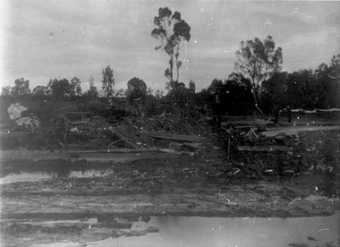
Photograph: Debris after flood, Newbridge, Debris after flood, Newbridge, 1909 (original image)
On 20th August, 1909 the Laanecoorie Weir broke away and released 18.3 million cubic metres of water through the opening and causing severe damage to all towns downstream. At Newbridge, Petersen's bakery collapsed and Simpson's Store and Hotel flooded to the roof. The billiard table was later found in a tree five miles down the Loddon near Learmonth. Murray Comrie Collection. Monochrome photograph, image depicting debris in the area near Loddon River at Newbridge after major flood in 1909. This is a very dark copy of an older original. Copy probably made by Murray Comrie in the 1960s.newbridge, loddon river, flood -
 Wycheproof & District Historical Society Inc.
Photograph, Mr Ernie Taylor, Cooroopajerrup Creek 1923, 1923 (exact)
The semi-mythical stream, the Cooroopajerrup Creek. Before there were any channel banks and formed roads, this creek shared the Avoca flood waters with the Tyrrell Creek. In more recent times the Wycheproof channel prevented the major floods of 1956 and 1973 from following the old river course. Also there is said to have been some shifting of the sand-hills at Teddywaddy which have blocked much of the old Cooroopajerrup flow. Little is known of earlier records, but The Mount Wycheproof Ensign records flooding of the creek in 1909. 2011 saw the Cooroopajerrup flow again after 88 years. This 2011 photo was taken at about the same position as the 1923 photo. The modern steel roadway fence is submerged. see-Photograph-Record No 001997.Copy of a B&W photograph of the Cooroopajerrup-Creek in flood-1923. To the north is Mount-Wycheproof, with the hospital barely visible behind the trees just left of centre, and a few scattered dwellings. The nearer railway-fence follows the road leading to the current saleyards.The outer fence has been replaced with a modern steel fence.None1923, cooroopajerrup creek, flood, mount wycheproof -
 Kew Historical Society Inc
Postcard - Flood, Glenferrie Road, Hawthorn, 1921
An item from an outstanding and diverse photographic and postcard collection, assembled by members of the Christian and Washfold families of Kew.Flood waters in Glenferrie Road. Glenferrie Meat Supply – Boyd & Winnett opposite. Car in distance in flood waters. Real photo postcardglenferrie road -- hawthorn (vic.), floods -- hawthorn (vic.), christian-washfold collection -
 Eltham District Historical Society Inc
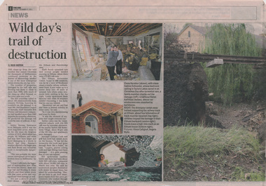
Booklet - Newspaper articles, Christmas Day Storm, 2011
... flooding ...A severe storm with damaging hail, rain and flooding impacted Melbourne on 25 December 2011 with particular damage to Eltham and Hurstbridge areas. The storm caused destablisation of parts of the Hurstbridge railway line. Wild day's trail of destruction, by Reid sexton, The Age, Tuesday, December 21, 2011, p4 Storm toll sparks rail safety fear, Reid Saxton, The Age, Tuesday, December 21, 2011, p52 newspaper articlesstorm, floods, flooding, christmas day, hurstbridge railway line -
 Kew Historical Society Inc
Photograph - Submerged houses in River Avenue, North Kew, 1934
North Kew, now divided between Kew and Kew East, bordered the Yarra River. As such, it was a region subject to flooding in the Yarra Valley. Development beyond this point (ie Kellett Grove) was limited by the City of Kew's planning regulations. Prior to urban development, the area since European settlement and the first land sales in the district in the 1840s, had been used for dairy farming. Vivid photograph contrasting domestic life and relationships with natural disasters such as the flood of 1934.Small sepia snapshot of two submerged houses belonging to local families in River Avenue, North Kew, during the 1934 floods. The view is presumably from near Kellett Grove looking north towards Fairfield.Verso: COES & HYATTS ROOF / RIVER AVENUE / Stamped: 6414yarra river -- north kew, floods -- yarra valley, floods -- north kew, floods -- 1934, natural disasters -- kew -
 Kew Historical Society Inc
Print - Walmer Street Foot Bridge
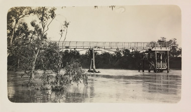
A bridge to Walmer Street, Kew, from Abbotsford was located at the northern end of Burnley Street. It was a foot bridge.Photographic print of the Walmer Street Bridge. The view of the Bridge is from the Abbotsford side of the Yarra. A section of pipe on the near side of the bridge is a remnant of the irrigation pipes that carried water from above Dight's falls to the Melbourne Botanic Gardens. The former bridge, constructed in 1896 was swept away in the 1901 Flood. It has two major brick piers while the remainder of the trestle supports are metal. The original photograph from which this copy was made was taken after 1901 as it shows the second bridge under construction. Houses in Young Street, Kew, can be seen on the far side of the river.Written on reverse: "Walmer St. Bridge. Erected 1896. Being rebuilt after 1901 flood damaged it. Houses on left are in Young St."bridges -- kew (vic.), walmer street bridge, melbourne botanic gardens -
 Ringwood and District Historical Society
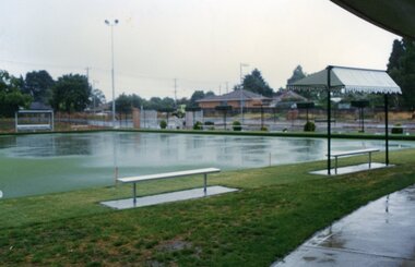
Photograph, Ringwood Bowls Club - New Ringwood Bowls Club greens flooded, 1997. Photo taken by Jim Bennett
Coloured photograph"Written on back of photograph" Greens flooded. -
 Kew Historical Society Inc
Photograph - Flood, Zig-Zag, Kew, 1924
Henry Beater Christian (1886-1962) , was a descendant of one of the earliest settler families in Kew. Employed at the Kew Asylum as a 'public servant', he was a skilled amateur photographer, photographing numerous scenes in Kew and on his travels around Victoria. The majority of his photographs date from 1916 to 1929. His finest photographs are housed in two photograph albums. A fine and clear view of the Zig-Zag Bridge across the Yarra River.Digital copy of a photograph from page 5 of the 47-page photograph album containing 261 gelatinous silver images, loaned by Diane Washfold with permission given to digitise and hold a copy in our collection. This is a photograph of the 1870s Zig-Zag Bridge that linked the Yarra Bend and Kew Asylums. The Bridge was demolished in 1929."Flood / Zig-Zag / Kew / 1.24"henry beater christian (1886-1962), landscape photography, kew (vic.) — yarra river, christian-washfold collection, photograph albums, zig-zag bridge -
 Kew Historical Society Inc
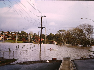
Photograph - Flooding, Kilby Road, Kew, Ron Setford, 1974
Ron Setford and his wife Grace Setford lived in Tanner Avenue, East Kew, from c.1946 to c.1995. A keen photographer, he recorded the changing face of Kew over a 20 year period. Apart from 30 photographs of built structures and places in Kew dating from 1960 and 1961, 145 of his 35mm colour slides chronicle the development of the Eastern Freeway through the Yarra Valley over a five year period from c.1972 to c.1977. This important collection was donated to the Society by his granddaughter in 2025.This collection of 175 35mm slides is of local and statewide significance, owing to its subject matter, particularly the major development of road transport infrastructure during the 1970s with the construction of the Eastern Freeway. The photographer also took care to annotate and date most of his slides which enable the researcher to pinpoint temporal and spatial locations."Flood Kilby Road / May 74"ron setford, floods -- kew (vic.), kilby road -- kew (vic.) -
 Kew Historical Society Inc
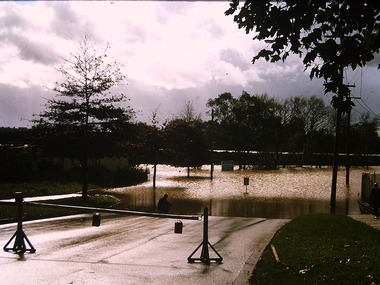
Photograph - Flooding - Kilby Road (Kew), Ron Setford, 1974
Ron Setford and his wife Grace Setford lived in Tanner Avenue, East Kew, from c.1946 to c.1995. A keen photographer, he recorded the changing face of Kew over a 20 year period. Apart from 30 photographs of built structures and places in Kew dating from 1960 and 1961, 145 of his 35mm colour slides chronicle the development of the Eastern Freeway through the Yarra Valley over a five year period from c.1972 to c.1977. This important collection was donated to the Society by his granddaughter in 2025.This collection of 175 35mm slides is of local and statewide significance, owing to its subject matter, particularly the major development of road transport infrastructure during the 1970s with the construction of the Eastern Freeway. The photographer also took care to annotate and date most of his slides which enable the researcher to pinpoint temporal and spatial locations."Flood Kilby Rd / May 74"ron setford, floods -- kew (vic.), kilby road -- kew (vic.) -
 Tarnagulla History Archive
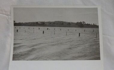
Photographs: Loddon River, Newbridge after flood, Loddon River, Newbridge after flood, 1909 (original image)
On 20th August,1909 the Laanecoorie Weir broke away and released 18.3 million cubic metres of water through the opening and causing severe damage to all towns downstream. At Newbridge, Petersen's bakery collapsed and Simpson's Store and Hotel flooded to the roof. The billiard table was later found in a tree five miles down the Loddon near Learmonth. Murray Comrie Collection. Two copies of a monochrome photograph, image depicts the area near Loddon River at Newbridge after major flood in 1909. This is a very grainy and dark copy of an older original. Copy probably made by Murray Comrie in the 1960s.newbridge, loddon river, flood, bridge -
 Tarnagulla History Archive
Photographs: Loddon River, Newbridge after flood, Loddon River, Newbridge after flood, 1909 (original image)
On 20th August,1909 the Laanecoorie Weir broke away and released 18.3 million cubic metres of water through the opening and causing severe damage to all towns downstream. At Newbridge, Petersen's bakery collapsed and Simpson's Store and Hotel flooded to the roof. The billiard table was later found in a tree five miles down the Loddon near Learmonth. Murray Comrie Collection. Two copies of a monochrome photograph, image depicts the area near Loddon River at Newbridge after major flood in 1909. This is a very grainy and dark copy of an older original. Copy probably made by Murray Comrie in the 1960s.newbridge, loddon river, flood, bridge -
 Ballarat Heritage Services
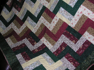
Photograph - Colour, Patchwork quilt made by ladies, Devonport, Tasmania
Photograph of a quilt made for the Carisbrook flood victims.