Showing 1359 items
matching parks and reserves
-
 Port Melbourne Historical & Preservation Society
Photograph - Friends of the Park float, Port Melbourne Festival, Pat Grainger, Feb 1989
This float was created by members of Friends of the Park, a group formed in 1987 against government proposals to turn the railway and reservation into a grand boulevard to service the proposed Sandridge City 'bayside' development. Members worked for months to make the decorations, added to a trailer. During the festival procession sausages were BBQ'd on the trailer and handed out to the crowd. On arrival at Murphy's Reserve all floats were put out of sight, and few saw the results of their efforts.One of 16 colour photos of Friends of the Park float for the February 1989 Port Melbourne Festival: Preparations for the procession forming by the Raglan Street flats - Jan Fly, Andrea Ellis and Marilyn Tullochcelebrations fetes and exhibitions, public action campaigns, jan fly, andrea ellis, marilyn tulloch, friends of the park, port melbourne festival -
Port Melbourne Historical & Preservation Society
Photograph - Friends of the Park float, Port Melbourne Festival, Pat Grainger, Feb 1989
This float was created by members of Friends of the Park, a group formed in 1987 against government proposals to turn the railway and reservation into a grand boulevard to service the proposed Sandridge City 'bayside' development. Members worked for months to make the decorations, added to a trailer. During the festival procession sausages were BBQ'd on the trailer and handed out to the crowd. On arrival at Murphy's Reserve all floats were put out of sight, and few saw the results of their efforts.One of 16 colour photos of Friends of the Park float for the February 1989 Port Melbourne Festival: Preparations for the procession forming by the Raglan Street flats - Nellie Thackruh and Maree Menzelcelebrations fetes and exhibitions, public action campaigns, andrea ellis, friends of the park, nellie thackruh, port melbourne festival -
Port Melbourne Historical & Preservation Society
Photograph - Friends of the Park float, Port Melbourne Festival, Pat Grainger, Feb 1989
This float was created by members of Friends of the Park, a group formed in 1987 against government proposals to turn the railway and reservation into a grand boulevard to service the proposed Sandridge City 'bayside' development. Members worked for months to make the decorations, added to a trailer. During the festival procession sausages were BBQ'd on the trailer and handed out to the crowd. On arrival at Murphy's Reserve all floats were put out of sight, and few saw the results of their efforts.One of 16 colour photos of Friends of the Park float for the February 1989 Port Melbourne Festival: Float in Bay Street, Robert Frost BBQing, Nellie Thackruh the starcelebrations fetes and exhibitions, public action campaigns, friends of the park, robert frost, nellie thackruh, port melbourne festival -
Port Melbourne Historical & Preservation Society
Photograph - Friends of the Park float, Port Melbourne Festival, Pat Grainger, Feb 1989
This float was created by members of Friends of the Park, a group formed in 1987 against government proposals to turn the railway and reservation into a grand boulevard to service the proposed Sandridge City 'bayside' development. Members worked for months to make the decorations, added to a trailer. During the festival procession sausages were BBQ'd on the trailer and handed out to the crowd. On arrival at Murphy's Reserve all floats were put out of sight, and few saw the results of their efforts.One of 16 colour photos of Friends of the Park float for the February 1989 Port Melbourne Festival: Float in Bay Street, Robert Frost BBQingpublic action campaigns, celebrations fetes and exhibitions, friends of the park, robert frost, port melbourne festival -
Port Melbourne Historical & Preservation Society
Photograph - Friends of the Park float, Port Melbourne Festival, Pat Grainger, Feb 1988
This float was created by members of Friends of the Park, a group formed in 1987 against government proposals to turn the railway and reservation into a grand boulevard to service the proposed Sandridge City 'bayside' development. Members worked for months to make the decorations, added to a trailer. During the festival procession sausages were BBQ'd on the trailer and handed out to the crowd. On arrival at Murphy's Reserve all floats were put out of sight, and few saw the results of their efforts.One of 16 colour photos of Friends of the Park float for the February 1988 Port Melbourne Festival: Nellie Thackruh and Robert Frost with his BBQ on float, on Graham Street overpasscelebrations fetes and exhibitions, public action campaigns, friends of the park, nellie thackruh, robert frost, port melbourne festival -
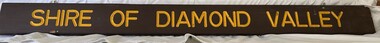 Greensborough Historical Society
Sign, Shire of Diamond Valley, Shire of Diamond Valley: Park or Reserve sign, 1964-1994
Shire of Diamond Valley timber sign. This sign would have been at the entry to one of the many public parks and reserves created during the time of the Shire of Diamond Valley (1964-1994). Following the redistribution of local government areas in 1994, the previous Shire of Diamond Valley was split between City of Banyule and Shire of Nillumbik. Signage would have been replaced to reflect the new 'owners' of the property. The exact location of this sign is unknown.Brown painted Timber sign with yellow writing etched into timbershire of diamond valley, sign, parks - greensborough -
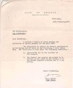 Bendigo Historical Society Inc.
Document - NORMAN OLIVER COLLECTION: ALLOCATION OF SPORTS GROUNDS FOR SCHOOLS 19 FEBRUARY 1964
The Norman Oliver collection. Norman Oliver was three times Mayor of Bendigo - 1950-51, 1964-65, 1970-71. Three typed pages - a covering letter from City Hall dated 19th February 1964, to the Head teacher regarding the allocation of sports grounds for 1964, a weekly timetable for the use of each ground by a particular school, and a list of special allocations. The grounds allocated are : Queen Elizabeth Oval, Showgrounds, Kennington, Golden Square, Ewing Park, Wilkie Park, Centenary Oval, Garden Gully, Garden Gully (new Basketball courts), North Bendigo Recreation Reserve, Allingham St., Quarry Hill, White Hills, Long Gully, and Londonderry. Weeroona Oval and the Olympic Pool are included in the special allocations list for events such as annual sports days, inter-school sports and school swimming carnivals.bendigo, council, norman joseph oliver , councillor norman oliver. mayor of bendigo. school sports. bendigo sports grounds. -
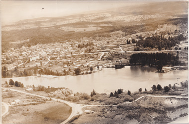 The Beechworth Burke Museum
Photograph, 1960
Taken in 1960, depicted is an aerial view of Lake Sambell and the surrounding township. Lake Sambell is a beautiful Victorian recreation lake and urban park with a unique history. It was created in the mid-1800s by the Rocky Mountain Mining company during the gold rush era and used as a mining site until the early 1900s, which brought Europeans into the area. It was turned into a reserve for residents in 1920 and is considered an icon of Beechworth as it represents the development of the community, human endeavour, and the spirit of the landscape.This photograph represents what Lake Sambell looked like in 1960.Black and white reproduced rectangular photograph print on paper.lake sambell, #beechworth, beechworth 1960s, lake, victoria, australian landscape, mining, rocky mountain mining company -
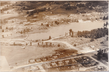 The Beechworth Burke Museum
Photograph, 1960
Taken in 1960, depicted is the construction of Lake Sambell, looking west across the lake. Lake Sambell is a beautiful Victorian recreation lake and urban park with a unique history. It was created in the mid-1800s by the Rocky Mountain Mining company during the gold rush era and used as a mining site until the early 1900s, which brought Europeans into the area. It was turned into a reserve for residents in 1920 and is considered an icon of Beechworth as it represents the development of the community, human endeavour, and the spirit of the landscape.This photograph represents additional construction to Lake Sambell as a recreational reserve.Black and white reproduced rectangular photograph print on paper.beechworth lake, lake, lake sambell, construction, #beechworth, australian landscape, beechworth 1960s, victoria -
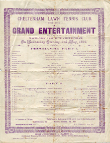 City of Moorabbin Historical Society (Operating the Box Cottage Museum)
Programme - Cheltenham Lawn Tennis Club, Grand Entertainment, 1893
Cheltenham Lawn Tennis Club was established in 1883, which was situated in the Cheltenham Park Reserve, described in its time as one of the most commanding and beautiful spots south of Melbourne. The program of a nights "Grand Entertainment" by the Cheltenham Lawn Tennis Club, held in the Mechanics Institute Cheltenham on Wednesday Evening, 3rd May 1893. Instructions for resurfacing the tennis court with colasmix and the cost associated with it. Cheltenham Lawn Tennis Club had its courts resurfaced for the Jubilee in 1887.Cheltenham Tennis Club 1883 was one of the first Tennis Clubs established in Melbourne.A Programme on a single sheet that lists the entertainment for the evening. Instruction for using Colasmix on tennis Courts and associated costs - three pages.tennis, entertainment, cheltenham lawn tennis club, cheltenham mechanics institute, charman road, cheltenham, 1920, keys john, shire of moorabbin, cheltenham park melbourne, colasmix -
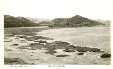
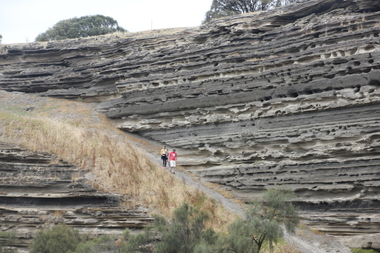 Ballarat Heritage Services
Photograph - Colour, Tower Hill, 2016, 31/12/2016
Tower Hill is a volcanic formation believed to have erupted about 32,000 years ago. Its formation is known as a "nested maar" and it is the largest example of its type in Victoria. During formation, molten lava pushed its way up through the Earth’s crust and encountered a layer of water-bearing rock. Violent explosions followed creating a shallow crater which later filled with water to form the lake. Further eruptions occurred in the centre of this crater, creating the islands and cone shaped hills. In 1892 Tower Hill became Victoria’s first National Park. In 1961, Tower Hill became a State Game Reserve under the then Fisheries and Wildlife Department and a major re-vegetation program began. (https://www.towerhill.org.au/index.php/about-reserve/history, accessed 23 December 2019)A number of photographs taken at Tower Hill, including the lakes, volcanic ash layer, and koala.tower hill, ash layer, volcano -
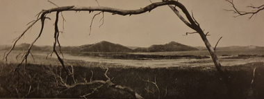 Ballarat Heritage Services
Photograph - Image, Tower Hill, Victoria, c1918, c1918
Tower Hill is a volcanic formation believed to have erupted about 32,000 years ago. Its formation is known as a "nested maar" and it is the largest example of its type in Victoria. During formation, molten lava pushed its way up through the Earth’s crust and encountered a layer of water-bearing rock. Violent explosions followed creating a shallow crater which later filled with water to form the lake. Further eruptions occurred in the centre of this crater, creating the islands and cone shaped hills. In 1892 Tower Hill became Victoria’s first National Park. In 1961, Tower Hill became a State Game Reserve under the then Fisheries and Wildlife Department and a major re-vegetation program began. (https://www.towerhill.org.au/index.php/about-reserve/history, accessed 23 December 2019)Black and white image of Tower Hill, near Koroit, Victoria.tower hill, volcano, crater -
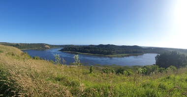
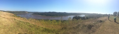 Ballarat Heritage Services
Photograph - Colour photograph, Tower Hill, 2016, 23/12/2015
Tower Hill is a volcanic formation believed to have erupted about 32,000 years ago. Its formation is known as a "nested maar" and it is the largest example of its type in Victoria. During formation, molten lava pushed its way up through the Earth’s crust and encountered a layer of water-bearing rock. Violent explosions followed creating a shallow crater which later filled with water to form the lake. Further eruptions occurred in the centre of this crater, creating the islands and cone shaped hills. In 1892 Tower Hill became Victoria’s first National Park. In 1961, Tower Hill became a State Game Reserve under the then Fisheries and Wildlife Department and a major re-vegetation program began. (https://www.towerhill.org.au/index.php/about-reserve/history, accessed 23 December 2019)Panaramic view of Tower Hill, Victoria.tower hill, volcano, crater -
 Ballarat Heritage Services
Photograph - Photograph - Black and White, Tower Hill, Victoria
Tower Hill is a volcanic formation believed to have erupted about 32,000 years ago. Its formation is known as a "nested maar" and it is the largest example of its type in Victoria. During formation, molten lava pushed its way up through the Earth’s crust and encountered a layer of water-bearing rock. Violent explosions followed creating a shallow crater which later filled with water to form the lake. Further eruptions occurred in the centre of this crater, creating the islands and cone shaped hills. In 1892 Tower Hill became Victoria’s first National Park. In 1961, Tower Hill became a State Game Reserve under the then Fisheries and Wildlife Department and a major re-vegetation program began. (https://www.towerhill.org.au/index.php/about-reserve/history, accessed 23 December 2019)Black and white photograph of Tower Hill devoid of trees.tower hill, crossley, volcano -
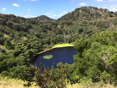 Ballarat Heritage Services
Photograph - Colour, Volcanic Crater at Tower Hill, 2017, 2017
Tower Hill is a volcanic formation believed to have erupted about 32,000 years ago. Its formation is known as a "nested maar" and it is the largest example of its type in Victoria. During formation, molten lava pushed its way up through the Earth’s crust and encountered a layer of water-bearing rock. Violent explosions followed creating a shallow crater which later filled with water to form the lake. Further eruptions occurred in the centre of this crater, creating the islands and cone shaped hills. In 1892 Tower Hill became Victoria’s first National Park. In 1961, Tower Hill became a State Game Reserve under the then Fisheries and Wildlife Department and a major re-vegetation program began. (https://www.towerhill.org.au/index.php/about-reserve/history, accessed 23 December 2019)Colour photographs of a lake in a volcanic crater at Tower Hill, Victoria. volcano, crater, lake, tower hill -
 Ballarat Heritage Services
Photograph - Colour photograph, Tower Hill, 2022, 24/12/2022
Tower Hill is a volcanic formation believed to have erupted about 32,000 years ago. Its formation is known as a "nested maar" and it is the largest example of its type in Victoria. During formation, molten lava pushed its way up through the Earth’s crust and encountered a layer of water-bearing rock. Violent explosions followed creating a shallow crater which later filled with water to form the lake. Further eruptions occurred in the centre of this crater, creating the islands and cone shaped hills. In 1892 Tower Hill became Victoria’s first National Park. In 1961, Tower Hill became a State Game Reserve under the then Fisheries and Wildlife Department and a major re-vegetation program began. (https://www.towerhill.org.au/index.php/about-reserve/history, accessed 23 December 2019)Panaramic view of Tower Hill, Victoria.tower hill, volcano, crater -
 Greensborough Historical Society
Map, Melbourne and Metropolitan Board of Works. Survey Division, MMBW, Yarra 2500 / 12.21. Watsonia North, 1979_02
Melbourne and Metropolitan Board of Works. Yarra 2500 [base map]. 12-22, Parish of Keelbundora 2856, Municipality of Diamond Valley 257. Shows street names, easement sizes, lot numbers, lodged plan numbers, names of prominent features, contour values, creek or river names. Watsonia Railway Station and environs. Prominent streets: Grimshaw Street, William Street and Macorna Street. Includes former Institute of Social Welfare (now Loyola College) Lines Reserve and Binnak Park.MMBW Map in 1:2500 [scale] series. Cream parchment with green tape reinforcing on edges and punched holes on left edge.mmbw, melbourne and metropolitan board of works, shire of diamond valley, watsonia - maps, bundoora - maps -
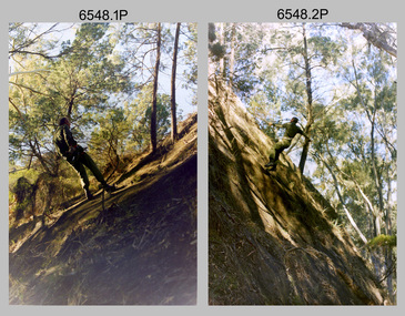 Bendigo Military Museum
Photograph - 4th Field Survey Squadron Adventurous Training, Wilpena pound, Flinders Ranges, SA, 1987
This is a set of 14 photographs of a 4th Field Survey Squadron undergoing an abseiling activity, as part of adventurous training held at Mount Remarkable National Park, South Australia in May 1987. It is evident the training focussed on teamwork, leadership, abseiling, rock climbing, field craft and living off the land survival skills. Elements from units of the Army Reserve also participated in the training. Refer to items 6546.42P and 6547.40P for additional photographs taken during the adventurous training exercise.This is a set of 14 photographs of 4th Field Survey Squadron personnel undergoing an abseiling activity, as part of 4th Field Survey Squadron adventurous training held at Mount Remarkable National Park of South Australia in May 1987. The colour photographs are on 35mm negative film and are part of the Army Survey Regiment’s Collection. The photographs were scanned at 96 dpi. .1) - Photo, colour, 1987. Abseiling activities, SSM WO1 Bill Griggs. .2) to .14) - Photo, colour, 1987. Abseiling activities, unidentified soldier..1P to .14P – There are no personnel identified. ‘1987 ADV TRAINING’ annotated on negatives sleeve.royal australian survey corps, rasvy, 4 fd svy sqn -
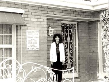 Glen Eira Historical Society
Document - Animals
This file contains 2 items: 1/A black, white and green brochure titled ‘Leash Free Parks and Reserves’ concerning leashing regulations, conditions for non-leashing, summaries of legislation and penalties for owners of dogs, written by the City of Glen Eira. It includes six illustrations and a map of Glen Eira which labels all leash free parks as well as a depiction of all the train stations in the area. 2/A collection of 37 black and white photographs which have all appeared in Caulfield Contact at some time. These include photographs of the ‘Caulfield Veterinary Clinic, North Road Ormond dated 1982, Animal Control officer Reg Dixon dated 1982, draught horses pulling a horse drawn cart dated 1988 and general animals. Photographs unknown.allnutt park, murrumbeena park, veterinary clinics, professionals, veterinarians, kirschner jane s., north rd. ormond, dixon reg, animal control officer, horses, racehorses, racecourses, draught horses, bailey reserve, sporting grounds, bentleigh/hodgson reserve, boyd park, neerim road, caulfield park, caulfield race course, duncan mackinnon park, ee gunn reserve, glen huntly park, joyce park, king george v1 memorial reserve, lords park, marara road, marlborough street reserve, moorleigh, victory park, princes park, packer park, animal enclosures, domestic animals, dogs, horse drawn vehicles, cattle, birds, animals, trains, caulfield contact -
Hume City Civic Collection
Book, Saltwater River History Trails
This book which was printed in 1984 gives not only the geology of the area but also the history of the various areas that Jacksons Creek and the Saltwater River now known as the Maribyrnong River pass through. There are many drawings and photos accompanying the information relating to the various areas and buildings researched in this book. From Sunbury to Williamstown some of the names and places mentioned include John Aitken, George Evans, William J.T. Clarke, Ben Eadie, Rupertswood, Goonawarra Vineyard, Organ Pipes, Glenara, Walter Clark, Keilor, Overnewton, Avondale Heights, Solomons ford, Riverview Tea Gardens, Anglers Hotel, Aberfeldie Park, Humes Pipe Works, Powder Magazine, Maribyrnong, Munitions factories, Footscray Park, Flemington, Footscray, Yarraville, Newport, Williamstown, Commonwealth reserve, the blue stone lighthouse. A small cream/olive green colour covered printed book of 74 pages. The front cover shows part of a pen and wash drawing of a homestead. It has the name of the book and the author Hugh Anderson printed at the top of the cover and Sunbury to the Sea printed at the bottom. There are many drawings and photos included in the book.SALTWATER RIVER/HISTORY TRAILS/HUGH ANDERSON/Sunbury to the Seasaltwater river, maribyrnong river, jacksons creek, anderson hugh, sunbury, keilor, organ pipes national park, solomons ford, riverview tea gardens, humes pipe works, powder magazine, footscray, yarraville, newport, williamstown -
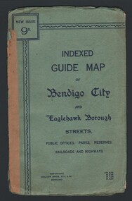 Bendigo Historical Society Inc.
Map - INDEXED GUIDE MAP OF BENDIGO CITY & EAGLEHAWK BOROUGH, Early to mid 1920's
Map. Indexed Guide Map of Bendigo City & Eaglehawk Borough. Folded map contained within blue booklet. Booklet is light blue printed with dark blue ink. Copyright Bolton Bros. Pty. Ltd. Bendigo. Printed on front. Map shows the location of Sailors Gully, Peg Leg Gully, California Gully, Long Gully, Eaglehawk Creek, Bendigo Creek, Ironbark Creek. Shows location of Showgrounds between Park St, Baxter Street, Barnard St and Bridge Lane. Shows location of Golden Square Railway Station between Panton St and Allingham St. Shows what is now known as Creek St. Nth & Sth as Clark St Nth & Sth. Also shows Tramway Terminus along Carpenter St and Golden Square Tram Terminus on High St, Golden Square. Map has a street index and an index for Public Offices, Parks and Reserves.map, bendigo, township, indexed guide map of bendigo city and eaglehawk borough -
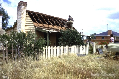
 Eltham District Historical Society Inc
Photograph, Main Road, Eltham South, near Eltham Park, flooded by the Diamond Creek, 30 Nov. 1934
Near Eltham Park (now known as Eltham Lower Park), floodwaters from the Diamond Creek cut off the Main road into Eltham at Bremner’s Flats (present day Wingrove Park). In the distance, left of centre, is Mr. Montieth's Ford Wagonette stranded in the floodwater near Wingrove Cottage. “On the Lower Eltham Reserve the water was nearly five feet deep across the reserve and over a mile along the road. All the week-end shops are surrounded. For over 40 years flood waters have not reached this unprecedented level.” - Advertiser, Friday November 30, 1934, p7 "Whilst we were at the shop a "tidal" wave occured . There used to be a Mr. Monteith who ran a Model T Ford bus from the Eltham Railway Station down the main street. The bus would hold seven, six seated in the back, 3 aside a seventh standing on the step on the middle of the back hanging on to two small hand rails. The bus was caught by the flood and was abandoned not far from our shop in the paddocks towards the Higher Elementary School. It was there for days and after the flood waters receded, Mr. Monteith, after removing all the mud and debris gave the engine one turn with the handle and it started first time! So the story goes! " (Doug Orford Reminiscences, 2004) The 1934 flood of the Diamond Creek and Yarra River is the highest recorded flooding in the district and set the standard for the current planning flood plain level.Black and white photograph showing the floodwater from Diamond Creek across Main Road in 1934. Left of centre shows Mr. Montieth's Ford Wagonette in the floodwater in the distancefloods, main road, eltham south, diamond creek (creek), wingrove cottage, wingrove park, bus services, bremner's flat, eltham park, ford wagonette, mr. montieth, floodwater, reminscences -
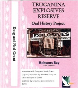 Truganina Explosives Reserve Preservation Society Inc (TERPS)
Digitised Oral History – Truganina Explosives Reserve - Tape 1 Doug and Noel Grant, 2018
The interviews were recorded in 2000 by Bronwen Gray and Alan Young for the production of Unreserved, Stories from Truganina Explosives Reserve, animated stories from past residents, workers and interested people of the Reserve (subject to copyright 2004). Doug and Noel Grant’s Grandfather, Don Grant, was officer in charge of Truganina Explosives Reserve from 1910-1930. On his retirement, his son, William (known as Bill) took over the position until 1956. Along with their two older brothers and younger sister, Doug and Noel Grant grew up, first in the assistant manager’s weatherboard cottage and then in the brick house which was set aside for the officer in charge, until they married and moved into their own homes in their early 1920s. On returning from the second world war, Noel Grant worked as a magazine assistant of explosives on the site from 1946, When the site had closed down in 1962 he worked as an inspector of explosives at the Explosives Branch in Melbourne until he retired in 1985. During that time Noel was asked to move back on site, meaning that three generations of Grants have lived on the site during the twentieth century. Doug Grant worked for ICI/Nobel in head office in 1940 and their older brother Alan worked at the Nobel Explosive Company in Deer Park from 1937. After returning from the Second World War, Alan bought a transport business that had once had the licence to cart explosives in and around the state. They discuss their memories of the living at Truganina Explosives Reserve and the workings of the Reserve, including the names of men who worked there, ships which carried the explosives and life in and around Altona. A primary source of information on memories of the Truganina Explosives Reserve and Altona,VictoriaDigital copy of original cassette recorded in 2000 and digitised in 2018hobsons bay, altona, galvanised iron fence, picket fence, golf course, altona school, margaret grant, bill grant, explosives magazine, lighters, joe hyde, alex grant, pines scout camp, maribynong river, 1896, inspector of explosives, pier, point wilson, werribee sewerage farm, george grant, lighterman, huia, argonaut, pirie, alma doepel, merton street altona, horse, jessie grant, jean grant, sandal, kilmartin, lewis, currie, todd, robinson, balwyn -
 The Beechworth Burke Museum
Photograph, c1960
The photograph depicts a view across the water at Lake Sambell. The image dates from approximately 1960. The present day park and reserve occupies the site of the former Rocky Mountain Mining Company, an open-cut sluice mine that began operations in the mid-Nineteenth Century and operated until the early 1900s, through the peak of Victoria’s Gold Rush. It was converted into a park and leisure area in the 1920s. Lake Sambell was formally opened to the public on Friday 5th October 1928 and was opened by the Victorian Government’s Minister of Lands, Mr Bailey, as part of initiatives to boost the economies and development of country towns. The lake was named after Mr L.H. Sambell, a shire engineer and secretary of the Forward Beechworth Committee who was involved in promoting the transformation of the mining site and promoting plantation forestry and tourism as alternative industries. £300 to begin the process was provided by Mr J. McConvill, a former resident of Beechworth, who is remembered in a street name adjacent to the lake. Residents of Beechworth have worked to raise funds to improve the Lake Sambell reserve several times, such as efforts in the 1930s and 1940s to raise the banks several feet to deepen the water for swimming purposes. Fundraising campaigns include the ‘Ugly Man’ competition conducted on behalf of the Wallace Park-Lake Sambell Development Scheme. The latter competition was run by the Fire Brigade Bend’s team as part of a larger competition called the ‘Mile of Pennies’; it was won by Mr Len Knight of Beechworth’s Commercial Hotel. The ‘Mile of Pennies’ was conducted at a Carnival held on New Year’s Eve, 1947. It was proposed by the Beechworth and District Progress Association. As well as improving swimming facilities, funds were raised to install a caravan park facility near the lake. Funds were also donated by commercial entities, such as £250 received from Zwar Bros. Pty Ltd. The photograph is significant as it shows the level of development of Beechworth in the early to mid-Twentieth Century. Sepia rectangular photograph printed on matte photographic paperObverse: nil. Reverse: 3470 / Velox (paper mark)beechworth, beechworth lake, lake sambell, lake, beechworth and district progress association, forward beechworth committee, ugly man, mile of pennies, wallace park lake sambell development scheme, wallace park-lake sambell development scheme, zwar bros, zwar, l.h. sambell, j. mcconvill, minister of lands, commercial hotel, len knight, rocky mountain mining company, rocky mountain mining co, gold rush, redevelopment, transformation, community fundraising -
 The Beechworth Burke Museum
Photograph, c1960
The photographs in this set depict views across the water at Lake Sambell. The images date from approximately 1960. The present day park and reserve occupies the site of the former Rocky Mountain Mining Company, an open-cut sluice mine that began operations in the mid-19th Century and operated until the early 1900s, through the peak of Victoria’s Gold Rush. It was converted into a park and leisure area in the 1920s. Lake Sambell was formally opened to the public on Friday 5th October 1928 and was opened by the Victorian Government’s Minister of Lands, Mr Bailey, as part of initiatives to boost the economies and development of country towns. The lake was named after Mr L.H. Sambell, a shire engineer and secretary of the Forward Beechworth Committee who was involved in promoting the transformation of the mining site and promoting plantation forestry and tourism as alternative industries. £300 to begin the process was provided by Mr J. McConvill, a former resident of Beechworth, who is remembered in a street name adjacent to the lake. Residents of Beechworth have worked to raise funds to improve the Lake Sambell reserve several times, such as efforts in the 1930s and 1940s to raise the banks several feet to deepen the water for swimming purposes. Fundraising campaigns include the ‘Ugly Man’ competition conducted on behalf of the Wallace Park-Lake Sambell Development Scheme. The latter competition was run by the Fire Brigade Bend’s team as part of a larger competition called the ‘Mile of Pennies’; it was won by Mr Len Knight of Beechworth’s Commercial Hotel. The ‘Mile of Pennies’ was conducted at a Carnival held on New Year’s Eve, 1947. It was proposed by the Beechworth and District Progress Association. As well as improving swimming facilities, funds were raised to install a caravan park facility near the lake. Funds were also donated by commercial entities, such as £250 received from Zwar Bros. Pty Ltd.The photographs are significant as they show the level of development in Beechworth in the middle of the Twentieth Century. Four sepia and black and white rectangular photographs printed on matte photographic paper. 3469.1: Obverse: nil Reverse: 3469-1 3469.2: Obverse: nil Reverse: 3469-2 3469.3: Obverse: nil Reverse: 3469-3 3469.4: Obverse: nil Reverse: 3469-4beechworth, beechworth lake, lake sambell, lake, beechworth and district progress association, forward beechworth committee, ugly man, mile of pennies, wallace park lake sambell development scheme, wallace park-lake sambell development scheme, zwar bros, zwar, l.h. sambell, j. mcconvill, minister of lands, commercial hotel, len knight, rocky mountain mining company, rocky mountain mining co, gold rush, redevelopment, transformation, community fundraising -
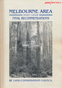 Eltham District Historical Society Inc
Book, Land Conservation Council, Melbourne Area, District 2 Review: Final Recommendations, 1994
Notices showing the boundary of the area of the review and advising that an investigation was to be carried out were published in the Victoria Government Gazette and in local and other Victorian newspapers in May 1987. A descriptive resources report was published in August 1991. Council received 1,425 submissions and letters following publication of the descriptive report. The Council considered these submissions and published proposed recommendations in April 1993. A further 1,993 submissions were received in response to the proposed recommendations. The Council published its final recommendations in July 1994. A change to legislation in 1989 enabled the LCC to make recommendations for public land within a ‘town’, though cities and rural cities remained excluded from the definition of public land. Timber resources and water quality and yield from timbered catchment areas remained significant issues in Melbourne’s catchments. Recommendations for the Yarra Ranges National Park were based around the closed Melbourne water catchments and adjoining state forest. A recommended Phillip Island State Park based around the penguin reserve was ultimately implemented as the Phillip Island Nature Park.Shire of Nillumbik DPE/Enviro -
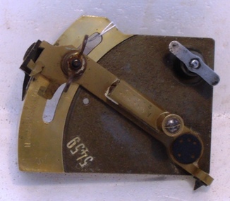 8th/13th Victorian Mounted Rifles Regimental Collection
Weapon - Gun sight, 1916 circa
This gun sight was brought home from WWI (1914-1918) by members of the 13th Battery 5th Field Artillery Brigade (Albury Battery) as a souvenir of its action in the first battle of Bullecourt April 1917. On one occasion during the battle the Battery was surrounded by a German counter attack. They dragged their guns out of the gun pits and continued firing to the flanks and rear and supported the Australian counter penetration attack which restored the situation. After the war a recreational reserve in Albury NSW was named Noreuil Park after the French village near where the action occurred.A rare object with significant connection to Albury NSW and its citizen soldiers who served with the AIF in WWI (1914-1918). The engraving gives it close association with the recreational park in Albury named after the French village of Noreuil and honouring the soldiers who fought there with great courage. Range drum portion of the sighting mechanism from an 18 Pounder field gun made of brass and other metals. The object is engraved with the word NOREUIL and the date 2.4.17.Serial No 5459; and NOREUIL 2.4.17gun sight, noreuil, albury, 13th battery -
 Melton City Libraries
Photograph, Ned Toohey's house, McKenzie Street, 1970
Cottage of Edward Toohey (died 1898) a Shire contractor and road maker. Ned, his son worked with Frederick Myers building many of the bluestone roads in the Shire of Melton. In the background is the brick house built for Martha Myers in 1967. Martha and husband Frederick (born 1877 in Melton) resided in the Myers (Miers) house on Western Highway beside the gully near Reserve road. Frederick lived there for 86 years. The house was built in 1867 by Henri and Ann nee Dowling Myers. Demolished 1968. Martha Myers house was demolished in 2011 to become a car park. Mary and Jack Tolhurst removing roof of Ned Tooheys house (site of Senior Citizens ).local identities, misc. -
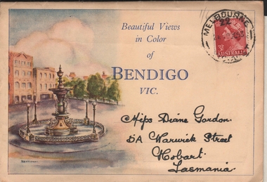 Bendigo Historical Society Inc.
Postcard - VIEWS OF BENDIGO - FOLD OUT PHOTOS IN FOLDER
Sepia coloured folder, enclosing photos of Bendigo. On front 'Beautiful Views in Color of Bendigo Vic.' Photo of Alexandra Fountain on LH side. 3 1/2d stamp on top RH corner. Folder addressed to Miss Diane Gordon 5A Warwick Street, Hobart, Tasmania. Colour photos include : Alexandra Fountain, The City Hall, The Botanic Gardens, Hargreaves Street, The Conservatory Gardens, Rosalind Park, Pall Mall, The Upper Reserve Lake and The Conservatory Gardens. Photos appear to be from the 1940's. Enclosed letter states that the donor's grandfather 'mailed them me during his visit to your city in what appears to be 1953. Diane Palmer'Valentine Publishing Co Pty Ltdbendigo, tourism, post card folder -
 Eltham District Historical Society Inc
Photograph - Digital Photograph, Marguerite Marshall, Eltham Lower Park, 20 April 2008
Originally a race course, the park has brought the community together with a variety of activities. Published: Nillumbik Now and Then / Marguerite Marshall 2008; photographs Alan King with Marguerite Marshall.; p45 Once used for horse racing, which attracted visitors from Melbourne, the Eltham Lower Park has brought the community together with a wide range of activities. Horse riding is now enjoyed as a recreation in the park as are other sports. The park also includes the Diamond Valley Railway miniature trains and a sanctuary for the rare and vulnerable Eltham Copper Butterfly. Eltham Lower Park, with other parks, forms an almost continuous green band from Eltham’s centre, along the Diamond Creek to the Yarra River.1 Before European settlement the Wurundjeri people met on this land, particularly at the junction of the Diamond Creek with the Yarra River, which they called Birr-arung. This is commemorated by the sculpture, Not just a Pretty Place by Aleks Danko, winner of the 2000 Nillumbik Art in Public Places Award. The first European to settle here was probably Henry Foley, who in 1841 used it as part of his pastoral run. Foley sold his leasehold to Joseph Wilson in 1845, who soon after sold it to Frederick Falkiner. During the 1840s the future park was part of a government square mile (2.6 sqkm) reserve, north of the Yarra, within the Parish of Nillumbik, later named Eltham. Soon the land was used for horse racing after nearby residents cleared ten acres (4ha) in the early 1850s. A three-quarter of a mile (1.2km) race secured the winner the £10 Publican’s Prize. In response to popular demand, the newly formed Eltham District Road Board petitioned the Surveyor General of the Colony of Victoria, in 1856, for 36 acres (14.6ha) of crown land for a racecourse and recreation. By 1858 the Eltham races had become an institution. ‘Many skirmishes occurred and the way home was paved with temptation, with sly-grog for sale.3 In the early 1870s, two jockeys were sons of the police officer in charge of the Eltham Police Station, Miles S Lyons. Another ten acres (4ha) was added to the area in 1866 and 12 acres (4.8ha) – Hohnes Hill – in 1870. In 1866, two acres (0.8ha) on the creek banks became an animal pound with William Walsh the pound keeper in 1870, but this was later incorporated into the park. By 1877 the area was called a public park but horse racing and training continued into the 1920s. In the mid-1900s trotters were trained on a circuit road. In 1953 the Eltham Pony Club was established and used a cross-country course on Hohnes Hill. From the mid 1950s the club held the Eltham Easter Fair at the park, later to include a procession along Main Road from the town centre to the park. The park also attracted picnic parties and campers from the inner suburbs as did Wingrove Park, and businesses catering for visitors, sprang up on the opposite side of Main Road. Bus-loads of school children visited the park for Gould League bird days in the 1960s. In 1979 the Eltham Shire Council bought Lenister Farm, linking the park with the Yarra River. The Lenister Farm wetland includes a bird hide, viewing platform and interpretive signs.5 Pioneer Henry Stooke, later Road Board chairman, bought the 11 acres (4.5ha) - later to become Lenister Farm - from the Crown in 1862. Stooke never lived on this site and the two houses at Lenister Farm were built in the 20th century. Since its formation in 1871, the Council has controlled this crown land, which it named Eltham Park. But in the 1920s Eltham Council bought land near the town centre for a park, which it named Eltham Central Park. To avoid confusion the Council renamed Eltham Park, Eltham Lower Park. Since 2004 the Yarra footbridge has linked the park with the Yarra Valley Metropolitan Park and the Main Yarra Trail.This collection of almost 130 photos about places and people within the Shire of Nillumbik, an urban and rural municipality in Melbourne's north, contributes to an understanding of the history of the Shire. Published in 2008 immediately prior to the Black Saturday bushfires of February 7, 2009, it documents sites that were impacted, and in some cases destroyed by the fires. It includes photographs taken especially for the publication, creating a unique time capsule representing the Shire in the early 21st century. It remains the most recent comprehenesive publication devoted to the Shire's history connecting local residents to the past. nillumbik now and then (marshall-king) collection, eltham lower park, eltham park