Showing 1550 items matching " streetscape"
-
 City of Kingston
Photograph - Black and white, c. 1930
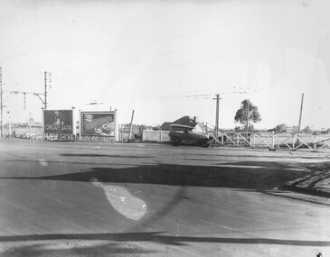
This image is part of a larger collection of images from the Public Transport Corporation displaying train stations and streetscapes in what is now the City of Kingston.The Nepean Highway is a major highway running through the City of Kingston. This image is one of many that depicts its importance to the local community as it undergoes many changes over time.Black and white photograph of the level crossing at Neapean Highway Moorabbin. Photograph is a slightly side view, with a blurred image of a car approaching the level crossing. The gates are closed. To the left of the image is a pair of billboards. The billboard on the left is promoting Creamoata, a New Zealand brand of oats, and the billboard on the right is promoting Kraft cheese.White round sticker on reverse with black printed text: 147 Handwritten in red ink on reverse: 100% Blue ink stamped on reverse: COPYRIGHT / Public Transport Corporation / For re-ordering photographs / Please quote negative No ADV 1030 / Enquiries C/- PTC Photographic Unit / Telephone switchboard 619 111moorabbin, level crossing, railway crossing, cars, advertising, nepean highway -
 City of Kingston
Photograph - Black and white, c. 1920
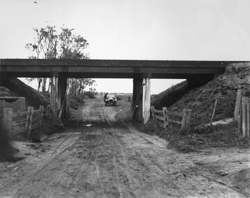
This image is part of a larger collection of images from the Public Transport Corporation displaying train stations and streetscapes in what is now the City of Kingston.While the focus of this image is the train line running overhead, the unsealed nature of the road speaks to the progression of suburban development during the 1920s.Black and white image of an unsealed underpass at Patterson Road, looking west. A car has stopped on the road in the distance and man is standing on the duckboard leaning into the car.Round white sticker on reverse with black printed text: 177 Handwritten in red ink: 60% Blue ink stamped on reverse: COPYRIGHT / Public Transport Corporation / For re-ordering photographs / Please quote negative No ADV 300 / Enquiries C/- PTC Photographic Unit / Telephone switchboard 619 111patterson road, railway, trains, cars, unsealed roads -
 City of Kingston
Photograph - Black and white, Public Transport Corporation, c. 1960
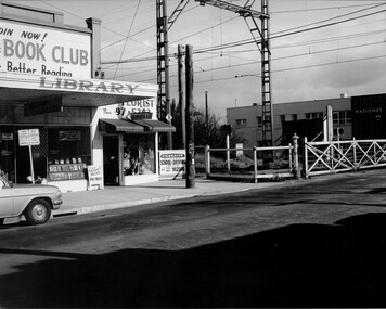
This image is part of a larger collection of images from the Public Transport Corporation displaying train stations and streetscapes in what is now the City of Kingston.The development of the railway was crucial to the ongoing development of the area. Community life sprung up around the railway line which is evident in the proximity of shopping and leisure.Black and white photograph of railway gates at Centre Road, Bentleigh.Black printed text on a small, round, white sticker on reverse: 227 Handwritten in red ink on reverse: 50% Black typed text on a strip of white paper stuck on reverse: Gates Centre Road Bentleigh / mid 1960 / $50 reproduction fee applies Blue ink stamped on reverse: COPYRIGHT / Public Transport Corporation / For re-ordering photographs / Please quote negative No H 3407 / Enquiries C/- PTC Photographic Unit / Telephone switchboard 619 1111bentleigh, railway crossing, trains, suburbs, shopping strip -
 Stawell Historical Society Inc
Photograph, A Brick House Mrs. McClure Scallan Street
Scallan St - Mrs McClureColour photograph showing a red brick house, with tiled roof and with red brick fence with painted top. The house is hidden by treet and plants. Town hall to the left of house.streetscape -
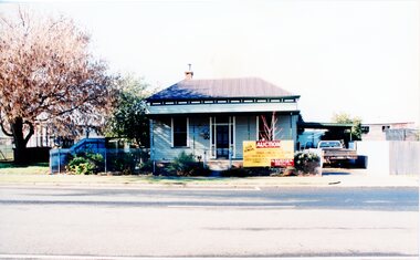 Stawell Historical Society Inc
Photograph, House Removal. Victoria Street Rob Holloway, July 1996
7103 - House with auction removal sign. -1 The view across the road to central park -2 View from the side showing seedling house and Stawell Bowling club -3 Showing the house on the truck looking towards the cab of the truck. -4 Looking back towards the house on the truck -5 The house on the truck just before turning a corner6 colour photographs showing the parks and gardens superintendents house streetscape -
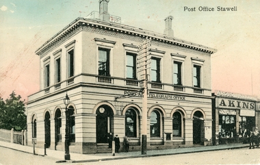 Stawell Historical Society Inc
Postcard, Stawell Post Office, c1900's
Shows Gas Lamp on corner and Telegraph Pole and wires.Stawell Post Office and Telegraph Office. Hand Coloured Post Card. Printed in Germany. Akins shop visible at Right. Printed in Germanystreetscape -
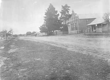 Stawell Historical Society Inc
Photograph, Main Street of Great Western 1920's
Taken at Great WesternShowing Great Western Hall and Harris House looking North. Shop in distance.streetscape -
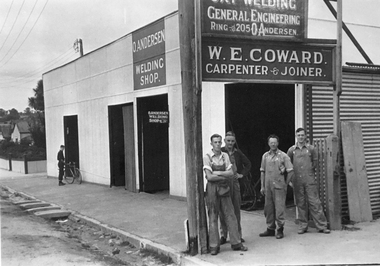 Stawell Historical Society Inc
Photograph, W.E. Coward Carpenter & Joiner Business
B/W Photograph of W.E. Coward Carpenter & Joiner shop with O. Anderson Welding Shop next door - Jack & Cliff Earle & Pop & Fred Coward 1935-1936 - Scotland Place. Young man in background with a pushbike. streetscape -
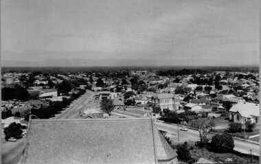 Stawell Historical Society Inc
Photograph, Lower Main Street looking West from the Town Hall clock tower 1965
View from the Clock Tower looking West down Main Street (1965)streetscape -
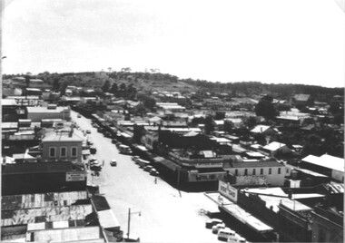 Stawell Historical Society Inc
Photograph, Lower Main Street looking East from the Town Hall clock tower 1965
View from the Clock Tower looking East up Main Street (1965)streetscape -
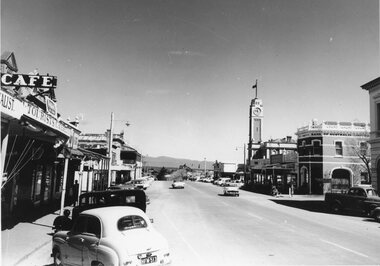 Stawell Historical Society Inc
Photograph, Stawell lower Main Street looking towards Grampians 1960's
B/W 1960's Main Street, Town Clock, bank of Australia, Café and Grampians Mountains in background. streetscape -
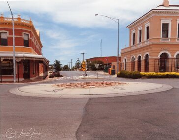 Stawell Historical Society Inc
Photograph - Pizza Roundabout with stenciled Runners; looking up Wimmera Street, Carol Ann Jones, Pizza Roundabout Cr. Main & Wimmera Streets 26th January 2020, 26/1/2020
Roundabout removed on 28th January 2020 by councilRoundabout showing Chemist and Post Officestreetscape -
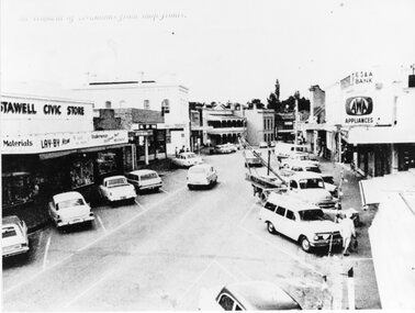 Stawell Historical Society Inc
Photograph, Upper Main Street Removal of Verandahs, 1960's
Stawell Civic Store, Senghpa's, Commercial Hotel, Oriental Bank/Bank of Australasia, ES & A Bank Upper Main Street Taken from higher up with cars in Main Street looking eastThe removal of verandahs from shop frontsstreetscape -
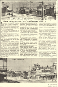 Bendigo Historical Society Inc.
Newspaper - LONG GULLY HISTORY GROUP COLLECTION: LONG GULLY - BENDIGO
BHS CollectionPhotocopy of a newspaper page two titled Long Gully, Bendigo Where things seem to just 'continue on'. At the top of the page is a sketched streetscape of Long Gully with buildings and a poppet legs along the street, tram tracks going around a corner and some people on the street. At the bottom of the page is a streetscape of Eaglehawk with buildings along the street, tram tracks and electrical poles in the centre of the road.. Written at the top of the page is Approx 1936 and at the bottom of the page is A Crossley Long Gully. The article mentions what it was like in the early years and late refers to biblical references.bendigo, history, long gully history group, the long gully history group - long gully - bendigo, nell gynne, hercules, deborah, new chum, tyson's reef, dead horse gully, pennyweight gully, golden gully, poverty gully, poor man's gully, job's gully, methodist chapel, the shamrock, bulls head, old house at home, five lions -
 Glen Eira Historical Society
Document - LEMPRIERE AVENUE
1/A newspaper cutting from The Argus 12/07/1927 (a print-out of same from Trove), praising the virtues of demolishing former mansion ‘Rozelle’ and erecting a ‘score’ of pretty modern villas from Balaclava Road directly into Green Meadows Gardens, a public reserve. Article describes modernity of homes in great details and the streetscape vistas (1 photo included) including road and pathways. 2/A Caulfield St Kilda Leader, dated 25/08/1993, article with Caulfield residents George and Edna McKaige wanting a planning amendment ‘with teeth’ to protect their Lempriere Ave streetscape. Andrew Ward, Heritage Architect, identified Lempriere Ave as one of Caulfield’s significant areas, because of its Interwar streetscape.east st kilda, ‘rozelle’ mansions, balaclava, land subdivision, balaclava road, georgian style, spanish mission style, orrong road, greenmeadows gardens, lempriere avenue, leadlight, mckaige george, power and telegraph lines, triple-fronted style, interwar streetscape, mckaige edna, ward andrew, caulfield council, elsternwick, welsh heather (councillor), councillors, akehurst jeff, caulfield heritage watch, spencer david, johnson john dr., ‘kilwinning’, george h., peterson william mrs., ‘melby’, ‘springfield’, rose-watt miss, ‘rozelle’, ‘cressy house’, meadow street, smith wallace m., heron herbert l., ‘goathland’, ‘melbe’, wright james, marsh malcolm reginald, house names, melby avenue, springfield avenue, goathlands street, kilwinning court, heritage studies, town planning -
 Charlton Golden Grains Museum Inc
Photograph, Cricket Club Hotel, High St Charlton c.1987, c.1987
Cricket Club Hotel c. 1987. Established 1875, rebuilt as two storey building in 1935. Photo part of the Shire of Charlton streetscape series 1987Colour photograph looking east down High St. Two storey, red brick Cricket Club Hotel on RH side of photo. Red car and white ute parked on the other side of the street. Red and white school crossing posts in garden bed on RH side.cricket club hotel, high st charlton, charlton, business, industry -
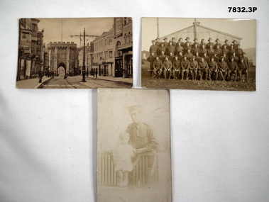 Bendigo Military Museum
Postcard - POSTCARD, PHOTOGRAPHIC
Postcards of day often held actual photos on front side. Re collection of "John Arthur Remington Alexander" No. 2237, AFC, AIF. Refer Cat 7820 for his service details.1. Black and white postcard photo of the streetscape of "The Bargate, Southampton". On the back is a message from "Andy" to Jack (presumably J.A.R. Alexander). 2. Formal picture of rows of serviceman in uniform in front of some buildings. Postcard space on back is empty. 3. 1. Letter to Jack from Andy. 2. Nil. 3. Says "Love to Daddy from Jack" "Baby held pen to sign above".postcards, ww1, john arthur remington alexander -
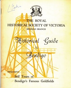 Bendigo Historical Society Inc.
Book - HISTORICAL GUIDE TO BENDIGO, INCLUDES SELF TOURS OF BENDIGO'S FAMOUS GOLDFIELDS, 1968
Historical Guide to Bendigo. Contains Self Tours of Bendigo's Famous Goldfields. Also contained within are photos of Trams, Building, Streetscapes, and Mines. Produced by the Bendigo Branch of The Royal Historical Society of Victoria, which was compiled from material supplied by members.Produced by the Bendigo Branch of The Royal Historical Society of Victoriabendigo, history, city history. the goldfields. -
 Buninyong & District Historical Society
Photograph - Original B/W Photograph, Former Whyke's Grocer building, Warrenheip St, Buninyong, 18 September 1993
Original building was established by Whyke's family Grocery, built in 1860s. Stripped to apricot brickwork. Verandah removed. Situated East Side of Warrenheip St between Eyre St and Forest St, Buninyong. Building much altered and used as a restaurant in 1970s. Fell into disrepair. Revival took place but not restoration. 1990s under threat of demolition if not conforming to council safety requirements. Building has since been renovated as a pizza restaurant (2023). Vacant lots have since been built on.Established by a prominent local family, an example of a mid 19th century shop. Black and white photo of former Whykes Grocer, 1860's. Streetscape photo of former Whykes Grocer brick building. Power pole with Warrenheip St sign. 3 other shopfronts visible, street trees and vacant land between shops.buninyong, whykes, grocery, building, street scape, warrenheip st -
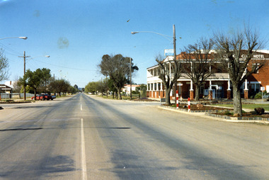
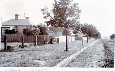 Sunbury Family History and Heritage Society Inc.
Photograph - Evans Street, Sunbury, c1900s
The photograph shows a picture of Evans Street Sunbury taken from the T intersection at Macedon Street and looking south. When the photograph was taken it was one of Sunbury's main residential areas. Since the 1980s the houses in the image have been demolished and replaced with commercial development. Over the years Evans Street has undergone much change from being a residential strip to being the main commercial hub in Sunbury.A sepia photograph with a white border across the bottom and in post card format of a streetscape with a row of trees growing along the footpath and a number of weatherboard Victorian style double fronted cottages. Both the roadway and footpath are not surfaced and the gutter is lined with stone pavers.EVANS STREETevans street -
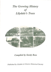 Ringwood and District Historical Society
Book, The Growing History of Lilydale's Trees, Circa 2010
Soft cover book by Sandy Ross - Lilydale & District Historical Society. Year by year summary of tree planting activities and ceremonies in Lilydale (Victoria) from 1897 to 1920. Includes several black and white photographs of township's streetscapes and Arbor Day celebrations. -
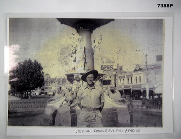 Bendigo Military Museum
Photograph - PHOTOGRAPH, WW2, C. WW2 (ORIGINAL PHOTOGRAPH)
Item in the collection re Vivian BULLEN, refer Cat No 7386 for his AIF & RAAF service details.PHOTOCOPY OF AN ORIGINAL PHOTOGRAPH. PHOTOGRAPH - BLACK AND WHITE ON PHOTOGRAPHIC PAPER WHICH HAS BEEN LAMINATED. Depicts "VIVIAN DONALD BULLEN", Bendigo - Soldier in uniform and slouch hat standing in front of a fountain with streetscape of buildings in the background. Handwritten information below photograph.Below photograph - handwritten, black ink. "VIVIAN DONALD BULLEN: BENDIGO"photograhs, ww2, army, bendigo, vivian donald bullen -
 Charlton Golden Grains Museum Inc
Photograph, Pollard, Jenny, East end of High St Charlton, south side 1989, c.1989
K.V. CHARLTON rebuilt after fire in 1976 by R. Lowe. Sold to John Sutton. Photograph is part of Jenny Pollard's streetscape series taken in 1989 for Charlton Shire.Colour photograph showing K.V, Charlton service station. Three men in front on the footpath. Two petrol bowsers on RH side of service station. Post Office on right of service station. Signage on building says MASSEY FERGUSON K.V. CHARLTON HOLDENk.v. charlton service station, r. lowe, john sutton, charlton, business, industry, post office -
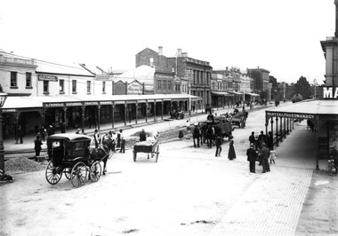 Ballarat Tramway Museum
Photograph - Geelong Streetscape
Photograph of a Geelong streetscape with tram tracks under construction. Shows range of businesses at the time. Pedestrians are shown, along with a dray and horses and other horse drawn vehicles of the period.Black and white print on paperPhotograph missingtram track construction, geelong streetscape -
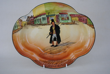 Anglesea and District Historical Society
Plate, Royal Doulton, Charles Dickens Plate, Estimated 1930's (1932+)
Mainly orange/yellow plate with figure "Barkis" the coach-driver holding a whip. Streetscape in background. Known as The Barkis Arnhem Tray. D3175 dated July 1930. Shape No. 8279. (ref: Nicholnack art in pottery - nicholnack.com.au/dickens-ware/dickens-plates-trays.html).Maker's mark: could be " L. Young". Back: Royal Doulton Dickens Ware - copyright / Made in England / with picture of man with beard. Also stamped with Lion on a crown - dated -1932+ / Shape no. 734 stamped before glazing. "Barkis". charles dickens plate -
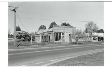
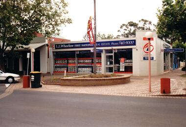 Hume City Civic Collection
Photograph, Prior to 1995
This corner was occupied in the past by Lloyds Chemist shop which was a weatherboard structure. The photograph was taken prior to 1995 when 8 digit telephone numbers were introduced throughout the Metropolitan area.A coloured photograph of the streetscape of the SW corner of Evans and Brook Street. The main shop is occupied by L. J Whorlow, Real Estate Agents. A white car is parked on the LHS of the photograph and a garbage bin is placed next to a concrete bollard by the kerb and on the brick paved footpath.real estate agents, shopping centres, whorlow, l. j., lloyd, l. m., first national real estate, evans street, brook street, george evans collection -
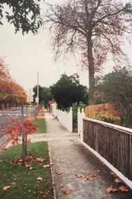
 Kew Historical Society Inc
Photograph - Carson Street, Kew, 1993
A series of five photographs of streetscapes in Kew in 1993, of which this is one, focus on footpaths and gutters, so while the provenance is uncertain, it is presumed that they were created in the office of City Engineer in the City of Kew.Colour positive print of Carson Street, which runs between Studley Park Road and Findon Crescent, dating from 1993carson street -- kew (vic.) -
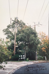 Kew Historical Society Inc
Photograph - Corner of Hodgson and Young Streets, Kew, 1993
A series of five photographs of streetscapes in Kew in 1993, of which this is one, focus on footpaths and gutters, so while the provenance is uncertain, it is presumed that they were created in the office of City Engineer in the City of Kew.Colour positive print of the corner of Hodgson and Young Streets, Kew, dating from 1993."Corner Hodgson & Young Streets"hodgson street -- kew (vic.), young street -- kew (vic.) -
 Kew Historical Society Inc
Photograph - Carson Street, Kew, 1993
A series of five photographs of streetscapes in Kew in 1993, of which this is one, focus on footpaths and gutters, so while the provenance is uncertain, it is presumed that they were created in the office of City Engineer in the City of Kew.Colour positive print of Carson Street, Kew, dating from 1993.carson street -- kew (vic.) -
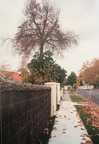
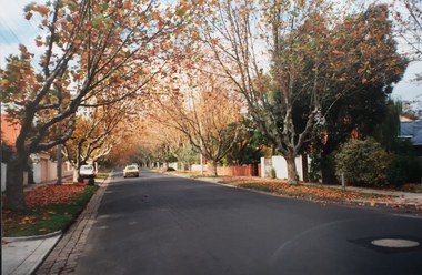 Kew Historical Society Inc
Photograph - Street view, Kew, 1993
A series of five photographs of streetscapes in Kew in 1993, of which this is one, focus on footpaths and gutters, so while the provenance is uncertain, it is presumed that they were created in the office of City Engineer in the City of Kew.Colour positive print of a street in Kew, dating from 1993.streets -- kew (vic.)