Showing 845 items
matching surveyor
-
 Clunes Museum
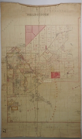
Plan - PLANS CLUNES CARAVAN PARK, NO. 1 - SHIRE OF TALBOT & CLUNES. IAN MANSLEY, SHIRE ENGINEER NO. 2 - LEO MCMAHON & ASSOCIATES PTY. LTD. LICENSED SURVEYORS & ENGINEERS, 31 LYONS ST. NTH. BALLARAT, 1976
NO. 1 PLAN - CLUNES CARAVAN PARK ENGINEER - IAN MANLEY NO. 2 PLAN - SECTION 15 TOWNSHIP OF CLUNES, COUNTY OF TALBOT, BY LEO MCMAHON AND ASSOCIATES, LICENSED SURVEYORS AND CIVIL ENGINEERSplans, caravan park, ian manley, plan section 15 -
 Kew Historical Society Inc
Plan - Subdivision Plan, Argyle Road, Heather Grove, Victor Avenue, Kew, c.1937
The Kew Historical Society's map collection includes a substantial number of real estate subdivision plans, mainly of Kew but also of surrounding suburbs in Melbourne. Most of the subdivision plans date from the 1920s and 1930s when the districts old homes and local farmland were being split up to accommodate residential growth in the postwar period. These early plans were assembled by a local firm, Jas R Mather & McMillan, which had an office in Cotham Road. Many of the plans, and sometimes photos, were annotated by the agents.Subdivision plans are historically important documents used as evidence for the growth of suburbs in Australia. They frequently provide information about when the land was sold as well as evidence relating to surveyors and real estate and financial agents. The numerous subdivision plans in the Kew Historical Society's collection represent working documents, ranging from the initial sketches made in planning a subdivision to printed plans on which auctioneers or agents listed the prices for which individual lots were sold. In a number of cases, the reverse of a subdivision plan in the collection includes a photograph of a house that was also for sale by the agent. These photographs provide significant heritage information relating house design and decoration, fencing and household gardens.The photograph may also be aesthetically significant depending on the importance of the photographic atelier.Undated blue subdivision plan in Kew of 14 lots facing Argyle Road, Heather Grove and Victor Road. The Plan identifies Tuxen & Miller as the surveyors. [Formerly catalogued as MAP.0059]subdivision plans - kew, argyle road - kew, heather grove - kew, victor avenue - kew -
Port Melbourne Historical & Preservation Society
Map - Foreshore, Sandridge, 1840
Bromide of surveyor's sketch of the foreshore of Sandridge (Liardet's Beach), 1840, showing Pier and Marine hotels with respective jetties. Originals with Lands Department, Melbourne. (possibly the work of William Wedge DARKE?) '5' on backbusiness and traders - hotels, piers and wharves, william wedge darke -
 Bendigo Historical Society Inc.
Map - NEILBOROUGH, 21/01/1875
Map: Parish of Neilborough, County of Bendigo. Hand draughted Parish plan. Resurveyed by Mr Assistant-Surveyor G Black. Drawn by W A Taylor. Map dated 21/1/1875.map, bendigo, parish plan, neilborough, g. black, w.a. taylor -
 Federation University Historical Collection
Map - Plan, E.J. Dunn, Bungal County of Grant Parish Plan
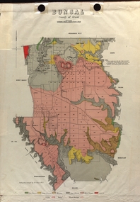
E.J. Dunn was the surveyor of this parish plan.Colour geological plan of Bungal in the County of Grant, Victoria. The areas circled in red ar craters.plan, bungal, bungeltap, black horse co. egerton, egerton, mount egerton, sister rose shaft, south learmonth co, kerrit bareet, bungaeeltap, yaloak, eastern moorabool river, corong, bungal station preemptive right, lal lal, western moorabool river, moorabool rover, borhoneychurck, mount egerton battery, bungal creek -
Tatura Irrigation & Wartime Camps Museum
Book, Practical Surveying, 1901
Used by surveyors and as an educational text bookDark green linen like covered cardboard technical book. Gold writing on spinepractical surveying, usill gw, craven w, tatura, surveying, terrestrial, books, technical -
 National Vietnam Veterans Museum (NVVM)
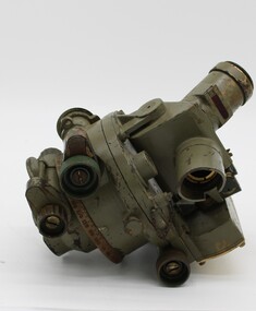
Equipment - Dumpy level in case
Standard equipment as used by Australian servicemen during the Vietnam conflict. This type of level was first issued for use in WW2.Khaki metal instrument with lens-viewfinder and numbers on circular range finding wheels. Object is stored in a khaki metal box with canvas carry straps. Attachments inside the box prevent it from slipping. Red label attached to strap says the object cannot be repaired.place/date/McBc = GdBg/ McB6 = GdBg/ BuBl COR. Inside box: scientific instruments MFGI and Repair Co. Pty Ltd/ 573 Burwood Road, Hawthorn 815527surveying tool, dumpy level, survey, surveyor, level -
 Whitehorse Historical Society Inc.
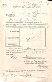
Document - Report, Section 31 Land Act 1869, 01/06/1872
Land application by Frank Ainger, referred to District Surveyor. Report by Mounted Constable Douglas with description of proposed use of land. Map of area. The area is on the corner of Whitehorse Road and Doncaster East Road.ainger, frank, douglas (mounted constable), assistant commissioner of lands and survey, whitehorse road, mitcham, doncaster east road, land settlement -
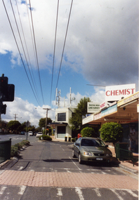 Whitehorse Historical Society Inc.
Photograph, Mitcham North Shopping Centre, 2006
Coloured Photo of Mitcham North Shopping Centre (opposite Park Road) looking south. Communications towers situated on roof of a security service building. Land surveyor and chemist on right (west side ).mitcham north shopping centre, shops, shopping centre -
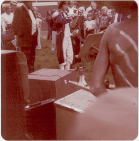 Kew Historical Society Inc
Photograph - Historic re-enactment during the Festival of Kew, 1978
At the 1978 Festival of Kew, a number of organisations, including the City of Kew, the Kew Historical Society, Trinity Boys Grammar School and local Girl Guides participated in a re-enactment of the expedition of the party of Charles Grimes in surveying the Yarra River as far as Kew in February 1803. The location for the event was Yarra Bend Park near the Studley Park Boat House. The event was organised by the Kew Historical Society. The re-enactment was captured by a number of amateur photographers as well as by a photographer from the local Progress Press.Local communities select events to commemorate according to their shared history and values. Commemorations of colonial exploration were popular with local historical groups such as the Kew Historical Society in the twentieth century. In re-enacting events such as the Grimes survey of the Yarra, students from a local school were encouraged to take on specific roles, including play-acting individuals involved in the survey party as well as members of the local Wurundjeri People. The photographs, taken by amateur and professional photographers, represent a period in time when the dominant values were those shared by the descendants of European settlers in Victoria. Original colour photographic positive of the [unhistoric] report by a Trinity Grammar School student, dressed in costume as the surveyor Charles Grimes, reporting to the then Mayor of Kew, Cr Noel Whiting. Wurundjeri warriors are in the foreground. .Annotated on reverse: "GRIMES REPORTING TO MAYOR"kew historical society, trinity grammar school, kew girl guides, city of kew, yarra river, charles grimes, collins expedition, wurundjeri people, yarra bend park, colonial surveys, historic re-enactments, festival of kew, kew festival -
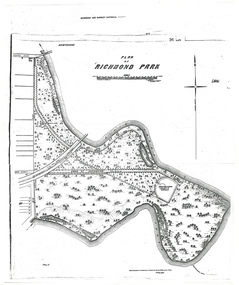 University of Melbourne, Burnley Campus Archives
Plan - Photocopy, A.L. Martin et al, Plan of Richmond Park, 1872
Layout of Richmond Park showing railway line, Pic-Nic Station, Swan Street extension and Horticultural Society's Garden. 3 photocopies of plan surveyed and drawn by A.L. Martin, Authorised Surveyor. Photolithographed at Dept of Lands and Survey by J. Noone 6th Sept. 1872. Showing the entire park and the Horticultural Society's Garden.richmond, parks, a.l. martin -
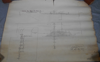
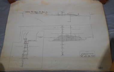 Bendigo Historical Society Inc.
Administrative record - Central Red, White and Blue Mine map
Draftsman's drawing of Central Red, White and Blue Mine Map. Printed by Troedel & Cooper Pty Ltd. Mr. H. Cumby, Surveyor Forms part of the Margaret Roberts Collection of mining records.bendigo, margaret roberts, gold, map, mine, central red white & blue -
Port Melbourne Historical & Preservation Society
Plan - Drainage Improvements, Ross Street, Port Melbourne, Borough of Port Melbourne, 3 Nov 1892
Plan of Ross Street drainage improvement diversion drain, 1892.Signatures of J. J. Bartlett (Mayor), A. V. Heath (Borough Surveyor), W. Harrison, Laurence Brady (Contractor)engineering - canals and drainage, james john bartlett, arthur victor heath, town clerks, w harrison, laurence brady -
![Map, Plan of Subdivision of Crown Portion 23 & parts 24-25, Parish of Korkuperrimul [1900s?]](/media/collectors/5e461d8021ea67224c82f2a1/items/675fe058304668462205d4fb/item-media/675fe0ef304668462205d7d6/item-fit-380x285.jpg) Bacchus Marsh & District Historical Society
Bacchus Marsh & District Historical SocietyMap, Plan of Subdivision of Crown Portion 23 & parts 24-25, Parish of Korkuperrimul [1900s?]
The Parish of Korkuperrimul includes a significant section of the township of Bacchus Marsh and extends in western and northern directions from the township area. The date of the subdivision indicated on this plan has not been established. The engineer's stamp on the drawing shows the firm of Muntz and Muntz who were operating under that name in the early part of the 20th century.A single page paper map showing 20 blocks of land for sale in the Parish of Korkuperrimul. Scale 100 feet to 1 inch. The map is pasted into a bound volume containing 76 maps or plans in total. High resolution digital image stored on BMDHS computer network. Stamped: 'Muntz & Muntz Civil Engineers, Architects & Surveyors, Trustees Chambers ?? Cor Collins Street and Bank Placeland sales bacchus marsh, bacchus marsh victoria maps, land sales korkuperrimul parish -
Tatura Irrigation & Wartime Camps Museum
Book, Surveying, 1898
Used by surveyors, schools and colleges as a text bookLight brown linen like covered cardboard technical book used in schools and colleges. 17th Ediction, revised and extended, numerous illustrationssurveying, baker t, dixon fe, craven w, tatura, terrestrial -
 Bendigo Historical Society Inc.
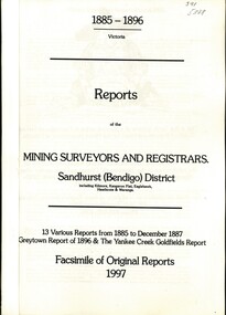
Book - REPORTS OF THE MINING SURVEYORS AND REGISTRARS 1885 - 1896, 1997
Reports of the Mining Surveyors and Registrars. Sandhurst (Bendigo) District. 13 various Reports from 1885 to December 1887 Greytown Report of 1896 and the Yankee Creek Goldfields Report. Facsimile of Original Reports 1997.goldfields, mining reports -
 Bendigo Historical Society Inc.
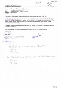
Document - REQUEST FOR INFORMATION ON ANCESTORS: JOHN REED AND THOMAS PRITCHARD
Request 2012 for information on ancestors - John Reed (surveyor, health inspector) and Thomas Pritchard (founder of Bendigo and United Brewery). Children : - William Reed and Mary Louisa Pritchard. Reply with details of photographs of people.cottage, miners -
 Bendigo Historical Society Inc.
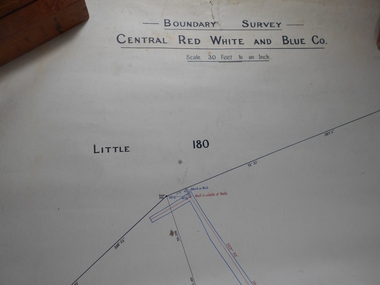
Administrative record - Central Red White and Blue Mine Map
Draftsman's drawing Boundary Survey of Central Red White and Blue Co Map. Handwritten signature of Garnet G Buich, Licensed Mining Surveyor Forms part of the Margaret Roberts Collection of mining records.bendigo, margaret roberts, gold, map, mine, central red white and blue -
 Queenscliffe Maritime Museum
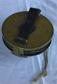
Instrument - Surveying Hydrographic measuring Instrument
Survey tape used by P.J. Larkin, government surveyorInstrument owned and used by a government marine surveyor named P. J. Larkin who worked in Melbourne and Geelong in the 1930s.Survey tape in leather pouch about 100 feet long and housed on brass reel.Purton and Littlejohn's patent Wellington 1663surveying instrument, hydrography, larkin jp -
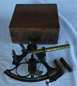 Queenscliffe Maritime Museum
Instrument - Sextant in wooden box
Sextant used by J P Larken, Government Marine SurveyorThe sextant has been the primary position fixing tool of the marine surveyor for 200 years used to measure angles between beacons or points for hydrographic surveys. A sextant in its own wooden box.On inside box lid; 'A. E. Parson surveying and scientific instrument maker, Queen Street, Melbournesextant, jp larken, marine surveyor -
 Bendigo Historical Society Inc.
Administrative record - Central Red White and Blue Company Mine map
Draftsman's drawing of Central Red, White and Blue Mine. Printed by Troedel & Cooper Pty Ltd, Surveyor Mr. H. Cumby, Bendigo April 1913 Forms part of the Margaret Roberts Collection of mining records.bendigo, margaret roberts, gold, central red white and blue gold mine, map -
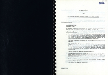 Federation University Historical Collection
Report, SMB: Review Survey of Buildings and Grounds, July 1985, 1985
Report of the detailed review of The School of Mines and Industries Ballarat Limited undertaken by Alexander & Alexander in 1985. Previous reports were done in 1982 and 1983. The report covers all areas of the school - buildings and grounds. Some sections/buildings are still being completed. Report contains written evaluation, maps/diagrams and photographs.Spiral bound book - dark blue cover. 15 pages of written information plus 3 pages of photographs.Gold lettering on from cover "Alexander & Alexander" Signature "J W Elliott" on page 10 (Loss Control Surveyorballarat school of mines and industries, survey, alexander and alexander, j w elliott, maps, photographs -
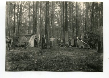 Orbost & District Historical Society
black and white photograph, April 18 1897
This photograph shows a group of surveyors at Treasury Camp - April 18 1897.This is a pictorial record of a late 19th century bush camp set up by surveyors involved in determining land settlement in East Gippsland.A black / white photograph of a group of men and a horse standing around a campfire. The camp is in a clearing and tents are set up with some bark coverings.surveyors- land-settlement -
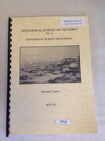 Stawell Historical Society Inc
Book, Norman Taylor, Geological Survey of Victoria No3, Geological Survey of Stawell, 1875-1876
Geological Survey of Stawell 1875/76 by Norman Taylor, Geological SurveyorYellow Card Front and Rear Cover with B/W Picture of mining scene. with black Plastic spineGeological Survey of Victoria No.3 Geological Survey of Stawell Norman Taylor 1875/76stawell mining -
Ringwood and District Historical Society
Collection of talks, Pullin, E. et al, Text of talks by E. Pullin on Clement Hodgkinson etc 1984, c.1980s
3 bundles of foolscap pages, typewritten record of talks(3) 1. by E. Pullin to the Maroondah Auxiliary 1984, 2. about the Surveyor, Clement Hodgkinson, 3. miscellaneous. +Additional Keywords: Pullin, E. / Hodgkinson, Clement -
Federation University Historical Collection
Plan, Ballaarat Common, 1898
Plan showing Ballaarat Common, Police Reserve, Industrial School Reserve, Cattleyards Railway, Powder Magazine, Scarsdale and Ballarat Railway, Ararat and Ballarat Railway and Mr Comries House. Robert Davidson was the surveyor. WGS 84ballaarat common, police reserve, industrial school reserve, cattleyards railway, powder magazine, scarsdale and ballarat railway, ararat and ballarat railway, comrie, ballarat common, robert davidson, ballarat industrial school -
 Frankston RSL Sub Branch
Case, Transit
A wooden, protective transit case to suit a plane table compass as used by surveyors and artillery crew. These compasses were used by artillery units of the Australian Military Forces during World War 2. Refer 00330 and 00330.1 -
 Ringwood and District Historical Society
Document - Copy of Lands Department Field Notes - Parish of Ringwood, Victoria, Field Notes 55114 Survey of Allotment by J.D. Sherwood in 1955
5618b Foolscap size photocopy of survey map with handwritten notations. References include Railway (Reserve), Education Department, A-B Datum 117degrees20', Bedford Road, Certification by J.D. Sherwood Licensed Surveyor 23/11/1955. -
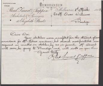 Bendigo Historical Society Inc.
Document - W.D.MASON COLLECTION: MEMORANDUM, 5 March 1903
Document, W.D.Mason Collection, Memorandum from Reed, Smart & Tappin, Architects & Surveyors 44 Elizabeth Street, Melbourne. Your sketches were accepted for the stained glass windows for Mr. Holmes's residence, but some modifications are required.business, retail, w d mason -
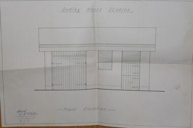 Bendigo Historical Society Inc.
Document - DUDLEY HOUSE COLLECTION: DUDLEY HOUSE STABLES
Folded front elevation document illustrating Dudley House Stables approved with signature by R H Chellew dated 18/5/77, ink stamped below signature Building Surveyor City of Bendigo. Unknown donorbendigo, house, dudley house