Showing 844 items
matching surveyors
-
 Bendigo Historical Society Inc.
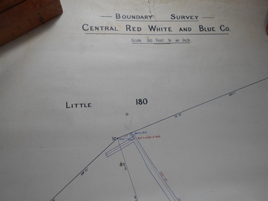
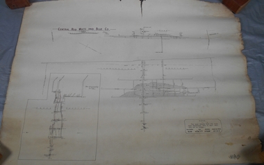
Administrative record - Central Red White and Blue Mine Map
Draftsman's drawing Boundary Survey of Central Red White and Blue Co Map. Handwritten signature of Garnet G Buich, Licensed Mining Surveyor Forms part of the Margaret Roberts Collection of mining records.bendigo, margaret roberts, gold, map, mine, central red white and blue -
 Queenscliffe Maritime Museum
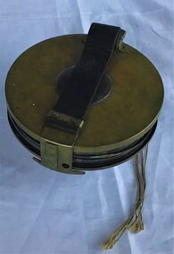
Instrument - Surveying Hydrographic measuring Instrument
Survey tape used by P.J. Larkin, government surveyorInstrument owned and used by a government marine surveyor named P. J. Larkin who worked in Melbourne and Geelong in the 1930s.Survey tape in leather pouch about 100 feet long and housed on brass reel.Purton and Littlejohn's patent Wellington 1663surveying instrument, hydrography, larkin jp -
 Kiewa Valley Historical Society
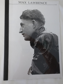
Booklet - Max Lawrence, Max Lawrence - Sue Field interviewed Max for this story
Max Lawrence worked as a surveyor on the Kiewa Hydro Electric SchemeBooklet of 4 pages with Max's photo on the front and with a black plastic spine and black back cover.max lawrence, kiewa hydro electric scheme, surveyor -
 Queenscliffe Maritime Museum
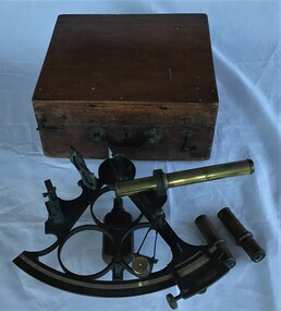
Instrument - Sextant in wooden box
Sextant used by J P Larken, Government Marine SurveyorThe sextant has been the primary position fixing tool of the marine surveyor for 200 years used to measure angles between beacons or points for hydrographic surveys. A sextant in its own wooden box.On inside box lid; 'A. E. Parson surveying and scientific instrument maker, Queen Street, Melbournesextant, jp larken, marine surveyor -
 Bendigo Historical Society Inc.
Administrative record - Central Red White and Blue Company Mine map
Draftsman's drawing of Central Red, White and Blue Mine. Printed by Troedel & Cooper Pty Ltd, Surveyor Mr. H. Cumby, Bendigo April 1913 Forms part of the Margaret Roberts Collection of mining records.bendigo, margaret roberts, gold, central red white and blue gold mine, map -
 Federation University Historical Collection
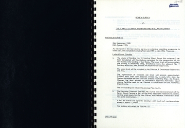
Report, SMB: Review Survey of Buildings and Grounds, July 1985, 1985
Report of the detailed review of The School of Mines and Industries Ballarat Limited undertaken by Alexander & Alexander in 1985. Previous reports were done in 1982 and 1983. The report covers all areas of the school - buildings and grounds. Some sections/buildings are still being completed. Report contains written evaluation, maps/diagrams and photographs.Spiral bound book - dark blue cover. 15 pages of written information plus 3 pages of photographs.Gold lettering on from cover "Alexander & Alexander" Signature "J W Elliott" on page 10 (Loss Control Surveyorballarat school of mines and industries, survey, alexander and alexander, j w elliott, maps, photographs -
 Orbost & District Historical Society
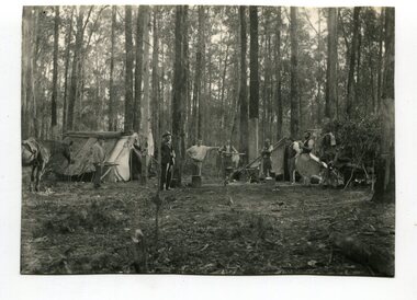
black and white photograph, April 18 1897
This photograph shows a group of surveyors at Treasury Camp - April 18 1897.This is a pictorial record of a late 19th century bush camp set up by surveyors involved in determining land settlement in East Gippsland.A black / white photograph of a group of men and a horse standing around a campfire. The camp is in a clearing and tents are set up with some bark coverings.surveyors- land-settlement -
 Stawell Historical Society Inc
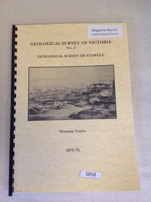
Book, Norman Taylor, Geological Survey of Victoria No3, Geological Survey of Stawell, 1875-1876
Geological Survey of Stawell 1875/76 by Norman Taylor, Geological SurveyorYellow Card Front and Rear Cover with B/W Picture of mining scene. with black Plastic spineGeological Survey of Victoria No.3 Geological Survey of Stawell Norman Taylor 1875/76stawell mining -
 Ringwood and District Historical Society
Collection of talks, Pullin, E. et al, Text of talks by E. Pullin on Clement Hodgkinson etc 1984, c.1980s
3 bundles of foolscap pages, typewritten record of talks(3) 1. by E. Pullin to the Maroondah Auxiliary 1984, 2. about the Surveyor, Clement Hodgkinson, 3. miscellaneous. +Additional Keywords: Pullin, E. / Hodgkinson, Clement -
Federation University Historical Collection
Plan, Ballaarat Common, 1898
Plan showing Ballaarat Common, Police Reserve, Industrial School Reserve, Cattleyards Railway, Powder Magazine, Scarsdale and Ballarat Railway, Ararat and Ballarat Railway and Mr Comries House. Robert Davidson was the surveyor. WGS 84ballaarat common, police reserve, industrial school reserve, cattleyards railway, powder magazine, scarsdale and ballarat railway, ararat and ballarat railway, comrie, ballarat common, robert davidson, ballarat industrial school -
 Frankston RSL Sub Branch
Case, Transit
A wooden, protective transit case to suit a plane table compass as used by surveyors and artillery crew. These compasses were used by artillery units of the Australian Military Forces during World War 2. Refer 00330 and 00330.1 -
 Ringwood and District Historical Society
Document - Copy of Lands Department Field Notes - Parish of Ringwood, Victoria, Field Notes 55114 Survey of Allotment by J.D. Sherwood in 1955
5618b Foolscap size photocopy of survey map with handwritten notations. References include Railway (Reserve), Education Department, A-B Datum 117degrees20', Bedford Road, Certification by J.D. Sherwood Licensed Surveyor 23/11/1955. -
 Bendigo Historical Society Inc.
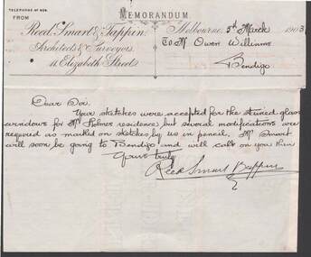
Document - W.D.MASON COLLECTION: MEMORANDUM, 5 March 1903
Document, W.D.Mason Collection, Memorandum from Reed, Smart & Tappin, Architects & Surveyors 44 Elizabeth Street, Melbourne. Your sketches were accepted for the stained glass windows for Mr. Holmes's residence, but some modifications are required.business, retail, w d mason -
 Bendigo Historical Society Inc.
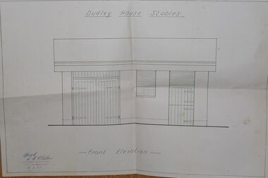
Document - DUDLEY HOUSE COLLECTION: DUDLEY HOUSE STABLES
Folded front elevation document illustrating Dudley House Stables approved with signature by R H Chellew dated 18/5/77, ink stamped below signature Building Surveyor City of Bendigo. Unknown donorbendigo, house, dudley house -
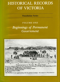 Victorian Aboriginal Corporation for Languages
Book, Pauline Jones, Historical records of Victoria : volume 1 : beginnings of permanent government, 1981
Reproductions of various transactions and reports dealing with the early government of Port Phillip, including laws, surveyors? and administrators? reports, bills, requisitions, prices, police reports, and miscellaneous other documents dealing with the early administration of Port Phillip.victorian history, port phillip, governor bourke, geelong, john batman, treaty, william lonsdale, william buckley, werribee -
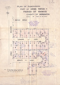 Ringwood and District Historical Society
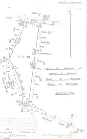
Document, Plan of Subdivision - Part of Crown Portion 7, Parish of Ringwood, County of Mornington - 1962
Map of residential allotments coloured red, with land coloured blue set apart for drainage & sewerage easements. Rubber stamped J.P. Tuohy, Licensed Surveyor, 25 Howe Street Murrumbeena, Tel. 561945, dated 38.8.1962.Map includes Maidstone Street, Norfolk Avenue, Stanhope Court and Wrights Court, Ringwood, Vic. Also includes handwritten Estate Agent sales notations. -
 Greensborough Historical Society
Poster - Planning Document, Shire of Diamond Valley et al, Subdivision Plan # 1044 - Parish of Nillumbik, County Bourke, Crown Allotment B Section 12, Eltham North, 1981-1987
Subdivision Plan # 1044 - Parish of Nillumbik, County Bourke, Crown Allotment B Section 12, Eltham North. This subdivision plan includes Weidlich Road and St Clems Street. The developer for this subdivision is Taunton Developments and the Surveyors are Fisher Cleeland Turner & Dwyer Vic, Surveyors and Engineers.An example of hard copy subdivision plans from the Greensborough area. Mainly from the Shire of Diamond Valley era (1964-1994).Plan (single sided) mounted on heavy card. Stamped and handwritten Council permissions, dates and other details. subdivision plans, shire of diamond valley, taunton developments -
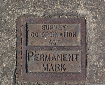 Victorian Interpretive Projects Inc.
Photograph - Colour, Ballarat Survey Permanent Mark
A survey Permanent Mark was used by surveyors to enable them to plot land accurately.A colour photograph of a metal mark in the footpath on the corner of Ballarat's Sturt Street and Doveton Street. The Permanent Mark was put in place as part of the Survey Co ordination Act ballarat, survey, surveyor, footpath, infrastructure -
 Bacchus Marsh & District Historical Society
Map, Allotments in the Village of Rowsley, Parish of Gorrocburkghap, County of Grant c.1856
Rowsley is a locality 11 kilometers south-west of Bacchus Marsh. The date of this map is uncertain. A very similar map held by the State Library of Victoria (SLV) contains slightly more information than this copy and is dated as an 1856 map. SLV reference: 'Allotments in the Village of Rowsley, Parish of Gorrocburkghap, County of Grant', by T. Nixon, Assistant Surveyor, May 1856 ; Surveyor General’s Office, July 18 1856 (lithographed by R. Meikle). (1856). Melbourne: Surveyor General’s Office. MAPS 820 BJE 1837- ROWSLEY 1856. A single page paper map. A cadastral map of the Village of Rowsley in Victoria, showing numbered land allotments. 57 allotments are shown on the map and some areas set aside as reserves. Allotments 8, and 10-16 are outlined in red ink and allotment 9 has a cross in red ink on it. The map is pasted into a bound volume containing 76 maps or plans in total. High resolution digital image stored on BMDHS computer network. rowsley victoria history, rowsley victoria maps -
Stawell Historical Society Inc
Map, Easton Johnstone, Map of Stawell Surveyed by Easton Johnstone 1872, 1872
Victoria Co Crushing Machine. St Georges Co Crushing machine. Wimmera Co Crushing Machine. Government Reservoir and Drainage. Sloan Street, Skene Street Mines. old Mine WorkingsA2 map of Stawell Reefs Area. Showing Crushing Machines & Title InfoSurveyed by Easton Johnstone Contract Surveyor. Photo-Lithographed at the Department of Lands & Survey. Melbourne By J Noone 9th May 1872mining -
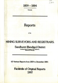 Bendigo Historical Society Inc.
Book - REPORTS OF THE MINING SURVEYORS AND REGISTRARS 1859 - 1884, 1997
Reports of the Mining Surveyors and Registrars, 1859 - 1884. Covering Sandhurst (Bendigo) district, including Kilmore, Kangaroo Flat, Eaglehawk, Heathcote, and Waranga. 63 various reports from 1859 to December 1884. Facsimile of original reports 1997.goldfields, mining reports -
 Bendigo Historical Society Inc.
Document - VICTORIA SURVEY REPORT 1859 TO 60
Four page report presented to both houses of parliament by Surveyor General CH W Ligar dated 1859-60. Object of survey to establish the best method of delineating the boundaries of new allotments in the colony. Geodetic method recommended.bendigo, history, allottment survey -
 Victorian Aboriginal Corporation for Languages
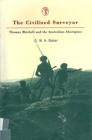
Book, D W A Baker, The civilised surveyor : Thomas Mitchell and the Australian Aborigines, 1997
Thomas Mitchell, surveyor in Sydney from 1827 at the time when Squatters were extending their runs with huge detriment to the Aboriginal population. Mitchell and his men were ambiguous in their treatment of the people. His conviction was in the superiority of the British civilisation.Maps, b&w illustrationsthomas mitchell, new south wales history, race relations, racism, colonisation -
Clunes Museum
Document - REPORTS
E J Dunn described the geology of the mining in an around Clunes and a recommendation for re-commencing mining operations in Clunes 1909.1 PHOTOCOPY OF A PAGE SHOWING RETURNS MADE BY MINING SURVEYORS AND REGISTERS TAKEN FOR THE QUARTER ENDED 31ST MARCH 1875 .2 & .3 PHOTOCOPY OF TWO PAGES OF A GEOLOGICAL SURVEY COMPLETED FOR THE GOVERNMENT (SENT IN 17/5/1909)NILlocal history, document, mining -
Lakes Entrance Historical Society
Book, Gippsland Heritage Journal No 12 June 1992, 1992
No 12 of Series contains stories of Sealers Cove, Dargo, biographical details of Edward Lees, Surveyor, Lucy Way, photographer, Leah Liddiard and Buchan Charlie, bushranger also information on early Gippsland Newspapers Photographs and maps included.settlers, bibliography, photography, periodicals -
 Orbost & District Historical Society
book, 1922
William Hunter (1893-1971), resident of Tatura and Mallacoota was a soldier, surveyor and amateur naturalist.This item is associated with William Hunter.A black covered book of astronomical observations and results handwritten on lined pages. Inside is a blotter - "Reed Bros Tomato Sauce" ; an envelope addressed to "William Hunter Esquire Survey Camp Tubbut" and three stamps.hunter-william astronomy science -
 Kew Historical Society Inc
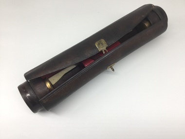
Equipment - Writing Equipment, Writing Case, 19th century, 19th century
Leather pen case, containing writing equipment, possibly used by early surveyor or draftsmanCylindrical leather case containing bottles for ink and sand, holders for pens, nibs, etc. Red leather lining. Ruler, bone-spreader, ivory and brass seal, and pen-holder included. Brass external clasps.writing equipment, writing cases -
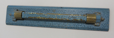 Federation University Historical Collection
Drawing Equipment, Ruler, Straight /Parallel Lines
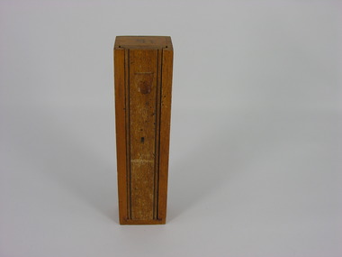
... surveyors ...Blue coated brass rule with straight edges. Mounted on grooved roller mounts. brass, ruler, engineers, architects, surveyors -
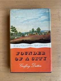 Robin Boyd Foundation
Book, Geoffrey Dutton, Founder of a City: the Life of Colonel William Light, 1960
... Surveyors ...Hardcover w/ Dust Jacketaustralian biography, south australia, surveying, surveyors, walsh st library -
 Greensborough Historical Society
Poster - Planning Document, Shire of Diamond Valley et al, Subdivision Plan # 1026 - Parish of Nillumbik, County Bourke, Crown Allotment B Section 12, Eltham North, 1981-1984
Subdivision Plan # 1026 - Parish of Nillumbik, County Bourke, Crown Allotment B Section 12, Eltham North. This subdivision plan includes Ryans Road (also known as Government Road) and St Clems Street. The developer for this subdivision is Taunton Developments and the Surveyors are Fisher Cleeland Turner & Dwyer Vic, Surveyors and Engineers.An example of hard copy subdivision plans from the Greensborough area. Mainly from the Shire of Diamond Valley era (1964-1994).Plan (single sided) mounted on heavy card. Stamped and handwritten Council permissions, dates and other details. subdivision plans, shire of diamond valley, taunton developments