Showing 331 items
matching view hill house
-
 Stawell Historical Society Inc
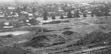
Photograph, Panorama of Stawell from Big Hill with the Stawell Water Supply Dam -- 3 Photos
Three views from Big Hill December 9th 1928 Davis Open Cut in foreground Black Range at Back. Stawell Court House with mining holes in foreground. Water Reservoir between trees. 3 Black & White photos of Stawell water supply dam taken from Big Hill.(29.11). Stawell from Big Hill Dec 9th 1928. - (29.11a) Nov 1928. L.C. Langford. - (29.11b). Stawell from Big Hill Dec 9th 1928. stawell -
 Stawell Historical Society Inc
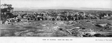
Photograph, Panorama of Stawell from Big Hill c 1930
Panorama of Stawell from Big Hill, Looking at Patrick Street. Grampians in Background Views from Big Hill 1930 showing remnants of mining. Visible Kinsella House Patrick Street, Stawell Court House, Hotel Patrick Street, Upper end of Main StreetTwo identical paper print views of Stawell from Big Hill, taken in 1930 courtesy of "The Leader". View of Stawell From Big Hill 1930 [By Courtesy of "The Leader'stawell, panorama, mining, streetscape -
 Stawell Historical Society Inc
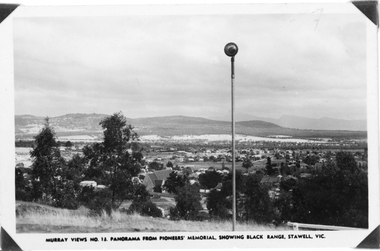
Photograph, Panorama of Stawell from Pioneer's Memorial, towards the Black Range. Murray Views No.13
Murray Views No. 13. Panorama over Stawell, looking South West. Spotlight on Pioneer's Memorial (29,5). Black Range in background, grassland on Big Hill at front of Photo. St Patrick's Church visible, Kinsella House. The larger photo 29.5a is a slightly closer view of same scene and shows the "new" school (corner Patrick & Holt Street) opened in 1934.Two similar views of Stawell. One Murray views looing south west (29.5) and the other a larger photo showing school building beside church (29.5a).Murray Views No.13. Panorama from Pioneer's Memorial, showing Black Range, Stawell, Vic. (on 29.5)stawell, panorama -
 Stawell Historical Society Inc
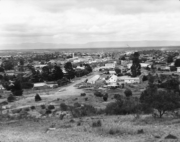
Photograph, Panorama of Stawell from Big Hill c 1960's
Panorama View of Stawell from Big Hill with Grampians in Background. c 1960 looking Down top end of Sloane Street across Fisher Street. Stawell Court House visible. Top end of Main Street Visible corner of Patrick and Main StreetBlack & White photo of Stawell from Big Hill. View showing Upper Sloan St with Fisher St crossing to the right. stawell, panorama, streetscape -
 Whitehorse Historical Society Inc.
Photograph, Eckermann's Poultry Farm, c1960
Photographs relate to the Poultry Farms that existed in Nunawading and Forest Hill in the1950s and 1960s. Photos taken in 1961-62. Poultry farmers included Messrs Boyce, Gallos, Foote,Grimsley, Greenwood and Dudley|Slides scanned as a 'tiff' at 300dpi to CD Rom and cleaned and adjusted by Ted Arrowsmith.View from Eckermann's Poultry Farm of Mrs White's house from Boyle's fence early in morning.eckermann's, eckermann frank, poultry farms, nunawading, greenwood, forest hill, canterbury road, mount pleasant road nunawading, boyles, white, bruer's -
 Whitehorse Historical Society Inc.
Photograph, Eckermann's Poultry Farm, c1960
Photographs relate to the Poultry Farms that existed in Nunawading and Forest Hill in the1950s and 1960s. Photos taken in 1961-62. Poultry farmers included Messrs Boyce, Gallos, Foote,Grimsley, Greenwood and Dudley|Slides scanned as a 'tiff' at 300dpi to CD Rom and cleaned and adjusted by Ted Arrowsmith.View from Eckermann's Poultry Farm. Poplar trees and Mrs. White's house taken from the Cow Bail.eckermann's, eckermann frank, poultry farms, nunawading, greenwood, forest hill, canterbury road, mount pleasant road nunawading, boyles, white, bruer's -
 Northern District School of Nursing. Managed by Bendigo Historical Society Inc.
Photograph - NDSN Anniversary 1975 Lister House
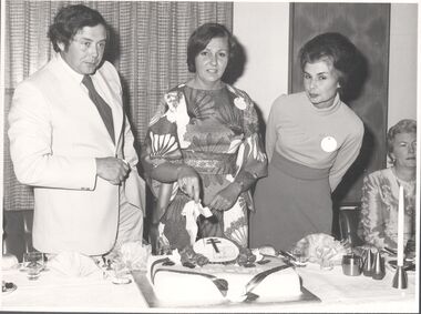
The Northern District School of Nursing opened in 1950 in to address the issues around nurse recruitment, training and education that had previously been hospital based. The residential school was to provide theoretical and in-house education and practical training over three years. The students would also receive practical hands-on training in the wards of associated hospitals. The Northern District School of Nursing operated from Lister House, Rowan Street, Bendigo. It was the first independent school of nursing in Victoria and continued until it closed in 1989.B&W photograph NDSN 25th Anniversary celebration 26th April 1975, held at A.N.A. Downtown Motel, View Street, Bendigo. NDSN 25th anniversary celebrations: Mr. S. Gerry (Dean NDSN), Miss V. Steggall (Matron Swn Hill, Graduate of NDSN) and Mrs M. Gerry (L to R). seated Mrs T. Dulling (Director of Nursing B.B.H) A.N.A. Downtown Motel, Sat. 26th April 1975. photographers stamp; Aulsebrook & Martin, 311 Williamson Street, BendigoNDSN 25th anniversary celebrations: Mr. S. Gerry (Dean NDSN), Miss V. Steggall (Matron Swn Hill, Graduate of NDSN) and Mrs M. Gerry (L to R). seated Mrs T. Dulling (Director of Nursing B.B.H) A.N.A. Downtown Motel, Sat. 26th April 1975.ndsn, nursing -
 Ballarat Heritage Services
Digital photographs, Blackpool 2016, 2016
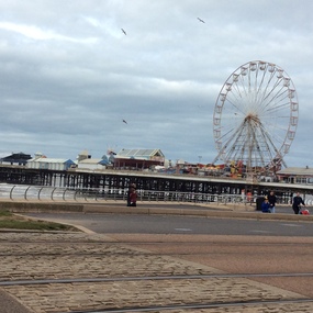
Black pool was one of the first seaside towns to experience middle and lower class visitations in the Edwardian period. The Blackpool tower is noted as an iconic landscape. "Blackpool is a seaside resort on the Irish Sea coast of England. It's known for Blackpool Pleasure Beach, an old-school amusement park with vintage wooden roller coasters. Built in 1894, the landmark Blackpool Tower houses a circus, a glass viewing platform and the Tower Ballroom, where dancers twirl to the music of a Wurlitzer organ. Blackpool Illuminations is an annual light show along the Promenade. Weather: 8 °C, Wind SE at 18 km/h, 81% Humidity Local time: Wednesday 8:44 am Postcode: FY1-FY4" wikipediaDigital images in colour -
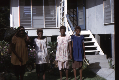 Ballarat Heritage Services
Slide, Dorothy Wickham, Papuan ladies, Papua New Guinea, 1960s
Scanned from a coloured slideView from this sidepapua new guinea, papuan, ladies, kinnane house, kinnane -
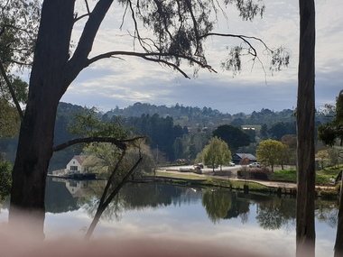 Ballarat Heritage Services
Photograph, Lake Daylesford Boathouse, 2020, 2020
Colour photographs of a view across Lake Daylesford twards the Boat House.lake daylesford, central springs, boat house -
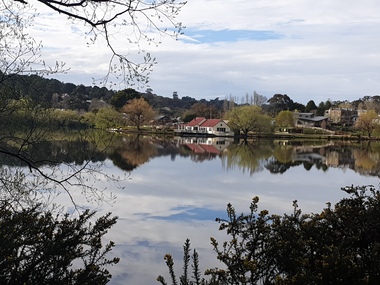 Ballarat Heritage Services
Photograph, Lake Daylesford, 2020, 2020
Colour photographs of a view across Lake Daylesford twards the Boat House.lake daylesford, central springs, boat house -
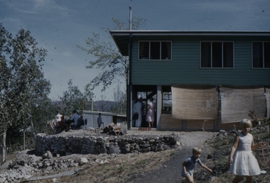 Ballarat Heritage Services
Slide, Dorothy Wickham, Uniting Church, Boroko, Papua New Guinea, 1958
Scanned from a coloured slideView from this sidepapua new guinea, papuan, house, uniting church, church, boroko -
 Ballarat Heritage Services
Photograph - Colour, Germano's, Yandoit Creek, 16/01/2016
Luigi Germano was from Asti, Italy. The home of the late Rene and Tony Saligari was built on the site of the former Yandoit Hills State School. The school was moved to the corner of Main Rd and Seventh Street, Yandoit Creek.Colour landscape view of a drystone house built at Yandoit Creek by Luigi Germano, and a weatherboard house built by Tony and Rene Saligari.luigi germano, yandoit creek, yandoit hills state school -
 City of Ballarat Libraries
Photograph, Wesleyan Church and Lecture Hall
The church and hall are located on the Dana Street hill. The shade and hot houses of Lang's Nursery can be seen in the bottom right of the picture. This sketch comes from from the Premier Album of Ballarat Views circa 1870-1880.church, hall, building, wesley church, dana street, lang's nursery, commerical, premier album of ballarat views -
 Ballarat Heritage Services
Photograph - Sepia, Bergamo House, Yandoit Creek
Photograph of the back view of Bergamo House, the home of Luigi and Eliza Gervasoni. Their Australian born son, George Gervasoni, sits on a horse in the background.yandoit, luigi gervasoni, eliza gervasoni, eliza ritzau, george gervasoni -
 Ballarat Heritage Services
Photograph - Colour, Clare Gervasoni, Villa Parma, Hepburn Springs, 2005, 12/10/2005
Parma House was bult by Italian born Fabrizio Crippa. It was restored from a burnt wreck to Villa Parma by Richard Rigby and Franchek. Walls were scraped back to the original, and burnt umber detailing added. The garden was created by Richard Rigby and Kevin Flintoff.View from the second storey window of Parma House, Main Road, Hepburn Springs.villa parma, fabrizio crippa, parma house, richard rigby, kevin flintoff, garden, hepburn springs -
 Ballarat Heritage Services
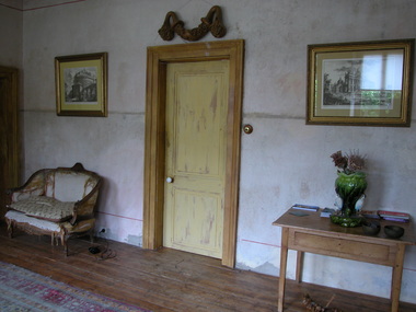
Photograph - Colour, Clare Gervasoni, Interior of Villa Parma, Hepburn Springs, 2005, 12/10/2005
Parma House was bult by Italian born Fabrizio Crippa. It was restored from a burnt wreck to Villa Parma by Richard Rigby and Franchek. Walls were scraped back to the original, and burnt umber detailing added. The garden was created by Richard Rigby and Kevin Flintoff.Interior view of the interior of Parma House, Main Road, Hepburn Springs.villa parma, fabrizio crippa, parma house, richard rigby, kevin flintoff, garden, hepburn springs, foyer -
 Ballarat Heritage Services
Photograph - Colour, Clare Gervasoni, Interior Staircase at Villa Parma, Hepburn Springs, 2005, 12/10/2005
Parma House was bult by Italian born Fabrizio Crippa. It was restored from a burnt wreck to Villa Parma by Richard Rigby and Franchek. Walls were scraped back to the original, and burnt umber detailing added. The garden was created by Richard Rigby and Kevin Flintoff.Interior view of the staircase at Parma House, Main Road, Hepburn Springs.villa parma, fabrizio crippa, parma house, richard rigby, kevin flintoff, garden, hepburn springs, foyer -
 Ballarat and District Irish Association
Photograph - Colour, Clare Gervasoni, Crossley near 'Hillside" McCartney's Lane, 2014, 04/04/2014
Before 1941 "Hillside", McCartney's Road was associated with the Carroll Family. Patrick Edmund Carroll, his wife Mary Matilda Fitzgerald, and children Kathleen, Ronald and Rosemary were the last members of the family to live at and work "Hillside". Stanislaus Kelly and his wife Margaret (nee Gorman) bought the farm from the Carroll family. The couple raised six children on the land: May, Mary, Leo, Ray (Lofty), Daniel (Tich) and Bernadette. The family grew spuds and onions on the hill and milked cows, with the little dairy located on the eastern side of the house. (information from Mary Kelly)Colour digital photographs of Crossley, Victoria, near McCartney's Lane. The house depicted is "Hillside" in McCartney's Lane. The views towards an extinct volcano is Tower Hill.crossley, hillside, carroll, tower hill, mccartney's lane -
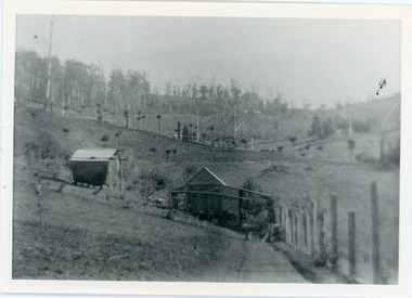 Mt Dandenong & District Historical Society Inc.
Photograph, View of the Kalorama Valley c1905
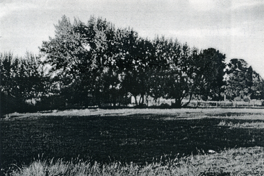
John Lundy-Clarke grew up in the Kalorama/Mt Dandenong area and later in life (1972-74) began to write a comprehensive history of the area working from an original settlement map in an effort to cover all areas. This photograph c1905 is looking up from George Barber's house 'Forest Edge' on Barbers Road. 'Forest Edge' was built c1898 and was the home of George Barber and his wife Sarah Ann (nee Richardson). The buildings in the foreground are the stables and hayshed.Black and white photograph showing two small buildings in the foreground with cleared hills behind. Handwritten decription on back by John Lundy-ClarkeA 1905 view of the Kalorama Valley towards the Gap. Barbers stables in foreground with hayshed on left. Tait’s house in centre of picture with Logans in the same fold above the hayshed. “Kalorama” is centre of Gap with Paynter’s “Iona” on its left with stables to its left. It was from one of these trees on the top left that the runaway log was cut that leaped over Barbers Road (at the top edge of the cleared land) then over Logan’s house in one bound in 1930.george barber, sarah ann barber, john lundy-clarke, forest edge -
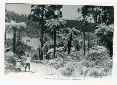 Mt Dandenong & District Historical Society Inc.
Photograph, View From Doughty's Road 1913
Mt Calvin, the homestead of Jeanie and Willie Richardson can be clearly seen in the clearing above the men in the picture. The white roof of the Barber homestead is on the right of the picture. A landslide in 1934 destroyed the tree ferned area. John Lundy-Clarke grew up in the Kalorama/Mt Dandenong area and later in life (1972-74) began to write a comprehensive history of the area working from an original settlement map in an effort to cover all areas.Black and white photograph that is a copy of a Rose series postcard titled 'The Picturesque Road to Mt. Dandenong. Vic.' It shows two men (probably Rose Series employees), one sitting and one standing at the edge of an unmade road. Large tree ferns line the roadside. Handwritten inscription on reverse by John Lundy-Clarke1913 View east from Doughty’s Road showing Jeannie Richardson’s home through the gap in the trees. A little to the right of and below centre of picture can be seen George Barber’s home with Barbers Road turning around the wagon shed that was a little up the hill from the house. The tree ferns in the picture were destroyed in the landslide of 1934. In the distance at the right can be seen F.M. Childs Homestead complex with the Richardson paddocks beyond it.mt calvin, jeanie richardson, willie richardson, george barber, landslide, tree fern -
 Mt Dandenong & District Historical Society Inc.
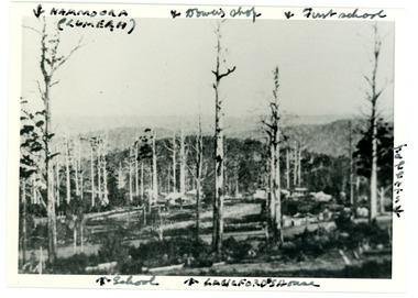
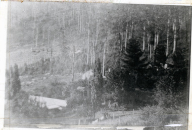
Photograph
Iconic photograph taken by Edgar Dower on Ridge Road in 1913 from an area known as Point Clear that shows the buildings of early Mt Dandenong before the CRB road went through in the 1920s.Black and white photograph with tall, dead trees in foreground and a view of hills in the distance. Buildings can be seen across the centre of the photograph. There are handwritten annotations around the border with arrows referring to areas in the photograph. Reverse of photograph has handwritten description by John Lundy-Clarke.Front from top left: Namoora (Lumeah), Dower's Shop, First school, Talent's, Langford's house, School. Reverse: 1913 view from O'Halloran's LOT 4, Section 3 on Ridge Road. Showing Lumeah (Namoora) Farndons Road (fence) School, Lowes House?, Falls Road Shop (Dowers) Langford's Falls Road (LOT 9, Section 1) Shed on Colomb's LOT 19, Sect 2 Colomb's House (Fergusons) First school Campbell's Blythes Road Lil Badenhop's P.O. In middle distance - Talent's homestead and sheds.point clear, namoora, lumeah, langford, dower, talent, colomb, ferguson, campbell, farndons road, mt dandenong school -
 Mt Dandenong & District Historical Society Inc.
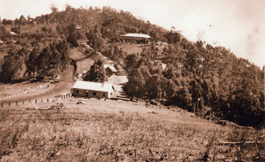
Photograph, 1920s view of Kalorama FiveWays, c1920
North view Mountjoy complex, Post Office and Store at FiveWays. Mountjoy Guest-house on hll with Jeeves Coach Service.Black and white photograph looking up hill towards guest house with two smaller buildings clearly visible in foreground and several roof tops in distance.ellis jeeves, fiveways, guest house, jeeves, mountjoy, post office, coach service -
 Mt Dandenong & District Historical Society Inc.
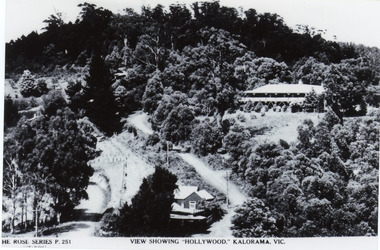
Photograph, View Showing 'Hollywood' Kalorama, Vic
Copy of Rose Series postcard #251 showing 'Mountjoy' named as 'Hollywood'. Mount Dandenong and Ridge Roads are visible at the FiveWays intersection along with the TeaRoom/Post Office. c1940Black and white photograph of a bushed setting with a building centre front and another, larger building up hill on RHS. Two unmade roads are visible with fences and telephone/power poles.The ROSE SERIES P. 251 VIEW SHOWING "HOLLYWOOD". KALORAMA, VIC.rose series, fiveways, guest house, mt dandenong road, ridge road, post office, hollywood, tea rooms, mountjoy -
 Mt Dandenong & District Historical Society Inc.
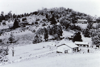
Photograph, View of Raspberry Crop and Orchard in Price Family Property
... and Mountjoy Guest House up on hill. View of Raspberry Crop and Orchard ...Wide view showing raspberry crop and orchards on Price Family property with home of Norman Jeeves in foreground and Hubert Jeeves' Motor garage to the left. Long, dark building is now gallery. Tea House/Post office right of centre and Mountjoy Guest House up on hill. fiveways, jeeves, mountjoy, orchard, tea rooms, price, crop -
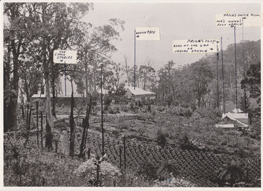 Mt Dandenong & District Historical Society Inc.
Photograph, 1908 View of the Kalorama Gap from Main Road With Labelling, 1908
Photograph with labels attached to front identifying buildings. View of the Kalorama Gap from main Road (now Ridge Road), looking across Walker's raspberry patch with Mountjoy coaching stables on the LHS and Mountjoy Guest House in centre. Price's house and shop on the RHS. This photograph has a detailed inscription on the back handwritten by John Lundy-Clarke in 1974.1908 View of the Kalorama Gap from main Road – now Ridge Road above Lot 2 of the Village Settlement. Looking across Walker’s raspberry patch with “Mountjoy” coaching stables on left. “Mountjoy” in centre. Prices house and shop on right with Hands “Beulah Tearooms” above Prices roof. On hillside beyond Hand’s is the slope now taken up by Kalorama Terrace. Walker’s well, then newly dug is in lower right hand corner below the tree fern head. Mt Kalorama is the hill top right. Track leaving Main Road left is Walker’s entrance drive.kalorama, kalorama gap, walker, beulah tea rooms, price, hand, mountjoy, mt kalorama -
 Mt Dandenong & District Historical Society Inc.
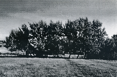
Photograph, View of valley looking south over 'Kalorama' towards falls, 1908
View taken 1908 looking south over 'Kalorama', home of Ellis and Eliza Jeeves, across the valley towards the falls.This photograph has a detailed inscription on the back handwritten by John Lundy-Clarke in 1974.View taken 1908 of valley looking south over “Kalorama” towards the falls. House right of “Kalorama” was Paynter’s “Iona” on Lot 29. Faintly below line of Barber’s Road above “Kalorama” is Logan’s house on Lot 28. House against orchard was Pimm’s later Prince’s Lot 19. Big trees on right were on Price’s Lot 18 and were between Tosari Rd and Rosemont Cres. It was FROM one of these being cut up in 1931 that the round length log weighing ½ a ton got away from the splitters and raced down the hill in bounces, one of which cleared Barber’s Rd and Logan’s house in leaping from the fence line above the road.kalorama, paynter, iona, barbers road, ellis jeeves -
 Southern Sherbrooke Historical Society Inc.
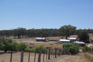
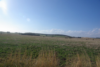
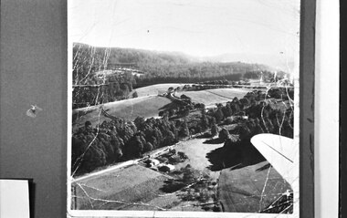
Photograph, Aerial view of Cotswold Valley
Aerial view of Cotswold Valley, Menzies Creek. B&W photos taken from light plane. Paddocks and treed areas are visible. Two houses are in the centre of the photo, presumably the Breen farmhouse on Jacksons Hill Road. The tip of the plane's left wing is also visible. -
 Ballarat Tramway Museum
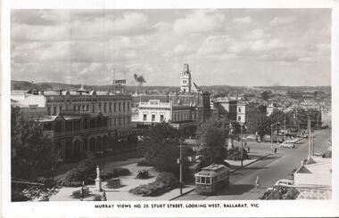
Postcard, Murray Views, Murray Views No. 29 - Sturt Street Looking West, Ballarat Vic.", c1955
Postcard - black and white - titled Murray Views No. 29 - Sturt Street Looking West, Ballarat Vic.", actually looking east from Doveton St towards Black Hill and Grenville St. Has tram 32 westbound to Gardens via Drummond St North. Divided back postcard with details of the maker on the right hand side, MV symbol and a space for a stamp. In the view are Lester House, Tunbridges, Crockers and the Post Office Tower. A Plume sign is also visible.Yields information about the appearance of Sturt St in the early 1950's, tram operations, buildings and motor vehicles.Postcard - divided back, unused Murray Viewstrams, tramways, sturt st, doveton st, tram 30 -
 Bendigo Historical Society Inc.
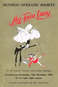
Programme - BENDIGO OPERATIC SOCIETY '' MY FAIR LADY''
Bendigo Operatic Society ''My Fair Lady'' At the Capital Theatre View Street Bendigo Commencing Wednesday 14th November 1973 for an Eight Night Season. Souvenir Programme for 50th Production. President: Mr. J. Cannon. Producer: Max Collis. Musical Director: Gwen Grose. Society Pianist: Diana Cohn. Cast in Order of Appearance: Carol McKenzie as Eliza Doolittle - Max Rule as Freddy Eynsford-Hill - Kathie Farn as Mrs. Eynsford-Hill - Ralph Watkins as Colonel Pickering - John Beaumont as Henry Higgins - Gary Burns as Bartender - John Boquest as jamie - Russell Barter as Harry - Peter Pritchard as Alfred P.Doolittle - Patricia Lyon as Mrs. Pearce - Pauline Speedy as Mrs. Hopkins - Jill James as Mrs. Higgins - David Daenke as Zoltan Karpathy.program, theatre, bendigo operatic society