Showing 6378 items
matching 2016-04
-
 Melbourne Athenaeum Archives
Theatre Flyer, Dami Im ‘Yesterday Once More’ 2016 National Tour performed at Melbourne Athenaeum Theatre on 19 November 2016, 2016
Eurovision rep 2016 placed secomcoloured flyer dami im, athenaeum theatre, yesterday once more tour -
 Melbourne Athenaeum Archives
Internet Article, The Show of the Year 2016 Presemted by the Wheeeler Centre commencing at the Athenaeum Theatre 7th of december 2016, 2016
internet promo article Printout double - sidedcasey benneto, deborah conway, wheelers centre -
National Vietnam Veterans Museum (NVVM)
Certificate, Victorian Branch VVAA Statewide Gravesite Commemorations, Sunday 21 February, 2016, Certificate of Appreciation awarded to Eric Cross
Awarded to Eric Cross for your significant contribution to the success & dignity of the Commemorations by playing the Last Post & Rouse. as above 2016 Good G Wade 2019 7/03/2019 Collected 11/07/1905 Library G Wade Victorian Branch VVAA 7/03/2019 7425 Document Documents: Folder 3 The Battle of Long Tan: Vietnamese Accounts Reviewed - What did they say?"Battle of Long Tannational vietnam veterans museum -
 Ballarat Tramway Museum
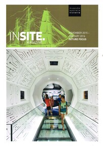
Magazine, Museums Australia, "Insite Magazine - November 2015 - January 2016", Nov. 2015
Magazine - 20 A4 pages printed in full colour on gloss white paper, centre stapled - "Insite Magazine - November 2015 - January 2016" containing an article "The Ballarat Tramway Museum Goes Solar Powered" written by Paul Mong and Warren Doubleday. Provides the background to the installation of the solar panels to the BTM Depot in Nov. 2014. Has photos of the solar panels and inverters as well as tram 28. Provides information on costs.trams, tramways, btm, solar panels, museums australia -
 Greensborough Historical Society
Booklet, Banyule City Council, Banyule Volunteer Awards 2016, 2016_
This volume lists the nominees for the 2016 Banyule Volunteer Awards. Includes information on the volunteers' work in the community. Other award nominees covered include Young Volunteer, Aboriginal and Torres Strait Islander Volunteer, Multicultural Community Volunteer, Community Volunteer, Good Neighbour and Citizen of the Year.40 pages, colour illus.banyule volunteer awards 2016 -
 Victorian Interpretive Projects Inc.
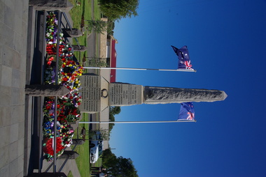
Photograph - Colour, Dennington War Memorial, 25 April 2016, 25/04/2016
Photographs of the Denington War Memorial, and wreaths left there on ANZAC Day.dennington war memorial, anzac day, wreaths, world war one -
 Ballarat Heritage Services
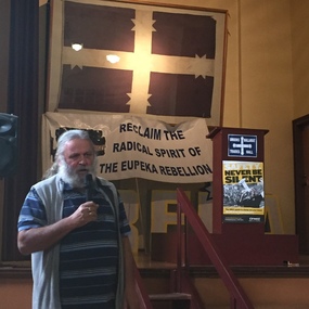
Photograph - Colour, Clare Gervasoni, Joe Toscano speaks at Ballarat Trades Hall, 2016, 04/06/2016
The Ballarat Trades Hall Eureka Flag The flag originally flew from the flagstaff of the Trades Hall Building in Camp Street Ballarat on 03 December 1942. This prompted many enquiries to teh Ballarat Courier newspapper. The Courier reported that the flag was, in fact, a replica of the origina Eureka Stockade flag. The newspaper reported: "It (seemed) very strange that the town in which Eureka made a name for Australoa and its effort to get freedom from the control for the ordinary man, did not recognise the flag that flew which the first move for freedom was fought out againt big odds." The Trdaes Hall Eureka FLag, made of cotton material, was uded in Union marches during hte 1940s. In later years it was all but forgotten, until in 1981 it was brought to the office of the ten MHR for Ballarat, John Mildren by members of the family that the flag maker boarded with in Ballarat. David Miller, who had a keenintered in the Eureka story and was electorate officer for John Mildren, became custodian of the flag for many years and presented it to the Ballarat Trades Hall for display. In 1994 the Ballarat Trdes Hall Eureka Flag traveled Australia as part of a touring Eureka collection at the time, the Secretary of the Ballarat Regiona Trades and Labour Council, Graeme Shearer said "...The Eureka Fag then, as it does not, sybolises the struggle for basic rights and democracy. On Wednesday 11th July 2001, following a ceremony to mark the refurbishment of the Galloway Monument, the Ballarat Trades Hall Eureka Flag was unveiled at a function in the Ballarat TradesHall by President of the Ballart Trades & Labour Council, Rhonda Young and Premier of Victoria, Steve Bracks. Joe Toscano speaks at Ballarat Trades Hall while standing in front of a replica Eureka Flag.joe toscano, eureka flag, ballary trades hall -
 Ballarat Heritage Services
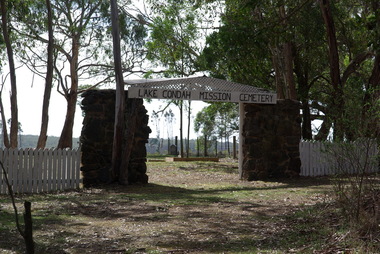
Photograph - Colour, Clare Gervasoni, Lake Condah Mission Cemetery, 2016, 17/04/2016
Colour photographs of Lake Condah Cemetery.lake condah, lake condah aboriginal mission, aborigines, cemetery -
 Ballarat Heritage Services
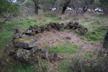
Photograph - Photograph - Colour, Aboriginal Rock Huts at Tyrendarra, 2016, 16/04/2016
The Budj Bim National Heritage Landscape - Tyrendarra Area on the Australian National Heritage List lies on the Tyrendarra lava flow between the Fitzroy River and Darlot Creek close to the township. These photographs were taken during a guided tour with Gunditjmara guide Dennis Rose. Remains of stone shelters built and used by the Gunditj Mirring people.rock shelter, aboriginal, aborigines, tyrendarra, winda mara, dennis rose, budj bim national heritage landscape, gunditjmara -
 Ballarat Heritage Services
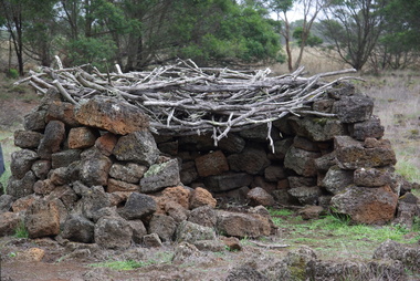
Photograph - Colour, Aboriginal Rock Hut recreations at Tyrendarra, 2016, 16/04/2016
The Budj Bim National Heritage Landscape - Tyrendarra Area on the Australian National Heritage List lies on the Tyrendarra lava flow between the Fitzroy River and Darlot Creek close to the township. The Budj Bim Cultural Landscape was ascribed on the UNESCO World Heritage List on 06 July 2019 (AEST). These photographs were taken during a guided tour with Gunditjmara guide Dennis Rose.Remains of stone shelters built and used by the Gunditj Mirring people.rock shelter, aboriginal, aborigines, tyrendarra, winda mara, rock hut, gunditjmara, unesco world heritage -
 Ballarat Heritage Services
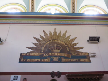
Photograph - Photograph - Colour, Interior of Clunes Town Hall, 2016, 30/04/2016
The painted interior of the Clunes Town Hall is a war memorial A number of colour photographs showing the ipainted nterior of the Clunes Town Hall, including the World War One memorial which includes a rising sun painted onto an interior wall.clunes town hall, world war one memorial, rising sun, aif, architecture, clunes -
 Ballarat Heritage Services
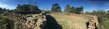
Photograph - Colour, Bessibelle Drystone Sheep Wash, 2016, 24/04/2016
The Bessiebelle Sheepwashes and Yards complex is located on the former 14,000 acre Ardonachie Run, established in 1848 by pastoralist Samuel Gorrie, then carrying 6,000 sheep. In 1864 this run was subdivided into smaller runs, and the sheep washes were located within Mount Eccles and Lake Gorrie Run. The date of construction of the washes and walls is not known, although they were probably constructed within the period 1848-1864. The Bessiebelle Sheepwashes and Yards are probably the largest and most sophisticated surviving example of a traditional pastoral property sheepwash in Victoria. They clearly demonstrate the large network of races, yards and folds necessary for washing thousands of sheep over a short period of time. The Bessiebelle sheep washes apparently predate later technological changes and the necessity for hot water washing. The Bessiebelle sheepwashes and yards are of landscape significance as a cultural landscape which has been both modified by, and cleverly adapted to, an annual process that was of critical importance within the pastoral calendar. The drystone walls and races appear to evolve from the rocky terrain, and have a strong organic affinity with the prevailing harsh landscape. The drystone walls demonstrate a high level of craftsmanship and skill in their construction, and reflect the extensive scale of pastoral operations across the landscape. The Bessiebelle sheepwashes and yards are of archaeological significance to the State of Victoria. The site has not been fully surveyed but its complexity strongly suggests a potential to reveal more about the washing processes and associated pastoral occupation and activity in the area.(Heritage Victoria)drystone, bessibell, sheep race, sheep wash, agriculture -
 Ballarat Heritage Services
Photograph - Photograph - Colour, Bessiebelle drystone sheep yards, 2016, 24/04/2016
Colour panoramic photographs of drystoen sheep yards at Bessiebelle, Victoria.bessiebell, drystone, sheep, sheep race, sheep wash, sheep yard, farm, agriculture -
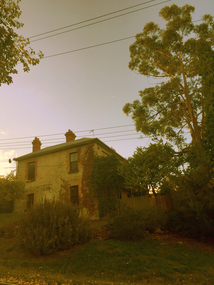 Ballarat Heritage Services
Photograph - Photograph - Colour, Clare Gervasoni, House in Sebastopol Street, Ballarat, 2016, 11/04/2016
Double storey house in Sebastopol Street, Ballarat near the Yarrowee Creek.villa, ballarat, architecture, sebastopol street -
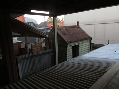 Old Colonists' Association of Ballarat Inc.
Photograph, Clare Gervasoni, Back Yard at the Ballarat Old Colonist's Club, 2016, 04/02/2016
Three photographs showing the shedding and fencing at the rear of the Ballarat Old Colonists' Club. Originally the toilets were located in the sheds in the yard.ballarat old colonists' club, backyard, yard, shed, toilet, fence, corrugated iron roof -
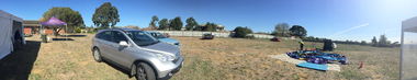 Old Colonists' Association of Ballarat Inc.
Photograph - Colour, Charles Anderson Grove Picnic (Pre Building new Units), 2016, 03/04/2016
Panoramic images of a picnic at Charles Anderson Grove retirement village before the community centre was built. charles anderson grove, ballarat old colonists' association picnic, retirement village -
 Eltham District Historical Society Inc
Audio - Audio Recording, Audio Recording; 2016-06-08 Norm Williams and Thompson's Pharmacy, 8 Jun 2016
June Meeting (Newsletter No. 228, Jun. 2016) Shortly after the First World War Ivan Thompson, a pharmacist in Fairfield, expanded into the Diamond Valley by opening pharmacies at Eltham, Greensborough and Watsonia. A small item in the Hurstbridge Advertiser on 20th July 1928 states that ‘Mr. Ivan J Thompson, well known chemist, has opened a branch at Eltham where all prescriptions will be dispensed.’ In the early 1950’s Norm Williams considered he was fortunate to be able to serve an apprenticeship with Ivan Thompson at his Eltham pharmacy. He was with the business when it moved in 1952 to the present site at 964 Main Road, Eltham, which was the first brick shop built in the Eltham Town Centre. In 1958 Ivan Thompson decided to sell his pharmacies. Harry Brown and Norm Williams were able to purchase the Eltham business and they continued in partnership until Mr. Brown’s death in 1971. By that time they had expanded with pharmacies in Fairfield and Lower Plenty. At our June meeting Norm Williams will speak about how Thompsons Pharmacy developed, while continuing to supply a range of services for generations of Eltham families. His stories, supported by a collection of personal photographs, will entertain as well as give an insight into how the Eltham shopping centre has changed over the years.0:46:09 duration Digital MP3 File 65 MB audio recording, eltham district historical society, ivan thompson, norm williams, society meeting, thompson's pharmacy -
 Melbourne Tram Museum
Pamphlet, Melbourne Festival, "Melbourne Art Trams Oct 2015 - Apr 2016, 2014
Melbourne Art Trams On the rear is a photo of the SW5 731 Lesley Dumbrell Transporting Art Tram. Also notes that you can use TramTracker to find the Art Trams. Amanda Morgan - 2009 Kathy Temin - 136 Martine Corompt - 270 Louise Forthun - 209 Matthew Bird - 3509 Phillip Adams - 3509 Tom Vincent - 925 Stephen Banham - 3008 James Voller - 175 Lesley Dumbrell - 731 Two copies heldYields information about the 2015-2016 Melbourne Art TramsPamphlet, folded sheet to give a DL size, pink background titled "Melbourne Art Trams" - Oct. 2015 to April 2016, vote for your favourite tram in the People's choice awards! - part of the Melbourne festival. Notes the Transporting Art trams. Inside the pamphlet are images of the artwork on 8 different trams including the artist names and title of the work if any. Has Melbourne Festival, Yarra Trams, PTV, Arts Victoria and Victorian Govt. logos.trams, tramways, yarra trams, transporting art, decorated trams, exhibitions, tram 731, tram 925, tram 3509, tram 151, tram 252, tram 3008, tram 209, tram 259, tram 158 -
 Eltham District Historical Society Inc
Photograph, Liz Pidgeon, Heritage Excursion; Maroondah Aqueduct, 3 September 2016, 3 September 2016
Newsletter No., 229, August 2016 Heritage Excursion - Maroondah Aqueduct Walk - Saturday 3rd September The Maroondah Aqueduct was once a major link in Melbourne’s water supply system. It was built between 1886 and 1891 to transfer water from the Watts River near Healesville to the Preston Reservoir. It was 66 km in length, made up of 41 km of open channel, 10 km of tunnel through hills and 15 km of pipeline across stream valleys known as inverted siphons. The section of the aqueduct through the Eltham area has been abandoned since the 1980s but the open channel has largely been retained. A recreational path follows the aqueduct reserve. For our excursion on 3rd September we intend to walk along the section of the aqueduct adjacent to Allendale Road. This is a section not visited on previous excursions and includes the transition from open channel to the inverted siphon across the Diamond Creek valley. Apart from the aqueduct itself the main feature of the walk is the extensive views across Eltham North and Diamond Creek. Along the way we will talk about the history of the aqueduct and the area. This easy walk is about 3 km return and will take 2 to 2.5 hours. It will start at 2pm at the junction of Allendale Road with Godber Road and Zig Zag Road North, officially Diamond Creek, but on the northern boundary of Eltham. (Melway ref.12 B10). Born Digitalmaroondah aqueduct, eltham north, activities, eltham district historical society, heritage excursion, acqueduct trail, sign -
 Eltham District Historical Society Inc
Photograph, Liz Pidgeon, Heritage Excursion; Maroondah Aqueduct, 3 September 2016, 3 September 2016
Newsletter No., 229, August 2016 Heritage Excursion - Maroondah Aqueduct Walk - Saturday 3rd September The Maroondah Aqueduct was once a major link in Melbourne’s water supply system. It was built between 1886 and 1891 to transfer water from the Watts River near Healesville to the Preston Reservoir. It was 66 km in length, made up of 41 km of open channel, 10 km of tunnel through hills and 15 km of pipeline across stream valleys known as inverted siphons. The section of the aqueduct through the Eltham area has been abandoned since the 1980s but the open channel has largely been retained. A recreational path follows the aqueduct reserve. For our excursion on 3rd September we intend to walk along the section of the aqueduct adjacent to Allendale Road. This is a section not visited on previous excursions and includes the transition from open channel to the inverted siphon across the Diamond Creek valley. Apart from the aqueduct itself the main feature of the walk is the extensive views across Eltham North and Diamond Creek. Along the way we will talk about the history of the aqueduct and the area. This easy walk is about 3 km return and will take 2 to 2.5 hours. It will start at 2pm at the junction of Allendale Road with Godber Road and Zig Zag Road North, officially Diamond Creek, but on the northern boundary of Eltham. (Melway ref.12 B10). Born Digitalmaroondah aqueduct, eltham north, activities, eltham district historical society, heritage excursion, acqueduct trail, diamond creek -
 Eltham District Historical Society Inc
Photograph, Liz Pidgeon, Heritage Excursion; Maroondah Aqueduct, 3 September 2016, 3 September 2016
Newsletter No., 229, August 2016 Heritage Excursion - Maroondah Aqueduct Walk - Saturday 3rd September The Maroondah Aqueduct was once a major link in Melbourne’s water supply system. It was built between 1886 and 1891 to transfer water from the Watts River near Healesville to the Preston Reservoir. It was 66 km in length, made up of 41 km of open channel, 10 km of tunnel through hills and 15 km of pipeline across stream valleys known as inverted siphons. The section of the aqueduct through the Eltham area has been abandoned since the 1980s but the open channel has largely been retained. A recreational path follows the aqueduct reserve. For our excursion on 3rd September we intend to walk along the section of the aqueduct adjacent to Allendale Road. This is a section not visited on previous excursions and includes the transition from open channel to the inverted siphon across the Diamond Creek valley. Apart from the aqueduct itself the main feature of the walk is the extensive views across Eltham North and Diamond Creek. Along the way we will talk about the history of the aqueduct and the area. This easy walk is about 3 km return and will take 2 to 2.5 hours. It will start at 2pm at the junction of Allendale Road with Godber Road and Zig Zag Road North, officially Diamond Creek, but on the northern boundary of Eltham. (Melway ref.12 B10). Born Digitalmaroondah aqueduct, eltham north, activities, eltham district historical society, heritage excursion, acqueduct trail, sign -
 Eltham District Historical Society Inc
Photograph, Liz Pidgeon, Heritage Excursion; Maroondah Aqueduct, 3 September 2016, 3 September 2016
Newsletter No., 229, August 2016 Heritage Excursion - Maroondah Aqueduct Walk - Saturday 3rd September The Maroondah Aqueduct was once a major link in Melbourne’s water supply system. It was built between 1886 and 1891 to transfer water from the Watts River near Healesville to the Preston Reservoir. It was 66 km in length, made up of 41 km of open channel, 10 km of tunnel through hills and 15 km of pipeline across stream valleys known as inverted siphons. The section of the aqueduct through the Eltham area has been abandoned since the 1980s but the open channel has largely been retained. A recreational path follows the aqueduct reserve. For our excursion on 3rd September we intend to walk along the section of the aqueduct adjacent to Allendale Road. This is a section not visited on previous excursions and includes the transition from open channel to the inverted siphon across the Diamond Creek valley. Apart from the aqueduct itself the main feature of the walk is the extensive views across Eltham North and Diamond Creek. Along the way we will talk about the history of the aqueduct and the area. This easy walk is about 3 km return and will take 2 to 2.5 hours. It will start at 2pm at the junction of Allendale Road with Godber Road and Zig Zag Road North, officially Diamond Creek, but on the northern boundary of Eltham. (Melway ref.12 B10). Born Digitalmaroondah aqueduct, eltham north, activities, eltham district historical society, heritage excursion, acqueduct trail -
 Eltham District Historical Society Inc
Photograph, Liz Pidgeon, Heritage Excursion; Maroondah Aqueduct, 3 September 2016, 3 September 2016
Intersection with local Street signs Newsletter No., 229, August 2016 Heritage Excursion - Maroondah Aqueduct Walk - Saturday 3rd September The Maroondah Aqueduct was once a major link in Melbourne’s water supply system. It was built between 1886 and 1891 to transfer water from the Watts River near Healesville to the Preston Reservoir. It was 66 km in length, made up of 41 km of open channel, 10 km of tunnel through hills and 15 km of pipeline across stream valleys known as inverted siphons. The section of the aqueduct through the Eltham area has been abandoned since the 1980s but the open channel has largely been retained. A recreational path follows the aqueduct reserve. For our excursion on 3rd September we intend to walk along the section of the aqueduct adjacent to Allendale Road. This is a section not visited on previous excursions and includes the transition from open channel to the inverted siphon across the Diamond Creek valley. Apart from the aqueduct itself the main feature of the walk is the extensive views across Eltham North and Diamond Creek. Along the way we will talk about the history of the aqueduct and the area. This easy walk is about 3 km return and will take 2 to 2.5 hours. It will start at 2pm at the junction of Allendale Road with Godber Road and Zig Zag Road North, officially Diamond Creek, but on the northern boundary of Eltham. (Melway ref.12 B10). Born Digitalmaroondah aqueduct, eltham north, activities, eltham district historical society, heritage excursion, street signs, acqueduct trail, allendale rd, godber rd, zig zag road, intersection -
 Eltham District Historical Society Inc
Photograph, Liz Pidgeon, Heritage Excursion; Maroondah Aqueduct, 3 September 2016, 3 September 2016
Newsletter No., 229, August 2016 Heritage Excursion - Maroondah Aqueduct Walk - Saturday 3rd September The Maroondah Aqueduct was once a major link in Melbourne’s water supply system. It was built between 1886 and 1891 to transfer water from the Watts River near Healesville to the Preston Reservoir. It was 66 km in length, made up of 41 km of open channel, 10 km of tunnel through hills and 15 km of pipeline across stream valleys known as inverted siphons. The section of the aqueduct through the Eltham area has been abandoned since the 1980s but the open channel has largely been retained. A recreational path follows the aqueduct reserve. For our excursion on 3rd September we intend to walk along the section of the aqueduct adjacent to Allendale Road. This is a section not visited on previous excursions and includes the transition from open channel to the inverted siphon across the Diamond Creek valley. Apart from the aqueduct itself the main feature of the walk is the extensive views across Eltham North and Diamond Creek. Along the way we will talk about the history of the aqueduct and the area. This easy walk is about 3 km return and will take 2 to 2.5 hours. It will start at 2pm at the junction of Allendale Road with Godber Road and Zig Zag Road North, officially Diamond Creek, but on the northern boundary of Eltham. (Melway ref.12 B10). Born Digitalmaroondah aqueduct, eltham north, activities, eltham district historical society, heritage excursion, acqueduct trail -
 Eltham District Historical Society Inc
Photograph, Liz Pidgeon, Heritage Excursion; Maroondah Aqueduct, 3 September 2016, 3 September 2016
Property related to Yarra Valley Water, Diamond Creek Newsletter No., 229, August 2016 Heritage Excursion - Maroondah Aqueduct Walk - Saturday 3rd September The Maroondah Aqueduct was once a major link in Melbourne’s water supply system. It was built between 1886 and 1891 to transfer water from the Watts River near Healesville to the Preston Reservoir. It was 66 km in length, made up of 41 km of open channel, 10 km of tunnel through hills and 15 km of pipeline across stream valleys known as inverted siphons. The section of the aqueduct through the Eltham area has been abandoned since the 1980s but the open channel has largely been retained. A recreational path follows the aqueduct reserve. For our excursion on 3rd September we intend to walk along the section of the aqueduct adjacent to Allendale Road. This is a section not visited on previous excursions and includes the transition from open channel to the inverted siphon across the Diamond Creek valley. Apart from the aqueduct itself the main feature of the walk is the extensive views across Eltham North and Diamond Creek. Along the way we will talk about the history of the aqueduct and the area. This easy walk is about 3 km return and will take 2 to 2.5 hours. It will start at 2pm at the junction of Allendale Road with Godber Road and Zig Zag Road North, officially Diamond Creek, but on the northern boundary of Eltham. (Melway ref.12 B10). Born Digitalmaroondah aqueduct, eltham north, activities, eltham district historical society, heritage excursion, yarra valley water, diamond creek -
 Eltham District Historical Society Inc
Photograph, Liz Pidgeon, Heritage Excursion; Maroondah Aqueduct, 3 September 2016, 3 September 2016
Sign for Yarra Valley Water at Diamond Creek property Newsletter No., 229, August 2016 Heritage Excursion - Maroondah Aqueduct Walk - Saturday 3rd September The Maroondah Aqueduct was once a major link in Melbourne’s water supply system. It was built between 1886 and 1891 to transfer water from the Watts River near Healesville to the Preston Reservoir. It was 66 km in length, made up of 41 km of open channel, 10 km of tunnel through hills and 15 km of pipeline across stream valleys known as inverted siphons. The section of the aqueduct through the Eltham area has been abandoned since the 1980s but the open channel has largely been retained. A recreational path follows the aqueduct reserve. For our excursion on 3rd September we intend to walk along the section of the aqueduct adjacent to Allendale Road. This is a section not visited on previous excursions and includes the transition from open channel to the inverted siphon across the Diamond Creek valley. Apart from the aqueduct itself the main feature of the walk is the extensive views across Eltham North and Diamond Creek. Along the way we will talk about the history of the aqueduct and the area. This easy walk is about 3 km return and will take 2 to 2.5 hours. It will start at 2pm at the junction of Allendale Road with Godber Road and Zig Zag Road North, officially Diamond Creek, but on the northern boundary of Eltham. (Melway ref.12 B10). Born Digitalmaroondah aqueduct, eltham north, activities, eltham district historical society, heritage excursion, diamond creek, yarra valley water, sign -
 Eltham District Historical Society Inc
Photograph, Liz Pidgeon, Heritage Excursion; Maroondah Aqueduct, 3 September 2016, 3 September 2016
Newsletter No., 229, August 2016 Heritage Excursion - Maroondah Aqueduct Walk - Saturday 3rd September The Maroondah Aqueduct was once a major link in Melbourne’s water supply system. It was built between 1886 and 1891 to transfer water from the Watts River near Healesville to the Preston Reservoir. It was 66 km in length, made up of 41 km of open channel, 10 km of tunnel through hills and 15 km of pipeline across stream valleys known as inverted siphons. The section of the aqueduct through the Eltham area has been abandoned since the 1980s but the open channel has largely been retained. A recreational path follows the aqueduct reserve. For our excursion on 3rd September we intend to walk along the section of the aqueduct adjacent to Allendale Road. This is a section not visited on previous excursions and includes the transition from open channel to the inverted siphon across the Diamond Creek valley. Apart from the aqueduct itself the main feature of the walk is the extensive views across Eltham North and Diamond Creek. Along the way we will talk about the history of the aqueduct and the area. This easy walk is about 3 km return and will take 2 to 2.5 hours. It will start at 2pm at the junction of Allendale Road with Godber Road and Zig Zag Road North, officially Diamond Creek, but on the northern boundary of Eltham. (Melway ref.12 B10). Born Digitalmaroondah aqueduct, eltham north, activities, eltham district historical society, heritage excursion, acqueduct trail -
 Eltham District Historical Society Inc
Photograph, Liz Pidgeon, Heritage Excursion; Maroondah Aqueduct, 3 September 2016, 3 September 2016
View of Diamond Creek Newsletter No., 229, August 2016 Heritage Excursion - Maroondah Aqueduct Walk - Saturday 3rd September The Maroondah Aqueduct was once a major link in Melbourne’s water supply system. It was built between 1886 and 1891 to transfer water from the Watts River near Healesville to the Preston Reservoir. It was 66 km in length, made up of 41 km of open channel, 10 km of tunnel through hills and 15 km of pipeline across stream valleys known as inverted siphons. The section of the aqueduct through the Eltham area has been abandoned since the 1980s but the open channel has largely been retained. A recreational path follows the aqueduct reserve. For our excursion on 3rd September we intend to walk along the section of the aqueduct adjacent to Allendale Road. This is a section not visited on previous excursions and includes the transition from open channel to the inverted siphon across the Diamond Creek valley. Apart from the aqueduct itself the main feature of the walk is the extensive views across Eltham North and Diamond Creek. Along the way we will talk about the history of the aqueduct and the area. This easy walk is about 3 km return and will take 2 to 2.5 hours. It will start at 2pm at the junction of Allendale Road with Godber Road and Zig Zag Road North, officially Diamond Creek, but on the northern boundary of Eltham. (Melway ref.12 B10). Born Digitalmaroondah aqueduct, eltham north, activities, eltham district historical society, heritage excursion, diamond creek, acqueduct trail -
 Eltham District Historical Society Inc
Photograph, Liz Pidgeon, Heritage Excursion; Maroondah Aqueduct, 3 September 2016, 3 September 2016
Russell Yeomann provides historical information on the heritage excursion From the Newsletter No., 229, August 2016 Heritage Excursion - Maroondah Aqueduct Walk - Saturday 3rd September The Maroondah Aqueduct was once a major link in Melbourne’s water supply system. It was built between 1886 and 1891 to transfer water from the Watts River near Healesville to the Preston Reservoir. It was 66 km in length, made up of 41 km of open channel, 10 km of tunnel through hills and 15 km of pipeline across stream valleys known as inverted siphons. The section of the aqueduct through the Eltham area has been abandoned since the 1980s but the open channel has largely been retained. A recreational path follows the aqueduct reserve. For our excursion on 3rd September we intend to walk along the section of the aqueduct adjacent to Allendale Road. This is a section not visited on previous excursions and includes the transition from open channel to the inverted siphon across the Diamond Creek valley. Apart from the aqueduct itself the main feature of the walk is the extensive views across Eltham North and Diamond Creek. Along the way we will talk about the history of the aqueduct and the area. This easy walk is about 3 km return and will take 2 to 2.5 hours. It will start at 2pm at the junction of Allendale Road with Godber Road and Zig Zag Road North, officially Diamond Creek, but on the northern boundary of Eltham. (Melway ref.12 B10). Born Digitalmaroondah aqueduct, eltham north, activities, eltham district historical society, heritage excursion, russell yeoman, aqueduct trail -
 Eltham District Historical Society Inc
Photograph, Liz Pidgeon, Heritage Excursion; Maroondah Aqueduct, 3 September 2016, 3 September 2016
Newsletter No., 229, August 2016 Heritage Excursion - Maroondah Aqueduct Walk - Saturday 3rd September The Maroondah Aqueduct was once a major link in Melbourne’s water supply system. It was built between 1886 and 1891 to transfer water from the Watts River near Healesville to the Preston Reservoir. It was 66 km in length, made up of 41 km of open channel, 10 km of tunnel through hills and 15 km of pipeline across stream valleys known as inverted siphons. The section of the aqueduct through the Eltham area has been abandoned since the 1980s but the open channel has largely been retained. A recreational path follows the aqueduct reserve. For our excursion on 3rd September we intend to walk along the section of the aqueduct adjacent to Allendale Road. This is a section not visited on previous excursions and includes the transition from open channel to the inverted siphon across the Diamond Creek valley. Apart from the aqueduct itself the main feature of the walk is the extensive views across Eltham North and Diamond Creek. Along the way we will talk about the history of the aqueduct and the area. This easy walk is about 3 km return and will take 2 to 2.5 hours. It will start at 2pm at the junction of Allendale Road with Godber Road and Zig Zag Road North, officially Diamond Creek, but on the northern boundary of Eltham. (Melway ref.12 B10). Born Digitalmaroondah aqueduct, eltham north, activities, eltham district historical society, heritage excursion, water-pipes, pipes, cattle yard, aqueduct trail