Showing 874 items
matching 81
-
 Ringwood and District Historical Society
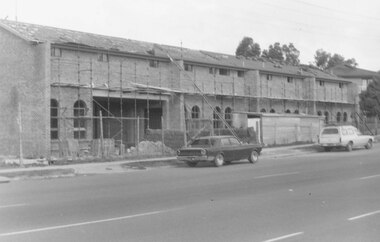
Photograph, Ringwood Motor Inn, Maroondah Highway, 1981
Written on back of photograph, "24/7/81. Ringwood Motor Inn, Maroondah Highway." -
 Ringwood and District Historical Society
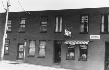
Photograph, Street Scenes. Commercial premises in Ringwood Street, corner of Bond Street, Ringwood - 18/5/1981
Ringwood Street, corner of Bond StWritten on back of photograph, "18/5/81. Ringwood Street, corner of Bond St." -
 Ringwood and District Historical Society
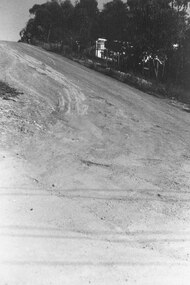
Photograph, Corner of Oban and Glenvale Roads (top). North Ringwood. 1981
Written on back of photograph, "18/4/81. Corner of Oban and Glenvale Roads (top)". -
 Glenelg Shire Council Cultural Collection
Photograph - Photograph - construction, Portland Harbour, 1981
Port of Portland Authority ArchivesBack: PRE-CAST SLABS 4 ALCOA WHARF DECK 8/1/81port of portland archives, construction, concrete, slbs, truck, portland harbour -
 Coal Creek Community Park & Museum
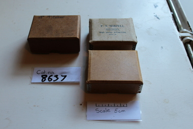
False teeth boxes
8628.1 - Brown denture box (largest) 8628.2 - Light brown denture box 8628.3 - lightest brown denture box- Mr Mc Miller - F.S. Serpell Dentistry - High Street, Kyneton - Phone 81 -
 Robin Boyd Foundation
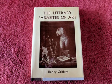
Book, Harley Griffiths, The Literary Parasites of Art, 1980
Hardcover w/ Dust JacketSigned by Author inside front cover, special edition, numbered 81 of 500 copieswalsh st library -
 Ruyton Girls' School
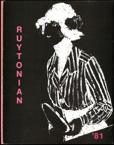
Magazine, Ruyton Girls' School, The Ruytonian, 1981
In July 1909, a modest 12-page booklet was put together by members of the fledgling Old Ruytonians Association (ORA) and distributed to the Ruyton Girls' School community. It was one of their first projects, and their aim was to nurture continuing interest in the School among former and current students. They named it "The Ruytonian." At first, The Ruytonian was produced twice yearly, and always bore a plain cover with a simple name banner. Initially, it was the work of volunteer editors from the ORA, but in 1913 they handed the publication over to the first student editors, Esther Gibson and Lucy Tickell. Since that time, the style and content of The Ruytonian has continuously evolved. The biggest shifts occurred in 1942 when it transitioned to a yearly publication, and in 1969 when it moved to a larger A4 format with a cover image specifically selected for that year.The record has strong historic significance as it pertains to the fourth oldest girls' school in Victoria, Australia. Ruyton was founded in 1878 in the Bulleen Road, Kew, home of newly widowed Mrs Charlotte Anderson (now High Street South). Thus, the record can be used as a reference example for research into Victorian school history. The record's significance is further enhanced by its exceptionally well-documented provenance, having remained the property of Ruyton Girls' School since its production.Colour publication printed on white and black coloured paper. 47 pages.Front Cover: R / U / Y / T / O / N / I / A / N / '81 /ruyton girls' school, the ruytonian, kew, old ruytonians association, yearbook, school, publication, girls school, junior school, senior school, journal, students, teacher -
 Bendigo Historical Society Inc.
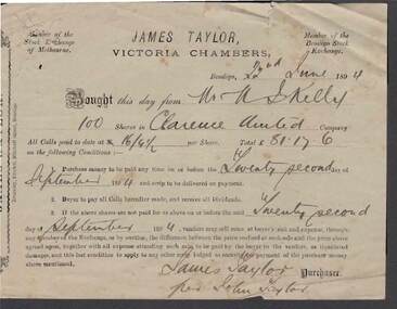
Document - KELLY AND ALLSOP COLLECTION: RECEIPT FOR SHARES IN CLARENCE UNITED
Green printed and handwritten receipt for 100 shares in Clarence United on 22/6/1894. Bought from Mr. M. Kelly, total value of £81/17/6. Signed James Taylor per John Taylor.business, stockbroker, kelly & allsop, kelly & allsop collection - receipt for shares in clarence united, james taylor, m kelly, clarence united, john taylor, brockley -
 Ballarat Tramway Museum
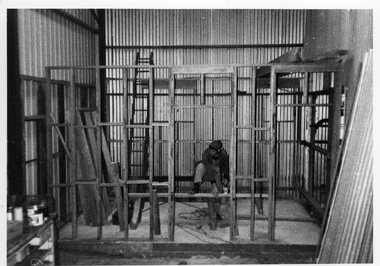
Photograph - Black & White Photograph/s, Carolyn Dean, 1981
Black and White photograph of John Phillips constructing the framework for the toilet change room area in the NW corner of the depot, 1980 or 1981. Reported on work being commenced in the 1980 - 81 Annual report. Photo Carolyn Dean. tramways, trams, btps, depot -
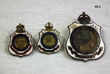 Bendigo Military Museum
Badge - RSL BADGES, 2) Stokes & Sons
.1) “81” on the badge denotes owner was a financial member of the RSL in 1981. .2 & .3) Possibly issued to WWI veteran..1) Enamelled Returned Soldier's, Sailors & Airmen badge with metal crown attached to top. .2) & .3) Returned Soldiers & Sailors Imperial League badge..1) 66280 on rear. Badge remains property of League Stokes Melb. Copyright V80458. .2) Copyright V69575 Stokes & Sons Melbourne. .3) Copyright 65280.badges, membership, rsl -
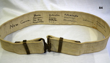 Bendigo Military Museum
Equipment - WEBBING BELT, c.WWII
Belt belonged to William Herbert GREENMAN VX126789, 2nd AIF. Refer Cat No 81 for his service details and other.Khaki webbing belt with connecting brass buckle. Hand written in dark ink: Signature of Greenman W H, & names/places of theatres of war where he served in the Pacific.webbing belts, eqyuipment -
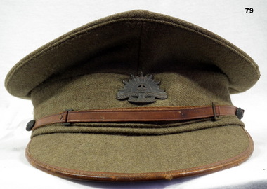 Bendigo Military Museum
Headwear - CAP, UNIFORM, C. 1939
Item issued to William Herbert GREENMAN VX126789, 2nd AIF. Refer Cat No 81 for his service details and other.Khaki wool peaked cap with leather trim on peak and leather chin strap. Rising Sun badge on front. Inside cap: VX126789 WILS, 7 1/8 (size) On badge: Australian Commonwealth Military Forceuniforms - army, head wear -
 Eltham District Historical Society Inc
Photograph, Shoestring
Stamped on back: Neville F. Emerson Estate Agent 81 Main Rd. Lower Plenty. Inscribed with the name JoyceBlack and white photographhouses, neville emerson real estate, shoestring -
 Eltham District Historical Society Inc
Photograph, Unidentified house, possibly Eltham area
Stamped on back: Neville F. Emerson Estate Agent 81 Main Rd. Lower Plenty. Inscribed with the name JoyceBlack and white photographhouses, neville emerson real estate -
 Eltham District Historical Society Inc
Photograph, Unidentified house, possibly Eltham area
Stamped on back: Neville F. Emerson Estate Agent 81 Main Rd. Lower Plenty. Inscribed with the name JoyceBlack and white photographhouses, neville emerson real estate -
 Eltham District Historical Society Inc
Photograph, Unidentified house, possibly Eltham area
Stamped on back: Neville F. Emerson Estate Agent 81 Main Rd. Lower Plenty. Inscribed with the name JoyceBlack and white photographhouses, neville emerson real estate -
 Eltham District Historical Society Inc
Photograph, Shoestring
Stamped on back: Neville F. Emerson Estate Agent 81 Main Rd. Lower Plenty. Inscribed with the name JoyceBlack and white photographhouses, neville emerson real estate, shoestring -
![Drawing, F. Zinger, [Townscape]](/media/collectors/57a00a4fd0cdd1210422a51e/items/63e722e18b6b08140b56fb7b/item-media/63e723528b6b08140b570cb9/item-fit-380x285.jpg) Ballarat Heritage Services
Ballarat Heritage ServicesDrawing, F. Zinger, [Townscape]
Stamped on back of frame "International Art 81 Kerk Street PO Box 10455 (Opp Langham Hotel) Johannesburg.Framed townscape. A woman collects water in the right foreground. If you can provide information on this artist or artwork please use the link below. LRS "F.N. Zinger"painting, townscape -
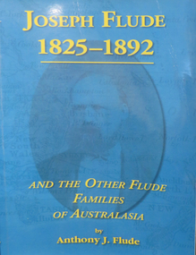 Federation University Historical Collection
Book - Family History, PenFolk Publishing et al, Joseph Flude 1825 - 1892, 2003
Blue paperback book, 81 pages, this book contains information on the Flude families of Australasia, Joseph Flude lectured at the School of Mines and Industries in 1871, " he offered his services gratuitously". He lectured in Inorganic Chemistry and Metallurgy. non-fictionschool of mines, joseph flude, flude family history, robert malachy sergeant, chemistry, metallurgy, ballarat school of mines self-acting pyrites furnace, ballarat school of mines, family history, genealogy, herbert werner frederick de nully -
The Ed Muirhead Physics Museum
Magnetic Dip Circle
Dip circle has much the same elments as in the previous model ( cat. no.81), except the brass cylinder is replaced by a mahogany box with two end windows. Tribrach base is fixed into a wooden sheet ( maybe for ease of carrying in the field).Label: “Nat Phil Lab No. Univ. of Melb” Magnets inscribed “Magnets for dip” -
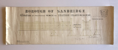 Port Melbourne Historical & Preservation Society
Plan, Charles Clay, Borough Surveyor, Elevation of Proposed Fence to Station Place Reserve, c. 1881
Although undated, the plan is probably from 1880-81. The plan is signed by Charles CLAY, Fred WILLIAMS and Witney Henry BATES. Charles CLAY was the Borough Surveyor from 1860 to 1884. Fred WILLIAMS was a Councillor 1875 to 1886 and served as Mayor, 1880-81. It is not known who Witney Henry BATES was. A note in pencil, probably added later, indicates the fence was between Graham and Bridge Streets.Undated Borough of Sandridge hand-drawn plan for a proposed picket fence at Station Place Reserve.'between Graham and Bridge Streets' handwritten in pencil below and to the right of the main title.local government - borough of sandridge, engineering - fences, charles clay, witney henry bates, frederick williams -
 Running Rabbits Military Museum operated by the Upwey Belgrave RSL Sub Branch
Photo
Artillery Battery Photo probably Britishphoto, army -
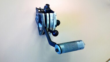 Nhill Aviation Heritage Centre
Memorabilia - Aircraft engine hand control unit
Hand slide control for throttle, mixture and propeller Assy 16-1131-001 -
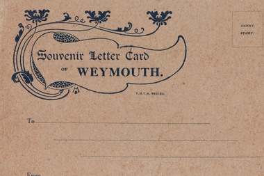 Lara RSL Sub Branch
Postcards Booklet, Souvenir Letter Card of Weymouth
Following the landing of Australian & New Zealand troops, the Anzacs, at Gallipoli on 25th April 1915, casualties mounted rapidly and were initially transported to their base in Egypt, which was soon unable to cope, with wounded being sent to England. Here the troops found that there was no Australian base to which they could report once they had been discharged from hospital; what was needed urgently was a base in England where troops could be sent to convalesce. So on 31st May 1915 a command depot was set up at Monte Video House in Chickerell, some two miles from Weymouth. Weymouth then became the Australian Imperial Forces (AIF) Command Depot No.2 which accommodated those men not expected to be fit for duty within six months, therefore, most of the Diggers repatriated as a result of wounds or sickness passed through Weymouth. During the years 1915-1919 over 120,000 Australian and New Zealand troops passed through Weymouth. In Spring & Summer, Weymouth Esplanade would be full of Anzac soldiers in wheelchairs, being wheeled along by their more able mates. The first contingent of 200 wounded men arrived in the first week of June 1915, and two weeks later a group of local ladies organised a cream tea for the newcomers, followed by a concert party 'The Frolics' at the camp. So began the close connection that was to grow between the soldiers and the villagers of Chickerell. The ANZAC Memorial on Weymouth seafront commemorates the Australian and New Zealand troops who were accommodated in three camps in the town during WW1: Monte Video, Westham and Littlemoor. In Weymouth and Melcombe Regis Cemetery there are about eighty-six graves of those Anzacs who were never to return to their homelands. Also in memory of these troops, there a number of roads close to the camps named after Australian cities and states.A World War 1 Letter Card sent home by Australian troops repatriated in Weymouth, UK containing images of Weymouth and a picture of the Australian Base Camp.Front cover (see image) Souvenir Letter Card of Weymouth Inside are eight pictures of the Weymouth area including the YMCA Hut - Australian Base Campymca, uk, australian base camp, world war 1, ww1, aif, army, australian army, westham, littemoor, weymouth, melcombe regis cemetery, anzac -
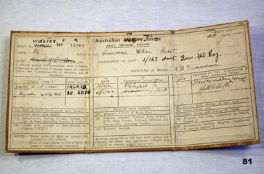 Bendigo Military Museum
Administrative record - DRIVERS LICENCE, c.1942
Licence issued to: Pte William Herbert GREENMAN VX126789. Enlisted in the 2nd AIF on 3.7.1943 age 19 years. At discharge from the Army on 19.10.1948 he was a Driver in No 53 Aust BIPOD PL AASC. Refer Reg No's 79, 82, 83, 84, 85.5, 86. Australian Army Driving Licence No 10782. Tan buckram stiff folding cover.Top centre: Australian Military Forces Left: Army No. VX126789 Left: Pte Centre: Name (in full): Greenman, William Herbert Right: Transferred to (unit): 2/167 Aust Gen Tpt Coy"documents - licences, military history - army, personal effects - identification -
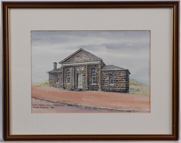 Glenelg Shire Council Cultural Collection
Painting - Painting - Old Town Hall Portland, Pauline Grayling, 1983
View of bluestone building with false columns decorating front of central structure. The building is situated on the side of a road, with red sand/gravel in front and low-lying greenery behind. Mounted in cream matt and framed in a wooden frame.Front: Old Town Hall, Portland (1863) Pauling Grayling 1983 (Black Ink) Back: Old Town Hall/Portland - $100 (Pauline Grayling/42 Greenwood Ave/Ringwood 870 7649 (black felt tip pen on sticker, upper right). -
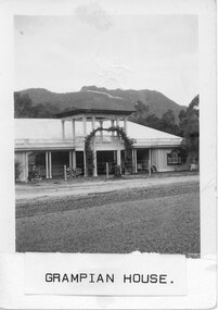 Halls Gap & Grampians Historical Society
Photograph - B/W, C 1950
Written on back in pencil, however comparison with record 82 suggests that photo may have been taken earlier than 1945. Guest house with young plantings in garden.Grampian House accommodation, planted with arbour at entranceaccommodation, guesthouses, grampian house -
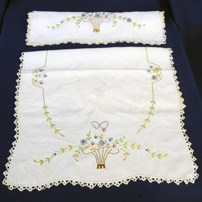 Orbost & District Historical Society
pillow shams, first half 20th century
This item is an example of a handcrafted item and reflects the needlework skills of women in the early to mid 20th century. Embroidery was an affordable way to personalise and add aesthetic value to domestic linen and examples of embroidered and crocheted pieces could be found in most Australian homes, One pair of hand embroidered white linen pillow shams. Crocheted edge. Decorated with embroidered flowers in assorted colours.pillow shams bedding manchester handcrafts needlework embroidery -
Blacksmith's Cottage and Forge
meat plate
Used domestically for the serving of carved meat to the tableAn oval china plate with scalloped edges and a blue floral and pheasant pattern.The number 10 imprinted on the base. A.F.S.S in blue scroll with flowerschina, plate, porcelain, dish, meatdish, serving, crockery domestic dining -
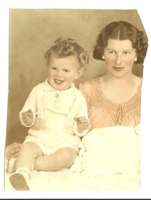 Bendigo Historical Society Inc.
Photograph - MOTHER AND CHILD PORTRAIT, 1940's
studio portrait, part thereof, female with seated child. Coloured by hand. RH side of photo cut off - person removed.unknownperson, family