Showing 2587 items matching "aerial"
-
 Ringwood and District Historical Society
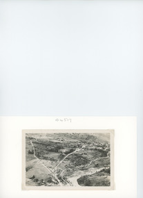
Photograph, Composite Aerial Views of Ringwood, Victoria - 1972
Two composite black & white aerial photographs with north-facing view over Maroondah Highway, including Railway Station precinct, Civic Centre precinct, Eastland, Mount Dandenong Road, Bedford Road, Ringwood Street, Warrandyte Road, Mullum Road, Loughnan's Road.Department of Crown Lands and Survey. Maroondah Highway Project - Run 3 - 20.1.72 - 3,900' ASL. -
 Southern Sherbrooke Historical Society Inc.
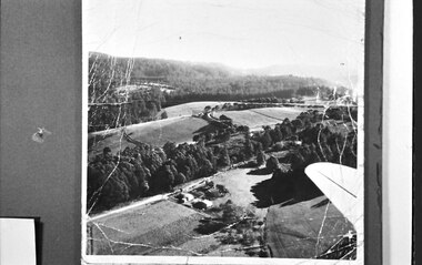
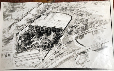
Photograph, Aerial view of Cotswold Valley
Aerial view of Cotswold Valley, Menzies Creek. B&W photos taken from light plane. Paddocks and treed areas are visible. Two houses are in the centre of the photo, presumably the Breen farmhouse on Jacksons Hill Road. The tip of the plane's left wing is also visible. -
 Vision Australia
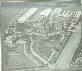
Photograph - Image, Aerial view of the Royal Victorian Institute for the Blind grounds in St Kilda Road, 1927
Aerial photo of the RVIB St Kilda Road buildings and grounds, scanned from an unknown printed source. On the image are written descriptions of buildings, including the width and length of those erected in 1920's, the isolation hospital and the segregation of boys and girls playing areas. 1 scanned image of RVIB St Kilda Road from airGirls playground School & residential buildings Boys playground Isolation hospital This building, erected in 1926 - is 200 ft long & 40 ft wide Each floor of this new two storied building erected in 1926 is 100 ft long & 40 ft wide These recently erected factories measure 20,000 sq ft Ormond Hall for socials, etc. St Kilda Road frontageroyal victorian institute for the blind, buildings -
 Bendigo Military Museum
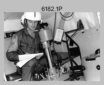
Photograph - Royal Australian Survey Corps Aerial Surveys, c1980
This is a set of nine photographs of technicians from the Royal Australian Survey Corps operating aerial surveys equipment c1980s. In photo .1P, CPL Steve Gloster was operating a RC10 air survey camera mounted in an Australian Army Pilatus Porter aircraft. The Wild RC10 super wide-angle air survey cameras were first introduced in 1971, were equipped with virtual distortion free lenses for supplementary, spot and special photography. In photo .2P, Roger Rees was operating Air Profile Recorder (APR) equipment. it was possibly taken during OP NERVOSE 84, sometime between June – August 1984 when based in Ngukurr, Northern Territory. The APR was operated at this time in unison with an RC10 camera. In 1963 the Royal Australian Survey Corps introduced the radar airborne profile recorder (Canadian Applied Research Ltd, Mark V, Airborne Profiler Recorder) was introduced for 1:100,000 mapping to replace terrain heighting by aneroid barometry. Later in 1974-1975, the Australian developed WREMAPS II airborne laser terrain profile recorder was introduced. In photo .3P, Neil Jones appears at the door of Airsearch Beechcraft Queen Air aircraft, Registration / Serial VH-MWX. This aircraft was typically used by RA Svy on air survey operations flying mission with Aerodist, APR and RC10 camera equipment. The Australian Army’s Pilatus Porter (short take-off and landing turbo propeller) was also equipped with a Wild RC10 aerial mapping camera for identification photography. The Pilatus Porter was also used on RA Svy’s map field checking operations. Photo .9P was taken at a survey station at an unknown location. In this photo an Australian Army Kiowa Light Observation Helicopter (LOH) is supporting a field survey party undertaking Magnavox AN/PRR-14 portable Doppler satellite observations. The satellite receiver’s antenna is plumbed over the survey ground mark surrounded by white plastic panels. The panels were used to identify the survey station on aerial photography. Introduced in 1974–1975, the Magnavox AN/PRR-14 portable Doppler satellite (US Navy Navigation Satellite System – TRANSIT) receivers and computing system provided independent three-dimensional point positions anywhere in the world, anytime, in any weather accurate to about 1.5metres with precise satellite ephemerides. The Bell OH-58 Kiowa LOH was a family of military helicopters used for observation, utility, and direct fire support. It was identified by RA Svy in the mid-1970s that considerable time was lost in replacing unserviceable remote equipment by road. Therefore Aerodist operations (pre-dating satellite receiver operations) were fully supported by Army’s Kiowa LOH aircraft. This is a set of nine photographs of technicians from the Royal Australian Survey Corps operating aerial surveys equipment c1980s. .1P to .3P, .5P to .9P - Colour and black and white photos on photographic paper and scanned at 300 dpi. .4P - Colour photo on 35mm slide film and scanned at 96 dpi. .1) & .2) - Photo, black & white, c1980s, CPL Steve Gloster operating an RC10 air camera. .3) - Photo, colour, 1984, Roger Rees operating Air Profile Recorder (APR) equipment. .4) - Photo, colour, c1980s, Neil Jones at the door of an Airsearch Beechcraft Queen Air aircraft, typically used by RA Svy on air survey operations. .5) - Photo, colour, c1980s. A Beechcraft King Air aircraft, also used by RA Svy on air survey operations. .6) - Photo, colour, c1980s. An Australian Army Pilatus Porter, used by RA Svy on air survey and map field checking operations. SGT Peter Mustart is possibly in the foreground. .7) to .8) - Photo, colour, c1980s. An Australian Army Pilatus Porter and unidentified personnel, used by RA Svy on air survey and map field checking operations. .9) - Photo, colour, c1980s. An Australian Army Kiowa helicopter supporting a field survey party undertaking Magnavox AN/PRR-14 portable Doppler satellite observations. There are biro marks on photos .4P to .9Proyal australian survey corps, rasvy, army survey regiment, asr, fortuna, aerial surveys -
 Ballarat Tramway Museum
Document - Photocopies, John Phillips, Bungaree Aerial photo, 1980's
Demonstrates the use of bogie trams on the Lydiard St North route and the crossing of trams at Seymour St loop.Two sets of three copies of the Victorian Railways aerial photographs of Bungaree Railway station late 1960's early 1970's. Shows tennis court, station buildings, houses and sheds in the station yard. The level crossing does not appear to have any flashing lights installed on it.trams, tramways, bungaree, aerial views, victorian railways -
 University of Melbourne, Burnley Campus Archives
Photograph - Black and white print, Aerial View of Burnley Campus c. 1930, c. 1934
Black and white photographs. Aerial Views of Burnley Campus. Enlargements. (A) Heyington Bridge to South, Yarra River on North side. (B) Heyington Bridge at top of photograph i.e. reverse view of (A). (C) Original of (B) mounted on board. Probably taken at the time of the floods of 30 November 1934. heyington bridge, yarra river, aerial view, burnley campus, 1934 flood -
 Port Fairy Historical Society Museum and Archives
Photograph
aerial view over Port Fairy looking across the river at the railway line and butter factoryBlack and white aerial photograph of Port Fairy looking across the Moyne river and railway stationaerial, railway, river, town -
 Federation University Historical Collection
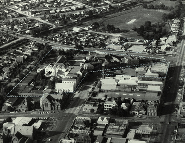
Photograph, Aerial photograph of the Ballarat School of Mines, 1983
The photo was taken before the Ballarat School of Mines built the M.B. John Building and the Hillman Recreation Centre. Since this photo has been taken most of the Ballarat Gaol and the Ballarat Brewery have been demolished.Black and white aerial photograph of central Lydiard Street south in Ballarat, including the Ballarat School of Mines. The photo shows the former Ballarat Gaol, former Ballarat Courthouse, Ballarat Club, Uniting Church, White Flat, Ballarat Brewery; and was taken before the building of Corbould Hall and the M.B. John Building. White broken lines show the Ballarat School of Mines campusballarat gaol, ballarat courthouse, ballarat club, ballarat townscape, uniting church, ballarat brewery, old plumbing building, flecknoe, administration building, flecknoe building, lydiard street south, ballarat, white flat, ballarat school of mines botanical garden -
 South Gippsland Shire Council
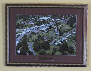
Photograph, Framed, Aerial Scene of Mirboo North, 2004
One of a set of two. Framed colour photograph titled: "Mirboo North Township 2004". Features an aerial photograph of the township of Mirboo North. Set in maroon card window mount and decorative brown and gold wood frame. Engraved brass text panel with white lined border affixed below image. -
 South Gippsland Shire Council
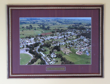
Photograph, Framed, Aerial Scene of Mirboo North, 2004
One of a set of two. Framed colour photograph titled: "Mirboo North Township 2004". Features an aerial photograph of the township of Mirboo North. Set in maroon card window mount and decorative brown and gold wood frame. Engraved brass text panel with white lined border affixed below image. -
 South Gippsland Shire Council
Photograph, Framed, Aerial town view of Mirboo North, 2004
One of a set of two. Framed colour photograph titled: "Mirboo North Township 2004". Features an aerial photograph of the township of Mirboo North. Set in maroon card window mount and decorative brown and gold wood frame. Engraved brass text panel with white lined border affixed below image. -
South Gippsland Shire Council
Photograph, Framed, Aerial Scene of Mirboo North, 2004
One of a set of two. Framed colour photograph titled: "Mirboo North Township 2004". Features an aerial photograph of the township of Mirboo North. Set in maroon card window mount and decorative brown and gold wood frame. Engraved brass text panel with white lined border affixed below image. -
 Bendigo Military Museum
Administrative record - AHQ Survey Regiment - Tests on stability of duplicate Aerial Photography negatives 1959, AHQ Survey Regiment, 8 Dec 1959
Tests on the stability of Duplicated Aerial Photography negatives. Tests were carried out using 3 x units of 2 x models from both original and duplicate films. These were all brought to a scale of 1;25,000 and horizontalized on common points and approximately 250 spot heights read on each unit.1 x A4 poorly photocopied Report. Typed text and incompleteroyal australian survey corps, rasvy, fortuna, army survey regiment, army svy regt, asr -
 Melbourne Tram Museum
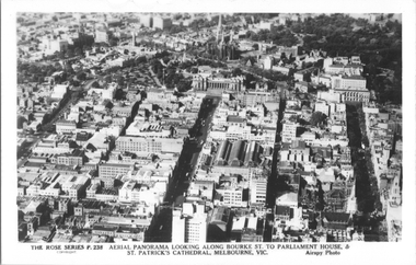
Postcard, Rose Stereograph Co, "Aerial Panorama looking along Bourke St.", mid 1940s
Rose Series postcard No. P 238, titled "Aerial Panorama looking along Bourke St. to Parliament House & St Patrick's Cathedral, Melbourne - Airspy photo" - There are buses in Bourke Street. Note the three large roof spans of the Eastern Market in the middle of the photo. Photo dated around mid-1940s.Yields information about east end of both Bourke and Collins Streets in the mid 1940s.Postcard - printed real photograph with Rose Stereograph Co. name on the rear.aerial views, melbourne, bourke st, collins st, eastern market -
 Orbost & District Historical Society
folder of documents, 1972
Orbost Aero Club began in 1969 with Basil Dowie as Chair, David Nixon as Secretary/Treasurer. The group went into recess from 1977-1991 closing in 1997. The mid 1960s were boom years in flying training in Australia and the number of Aero Clubs grew rapidly. The Club played a significant role in the establishment of the small airport at Marlo and in the ongoing operation and development of the airport over the years particularly for patient transfer by aerial ambulance. The Orbost Aero Club Club played a significant role in the establishment of the small airport at Marlo and in the ongoing operation and development of the airport over the years. A manila folder containing applications for charter, aerial work and flying school licences.On front in black - ORBOST AERO CLUB CHARTER, AERIAL WORK & FLYING SCHOOL LICENCE APPLICATION orbost-aero-club -
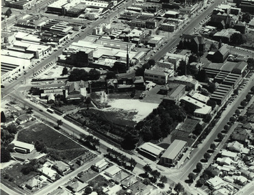
 Federation University Historical Collection
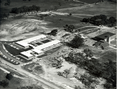
Photograph - Black and White, N. L. Harvey, Aerial Views of Mount Helen Campus, 1973, 1973
The Stage 2 buildings at the Federation University Mount Helen Campus were underway in 1973.Three aerial photographs of the Mount Helen Stage 2 building activities * Westward view of Stage 2 buildings under construction, Aug 1973 * View to the South West showing Stage 2 buildings under construction, Aug 1973 * View to the North West showing Stage 2 buildings under construction, Aug 1973federation university, federation university australia, feduni, university of ballarat, ballarat townscape, mount helen, construction, stage 2 -
 Whitehorse Historical Society Inc.
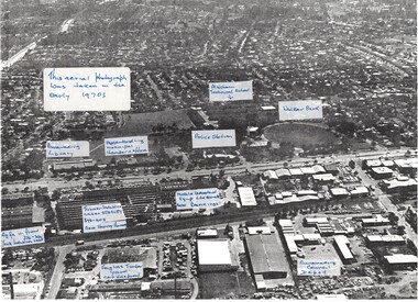
Photograph, Aerial View of various sites in Nunawading, C.1970's
2 Black and white copies of Aerial View of various sites in Nunawading. - Mitcham Technical School, Walker Park , Nunawading Police Station, Bunnings Warehouse, Mobile Industrial Equipment Ltd, Municipal Chambers, Nunawading Library, Turner Industries, Harvey Norman, Feiglins Timber Yard, Holeproof ,Agfa, York Industries and|City of Nunawading. Council Depot.mitcham technical school, walker park, nunawading police station, bunnings warehouse nunawading, mobile industrial equipment ltd., city of nunawading. council chambers, nunawading library, turner industries, harvey norman, feiglins timber yard, holeproof, agfa, york industries, city of nunawading. council depot -
 Otway Districts Historical Society
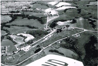
Photograph, R. Preston, Aerial view: Beech Forest, 1965, 13 February 1965
B/W. Aerial view of Beech Forest showing the complete station yard including the balloon loop (incorporating the two tennis courts), two ex-departmental residences, the station building and where the Colac and Crowes lines diverged. As well Beech Forest Hall, council offices and Shire Secretary's house, Denherts Track, and Main Road are shown.beech forest; railways; township; aerial; -
 Melbourne Legacy
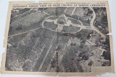
Newspaper - Article, Impressive aerial view of huge crowd at Shrine ceremony, 1934
A newspaper cutting from 1934 showing the crowd at the opening ceremony of the Shrine of Remembrance. The Shrine was officially opened by the Duke of Gloucester. The caption says 'Marshalled at the Shrine in hundreds of thousands, troops of all arms and services returned soldiers of Australian, British and Dominion units, and a countless mass of citizens, yesterday witnessed the ceremony of dedication performed by the Duke of Gloucester. This aerial view of the vast crows was taken as the Duke and his escort arrived at the southern steps.Early legatees fought hard to have the Shrine of Remembrance accepted as the preferred form of commemoration of the first World War. Early legatees would have been at this ceremony and kept this clipping as a memento.Double page spread in The Sun News-pictorial newspaper on 12 November 1934 after the opening of the Shrine.shrine of remembrance, wreath laying ceremony -
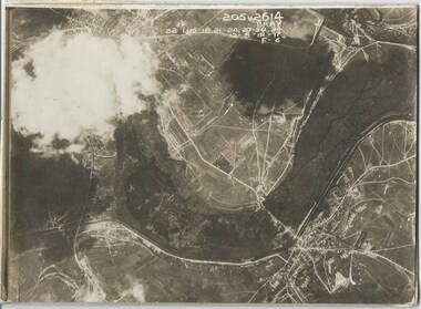
 Melbourne Legacy
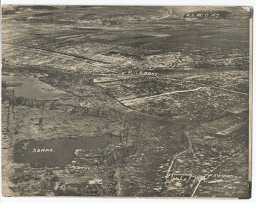
Photograph - Photo, Aerial view of the Somme
An aerial photo of the Somme Swamp in France during World War One. There are coordinates or numbers in some areas. Was with 11 other photos of World War One that had been mounted on board for display at Legacy House at some stage. When they were taken off display they were put in the archive cabinets. The founding legatees all served in World War One so these photos would have been of significant places for them. (see 01888 to 01899)Photos from World War One that would have been significant to the founding legatees.Sepia photo of the Somme battlefield in France during World War One.world war one, france, somme -
 Federation University Historical Collection
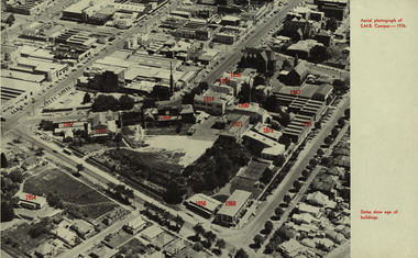
Photograph - Image, Aerial Image of the Ballarat School of Mines, 1976, 1976
Black and white aerial Image of the Ballarat School of Mines, with the date of the construction of each building indicated in red. The image shows the site after the Ballarat Gaol and the Ballarat Brass Works (M.B. John) buildings have been demolished. It includes the former Battery Building, tennis court which were demolished to make way for the M.B. John Building on Albert Street. It also shows the former Ballarat Girls' Technical School.former ballarat gaol, former ballarat brass works, m.b. john building, battery building, tennis court, albert street, grant street, lydiard street south, armstrong street south, ballarat girls' technical school. -
 Melbourne Legacy
Photograph - Photo, Aerial view of the Somme
An aerial photo of the Somme in France during World War One. There are coordinates or numbers in some areas. Also labelled is Bray. Was with 11 other photos of World War One that had been mounted on board for display at Legacy House at some stage. When they were taken off display they were put in the archive cabinets. The founding legatees all served in World War One so these photos would have been of significant places for them. (see 01888 to 01899)Photos from World War One that would have been significant to the founding legatees.Sepia photo of the Somme battlefield in France during World War One.world war one, france, somme -
Glenelg Shire Council Cultural Collection
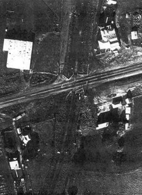
Photograph - Photograph - aerial view of railway between Heywood and Rennick, 03/05/1952
Black and white aerial photographs (aerial survey record print) of the railway line between Heywood and Rennick (S.A. border) Taken for Victorian Railways, May 1952. Some photos have annotations later added to the front of the image in penVictorian Railways aerial survey record print of the railway line between Heywood and Rennick (S.A. border) Black and white, white vertical strip on imageBack: 'Heywood - Rennick 21389 - 19660 261m 3c ' - all black ink. Purple VR aerial survey stamp. '3 May 1952' - black stampvictorian railways, train track, transport -
Glenelg Shire Council Cultural Collection
Photograph - Photograph - aerial view of train track between Heywood and Rennick, 03/05/1952
Black and white aerial photographs (aerial survey record print) of the railway line between Heywood and Rennick (S.A. border) Taken for Victorian Railways, May 1952. Some photos have annotations later added to the front of the image in penVictorian Railways aerial survey record print of the railway line between Heywood and Rennick (S.A. border) Black and white, white vertical strip on imageBack: 'Heywood - Rennick 21453 - 19724 267m 19c ' - all black ink. Purple VR aerial survey stamp. '3 May 1952' - black stampvictorian railways, train track, transport, travel -
 Federation University Historical Collection
Photograph - Black and White, Aerial View of the Ballarat School of Mines
Aerial photograph of the Ballarat School of Mines soon after the Ballarat Gaol was demolished. The photograph shows the Corbould Building, tennis court, Model Mine, Ballarat Junior Technical School, Administration Building, former Wesleyan Church, Former Court House, Former Ballarat Gaol walls, Old Plumbing Building, Old Chemistry Building, Botanical Gardens, Corbould Hall, Ballarat Brewery, Ballarat Girls' School, Albert Street, Grant Street, Hickman Streetcorbould building, ballarat school of mines tennis court, model mine, ballarat junior technical school, administration building, former wesleyan church, former court house, former ballarat gaol walls, old plumbing building, old chemistry building, botanical gardens, corbould hall, ballarat brewery, ballarat girls' school, albert street, grant street, hickman street, flecknoe -
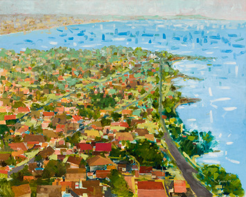 Bayside Gallery - Bayside City Council Art & Heritage Collection
Painting - oil on canvas, John Trebilco, Aerial view of Black Rock, 1978
boats, bay, water, half moon bay, black rock, bayside, john trebilco, aerial, houses, streets, coast, beaumaris, beach road -
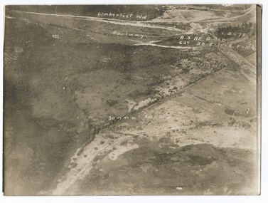 Melbourne Legacy
Photograph - Photo, Aerial view of the Somme
An aerial photo of the Somme Swamp in France during World War One. There are coordinates or numbers in some areas. Also labelled are the railway line and Canal du Nor and Limberlost Wood. Was with 11 other photos of World War One that had been mounted on board for display at Legacy House at some stage. When they were taken off display they were put in the archive cabinets. The founding legatees all served in World War One so these photos would have been of significant places for them. (see 01888 to 01899)Photos from World War One that would have been significant to the founding legatees.Sepia photo of the Somme battlefield in France during World War One.world war one, france, somme -
 Lakes Entrance Historical Society
Postcard - Omeo Victoria, H D Bulmer, 1940 c
Black and white postcard showing an aerial view of the roads and country surrounding the mining town of Omeo VictoriaAerial view of Omeohotels, transport -
 Lake Bolac & District Historical Society
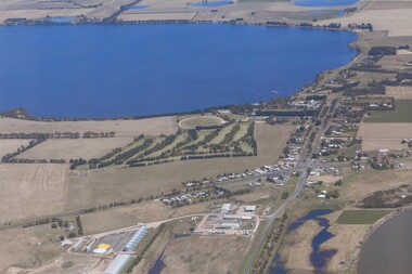
Colour photograph, Aerial view of Lake Bolac and village. After the rain, 2010
Aerial view of Lake Bolac after the drought had broken in late 2010. The fresh-water lake is now full, as are the wetlands. Note the edge of the salt-lake in the bottom right, the Industrial Estate bottom left and centre, the golf course, the current footy oval, Bowling Club, tennis courts and swimming pool with the P-12 College through the trees on the bank of the lake. An Archaeologist might be able to discern the original footy oval bottom centre, built on what was once the town Common (below the industrial buildings),and the second oval (above the salt lake.) The houses are spreading along the west bank of the lake beyond the school.lake bolac, 2010, village, fresh-water lake, salt lake, golf, tennis, bowling, swimming, college, -
Stawell Historical Society Inc
Photograph, Aerial Photos of Stawell from a Hot Air Balloon 1992 -- 12 Photos
Series of 12 Aerial Photos of Stawell. Hot Air Balloon, October 1992 1. Cnr. Maude St & Grant Street 2. Maude St Napier Street & Railway cutting 3. Trotting Track 4. Roundabout Wimmera & Sloane Street 5. Florence Street towards Cato Lake & Park 6. Grampians Range with Lake Lonsdale near center 7. Gold Reef Mall looking West 8. Church Street looking West 9. Looking towards Black Range 10. Moonie Dams Darlington Road Leisure Complex 11. Stawell Gold Mine Evaporations Dams, Stawell Water Reservoirs, Moonie Dams 12. Darlington Road looking towards Black RangeSeries of 12 colour photographs from the Air.stawell