Showing 230 items
matching aerial photography
-
 Phillip Island and District Historical Society Inc.
Photograph
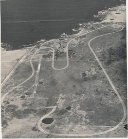
One of a collection of over 400 photographs in an album commenced in 1960 and presented to the Phillip Island & Westernport Historical Society by the Shire of Phillip IslandEarly aerial photograph of the Phillip Island Motor Race Track - c. 1960'slocal history, photography, phillip island motor race track, black & white photograph, phillip island race track, john jenner, bryant west -
 Phillip Island and District Historical Society Inc.
Photograph, 26/12/1920
One of a collection of over 400 photographs in an album commenced in 1960 and presented to the Phillip Island & Westernport Historical Society by the Shire of Phillip IslandPhotograph of Herald Newspaper clipping 26/12/1920, showing part of a photograph of the Bi Plane winner of "The Herald" Cup in Aerial Derby.local history, photography, herald newspaper clipping, black & white photograph, herald newspaper, herald cup, aerial derby, bi planes, john jenner, bryant west -
 Phillip Island and District Historical Society Inc.
Photograph, c. 1959
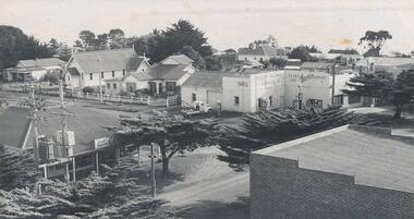
One of a collection of over 400 photographs in an album commenced in 1960 and presented to the Phillip Island & Westernport Historical Society by the Shire of Phillip IslandAerial photograph of the intersection of Thompson Avenue & Chapel Street showing General Store, Phillip Island Garage and Catholic Church.local history, photography, intersection thompson avenue & chapel street, cowes, black & white photograph, thompson avenue cowes, chapel street cowes, garages, churches, john jenner, bryant west -
 Bendigo Historical Society Inc.
Photograph - LA TROBE UNIVERSITY BENDIGO COLLECTION BENDIGO: TEACHERS' COLLEGE BUILDINGS
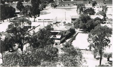
A black and white photograph of an aerial view from the Lookout Tower in Rosalind Park of Bendigo Teachers' College as it was in the 1950's. In the foreground are aluminium prefabs and the old police stables. In the background is the old gaol and over to the left are the tennis courts which appear to have the sprinklers on. Although it is out of view Camp Hill Primary School is on the right of the buildings. 1950's.bendigo, education, bendigo teachers' college, la trobe university bendigo collection, collection, education, tertiary education, bendigo, bendigo teachers' college, place, buildings, bendigo gaol, tennis courts, gaol, photo, photograph, photographs, photography -
 Tatura Irrigation & Wartime Camps Museum
Photograph, Aerial Photograph, Jan-59
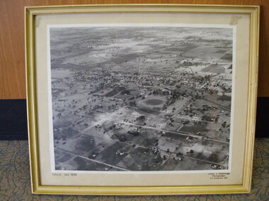
Framed enlarged aerial photograph of Tatura, January 1959.Tatura Jan 1959tatura, photography, photograph, slides, film -
 Lakes Entrance Historical Society
Photograph - Framed photograph, 2002c
Mounted on chipboard, rear of backboard has strap for wall hangingMounted photograph, aerial view of waterway and housing area from Kalimnaphotography, photographs, slides, film -
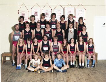 Stawell Historical Society Inc
Photograph, Mick Walsh, Mick Walsh Stawell Studio Colour Negatives, 1975 to 1986
Negatives from Stawell Photographer. Discarded from Penna Print Ararat. Son contacted and gave approval for Stawell Historical Society to keep them. Only those of a non personal nature scanned. Ken German David Read Motors Graeme Healy Family Ann French Doug Cross Family Vikki & John Holcombe Family Kaye Ellen Family Jenkins Hand Heather Slorach & Rod Reading Pencker Family Pigeons Ian Bryant Linda Clarke & Hank Woldhuis Philip West Aerial Photos Mrs L Fielding 80th Show 1980 Lindsay Flowers Harrisons Wedding Cake Debbie Martin & Bob McGregor Rene Hall 80th Pool Game 1980 Mrs Coates 100th Ann Watson & Mike Farrell Glenda Smith & Geoff Lewin Nell Stewart & Liam Pickering SAAC 1980 Dadswells Stawell Brass Band Shuttleworth Dogs Helen Grace Cat Tina Walters Queens Scout Peel Family Trudy Harrison Grange Golf Slaughter House Suzanne Gercovitch & Gary Isbel Colour negatives of families, weddings and other. Nineteen Lever Arch Folders Mick Walsh 52 Patrick Street Stawellphotography -
Stawell Historical Society Inc
Photograph, Mick Walsh, Mick Walsh Stawell Studio Colour Negatives, 1975 to 1986
Negatives from Stawell Photographer. Discarded from Penna Print Ararat. Son contacted and gave approval for Stawell Historical Society to keep them. Only those of a non personal nature scanned. Cuffe Family Stawell Agricultural Show 1986 Stawell Show Aerials Streets Baby Jane Oram Baby Christening Kwiatek home Middleton Family Paintings Patricia Seeary Smith & Peatt Stawell Golf Bowles Irene Williams & John Towers Commonwealth Bank ANZ Bank Kath Pierce & Craig Hutchings Glenthompson Jende Baby Christening Pomonal Mrs Kuhne Jende Baby L Skurrie Family Mrs Coombs Copies Skurrie Children Buckingham Car Christmas tables at Old Courthouse Ruth Clark Poster Kaye Cunningham & Wade Kindred Cahill & Taylor Mullane Family Goodwin copies Geo Cox copies Watkins Grave dedication Mr & Mrs Ern Anderson Briggs Baby Reg Pigeons Mrs Garry Middleton Muller baby Eliz Chapman & John Shrimpton Colour negatives of families, weddings and other. Nineteen Lever Arch Folders Mick Walsh 52 Patrick Street Stawellphotography -
 Ballarat Heritage Services
Painting - Artwork, Lisa Gervasoni, Yandoit Creek Summer Oblique ,2021, 2021
Interpretation of the Gervasoni farms at Yandoit Creek using a fauvist colour palette.Lisa J. GERVASONI Born Melbourne, Victoria Graduating from Royal Melbourne Institute of Technology where she received a Bachelor of Applied Science-Planning, and the University of Melbourne with a Master of Environmental Studies Lisa Gervasoni's artwork reflects her passion for the landscape and built form. Lisa Gervasoni specialises in photography, embroidery and acrylic paintings on canvas. Many of her works have the theme of interpretation of heritage and cultural spaces. Dedicated to recording cultural heritage in situ Lisa Gervasoni has used photography to document urban areas, heritage sites and natural resources of Australia.She has provided over 70,000 images to the National Library of Australia Trove database via the Flickr portal. In 2004 Lisa Gervasoni won the Daylesford Small Art Prize for an embroidered depiction of the Savoia Hotel in Hepburn Springs, and in 2022 she was shortlisted in the Harden Landscape prize. Her art mediums are photography, embroidery and acrylic on canvas. Many of her works have a theme of interpretation of heritage and cultural spaces. abstract, modernPainted stretched canvas depicting an abstract aerial oblique of Yandoit Creek, Victoria.gervasoni farm yandoit creek, lisa gervasoni, yandoit creek, italo-australians -
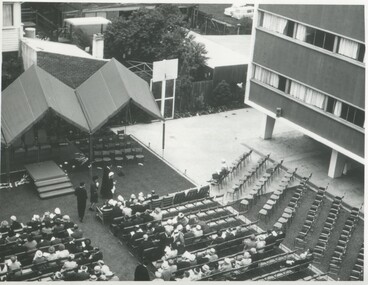 International House, The University of Melbourne
Photograph (Item), Aerial view of the official opening of the Samuel Wadham Wing at International House, 1963
The Samuel Wadham Wing was the second purpose-built accommodation building at International House at the University of Melbourne. The building was officially opened by Lord Richard Casey (1890–1976) on 23 March 1963. -
Kew Historical Society Inc
Journal, Kew Historical Society, Newsletter No.107, June 2014
... [aerial photography] / Robert Baker p1. Society Activities ...Kew From Above [aerial photography] / Robert Baker p1. Society Activities: Exhibitions [Kew From Above, Model Kew Kitchen of the 1920s]; Quarterly book sale; New members; Past meetings; Recognition for Dorothy Benyei [archivist]; Future meetings; Tribute [Millicent Lindsay] / p3. National Bank of Australasia 'Signature Books' / Robert Baker p4 The Salvation Army in Kew / p5. Uncovering a hidden house ['Mount Eri', 9 Highbury Grove] / Robert Baker p5. Council Family Hotel / Robert Baker p6-7 New acquisitions / Robert Baker p7. 'Coonoor', 85 Studley Park Road / Kerry Fairbank p8-10. News from the past [150-years ago, 100-years ago]/ p10. Support Kew's History / p11. Ordsall-Southesk / Robert Baker / p12Published quarterly since 1977, the newsletters of the Kew Historical Society contain significant research by members exploring relevant aspects of the Victorian and Australian Framework of Historical Themes. Frequently, articles on people, places and artefacts are the only source of information about an aspect of Kew, and Melbourne’s history.non-fictionKew From Above [aerial photography] / Robert Baker p1. Society Activities: Exhibitions [Kew From Above, Model Kew Kitchen of the 1920s]; Quarterly book sale; New members; Past meetings; Recognition for Dorothy Benyei [archivist]; Future meetings; Tribute [Millicent Lindsay] / p3. National Bank of Australasia 'Signature Books' / Robert Baker p4 The Salvation Army in Kew / p5. Uncovering a hidden house ['Mount Eri', 9 Highbury Grove] / Robert Baker p5. Council Family Hotel / Robert Baker p6-7 New acquisitions / Robert Baker p7. 'Coonoor', 85 Studley Park Road / Kerry Fairbank p8-10. News from the past [150-years ago, 100-years ago]/ p10. Support Kew's History / p11. Ordsall-Southesk / Robert Baker / p12kew historical society (vic.) -- periodicals., kew historical society (vic.) -- newsletters, kew historical society (vic.) -- journals -
 8th/13th Victorian Mounted Rifles Regimental Collection
Photograph - Aerial photograph desert column
... melbourne Example of aerial photography during WWI in Middle East ...Example of aerial photography during WWI in Middle East.Black and White aerial photograph of column of horses in desert terrainmilitary, wwi, world war one, desert, horses, aerial -
 Port Fairy Historical Society Museum and Archives
Photograph, c. 1925
... Street Port Fairy great-ocean-road Black and white aerial ...Black and white aerial of Martins Point Moyne River showing dredge. The original signed by R. W. Golding.Black and white landscapelocal history, photography, photographs, slides, film, aerial, martins point, moyne river, dredge -
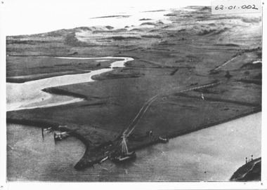
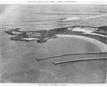 Port Fairy Historical Society Museum and Archives
Photograph, C. 1925
Black and white arial photograph of the Moyne river entrance, the original signed by R.W.Golding.Black and white aerial photograph of Griffith island showing the lighthouse keeper’s compound, the large flagstaff and the river training walls in the foregroundHand written on the back "Port Fairy Moyne River Entrance R. W. Golding Handwritten on the back of the copy "Port Fairyb Harbour 1925"local history, photography, photographs, slides, film, arial, moyne river -
 Bendigo Military Museum
Photograph - 4th Field Survey Squadron deployed on Operation NERIGHT, Queensland & Northern Territory, 1989
This is a set of 19 photographs taken in 1989 during 4th Field Survey Squadron’s deployment on Operation NERIGHT 89 in Queensland and the Northern Territory. It was a two-part operation in 1989 with work conducted in the areas of Camooweal and Weipa. Part 1 was the field completion of topographic maps conducted near Camooweal QLD, along the Barkley Highway on the border between NT and QLD, from the 12th of September to the 20th of October 1989. A Bell Kiowa LOH helicopter from 162 Recce Sqn supported topographic field completion. Operation NERIGHT 89 Part 2 was the acquisition of mapping control by GPS field parties utilising Texas Instruments TI4100 Global Positioning System receivers around Weipa on Cape York Peninsula from the 22nd of September to the 22nd of October 1989. Part 2 Two Bell UH-1H Iroquois helicopters from RAAF’s 35 Squadron were principally used to deploy GPS field parties. Identification photography of control points was taken by air camera operators in AAAvn Pilatus Porter aircraft from 173 Gen Spt Sqn fitted with an RC10 aerial camera. The two parts of the operation were conducted concurrently. This is a set of 19 photographs taken in 1989 during 4th Field Survey Squadron’s deployment on Operation Neright in Queensland & the Northern Territory. The colour photographs are on 35mm negative film and are part of the Army Survey Regiment’s Collection. The photographs were scanned at 96 dpi. .1) to .3) - Photo, colour, 1989. En-route to areas of survey operations. .4) to .5) - Photo, colour, 1989. Unidentified personnel relax next to river/waterhole. .6) - Photo, colour, 1989. Two Bell UH-1H Iroquois helicopters from RAAF’s 35 SQN utilised in the movement of GPS parties. .7) to .9) - Photo, colour, 1989. Unidentified soldier practices repelling from a UH1H Iroquois helicopter. .10) - Photo, colour, 1989. Inside the cockpit of a UH1H Iroquois helicopter. .11) - Photo, colour, 1989. Field Party camp with GPS equipment in foreground. Unidentified soldier prepares a meal. .12) - Photo, colour, 1989. GPS antenna plumbed over a survey ground mark. Witness post on left. .13) & .14) - Photo, colour, 1989. Unknown Cape York Peninsula beaches. .15) & .16) - Photo, colour, 1989. Dramatic fire next to base camp. .17) - Photo, colour, 1989. Aboriginal rock art at unknown location. .18) - Photo, colour, 1989. Aboriginal rock art at unknown location. L to R: unidentified, SPR Andrew Quin. .19) - Photo, colour, 1989. Aboriginal rock art at unknown location. LT Chris Topovsek..1P to .19P – There are no personnel identified. ‘1989 OP NERIGHT’ annotated on negative sleeve.royal australian survey corps, rasvy, 4 fd svy sqn, op neright 89 -
 Bendigo Military Museum
Photograph - 4th Field Survey Squadron – Operation ARIGHT 93, Queensland, 1993
This is a set of 42 photographs taken during 4th Field Survey Squadron’s deployment on Operation ARIGHT 93 in North Queensland from the 30th of August to the 8th of October 1993. The Survey Field Completion area of operations was Weipa near the top end of the Cape York Peninsula. Survey parties conducted field checking of topographic maps covering Bamaga, Heathlands, Weipa, Lockhart River and Strathgordon in Perentie 110 Series Survey variant FFR Land Rovers. Hand-held Trimble and Magellan GPS receivers were used to assist with navigation and to position remote isolated features. Three Bell Kiowa LOH helicopters provided by 162 Recce Sqn supported field checking operations. Supplementary and Vital Asset Protection photography was taken by air camera operators in AAAvn Nomad aircraft from 173 Survl Sqn fitted with an RC10 aerial camera.This is a set of 42 photographs taken in 1993 durin8g 4th Field Survey Squadron’s deployment on Operation ARIGHT in North Queensland. The colour photographs are on 35mm negative film and are part of the Army Survey Regiment’s Collection. The photographs were scanned at 96 dpi. .1) - Photo, colour, 1993. Survey party in Perentie 110 Series Land Rover navigates through Cape York Peninsula sand hills. .2) - Photo, colour, 1993. Cape York Peninsula sand hills. .3) - Photo, colour, 1993. Cape York Peninsula Island. .4) - Photo, colour, 1993. Survey party in Perentie 110 Series Land Rover enters a Cape York Peninsula beach. .5) - Photo, colour, 1993. SPR Kim Baker takes a break on a Cape York Peninsula beach. .6) - Photo, colour, 1993. L to R: MAJ Andy Cordova (USA Exchange) from the Army Survey Regiment and unidentified civilians. .7) to .14) - Photo, colour, 1993. Cape York Peninsula topography. .15) - Photo, colour, 1993. Unidentified surveyor in Bell Kiowa LOH helicopter. .16) - Photo, colour, 1993. Bell Kiowa LOH helicopter circles base camp. .17) to .18) - Photo, colour, 1993. Cape York Peninsula topography. .19) - Photo, colour, 1993. Vehicle convoy taking a break. L to R: LT John Bath (Detachment OC), unidentified (x2), SPR Chris Pearse. .20) - Photo, colour, 1993. Vehicle convoy taking a break. .21) - Photo, colour, 1993. Vehicle convoy ready to go. SPR Chris Pearse. .22) - Photo, colour, 1993. Vehicle convoy on the move. .23) - Photo, colour, 1993. Cape York Peninsula topography. .24) - Photo, colour, 1993. Unidentified personnel. .25) - Photo, colour, 1993. SGT Neale ‘Tex’ Houston. .26) - Photo, colour, 1993. Ground below a Bell Kiowa LOH helicopter .27) - Photo, colour, 1993. L to R: SPR Mark Sinderberry and CPL Stuart Adrain in a Bell Kiowa LOH helicopter. .28) & .29) - Photo, colour, 1993. Ground below a Bell Kiowa LOH helicopter. .30) - Photo, colour, 1993. Base camp viewed from a Bell Kiowa LOH helicopter. .31) - Photo, colour, 1993. Cape York Peninsula topography in recovery after burn-off. .32) & .33) - Photo, colour, 1993. SPR Kim Baker contemplates crossing this bridge in his Land Rover. .34) - Photo, colour, 1993. SPR Kim Baker takes a break next to a billabong. .35) - Photo, colour, 1993. Survey party in Perentie 110 Series Land Rover crosses a creek. .36) - Photo, colour, 1993. Cape York Peninsula bush fire in distance. .37) - Photo, colour, 1993. Survey party in Perentie 110 Series Land Rover traverses a sand hill. .38) - Photo, colour, 1993. SPR Kim Baker. .39) - Photo, colour, 1993. Cape York Peninsula bush fire. .40) - Photo, colour, 1993. Cape York Peninsula topography. .41) & .42) - Photo, colour, 1993. Cape York Peninsula sand hills..1P to .42P – There are no personnel identified. ‘1993 OP ARIGHT’ annotated on negative sleeve.royal australian survey corps, rasvy, 4 fd svy sqn, op aright 93 -
 Bendigo Military Museum
Photograph - 4th Field Survey Squadron – Operation NERVOSE 85 Field Phase Oblique Photos, NT, 1985
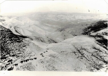
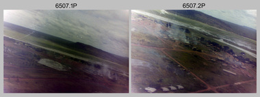
This is a set of 20 oblique aerial photographs taken during the field phase of 4th Field Survey Squadron’s Operation NERVOSE 85 project in the Northern Territory in 1985. Operation NERVOSE 85 was mounted by 4 Fd Svy Sqn in the EAST ARNHEM, VICTORIA RIVER DOWNS AND DALY WATERS areas of the Northern Territory from 26 May to 18 Sep 85. The aim of Operation NERVOSE 85 was to finalise the horizontal and vertical control for mapping at a scale of 1:50,000, to field check 40x 1:50,000 preliminary maps and to obtain mapping photography in support of the RAAF TINDAL redevelopment project. *Note –These photos were most likely taken in 1985, contrary to the ‘1987’ date annotated on the negative sleeves. The Op NERVOSE 85 Project Report available on RASVY’s web site lists a nominal roll of personnel. Photos of 4 Fd Svy Sqn taken in 1985 and 1987 provide names of posted personnel. Several personnel identified in these photos were posted to 4 Fd Svy Sqn in 1985, not in 1987. See items 6504.13P, 6505.28P and 6506.16P for more photos taken prior to and during Operation NERVOSE 1985. This is a set of 20 oblique aerial photographs taken during the field phase of 4th Field Survey Squadron’s Operation NERVOSE 85 project in the Northern Territory in 1985. The colour photographs on 35mm negative film and are part of the Army Survey Regiment’s Collection. The photographs were scanned at 96 dpi. .1) to .20) - Photo, colour, 1985. Unknown locations..1P to .20P – There are no personnel identified. ‘1987 OP NERVOSE VICTORIA RIVER DOWNS AND DALY WATERS.’ annotated on negative sleeve.royal australian survey corps, rasvy, 4 fd svy sqn, op nervose 85 -
University of Melbourne, Burnley Campus Archives
Plan, Wilsons Promontory8119-I and Glennie 8119-IV, 1971
State Aerial Survey Plan of Wilsons Promontory and Glennie. Dated 1971. Provisional Compilation of Sheets 8119-I and 8119-IV from Commonwealth Department of National Development Photography for the Department of Crown Lands and Survey Victoria. Students made excursions to Wilsons Promontory.wilsons promontory, glennie group, anser group, bass strait, aerial survey -
 Bendigo Military Museum
Photograph - 4th Field Survey Squadron – Operation ARIGHT 91, Queensland, 1991
This is a set of 16 photographs taken during 4th Field Survey Squadron’s deployment on Operation ARIGHT 91 in Queensland from the 8th of July to the 5th of September 1991. The area of operations was the top end of the Cape York Peninsula, islands of the Torres Strait and the southern coast of PNG. Field parties utilised Texas Instruments TI4100 Global Positioning System receivers. Concurrent with GPS operations Doppler point positioning observations were carried out by field parties using Magnavox MX 1502 receivers on six of the control points. Two Bell UH-1H Iroquois helicopters from RAAF’s 171 COMD and Liaison Squadron were primarily used to deploy GPS field parties. Identification photography of control points was taken by air camera operators in AAAvn Pilatus Porter aircraft from 173 Gen Spt Sqn fitted with an RC10 aerial camera.This is a set of 16 photographs taken in 1991 during 4th Field Survey Squadron’s deployment on Operation ARIGHT in Queensland. The colour photographs are on 35mm negative film and are part of the Army Survey Regiment’s Collection. The photographs were scanned at 96 dpi. .1) to .3) - Photo, colour, 1991. Area of Operations (AO) coordination maps. .4) - Photo, colour, 1991. GPS acquisition post-processing. L to R: LT Simon Buckpitt, SSGT Steve Winner, WO2 Ken Talbot-Smith. .5) to .6) - Photo, colour, 1991. Base camp unidentified personnel. .7) - Photo, colour, 1991. L to R: OPS WO - WO2 Ken Talbot-Smith, DET SSM WO1 Stevo Hinic. .8) - Photo, colour, 1991. Base camp unidentified personnel. .9) - Photo, colour, 1991. Base camp L to R: unidentified (x2), OPS WO - WO2 Ken Talbot-Smith. .10) - Photo, colour, 1991. Base camp unidentified soldier. .11) - Photo, colour, 1991. Base camp L to R: CPL Andy Love, unidentified, SGT Steve McGuiness. .12) - Photo, colour, 1991. Base camp at Horn Island Army Compound. .13 to .16) - Photo, colour, 1991. Unknown locations in Area of Operations..1P to .16P – There are no personnel identified. ‘1991 OP ARIGHT’ annotated on negative sleeve.royal australian survey corps, rasvy, 4 fd svy sqn, op aright 91 -
 Phillip Island and District Historical Society Inc.
Photograph, 1920
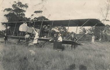
Rhylston Park, an Italianate villa, was built in 1886 and the home of Mr Vaughan. One of a collection of over 400 photographs in an album commenced in 1960 and presented to the Phillip Island & Westernport Historical Society by the Shire of Phillip IslandPhotograph of an aeroplane and the first aerial bread delivery in Australia at Rhylston Park, Cowes, Phillip Island about 1920local history, photography, aeroplane, bread delivery, black & white photograph, air transport, john jenner, bryant west