Showing 762 items
matching aerial views
-
 Kew Historical Society Inc
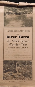
Flyer, Melbourne Ferries Pty Ltd, River Yarra: 20 Miles Scenic Wonder Trip
... scenic wonder trip. Aerial view over Dight’s Falls on front. .... Aerial view over Dight’s Falls on front. Harding's (aka Melbourne ...Bifold brochure including route map of the full 44 mile 'Wonder Trip' on pages 2 & 3. Photos used include an 'Aerial view over Dight's Falls', two ferries, and a 'Scene near Dight's Falls'.Flyer for Harding’s Launches on the River Yarra: 20 miles scenic wonder trip. Aerial view over Dight’s Falls on front. non-fictionBifold brochure including route map of the full 44 mile 'Wonder Trip' on pages 2 & 3. Photos used include an 'Aerial view over Dight's Falls', two ferries, and a 'Scene near Dight's Falls'.river yarra, melbourne ferries pty ltd, yarra river -- tourism, harding's cruises, christian-washfold collection -
 Port Melbourne Historical & Preservation Society
Postcard - John Kitchen series, aerial view of J Kitchen & Sons Pty Ltd, David Thompson et al, Nov 1916
... John Kitchen series, aerial view of J Kitchen & Sons Pty... - black and white aerial view of J Kitchen & Sons site... Street) Port Melbourne melbourne John Kitchen series, aerial view ...PMHPS - John Kitchen series of six coloured postcards .03 - black and white aerial view of J Kitchen & Sons siteindustry - manufacturing, business and traders - soaps/candles, built environment - industrial, j kitchen & sons pty ltd -
 South Gippsland Shire Council
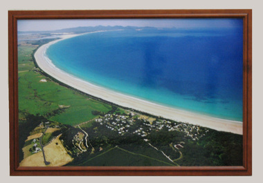
Photograph, Framed, 2003
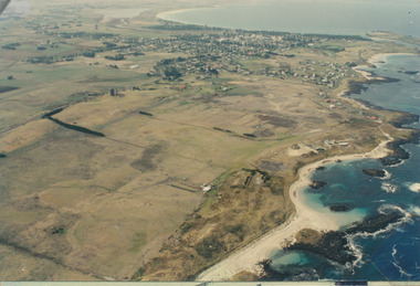
... Framed colour photograph featuring an aerial view... an aerial view of Waratah Bay, the beach and Sandy Point . Wilsons ...Framed colour photograph featuring an aerial view of Waratah Bay, the beach and Sandy Point . Wilsons Promontory can be seen in the distance. -
Glenelg Shire Council Cultural Collection
Photograph - Photograph - aerial view of Portland, 1970
... Photograph - aerial view of Portland...Black and white aerial view of central Portland 1970. Image... Cliff Street Portland great-ocean-road Photograph - aerial view ...Black and white aerial view of central Portland 1970. Image depicts residential areas in foreground and Portland Harbour in background. Framedaerial photography, central portland, portland harbour, residential -
 City of Kingston
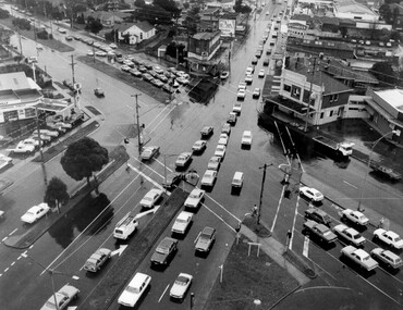
Photograph - Black and white, c. 1950
... Black and white photograph with an aerial view...: 150% Black and white photograph with an aerial view ...The image shows a line of traffic travelling along South Road in response to traffic light signlas while an increasing number of cars are banking up along Nepean Highway, also in response to traffic light signals.This image provides a strong contrast to images from earlier eras of the same intersection. The amount of traffic has increased enormously as well as commercial development.Black and white photograph with an aerial view of the intersection of Nepean Highway and South Road, taken from above the Moorabbin Council Chambers.Handwritten in black ink Pic [indecipherable] / 1000 Handwritten in red ink: 150%moorabbin, traffic lights, cars, nepean highway -
 Stawell Historical Society Inc
Photograph, Stawell Aerial View 1969
... Stawell Aerial View 1969...Aerial View of Stawell 1969... grampians Photograph Stawell Aerial View 1969 Aerial View of Stawell ...Aerial View of Stawell 1969stawell -
 Stawell Historical Society Inc
Photograph, Stawell Hospital -- Aerial view
... Stawell Hospital -- Aerial view ...Aerial view of Stawell Hospital...Photograph Stawell Hospital -- Aerial view Aerial view ...Aerial view of Stawell Hospitalstawell hospital -
 Port Fairy Historical Society Museum and Archives
Photograph
... Aerial view of Port Fairy West... aerial photograph Aerial view of Port Fairy West sand hill ...Aerial view of Port Fairy WestColoured aerial photographsand hill cemetery, water tower, west -
 Stawell Historical Society Inc
Photograph, Stawell Water Supply -- Aerial View -- Coloured
... Stawell Water Supply -- Aerial View -- Coloured...Aerial view of Stawell Water Supply... grampians Photograph Stawell Water Supply -- Aerial View -- Coloured ...Aerial view of Stawell Water Supplystawell -
Stawell Historical Society Inc
Photograph, Stawell Aerial View 1992 -- Colour
... Stawell Aerial View 1992 -- Colour...Colour Aerial View of Stawell 1992... grampians Photograph Stawell Aerial View 1992 -- Colour Colour ...Colour Aerial View of Stawell 1992stawell -
 City of Ballarat Libraries
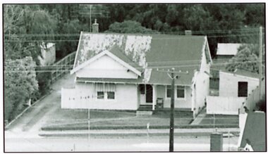
Photograph - Card Box Photographs, Queen Elizabeth Geriatric Centre, Ballarat circa 1945
... Aerial view of the QEGC on Ascot Street.... Elizabeth Geriatric Centre, Ballarat circa 1945. Aerial view ...Aerial view of the QEGC on Ascot Street.queen elizabeth geriatric centre, qegc, ballarat, ascot street, building, public building, medical -
Port Fairy Historical Society Museum and Archives
Photograph
... Aerial view across the Moyne river ... view across the Moyne river aerial moyne river martin's point ...Aerial view across the Moyne river Black and white photograph of Martins Point, river moyne and the pudney grounds from the air aerial, moyne, river, martin's point, port fairy, barge, dredge, pudney ground, griffith island -
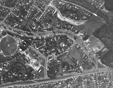 Ringwood and District Historical Society
Photograph, Aerial view showing East Ringwood oval, Mount Dandenong Road, and Civic Centre, Braeside Avenue/Maroondah Hwy, c.1970
... Aerial view showing East Ringwood oval, Mount Dandenong...Aerial view showing East Ringwood oval, Mount Dandenong... Road Ringwood North melbourne Photograph Aerial view showing ...Aerial view showing East Ringwood oval, Mount Dandenong Road, and Civic Centre, Braeside Avenue/Maroondah Hwy, c.1970. -
Tatura Irrigation & Wartime Camps Museum
Photograph - copy, 1988
... Colour photograph of a painting by Luise Katz. Aerial view... of a painting by Luise Katz. Aerial view of Tatura Internment camp ...Tatura Internment camp built during WW2. For German POW's. Photographs taken at exhibition of camp memorabilia displayed at Templers Home for Aged, Bayswater, Victoria, in 1981Colour photograph of a painting by Luise Katz. Aerial view of Tatura Internment camp showing areas A, B, C and D. Negative no. 16.german pow's, tatura, internment camps, ww2 -
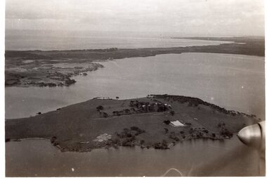 Churchill Island Heritage Farm
Aerial Photograph of Churchill Island
... Black and White photograph showing an aerial view... of Churchill Island Black and White photograph showing an aerial view ...Black and White photograph showing an aerial view of Churchill Island with Phillip Island in the background. A propeller is visible in the bottom right corner of the photograph.Catalogue number written in pencil on the reverse. 'S19' written in pencil on reverse. 'Kodak Print' stamped on reverse twice. 'VELOX' stamped diagonally on reverse. churchill island, aerial photography -
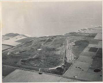 Phillip Island and District Historical Society Inc.
Photograph, J D Payens, Aerial photo of Grand prix track and painting of 1932 Grand Prix
... Black & White aerial view of the Phillip Island Grand Prix... and painting of 1932 Grand Prix Black & White aerial view ...The Circuit was built in the 1950's and opened in 1956. The circuit was closed in 1962 due to lack of finance for repair work to the track. In 1964 Len Lukey purchased the cirtuit and reopened in 1967, but once again was closed in 1978 as not suitable for modern racing. It was used only for Historic Rallies and the like until 1982. In 1985 The Circuit was purchsed by Placetac Pty Ltd. The Circuit was refurbished in 1988. In 1989 The Australian Motorcycle Grand Prix - 1st World Championship Round - was held at the Circuit on 9th April. 2004 the Circuit and surrounding land was purchased by The Linfox Group who still own it to this day (8/10/2016).Black & White aerial view of the Phillip Island Grand Prix Race Track with Bass Strait in the background and painting of 1932 Grand PrixJ. D. Payne - Commercial Photographer, Rice Street, Moorabbin. Phone: XL 3144phillip island g p circuit, grand prix circuit phillip island, len lukey, linfox group, jean parle, bill thompson, keith riordan, bugatti, 1932 grand prix -
Glenelg Shire Council Cultural Collection
Photograph, Aerial view of North West Portland, 1968
... Aerial view of North West Portland...Black and white photograph. Aerial view of North West... Aerial view of North West Portland Black and white photograph ...Port of Portland Authority archives.Front: (no inscriptions) Back: WOOL STORES & T.B + S AT NORTH PORTLAND/ PORTLAND HARBOUR TRUST COMMISSIONERS/ JAN 1968port of portland, wool stores, thomas borthwick -
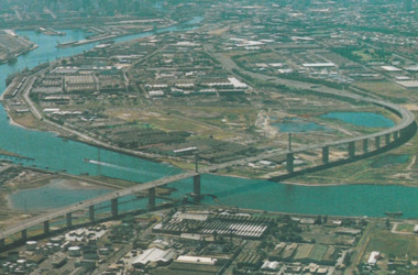 Port Melbourne Historical & Preservation Society
Postcard - Aerial view of West Gate Bridge, c. 1985
... Aerial view of West Gate Bridge...Colour postcard showing a photographed aerial view... aerial view of the West Gate Bridge. Also visible is the aircraft ...Colour postcard showing a photographed aerial view of the West Gate Bridge. Also visible is the aircraft factory and the industrial area of Fishermens Bendwest gate bridge, engineering - bridges, built environment - industrial, fishermans bend -
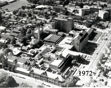 Ballarat Base Hospital Trained Nurses League
Aerial View of Ballarat Base Hospital, 1972
... Aerial View of Ballarat Base Hospital, 1972...aerial view...Aerial View of Ballarat Base Hospital, 1972... Street Nth Ballarat goldfields Aerial View of Ballarat Base ...Aerial View of Ballarat Base Hospital, 1972Shows all hospital buildings including the Nurses HomePhoto - black & whitenurses, home, 1972, aerial view, ballarat, hospital -
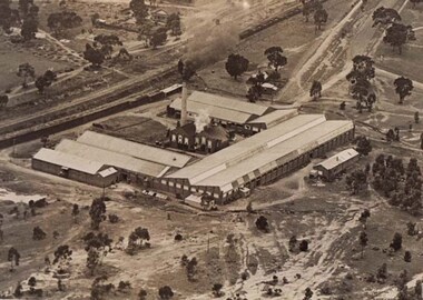 Stawell Historical Society Inc
Photograph, North Western Woollen Mills -- Aerial View
... North Western Woollen Mills -- Aerial View...North Western Woollen Mills Aerial View... grampians Photograph North Western Woollen Mills -- Aerial View ...North Western Woollen Mills Aerial Viewstawell industry -
Stawell Historical Society Inc
Photograph, North Western Woollen Mills -- Aerial View
... North Western Woollen Mills -- Aerial View...North Western Woollen Mills Aerial View... grampians Photograph North Western Woollen Mills -- Aerial View ...North Western Woollen Mills Aerial Viewstawell industry -
 Greensborough Historical Society
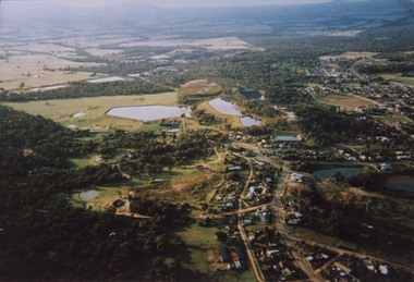
Slide - Photograph, John Ramsdale, Aerial view of Plenty River: Slide 16, 1990s
... Aerial view of Plenty River: Slide 16...Photograph shows aerial view of the Plenty River....Photograph Slide Aerial view of Plenty River: Slide 16 ...Photograph shows aerial view of the Plenty River.Part of the John Ramsdale collection of slides and audio visual material.Colour photograph scanned from slide.No maker's marks. No caption on slide.plenty river, aerial photograph -
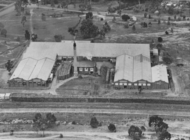 Stawell Historical Society Inc
Photograph, North Western Woollen Mills -- Aerial View, Duplicate of Framed Image
... North Western Woollen Mills -- Aerial View, Duplicate of...North Western Woollen Mills Aerial View...Photograph North Western Woollen Mills -- Aerial View ...North Western Woollen Mills Aerial Viewstawell industry -
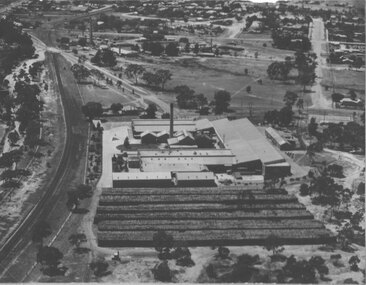 Stawell Historical Society Inc
Photograph, North Western Woollen Mills -- Aerial View, Duplicate of Framed Image
... North Western Woollen Mills -- Aerial View, Duplicate of...North Western Woollen Mills Aerial View...Photograph North Western Woollen Mills -- Aerial View ...North Western Woollen Mills Aerial ViewUnframed Copystawell industry -
Federation University Historical Collection
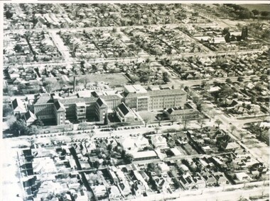
Photograph, Aerial View of the Ballarat School of Mines
... Aerial View of the Ballarat School of Mines...Aerial view of the Ballarat School of Mines showing... Photograph Aerial View of the Ballarat School of Mines Aerial view ...Aerial view of the Ballarat School of Mines showing the whole block surrounded by Lydiard Street South, Grant Street, Albert Street and Dana Street. ballarat school of mines, aerial -
 Ringwood and District Historical Society
Photograph, Aerial photograph of Heathmont, Victoria - c.1960s, 1975
... Aerial view of Heathmont - black and white photograph... of Heathmont, Victoria - c.1960s. Aerial view of Heathmont - black ...Aerial view of Heathmont - black and white photograph on chipboard backing. (Protected by slightly damaged plastic cover which could be removed for clearer image.)Department of Crown Lands and Survey Melbourne, Project Run 31A 27-12-1975, Lens 209 1951M ASL. -
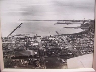 Glenelg Shire Council Cultural Collection
Photograph - Photograph - aerial view of Portland foreshore, 1970s
... Photograph - aerial view of Portland foreshore...Aerial view of Portland and foreshore. Black and white... Cliff Street Portland great-ocean-road Photograph - aerial view ...Aerial view of Portland and foreshore. Black and white photograph. Breakwater is on left, but part has only one domed building evident on far right.Front: (no inscriptions) Back: Twites Picture Framers, Carlton label.portland foreshore, harbour, coastal photography -
Glenelg Shire Council Cultural Collection
Photograph, View of Lady Bay reclaimation and Pivot Fertiliser Works, 21/03/1972
... Black and white photograph. Aerial view of Lady Bay... and white photograph. Aerial view of Lady Bay reclaimation, Pivot ...Port of Portland Authority archives.Front: (no inscriptions) Back: (no inscriptions)port of portland, lady bay, pivot fertiliser works -
Glenelg Shire Council Cultural Collection
Photograph, Aerial view of Cape Grant, n.d
... Aerial view of Cape Grant...Black and white photograph. Aerial view of Cape Grant... Aerial view of Cape Grant Black and white photograph. Aerial view ...Port of Portland Authority archives.port of portland, cape grant quarry -
Glenelg Shire Council Cultural Collection
Postcard - Postcard - Maretimo Portland, Victoria, n.d
... Coloured photo postcard, wavy edge. Aerial view.... Aerial view of 'Maretimo' historic home, Portland. view shows ...Coloured photo postcard, wavy edge. Aerial view of 'Maretimo' historic home, Portland. view shows main house and outbuilding plus gardensFront: 'Maretimo', PORTLAND, VICTORIA' printed in bright pink, top right Back: 'Short history of Maretimo' printed in brown, top left