Showing 23016 items
matching alpine-shire
-
 Stawell Historical Society Inc
Photograph, Stawell Shire Hall 1866 -- 04 Photos -- Coloured
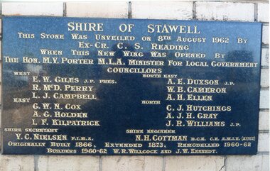
Shire Hall 4 Colour photos. Three photos (84.10a, b, c,) showing the brick veneer addition to the Stawell Shire Hall. One photo (84.10) of the plaque bearing the councillors names. These photos were taken in 2013 and each photo shows a different view of the brick veneer addition. One view is the front of the brick addition and other 2 are of the rear view of the 1962 addition.Four colour Photographs. Three of the brick additions to the Stawell Shire Hall in 1960-1962. One photograph of the plaque bearing the councillors names.Shire of Stawell. This stone was unveiled on 8th August 1962 by Ex. Cr. C. S. Reading When this new wing was opened by the Hon. M.V. Porter M.L.A. Minster for Local Government. Councillors WEST - E. W. Giles J.P. Pres., R. McD. Perry., L. J. Campbell., EAST - G. W. N. Cox., A. G. Holden., I.F. Kilpatrick., NORTH EAST - A. E. Duxson J.P., W.B. Cameron., A.H. Ellen., NORTH - C.J. Hutchings., A. J. H. Gray., J. R. Williams J.P., Shire secretary V. C. Neilson F.I.M.A. Shire Engineer N. H. Cottman B.C.E. C.E. A.M.I.E (Aust) Originally Built 1866. Extended 1873. Remodelled 1960-62 Builders 1960-62 W.R. Willcock and J.W. Kennedy.stawell -
 Linton and District Historical Society Inc
Report, Shire of Grenville, Engineer's Report re Gravel Heaps, 7th July 1916
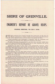
Single sheet approximately A4 in size, folded to form four pages. Three-page report prepared by M. Martin, Shire Engineer, detailing the advisability of and legal basis for the Shire of Grenville retaining control of various quartz and tailing heaps (remnants of mining) located throughout the Shire.Text: " SHIRE OF GRENVILLE. / ENGINEER'S REPORT RE GRAVEL HEAPS. / COUNCIL MEETING, 7th JULY, 1916. "shire of grenville, gravel heaps, mining, roads -
 Eltham District Historical Society Inc
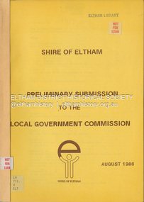
Document, Shire of Eltham, Shire of Eltham Preliminary submission to the Local Government Commission, August 1986
Report produced by the Shire of Eltham in August 1986 as a prelimary response to proposed municipal restructure in the state of Victorianon-fictionReport produced by the Shire of Eltham in August 1986 as a prelimary response to proposed municipal restructure in the state of Victoriacouncil amalgamation, annexation, rates -
 Falls Creek Historical Society
Letter - Accommodation During Victorian Alpine Championships
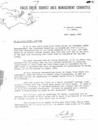
Bob (Herman) Hymans (a former member of the Royal Netherlands Navy) was born in Bloemendaal, Holland on 30th September 1922. During World War II he fought against the Japanese in the Dutch East Indies (now Indonesia) and was imprisoned in Changi and on the Burma Railway. After gaining qualifications as a Ski Instructor, Bob arrived in Falls Creek in July 1950. Working as an Instructor and Supervisor at Bogong Lodge, Bob decided his future was in accommodation. He was successful in negotiating an indenture for land from the State Electricity Commission (SEC). It took Bob two years to build his Grand Coeur Chalet but, tragically, it was burned down in August 1961. Bob also built the first Chairlift in Australia. This was a single chairlift and the structure was built from wooden electricity poles. He was constantly full of new ideas and proposals for the village. Bob Hymans died on 7th July 2007. This Collection of documents and letters tells the story of Bob's endeavours to develop Falls Creek into the ski village it is today.This letter is significant because it documents developments made or endorsed by the Falls Creek Tourist Area Management Committee.A letter from the Falls Creek Tourist Area Management Committee to all Licensees requesting support in an attempt to gain the right to stage the Victorian Alpine Championships in August 1963. In order to be successful an assurance of adequate availability of accommodation was needed. Licensees were asked to indicate how much accommodation they would have available as well as the number of persons they would have available to assist in the running of the event.falls creek tourist area management committee, falls creek administration, falls creek accommodation, ski championships -
 Greensborough Historical Society
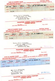
Financial record - Account, Shire of Diamond Valley, Shire of Diamond Valley rates notices 1969-1970, 26/03/1958
3 Shire of Diamond Valley Rates assessments issued jointly to Trevor and Gary Partington and their sisters, Mrs Elinor Rowe and Mrs Faye Fort. The locations of the land are Lot 41 Church Street and Lot 67 Scotland Avenue Greensborough. It is possible that this land was purchased by Alan Partington in his adult children's names.Part of the property owned by the Partington family in the original Greensborough farmland. 3 Rates notices, printed in red text with black typed details.Date stamped with rubber stampalan partington, william alan partington, partington family, land deals greensborough, church street greensborough, scotland avenue greensborough -
 City of Greater Bendigo - Civic Collection
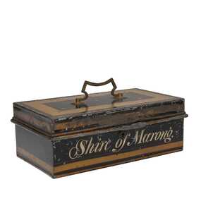
Functional object, Shire of Marong, Unknown
The first local government authority for Marong was the Marong Road District (an early form of single-purpose local government), which was proclaimed on 19 August 1860. Its boundary was altered twice in 1862 and on 12 December 1864 it was re designated as a shire. It absorbed Raywood Borough in 1915, and was proclaimed a Rural City in 1990. On 2 December 1994, with the creation of Greater Bendigo City Council, it was abolished by being amalgamated with Bendigo City, Eaglehawk Borough, Huntly Shire, part of McIvor Shire, part of Metcalfe Shire and Strathfieldsaye Shire to form Greater Bendigo City.Painted metal tin with handle on top. Currently locked closed.Shire of Marongshire of marong -
 Falls Creek Historical Society
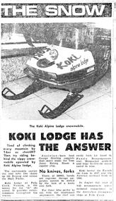
Article - Koki Alpine Lodge snowmobile
These items are from the private collection of George Shirling of Red Onion, Falls Creek. The article features the Koki Alpine Lodge Snowmobile. George Shirling arrived in Falls Creek in 1962. He engaged Phil Nowell to build the original Koki Alpine Lodge which opened in 1965 with 14 beds. George operated the lodge with Michael “Baldy” Blackwell as manager. He also graduated in sport psychology in 1981 and was invited to become team psychologist for the Australian Winter Olympic team which went to Albertville, France, in 1992. He later owned the Red Onion Chalet. George credited the success of Koki to “Baldy” Blackwell. “Baldy” and Phil Nowell started the Trackers Mountain Lodge in partnership during the 1980s. In 1971 George sold Koki Lodge to Sigi Doerr. In 2024 the renamed Koki Alpine resort remains a highly popular destination in Falls Creek. George Shirling passed away on 27th February 2023. He had remained actively involved in Falls Creek and was generous with his time and knowledge, always an amazing supporter of The Falls Creek Museum and Falls Creek Village.This article is significant because it features one of the innovations introduced by George Shirling at Falls Creek.An newspaper article featuring information about Koki Lodge and its innovative snowmobile.george shirling, falls creek, koki lodge -
 Rutherglen Historical Society
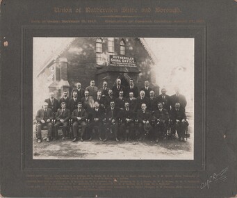
Photograph - Image, Alf L. Bowden, The Studio, Union of Rutherglen Shire and Borough, 1921
The building is the old Shire Hall (formerly a Church) in High Street. Roy Ready Senior bought the land and building and built his house with it as a part.Black and white photograph, mounted on cardboard, of a number of men in front of a building labelled Rutherglen Shire Office. Printed at top of mount: "Union of Rutherglen Shire and Borough | Date of Union: December 15, 1920. dissolution of Combined Councils: August 25, 1921." Complete list of individual names printed at bottom of mount. At bottom right of mount: "Alf L Bowden, The Studio, Corowa, N.S.W." Note from donor pasted on back of mount.rutherglen shire, rutherglen borough, shire buildings, rutherglen shire councillors, roy ready -
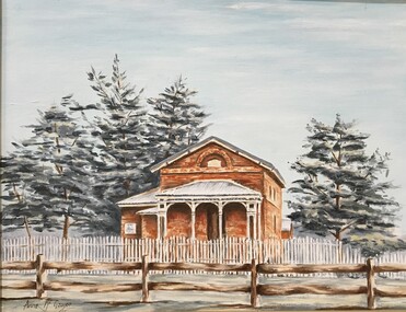 Pyrenees Shire Council
painting, Anne McGregor, Untitled (Lexton Shire), c1985
significant as a work of art by local Pyrenees artist, locally significant to the Central Highlands Region of Victoria as a representation of local landscape and/or culturelandscape with Lexton Shire OfficesAffixed front: Presented by Lexton's Anniversary Committee to the Lexton Shire Council IN RECOOGNITION OF IT'S VALUABLE SUPPORT & ASSISTANCE IN THIS, VICTORIA'S 150TH ANNIVERSARY YEAR 14-4-85 -
 Eltham District Historical Society Inc
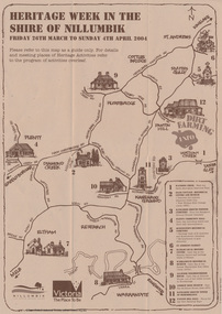
Booklet - Program, Shire of Nillumbik et al, Heritage Week in the Shire of Nillumbik, 2004
Map, with details of activitives presented by eight local history groups across the Shire of Nillumbik 26th March to Sunday 4th April 2004. Events included a dirt farming expo at Panton Hill. Program includes message by Mayor, Cr. Lex de Man and artwork by Syd Tunn. During the latter part of 2003 all of the historical societies and similar organisations in the Shire of Nillumbik attended a series of combined meetings arranged by Nillumbik Shire Council. The meetings were arranged by the Council's Arts and Cultural Services Co-ordinator and the Community Events Officer. ..The principal outcome of meetings ..to organise a Nillumbik Heritage Week to run from Friday 26th March to Sunday 4th April. The main event will be a combined heritage "expo" from 26th to 28th March, to be held in the Panton Hill Hall. The theme will be "Dirt Farming" which derives from the subsistence farming activities of the early settlers but could be widened to include gold mining, earth building and even modem day bushland regeneration. It fits well with the name "Nillumbik" which in the language of the Wurundjeri meant the not so good country covering most of our area and contrasted with the rich soil of the Kangaroo Grounds which they called Moor-rul. The following weekend each society will arrange their own separate activities. We intend to have open days at our Local History Centre on both days and this will include a display in the adjoining former Eltham Court House. We are also planning a heritage walk at 2.00pm on each day. Other groups will be having open days, displays, walks, guided car tours and other activities. - NL 154A3 sheet folded. Buff colour, with text and handrawn mapharry gilham collection, map, cultural heritage map, syd tunn, lex de man, eltham district historical society, nillumbik historical society, andrew ross museum, plenty historical society, st andrews queenstown historical society, warrandyte historical society, hurstbridge local history group -
 Ringwood and District Historical Society
Book, James Rouget, Shire of Lilydale Past and Present 1837-1923, 1924
See also "Ringwood, Place of Many Eagles - Hugh Anderson" for additional information on the separation of the Borough of Ringwood from Shire of Lilydale (p.154).Short history of the Shire of Lilydale including Ringwood, Croydon and surrounding districts prior to separation from Lilydale of Borough of Ringwood in 1924.Preface extract: This small Volume contains a short history of the Shire of Lilydale, and is designed as a record covering the period especially relating to the early settlement. ... The information herein recorded has been obtained from official sources, historical records, first hand knowledge, and from the Pioneers themselves ... -
 Orbost & District Historical Society
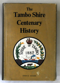
book, James Yeates & Sons, The Tambo Shire Centenary History, 1981
This is a local history of the Tambo Shire in East Gippsland. Tambo Shire (1882-1994) was created on 6 January 1882, by severance from Bairnsdale shire with Bruthen as the head . It was named after the Tambo River. Orbost Shire was originally a part of this shire as was Lakes Entrance. In 1994 Tambo shire was united with Bairnsdale city, Orbost and Omeo shires, most of Bairnsdale shire and part of Rosedale shire to form East Gippsland Shire.This book is a useful reference book on the history of the Tambo district.A 448 pp book with a gold coloured dust jacket with black print and an illustration of the Tambo Shire emblem 1882. It is titled " The Tambo Shire Centenary History".tambo-shire-history -
 Linton and District Historical Society Inc
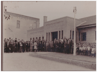
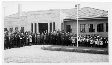
Photograph, Opening of Shire of Grenville Offices, 1939
Group of men, women and children standing in front of new Shire of Grenville Offices, which opened on March 30th, 1939. Mounted on grey/brown card.Reverse: "Shire Hall / Linton / March 30/1939".shire of grenville, offices, openings, buildings -
 Linton and District Historical Society Inc
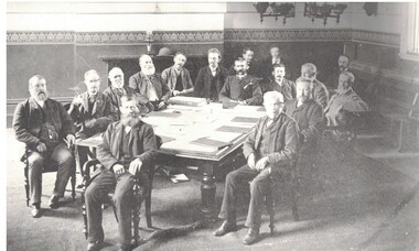
Photograph, Grenville Shire Council meeting c.1881
Understood to be a photograph taken during a Council meeting. Councillors are unidentified.Black and White copy of original photograph, which shows a group of men seated around a large table in the Council Chamber of the Shire of Grenville Town Hall.In pencil on back of photo: "Grenville Shire Council c1881".grenville shire council, councillors -
 Greensborough Historical Society
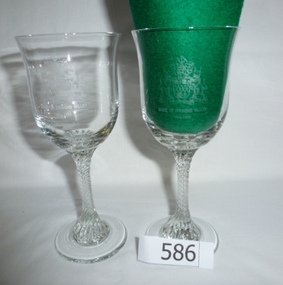
Glasses, Shire of Diamond Valley Commemorative glasses, 1994_
These glasses were distributed to commemorate the 30th anniversary of the proclamation of the Shire of Diamond Valley. The Shire of Diamond Valley was a Local Government Area located about 20 kilometres northeast of Melbourne. The shire covered an area of 74.38 square kilometres and existed from 1964 until 1994. A limited edition glass presented to community volunteers and others associated with the Shire of Diamond Valley.Pair of clear glass, stemmed wine glasses. Stem has spiral pattern.Etched into bowl "Shire of Diamond Valley 1964-1994" and shire coat of arms.shire of diamond valley, greensborough, commemorative glasses -
 Linton and District Historical Society Inc
Photograph, Taylors Super Snaps Ballarat, Opening of new Shire of Grenville offices, Linton 1939, 1939
The new Shire of Grenville Offices were officially opened on 29 March 1939.Black and white photograph of a crowd of people, adults and children, standing in front of a brick building."Shire open".shire of grenville, buildings, offices, sussex street linton, events, official openings -
 Bacchus Marsh & District Historical Society
Map, O'Hagan v Shire of Bacchus Marsh, Allotment 5, Sec 16, Parish of Korkuperrimul
The purpose for this map being created or the date when it was made has not been established. It appears to be documentation relating to a legal dispute by a landowner named O'Hagan and the Shire of Bacchus Marsh. Features identified on the map are allotment 5, section 16, Parish of Korkuperrimul, a 'cultivation paddock', a section of the Werribee River, the path of a section of a 'Main Channel', and a barrier or filled in section across the Werribee River called 'Lee's Filling'. The O'Hagan is likely to be Patrick O'Hagan, 1829-1914 who arrived in Bacchus Marsh in 1864 and was a prominent citizen and landowner in the area for many years until his death in 1914.Single page map showing allotment 5, section 16 in the Parish of Korkuperrimul, Scale 4 chains to inch. Part of a set of maps which are pasted into a bound volume containing 76 maps or plans in total. High resolution digital image stored on BMDHS computer network. Stamped: Munzt, Bace and Muntz, Civil Engineers and Licensed Surveyors , 388 Collins Streetbacchus marsh victoria maps, water supply structures and establishments, watercourses -
 Kiewa Valley Historical Society
Maps - Bogong x2, Tawonga, Omeo, Dargo, Victoria and others, 1. Bogong Alpine Area; 2. Bogong 8324; 3. Tawonga Topographical; 4. Omeo 8433; 5. Dargo 8323; 6. Victoria State
1. Bogong Alpine Area (outdoor Leisure Map. survey & Mapping Victoria, Government of Victoria, Edition 2, reprinted 1991 with an image of Mt. Feathertop on the front. Information for tourist in the Alpine National Park: Bogong Area. Including: recreational activities, history, weather and vegetation and a list of walks together with locality maps and photographs. The front cover has an image of Mt Feathertop against a blue sky with yellow writing 'Bogong Alpine Area', there is a yellow triangular block on the right hand top corner with black writing 'Outdoor Leisure Map. On the bottom edge is a block of yellow with black writing 'Survey & Mapping Victoria' and a light green map of Victoria with 'VICMSP' printed in white. 2. 8324 Bogong Victoria, Edition 1, Commonwealth of Australia 1981. A topographical Map: 1:100,000 scale (1 cm to 1 KM). Map has a red cover with white writing together with a white block and black writing and a map insert. 3. Tawonga Topographical Map - Forests Commission Victoria, / revised 5/9/77, DEG No. 68-G/399. A Tawonga 803 folded map in a beige colour with the back blank. 4. Omeo 8433 Victoria, Edition 1, Department of Natural Resources. The map has a red and white cover with black writing and a simple map of Australia at the bottom. 5. 8323 Dargo, Edition 1, Commonwealth of Australia. A red and white cover with a map insert. 6. Victoria State Map, Hema Maps, 2002. Hema Maps, State Map, colourful cover with a map of Australia and four tourism photographs. Scale 1: 850,000 An inscription handwritten in blue pen "Trappers Gap to Mitta Mitta 1" to 1 mile". There are some pen markings and notations of tracks.maps, bogong, omeo, tawonga, dargo, victoria, bogong alpine area -
 Hume City Civic Collection
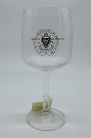
Glass - red wine, Shire of Bulla Australian Bicentennial red wine glass, 1988
This item was produced to commemorate the Australian Bicentennial 1788 - 1988An 'Anjou' style traditional red wine glass with a long stem and inturned bowl and flat base. There is a gold 'Shire of Bulla' transfer on the front.Front: 'Shire of Bulla' emblem Back: "Australian Bicentennial / 1788 - 1988"wine glasses, shire of bulla, australian bicentenary, festivals and celebrations, glasses, municipal offices, sunbury, george evans collection -
 Waverley RSL Sub Branch
Honour Rolls, Shire of Mulgrave Honour Roll
Set up by The Shire of Mulgrave. Later placed in front of the old RSL building at Glen Waverley. Now part of the Waverley RSL Memorabilia collection2 Marble Slabs erected by the Shire of Mulgrave to commemorate the men of the Shire who served in "The Great War"Shire of Mulgrave Honour Roll 1914 The Great War 1918 * Died in Service Plaque 1 ADAMS F., ADAMS A. , ADAMS. J, AJANI A. W. , AJANI E. ,ADJANI M., *ALCOCK J. ,ANDERSON G. McK. , ARMSTRONG S. ,ARNOLD W. R. ,ARNOTT W. –MM ,AURISCH F. R. , * BARKER F. ,BANKS D. A. ,BARKER E. J. H. ,BARKER L. C. S. ,BARKER R. C. I. , * BATTEN T. ,BEACON C. J. , BEACOM W. F. ,BEGS J. A. , BENNETT T. T. , BENNINGTON K. C. , BISCHOFFER K. S. E. ,BIZLEY L. ,BRAND A. M. , BRAND A. ,* BRAY R. L. , BRENNAN E. V. , BRENNAN W. J. , BREWER J. H. ,*BROWN S. , BRIDLE N. ,BUTCHER J. , BRABAZON F. , *CAMPBELL W. , CARLSON J. ,CHANDLER S. A. ,CLARKSON A. H. ,COCHRANE D. ,COLWELL E. ,*CORNELL C. ,CORNELL E. ,CORNELL R. ,COX B. T. ,CRAWLEY J. ,CRIPPS A. W. ,*CROW . , CUTTING R. ,DAYS E. J. ,DAGNALLA. E. , DALCOM T. ,DECARTE S. ,*DOOLAN W. E. ,*DOVER T. E. ,DUNTZELL R. ,DYER C. H. ,DYER H. ,DYKE H. ,EARLE A. F. , EVANS E. ,EVANS J. H. , FEAR H. ,*FEAR S. R. W. ,FIELDS C. J., *FURPHY A. F. ,GASCARD A. S. , GLENNON T. R. , GOBBI J. –MM ,GOULD T. D. , GRAY R. , GREENHAM A. ,GUNTHER C. J. ,GUNTHER H. V. , HENLEY A. , Plaque 2 HARRIS A. , HENLEY C. H. , HERRIOT S. T. ,*HERRIOT W. E. , HIND S. J. , HOLFORD J. S. S. , HORE H. R. ,*HORE S. C. , *HORNER C. S. C. ,HOURIGAN E. ,HOURIGAN F. ,HUNTER N. A. ,HURST W. K. , HUSSEY W. F. , JACKSON H. ,JAMES P. M. ,JANE R. W. –DCM, JOHNSON A. J. , *KELSALL W. J. ,KITCHEN J. H. ,KNIGHTS E. D. , LAITY J. E. ,LAITY F. C. , * LAW F. ,LAW J. ,LETCHE A. J. ,LECHTE D. W. ,MAILER D. ,MARKLE V. W. ,MARTIN W. E. ,MARWICK S. J. ,MAY J. ,MOORE A. J. ,MOYLAN P. , MUIR P. F. –MM , *MUNRO A. M. , MUNRO W. , MUNYARD W. ,MURPHY J. ,MUSTARD A. D. ,McGILL T. , McKELVIE F. W. ,McNALLY A. E. ,* McPHERSON A. P. ,OWENS H. C. ,OWENS O. , PARSONS G. ,PARSONS H. W. , PETERSON G. F. ,PEGG W. ,REEVE P. ,ROBBINS E. J. ,ROBBINS R. R. ,ROOKE W. L. ,SAWYER E. H. J. , SCAMMELL A. E. ,SHEPPARD H. ,SIM W. ,SIMMONS A. W. ,SMITH H. ,*SMITH N. , SMITH R. B. ,STEELE G. ,TURBER J. J. ,WATTS W. E. , WATTS W. E. ,* WHEELWRIGHT H. M. ,* WHITE D. C. ,WHITE S. G. S. ,WHITE W. ,WILLIAMS H. ,WILLIAMS L. ,WILLIAMS L. E. ,WILSON F. W. , WILSON H. R. ,WRIGHT W. ,WESTNEY P. E. –MM DCM , honour roll, great war, adams f., adams a., adams. j, ajani a. w., ajani e., adjani m., *alcock j., anderson g. mck., armstrong s., arnold w. r., arnott w. –mm, aurisch f. r., * barker f., banks d. a., barker e. j. h., barker l. c. s., barker r. c. i., * batten t., beacon c. j., beacom w. f., begs j. a., bennett t. t., bennington k. c., bischoffer k. s. e., bizley l., brand a. m., brand a., * bray r. l., brennan e. v., brennan w. j., brewer j. h., *brown s., bridle n., butcher j., brabazon f., *campbell w., carlson j., chandler s. a., clarkson a. h., cochrane d., colwell e., *cornell c., cornell e., cornell r., cox b. t., crawley j., cripps a. w., *crow ., cutting r., days e. j., dagnalla. e., dalcom t., decarte s., *doolan w. e., *dover t. e., duntzell r., dyer c. h., dyer h., dyke h., earle a. f., evans e., evans j. h., fear h., *fear s. r. w., fields c. j., *furphy a. f., gascard a. s., glennon t. r., gobbi j. –mm, gould t. d., gray r., greenham a., gunther c. j., gunther h. v., henley a., harris a., henley c. h., herriot s. t., *herriot w. e., hind s. j., holford j. s. s., hore h. r., *hore s. c., *horner c. s. c., hourigan e., hourigan f., hunter n. a., hurst w. k., hussey w. f., jackson h., james p. m., jane r. w. –dcm, johnson a. j., *kelsall w. j., kitchen j. h., knights e. d., laity j. e., laity f. c., * law f., law j., letche a. j., lechte d. w., mailer d., markle v. w., martin w. e., marwick s. j., may j., moore a. j., moylan p., muir p. f. –mm, *munro a. m., munro w., munyard w., murphy j., mustard a. d., mcgill t., mckelvie f. w., mcnally a. e., * mcpherson a. p., owens h. c., owens o., parsons g., parsons h. w., peterson g. f., pegg w., reeve p., robbins e. j., robbins r. r., rooke w. l., sawyer e. h. j., scammell a. e., sheppard h., sim w., simmons a. w., smith h., *smith n., smith r. b., steele g., turber j. j., watts w. e., * wheelwright h. m., * white d. c., white s. g. s., white w., williams h., williams l., williams l. e., wilson f. w., wilson h. r., wright w., westney p. e. –mm dcm, mulgrave -
 Eltham District Historical Society Inc
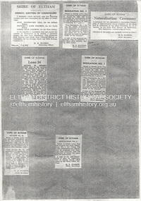
Document - Series Listing, Shire of Eltham, Series 74: Shire of Eltham - Newsclippings Folders; Vol. 1, Sept 1959 - Aug 1969
This Series consists of a set of three folders of historical newsclippings relating to the Shire. The first volume (Item I) spans Sept 1959 - Aug 1969 The second volume (Item 2) spans August 1969- Dec 1972 The third volume (Item 3) spans Jan 1971 - Dec 1973 Preservation copies have been made on archival paper. Reference copies have been made from the preservation copies. The reference copies have been placed in five ring binder folders: the first volume in Reference Folder I, the second volume in Reference Folder 2 and the third volume in Reference Folders 3 - 5.shire of eltham archives, newspaper clippings -
 Eltham District Historical Society Inc
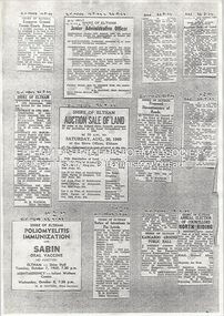
Document - Series Listing, Shire of Eltham, Series 74: Shire of Eltham - Newsclippings Folders; Vol. 2, Aug 1969 - Dec 1972
This Series consists of a set of three folders of historical newsclippings relating to the Shire. The first volume (Item I) spans Sept 1959 - Aug 1969 The second volume (Item 2) spans August 1969- Dec 1972 The third volume (Item 3) spans Jan 1971 - Dec 1973 Preservation copies have been made on archival paper. Reference copies have been made from the preservation copies. The reference copies have been placed in five ring binder folders: the first volume in Reference Folder I, the second volume in Reference Folder 2 and the third volume in Reference Folders 3 - 5.shire of eltham archives, newspaper clippings -
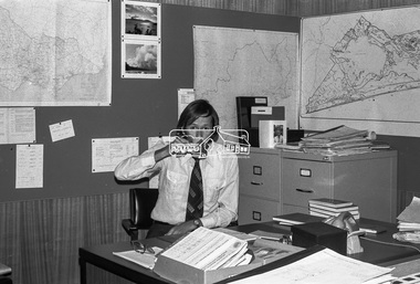
 Eltham District Historical Society Inc
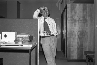
Negative - Photograph, Shire of Eltham, Eltham Shire Council Staff. Eltham Shire Office, 895 Main Road, Eltham, Jan. 1980
eltham, 895 main road, eltham shire council, eltham shire office, staff members -
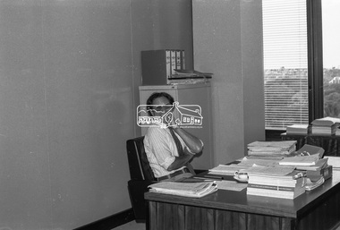
 Eltham District Historical Society Inc
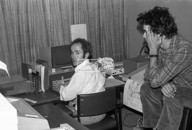
Negative - Photograph, Shire of Eltham, Eltham Shire Council Staff. Eltham Shire Office, 895 Main Road, Eltham, Jan. 1980
eltham, 895 main road, eltham shire council, eltham shire office, staff members -
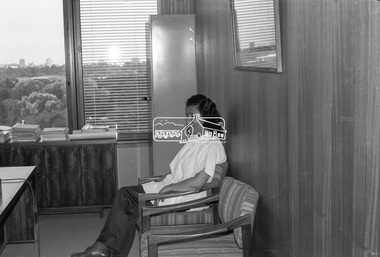
 Eltham District Historical Society Inc
Negative - Photograph, Shire of Eltham, Eltham Shire Council Staff. Eltham Shire Office, 895 Main Road, Eltham, Jan. 1980
eltham, 895 main road, eltham shire council, eltham shire office, staff members -
 Eltham District Historical Society Inc
Negative - Photograph, Shire of Eltham, Eltham Shire Council Staff. Eltham Shire Office, 895 Main Road, Eltham, Jan. 1980
eltham, 895 main road, eltham shire council, eltham shire office, staff members -
 Eltham District Historical Society Inc
Negative - Photograph, Shire of Eltham, Eltham Shire Council Staff. Eltham Shire Office, 895 Main Road, Eltham, Jan. 1980
eltham, 895 main road, eltham shire council, eltham shire office, staff members -
 Tatura Irrigation & Wartime Camps Museum
Entry Ticket, Shire Chambers Opening, 1968
In 1968 the very old council chambers and offices in Casey Street were replaced on the same site by new buildings. The card admitted its holder to the Official Opening.small card with string attached acted as entry ticket to function - official opening of new Shire Chambers in 1968. Blue still cardboard.Shire of Rodney Official Opening. Municipal office and council chambers. 12 December 1968. Entree card cocktail party. Shire Presidents Suite 4.30 pm. This card must be presented.shire of rodney -
 Eltham District Historical Society Inc
Audio - Audio Compact Cassette Tape, Shire of Eltham, Audio Recording; Listening to the landscape: stories and places collected from the Shire of Eltham, 1988, 1989
Listening to the landscape is a project in sound, made from recordings and interviews collected in and around the Shire of Eltham over the course of 12 months which were published in 1989. Thirty people, all of whom have lived or worked around the region most of their lives, were interviewed. There are six "channels" of stories: 1. Getting around - 2. "they were the wildflowers - we used to pick armfuls of them in those days" - 3."Up around Kinglake" - 4. "But it was home and no-one could put us out of it" - 5. "It was all orchards" - 6. "gradually the houses came". Each with a slightly different theme. The stories are supported by environmental and historical sound recordings. Tapes converted to three CDs - titled "Getting around" - Armful of flowers" and "Up around Kinglake" which includes the six "channels".Master recordings on three compact cassette audio tapes, TDK AD46. Each tape labeled with the recording track in red ink and Dolby B Noise Reduction activated) also in black ink copyright Duncan King-Smith 1989 Copy 1 Channel 2: Armfuls of Wildflowers Channel 4: “It was home . . .” Copy 2 Channel 1: Getting around Channel 6: “Gradually the houses came . . . ” Copy 3 Channel 3: Up around Kinglake Channel 5: “ . . it was all orchards.” Also commercial compact cassettes and CD formats held and information booklet. Converted to mp3 format from CD 1 - Getting Around; 17:17, 23.7 MB, 192kbs 2 - Gradually the houses came; 17:32, 24.0 MB, 192kbs 3 - Up around Kinglake; 23:31, 32.3 MB, 192kbs 4 - It was all orchards; 23:52, 32.7 MB, 192kbs 5 - Armful of wild flowers; 20:38, 28.3 MB, 192kbs 6 - But it was home, and no-one could put us out of it; 20:58, 28.8 MB, 192kbsaudio cassette, audio recording, duncan king-smith, eltham, listening to the landscape, compact disc, oral history, shire of eltham archives, series 45 -
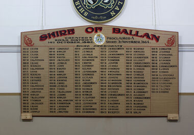 Ballan Shire Historical Society
Memorabilia, Ballan Shire President's Board
This Memorial Board lists all the Presidents of the old Ballan Shire and is a complete record from the creation of a Road District in 1862, then the creation of a Shire in 1864 through to when the Shire was amalgamated into the Moorabool Shire in 1994.A large memorial board listing all the Presidents of the Ballan Shire.See photographballan shire president's board., ballan local government