Showing 303 items matching "aqueduct"
-
 Greensborough Historical Society
Article - Journal - Excerpt, Victorian Government Gazette, Melbourne water supply 1890, 15/08/1890
An historical account from the Victorian Government Gazette 15/08/1890: Contract accepted - Melbourne Water Supply - Mephan Ferguson. Manufacture and erection of wrought iron tubular aqueduct over Plenty River near Greensborough. Addition and extension to Watts River Scheme.History of the Maroondah aqueduct1 p., photocopy of article, downloaded from State Library of Victoriamelbourne water, mmbw, maroondah aqueduct, plenty river, watts river -
 Kiewa Valley Historical Society
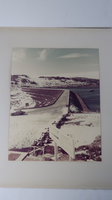
Photo - Rocky Valley Dam
The State Electricity Commission of Victoria constructed the Kiewa Hydro Electric Scheme on the Bogong High Plains. The scheme consisted of storage dams and pondages, aqueducts, tunnels, pipelines, transmission lines and three power stations.. Rocky Valley dam was the biggest storage and the last to be completed.Rocky Valley dam was the largest storage within the Kiewa Hydro Electric Scheme. Begun in 1954 and completed in 1960. It was linked to McKay Creek Power StationColoured photo attached to cream cardboard. The background shows hills and the foreground a sign "Rocky Valley Dam ..." The middle shows the dam with water and its bank. There is snow on the ground.rocky valley dam, kiewa hydro electric scheme, secv -
 Eltham District Historical Society Inc
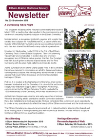
Newsletter, Newsletter, No. 224 September 2015
Contents: • A Currawong Takes Flight • September Meeting - Nillumbik Tales: Voices of our Elders • September Excursion - Research Aqueduct Walk • The Wackett Brothers by Jim Allen • Picnic at Wattle Glen by Richard Pinn • Murray's Land • ....and also • Contacts for the Eltham District Historical Society The Shire of Eltham Historical Society was formed in October 1967. The first newsletter of the Society was issued May 1978 and has been published continuously ever since on a bi-monthly basis. With the cessation of the Shire of Eltham in late 1994, the Society's name was revised to Eltham District Historical Society and this name first appeared with issue No. 103, July 1995. The collection of the Society's newsletters provides a valuable resource on the history of the Society's activities, office bearers and committee members, guest speakers and subjects of historical interest pertinent to the former Shire of Eltham and the Eltham District.A4 photocopied newsletter distributed to membersnewsletter, eltham district historical society, shire of eltham historical society -
 Flagstaff Hill Maritime Museum and Village
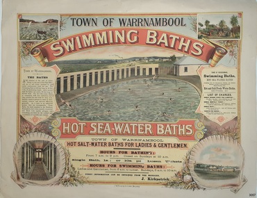
Poster - Recreation, Town of Warrnambool Swimming Baths, ca. May 1884
The poster advertises these Swimming Baths as “the most complete in the Southern Hemisphere”. In February 1877 a Baths Company (1050 shares) was formed in the town of Warrnambool for the establishment of the baths at the south end of Gillies Street. The baths were filled with sea water from Lady Bay, originally pumped by a windmill situated near the current Surf Lifesaving Club and carried by iron pipes to the Public Baths; later the water was pumped by a gas motor. Hot and cold fresh water baths were advertised. The gentlemen’s bath was 100 feet long and 50 feet wide, of graduating depth. A second bath, solely for ladies, was 60 feet long by 30 feet wide. Hot Sea water Baths were also part of the institution, and were sought after for their ‘wonderful curative powers’, and ‘incomparable’ as a ‘tonic for the feeble’. In June 1881 the Hot Sea Baths were opened, and both hot and cold water baths were supplied at reasonable charges. Patrons came from near and far to receive the benefits. The manager of the Baths was J. Kirkpatrick. The Baths Company struggled for several years without success, so in 1883 the baths were sold to the Borough Council for 1250 pounds. The original shareholders received nothing for their outlay; the overdraught was over the sale price. In May 1884 the Council announced that an estimated they has spent 1000 pounds in improving the baths since purchasing them and were now returning an income of 11 per cent. Historically significant to Warrnambool and the recreational facilities available in the 1880s to 1900s. The remains of the baths are still visible to the public today.Poster on heavy cream paper, landscape orientation, with coloured print. The poster advertises the Warrnambool Swimming Baths. It has several drawings such as Middle Island and the Merri River Mouth with vessels in the water, The inside of the Baths facility, the men's baths with the adjacent bathing rooms and figures in and out of the water, a cottage with figures in the garden, and fenced buildings with a windmill and aqueduct or pipes. The text describes the location and advantages, the opening times and various costs. It was printed in Ballarat by F.W. Niven & Co. Lithos."TOWN OF WARRNAMBOOL" "SWIMMING BATHS" "HOT SALT-WATER BATHS FOR LADIES AND GENTLEMEN" "HOURS FOR BATHING fROM 7 a.m. to 9 p. m. Closed on Sundays at 10 a.m." Single Bath 1s [1 shilling]; or 10s per Dozen Tickets" "HOURS FOR SWIMMING BATHS: Ladies and Gentlemen, from 6 a.m. to Sunset, Sundays 6 a.m. to 10 a.m." "Every information can be obtained from the Manager, J. Kirkpatrick" "HOT SEA-WATER BATHS ... strongly recommended by the Medical Faculty" "Hot and Cold Fresh Water Baths" "Showers etc." "LIST OF CHARGES ... Single Season Ticket, Single Monthly Ticket, Single Bath without towel ... with towel.. Tickets per dozen without towel, with towel..." "The Baths are situated at the end of Gillies Street, in the rear of the Post Office, and are of salt water pumped by gas motor continuously from the sea. The Swimming Bath is 100 feet long by 50 feet wide, of graduating depth; and a second bath for ladies' use solely, 60 feet long by 30 feet wide. The hot Sea-water Baths in connection with this institution have been extolled far and wide for their wonderfully curative powers in cases of rheumatism, sciatica, and nervous afflictions generally. As a tonic to an enfeebled system, they are incomparable, These Baths, the most complete in the Southern Hemisphere, have been recently re-erected and fitted with marble plunges, and everything provided for the comfort and convenience of invalids and visitors." "F.W. NIVEN & Co, LITHOS, BALLARAT"flagstaff hill, warrnambool, warrnambool swimming baths, hot sea water baths warrnambool, warrnambool baths company, f.w. niven & co, warrnambool therapudic baths, town of warrnambool, swimming baths, hot sea water baths, salt water baths, ladies' baths, gentlemen's baths, warrnambool town baths, j kirkpatrick -
 Eltham District Historical Society Inc
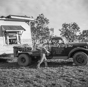
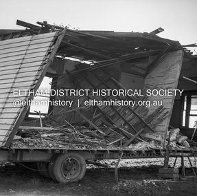
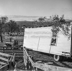
Negative - Photograph, J.A. McDonald, Removal of the remains of the Abraham house at Kangaroo Ground, c. May 1962
Martin Bros House Removing of Seaford was contracted to remove the remains of the storm damaged Abraham house from the property circa May 1962. The Abraham family owned land near the Aqueduct and east of Nicholas Lane at Kangaroo Ground (based on photos, at or near 40 Nicholas Lane).Record of various Shire of Eltham infrastructure works undertaken during the period of 1952-1962 involving bridge and road reconstruction projects, sometimes with Eltham Shire Council Project Reference numbers quoted. It was during this period that a number of significant improvements were made to roads and new bridges constructed within the shire that remain in place as of present day (2022). In many situations, the photos provide a tangible visible record of infrastructure that existed throughout the early days of the Shire. The album was put together by or under the direction of the Shire Engineer, J.A. McDonald.1962-05, abraham house, kangaroo ground, martin bros house removing seaford, nicholas lane, property damage -
 Eltham District Historical Society Inc
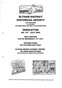
Newsletter, Newsletter, No. 157 July 2004
Contents: • Next meeting, Speaker Panel: On the Heritage Trail • Eltham Major Activity Centre • Maroondah Aqueduct Across the Plenty River • Eltham East Choir • President’s Notes • Alan Marshall’s Bungalow • Robert Bruce Ness 1917-2004 incl Ness Family History by Joy Ness • More News The Shire of Eltham Historical Society was formed in October 1967. The first newsletter of the Society was issued May 1978 and has been published continuously ever since on a bi-monthly basis. With the cessation of the Shire of Eltham in late 1994, the Society's name was revised to Eltham District Historical Society and this name first appeared with issue No. 103, July 1995. The collection of the Society's newsletters provides a valuable resource on the history of the Society's activities, office bearers and committee members, guest speakers and subjects of historical interest pertinent to the former Shire of Eltham and the Eltham District.A4 photocopied newsletter distributed to membersnewsletter, eltham district historical society, shire of eltham historical society -
 Greensborough Historical Society
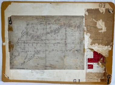
Poster - Planning Document, Shire of Diamond Valley, Subdivision Plan # G 1, Watsonia, 1962 and 1976
Plan of Subdivisions in Shire of Diamond Valley: Side 1: subdivision of LP5406 bounded by Plenty Road, Greensborough Road, Meakin Avenue, Watsonia and includes Aqueduct Road, 1976. Side 2: 2 plans - Keelbundoora: Morwell Avenue and Grace Street; Nillumbik: Inglis Street and Chute Street Diamond Creek, 1962An example of hard copy subdivision plans from the Greensborough area. Mainly from the Shire of Diamond Valley era (1964-1994).Plan (2 sided) mounted on heavy card. Contains 2 sheets pasted together.Stamped and handwritten Council permissions, dates and other details. subdivision plans, diamond creek, shire of diamond valley -
 Clunes Museum
Document - ARCHITECTURAL DRAWINGS, CLUNES WATER SUPPLY
CLUNES WATER SUPPLY .1 DRAWING No 21 (CHANGED TO 11). LOWER WEIR. DETAILS OF MASONRY - DESIGN B .2 DRAWING No 5 CONTRACT No 2. LONGITUDINAL SECTION OF CENTRE LINE OF LOWER AQUEDUCT FROM WEIR A TO SERVICE RESERVOIR .3 DESIGNS FOR WEIRS - CROSS SECTION OF THE BED OF THE CREEK SHOWING WEIR STRUCTURE. .4 DRAWING No 11. LONGITUDINAL SECTION - PROPOSED LINE OF PIPES No 1 RESERVOIR. .5 DRAWING No 17 SECTIONS. HANDWRITTEN. .6 DRAWING No 5. PLAN OF LINE OF PIPES No 1 RESERVOIR..2 HANDWRITTEN NOTES ON REAR IN PENCILclunes, water supply, drawings -
 Greensborough Historical Society
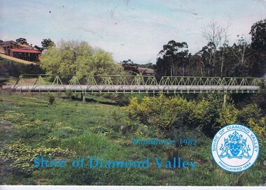
Booklet, The Shire of Diamond Valley Handbook 1982, 1982_
Guide to services provided by Shire of Diamond Valley. The Shire of Diamond Valley was a Local Government Area located about 20 kilometres northeast of Melbourne. The shire covered an area of 74.38 square kilometres and existed from 1964 until 1994. Cover illustration of aqueduct and bridge over Plenty River near Apollo Parkways estste.Annual guide to services in Shire of Diamond Valley32 pages, col illus., maps. 2 copiesshire of diamond valley, greensborough, handbooks -
![Newspaper clipping [copy], Greensborough farm 8500 [pounds], 23/12/1947](/media/collectors/4f729f5697f83e03086015b8/items/5d1d78dc21ea6a1138d1fd4a/item-media/5d1dcff421ea6b11381717d8/item-fit-380x285.jpg) Greensborough Historical Society
Greensborough Historical SocietyNewspaper clipping [copy], Greensborough farm 8500 [pounds], 23/12/1947
Corrabert Park was owned by Francis Flintoff, sold c. 1924 to Mr. E. Fullwood, who sold the property in December 1947 to Mr. W. M. Bamford for 8500 pounds. The land had frontage to the Plenty River and water from the MMBW aqueduct which passed through the property. There was a residence and two small rented cottages on the property. The area is currently known as Apollo Parkways.Copy of news clipping.Corrabert Park sold - newspapers.comcorrabert park, apollo parkways -
 Federation University Historical Collection
Book, Railway Practice: a collection of working plans and practical details of construction in the public works of the most celebrated engineers, 1847 (exact)
A green cloth hard cover book. Title and author's name are engraved in gold on spine. This is the 3rd edition, first series with black and white illustrations. It describes the engineering practices of the early days of British railroads. The book includes (series 1 to 4)and it contains, roads, tramroads and railroads, bridges, aqueducts, viaducts, wharfs, warehouses, roofs, and sheds, canals, locks, sluices, & the various works on rivers, streams, etc., harbours, docks, piers and jetties, tunnels, cuttings and embankments, the several works connected with the drainage of marshes, marine sands, and the irrigation of land, water-works, gas-works, water-wheels, mills, engines.civil engineering, railway practice, rail constructions, s c brees, western railway great britain, public works, railroads, canals, s.c. brees, samuel brees, samuel charles brees -
 Greensborough Historical Society
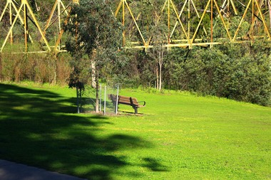
Photograph - Digital Image, Marilyn Smith, The Separation Tree Greensborough 2019, 02/07/2019
The original Separation Tree was one of two red river gums that pre-dated European occupation, and was the site where colonists congregated to celebrate the announcement of Victoria's separation from New South Wales on 15 November 1850. It died as the result of vandalism in 2010 and 2013. Saplings of the original were planted around Melbourne in 2014, including this one along the Plenty River Trail in Greensborough. The old aqueduct bridge can be seen in background.2 colour digital photographsseparation tree, plenty river trail, aqueduct pipe bridge greensborough -
 Flagstaff Hill Maritime Museum and Village
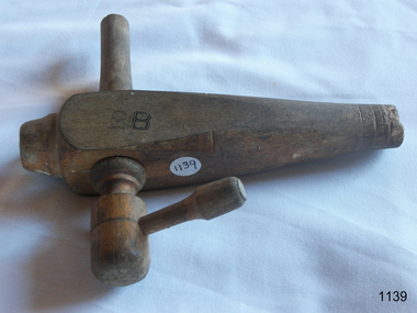
Functional object - Barrel Spigot, H Gage, Early 20th century
Ancient Greek and Roman first used spigots in their bathhouses for obtaining water from aqueducts, routing it into pipes and buildings, and finally into their tubs or baths. The subject spigot or tap in Flagstaff collection was used in wine, beer, or spirits barrels to dispense the liquid contained within. A spigot definition is a device that controls the flow of liquid from a container. As mentioned earlier the Greeks and Romans created theirs for use in plumbing water later spigots were adapted to use in barrels or casks. An item still in use today in wine and beer barrels to dispense liquid and although spigots today are made from differing materials other than wood their function has not changed over the centuries.Wooden barrel spigotMarked "H Gage Maker Melbourne" on the side & 2B marked in black flagstaff hill, warrnambool, flagstaff-hill-maritime-museum, maritime-museum, shipwreck-coast, flagstaff-hill-maritime-village, barrel spigot, cask tap, h gage melbourne, coopering accessories -
 Eltham District Historical Society Inc
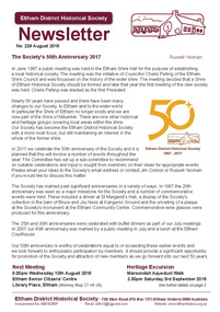
Newsletter, Newsletter, No. 229 August 2016
Contents: • The Society's 50th Anniversary 2017 by Russell Yeoman • Our Next Meeting - Wednesday 10th August; 'Creators, Makers and Shakers' • Heritage Excursion - Maroondah Aqueduct Walk - Saturday 3rd September • Eltham District's Early History • The Eltham Barrel by Jim Allen • Eltham Taps Run Dry • A Footnote on Shoestring • Membership Subscriptions • The Little Church in St Helena by Maureen Smith • St Katherine's Church in St Helena • Beauty Spots • ... and also • Contacts for the Eltham District Historical Society The Shire of Eltham Historical Society was formed in October 1967. The first newsletter of the Society was issued May 1978 and has been published continuously ever since on a bi-monthly basis. With the cessation of the Shire of Eltham in late 1994, the Society's name was revised to Eltham District Historical Society and this name first appeared with issue No. 103, July 1995. The collection of the Society's newsletters provides a valuable resource on the history of the Society's activities, office bearers and committee members, guest speakers and subjects of historical interest pertinent to the former Shire of Eltham and the Eltham District.A4 photocopied newsletter distributed to membersnewsletter, eltham district historical society, shire of eltham historical society -
 Eltham District Historical Society Inc
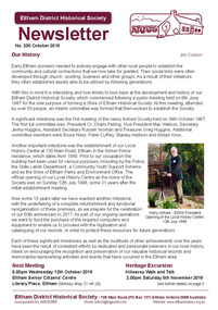
Newsletter, Newsletter, No. 230 October 2016
Contents: • Our History by Jim Connor • Our Next Meeting - Wednesday 12th October • Heritage Excursion - Kileavey Walk and Talk - Saturday 5th November • The Festive Reason by Mal Harrop • History of Maroondah Aqueduct Pipe Bridge over the Plenty River at Greensborough by Anne Paul • One Hundred Years Ago: Eltham and District - July-December 1916 by Liz Pidgeon • From the Hurstbridge Advertiser 2 March 1923 • Refurbishment of our Local History Centre • ... and also • Contacts for the Eltham District Historical Society The Shire of Eltham Historical Society was formed in October 1967. The first newsletter of the Society was issued May 1978 and has been published continuously ever since on a bi-monthly basis. With the cessation of the Shire of Eltham in late 1994, the Society's name was revised to Eltham District Historical Society and this name first appeared with issue No. 103, July 1995. The collection of the Society's newsletters provides a valuable resource on the history of the Society's activities, office bearers and committee members, guest speakers and subjects of historical interest pertinent to the former Shire of Eltham and the Eltham District.A4 photocopied newsletter distributed to membersnewsletter, eltham district historical society, shire of eltham historical society -
 Kiewa Valley Historical Society
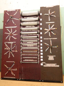
S.E.C.V. Transmission Cables Board, c1940's
Differing gauges of transmission line was/is used in the Kiewa Hydro Electric Scheme. Some carried 330KV, 220KV, 66KV (Mount Beauty to Bright) and (Clover to Mount Beauty) and 22KV. All the cables have a core of steel for strength and an aluminium outer layer for transmission. Examples include 66KV copper cable, copper earth wire from the towers, copper cable found along the aqueducts for telemetering and copper earth wire. The 24 Volt Communication cables were/are used for linking different sites on remote SEC equipment.The State Electricity Commission of Victoria constructed the Kiewa Hydro Electric Scheme during the late 1930's to 1960's. A wooden board with samples of differing gauges of transmission cables used for the transmission of power and 24 volt communication cables used for communication linking different sites on remote S.E.C. equipment. The cables No.s 1 to 9 have a core of steel for strength and an aluminium outer layer for transmission. The copper cables No.s 10 - 14 are used for earthing and are in the ground as copper doesn't rust or corrode (steel does). Copper is three times heavier (dense) than aluminium. Each of the outside aluminium wires are wound in the opposite direction so that when the cable is stretched under load, they tighten.state electricity commission of victoria. kiewa hydro electric scheme. cable. communication. transmission. telemetering. power. electricity. -
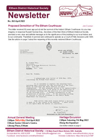 Eltham District Historical Society Inc
Journal - Newsletter, Newsletter, No. 263 April 2022, Apr 2022
Contents: • Proposed Demolition of the Eltham Courthouse by Jim Connor • Heritage Excursion – Along the Aqueduct – Saturday 7th May 2022 • Municipal District – Eltham (Victoria Gazette No. 140 – March 26, 1957 • Eltham Courthouse Officially Reopened by Jim Connor • Murray’s Bridge by Jim Connor • Shire of Eltham • A 21st Celebration? By Jim Connor • Eltham Cemetery Stories by Liz Pidgeon o Elizabeth Agatha (Betty) Erickson, nee Carrucan 1915-1990 • Our History – Our Library • Annual General Meeting – 2.00pm, Saturday 23rd April 2022The Shire of Eltham Historical Society was formed in October 1967. The first newsletter of the Society was issued May 1978 and has been published continuously ever since on a bi-monthly basis. With the cessation of the Shire of Eltham in late 1994, the Society's name was revised to Eltham District Historical Society and this name first appeared with issue No. 103, July 1995. The collection of the Society's newsletters provides a valuable resource on the history of the Society's activities, office bearers and committee members, guest speakers and subjects of historical interest pertinent to the former Shire of Eltham and the Eltham District.A4 newsletter distributed to members (Digital and A4 photocopy)newsletter, eltham district historical society -
 Eltham District Historical Society Inc
Photograph - Aerial Photograph, Landata, Research, Vic, Apr. 1963
Centred on present day Marconi Court, Research bounded by Maroondah Aqueduct to north, Thompson Crescent to south, Joselyn Drive to east and Eltham Research Oval to west. Historic Aerial Imagery Source: Landata.vic.gov.au Aerial Photo Details: Project No :486 Project : MELBOURNE (1963) PROJECT Run : 5 Frame : 62 Date : 04/1963 Film Type : B/W Camera : RC8 Flying Height : 5100 Scale : 9600 Film Number : 1805 GDA2020 : 37°42'24"S, 145°10'43"E MGA2020 : 339434, 5825157 (55) Melways : 22 F3 (ed. 42)aerial photo, neil webster collection, 1963-04, joselyn drive, marconi court, melway 22f3, research (vic.), research oval, thompson crescent -
 Eltham District Historical Society Inc
Photograph - Aerial Photograph, Landata, Eltham / Research, Vic, Jan. 1951
Centred on Brinkkotter Road opposite Yarramie Reserve, Eltham bounded by Maroondah Aqueduct to north, Nyora Road to south, Eltham College to east and Leane Drive to west. Historic Aerial Imagery Source: Landata.vic.gov.au Aerial Photo Details: Project No :65 Project : MELBOURNE AND METROPOLITAN PROJECT NO. 2 Run : 7 Frame : 8 Date : 01/1951 Film Type : B/W Camera : EAG9 Flying Height : 12200 Scale : 12000 Film Number : 1419 GDA2020 : 37°42'32"S, 145°10'41"E MGA2020 : 339408, 5824924 (55) Melways : 22 F3 (ed. 42)Historical aerial photos and photo maps provide viusal evidence of the chronology of changes to the built landscape of the district and assist in dating other imagesaerial photo, 1951-01, eltham, neil webster collection, brinkkotter road, eltham college, leane drive, maroondah aqueduct, melways 22f3, nyora road, yarramie reserve -
 Eltham District Historical Society Inc
Photograph - Aerial Photograph, Landata, Eltham, Vic, Jan. 1951
Centred on Beard Street between Main Road and Frank Street, Eltham bounded by Maroondah Aqueduct to north, Arthur Street to south, Maroong Drive to east and Catholic Ladies College to west. Historic Aerial Imagery Source: Landata.vic.gov.au Aerial Photo Details: Project No :65 Project : MELBOURNE AND METROPOLITAN PROJECT NO. 2 Run : 7 Frame : 9 Date : 01/1951 Film Type : B/W Camera : EAG9 Flying Height : 12200 Scale : 12000 Film Number : 1419 GDA2020 : 37°42'23"S, 145°09'39"E MGA2020 : 337874, 5825170 (55) Melways : 22 B3 (ed. 42)Historical aerial photos and photo maps provide viusal evidence of the chronology of changes to the built landscape of the district and assist in dating other imagesaerial photo, 1951-01, eltham, neil webster collection, arthur street, beard street, catholic ladies college, frank street, main road, maroondah aqueduct, maroong drive, melway 22b3, research (vic.) -
 Eltham District Historical Society Inc
Photograph - Aerial Photograph, Landata, Research, Vic, Feb. 1956
Centred on present day Thompson Crescent, Research bounded by Maroondah Aqueduct to north, Thompson Crescent and Nyora Road to south, Bells Hill Road to east and Eucalyptus Road to west Historic Aerial Imagery Source: Landata.vic.gov.au Aerial Photo Details: Project No :250 Project : MELBOURNE OUTER SUBURBS PROJECT Run : 19 Frame : 6 Date : 02/1956 Film Type : B/W Camera : EAG9 Flying Height : 10000 Scale : 12000 Film Number : 1176 GDA2020 : 37°42'38"S, 145°11'02"E MGA2020 : 339927, 5824736 (55) Melways : 22 H4 (ed. 42)aerial photo, 1956-02, neil webster collection, bells hill road, eltham, eucalyptus road, maroondah aqueduct, melway 22h4, nyora road, research (vic.), thompson crescent -
 Eltham District Historical Society Inc
Photograph - Aerial Photograph, Landata, Research, Vic, Apr. 1963
Centred on present day Thompson Crescent and Nicholson Close, Research bounded by Maroondah Aqueduct to north, Nyora Road to south, Eltham College to east and Eltham Gateway Hotel to west. Historic Aerial Imagery Source: Landata.vic.gov.au Aerial Photo Details: Project No :486 Project : MELBOURNE (1963) PROJECT Run : 5 Frame : 61 Date : 04/1963 Film Type : B/W Camera : RC8 Flying Height : 5100 Scale : 9600 Film Number : 1805 GDA2020 : 37°42'24"S, 145°10'06"E MGA2020 : 338528, 5825143 (55) Melways : 22 D3 (ed. 42)aerial photo, neil webster collection, eltham, 1963-04, eltham college, eltham gateway hotel and conference centre, maroondah aqueduct, melway 22d3, nicholson close, nyora road, research (vic.), thompson crescent -
 Eltham District Historical Society Inc
Photograph - Aerial Photograph, Landata, Eltham, Vic, Feb. 1956
Centred on present day Parsons Avenue at Leane Drive near the Maroondah Aqueduct, Eltham bounded by Lorimer Road to north, Thompson Crescent and Norman Road to south, Bells Hill Road to east and Parsons Road to west Historic Aerial Imagery Source: Landata.vic.gov.au Aerial Photo Details: Project No :250 Project : MELBOURNE OUTER SUBURBS PROJECT Run : 19 Frame : 5 Date : 02/1956 Film Type : B/W Camera : EAG9 Flying Height : 10000 Scale : 12000 Film Number : 1176 GDA2020 : 37°42'04"S, 145°11'09"E MGA2020 : 340064, 5825786 (55) Melways : 22 H1 (ed. 42)aerial photo, 1956-02, neil webster collection, allendale road, bells hill road, eltham, leane drive, lorimer road, maroondah aqueduct, melway 22h1, norman road, parsons road, research (vic.), thompson crescent -
 Eltham District Historical Society Inc
Photograph - Aerial Photograph, Landata, Eltham, Vic, Apr. 1963
Centred on present day Zig Zag Road and Main Road, Eltham bounded by Maroondah Aqueduct to north, Thompson Crescent and Arthur Street to south, Parsons Road to east and Glen Park Road and Banks Road to west. Historic Aerial Imagery Source: Landata.vic.gov.au Aerial Photo Details: Project No :486 Project : MELBOURNE (1963) PROJECT Run : 5 Frame : 59 Date : 04/1963 Film Type : B/W Camera : RC8 Flying Height : 5100 Scale : 9600 Film Number : 1805 GDA2020 : 37°42'24"S, 145°08'52"E MGA2020 : 336716, 5825114 (55) Melways : 21 J3 (ed. 42)aerial photo, neil webster collection, eltham, 1963-04, arthur street, banks road, glen park road, maroondah aqueduct, melway 21j3, parsons road -
 Eltham District Historical Society Inc
Photograph - Aerial Photograph, Landata, Eltham, Vic, Apr. 1963
Centred on present day Floriston Grove, Eltham bounded by Maroondah Aqueduct to north, Thompson Crescent and Diosma Road to south, Research Shops to east and Glen Park Road and Park West Road to west. Historic Aerial Imagery Source: Landata.vic.gov.au Aerial Photo Details: Project No :486 Project : MELBOURNE (1963) PROJECT Run : 5 Frame : 60 Date : 04/1963 Film Type : B/W Camera : RC8 Flying Height : 5100 Scale : 9600 Film Number : 1805 GDA2020 : 37°42'24"S, 145°09'29"E MGA2020 : 337622, 5825128 (55) Melways : 22 B3 (ed. 42)aerial photo, neil webster collection, eltham, 1963-04, diosma road, floriston grove, maroondah aqueduct, melway 22b3, park west road, research (vic.), research shops -
 Eltham District Historical Society Inc
Photograph - Aerial Photograph, Landata, Research, Vic, Apr. 1972
Centred on present day Main Road, Research near Maroondah Aqueduct and Eltham College bounded by Allendale Road to north, Research-Warrandyte Road to south, Swipers Gully Training Restaurant to east and Reynolds Road to west. Historic Aerial Imagery Source: Landata.vic.gov.au Aerial Photo Details: Project No :985 Project : MELBOURNE 1972 Run : 26 Frame : 194 Date : 04/1972 Film Type : B/W Camera : RC10 Flying Height : 5700 Scale : 9600 Film Number : 2636 GDA2020 : 37°42'07"S, 145°11'07"E MGA2020 : 340015, 5825692 (55) Melways : 22 H1 (ed. 42)aerial photo, neil webster collection, 1972-04, allendale road, eltham college, main road, maroondah aqueduct, melway 22h1, research (vic.), research-warrandyte road, reynolds road, swiper's gully