Showing 14224 items
matching bridge-playing
-
 Eltham District Historical Society Inc
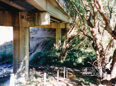
Photograph, Doug Orford, Bridge Street Bridge, Eltham
Two colour photographs of Bridge Street Bridge over Diamond Creek, Eltham showing bridge sub-structurebridges, diamond creek, eltham, bridge street -
 Eltham District Historical Society Inc
Photograph, Doug Orford, Bridge Street Bridge, Eltham
Two colour photographs of Bridge Street Bridge over Diamond Creek, Eltham showing bridge sub-structurebridges, diamond creek, eltham, bridge street -
 Nillumbik Shire Council
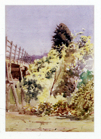
Painting: Walter WITHERS (b.1854 Warwickshire, UK — d.1914 Eltham, Aus), Trestle Bridge, Eltham, c.1903-10
Walter Withers was a significant Australian landscape artist and a member of the Heidelberg School of Australian Impressionists. In 1903 Withers bought 'Southernwood', a house on 2½ acres (1 ha) at Eltham, to which he added a studio. Because of ill health, he lived during the week at his studio in Oxford Chambers, Melbourne, and on weekends and holidays with his family at Eltham until his death in 1914. The Eltham rail bridge is a unique and valuable historic relic of an earlier steam locomotive transport era in the Diamond Creek Valley and has long formed an important part of a magnificent Eltham landscape. When built in 1902 it was close to the terminus point of the Heidelberg-Eltham rail extension, on the route of the proposed Diamond Valley Railway that was then planned to continue much further up the valley towards Kinglake. This bridge is situated in attractive river-valley parkland amidst the tall and spreading manna gums and candlebarks of the Diamond Creek Valley. The Alistair Knox Park river-valley landscape, of which the timber trestle bridge is an important visual component, has been classified by the National Trust. Large manna gum and candlebark trees adorn the adjacent creek banks, and historic Shillinglaw Cottage is also part of this much-prized Eltham landscape. Eltham is home to a historic wooden railway trestle bridge. Mainly of timber-pier and timber-beam construction, but varied by a few longer steel-joists spans on timber piers at the main stream channel, this substantial bridge has almost two hundred metres of timber deck. Built in 1902, it is the only railway bridge of predominantly timber construction that is still in regular use as an integral part of Melbourne's metropolitan electric railway network and one of extremely few timber rail bridges in the State that still carry trains. Apart from its important continuing social function as a carrier of rail transport for the Hurstbridge line, this impressive bridge and its beautiful parkland environs contribute much to the character of Eltham township and that town's special reputation as an historic centre of environmental and conservation concerns. This section of the Diamond Creek Valley was the subject of a Walter Withers painting in the earliest years of the twentieth century and has strong historic links with our Heidelberg School of painters. Watercolour painting on paper of Eltham's Trestle Bridge in the middle of the day. A small section of the wooden bridge is located to the left of the painting. The focus is predominately on the wattle, manna gum and candlebark trees that is to the right of the bridge. The golden hues typically represent the australian sunlight and landscape. "W.W" in gothic script on the lower right side of the painting. Not dated. withers, eltham, trestle bridge, railway, watercolour -
 Clunes Museum
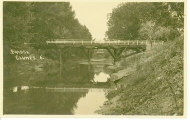
Photograph, D.S.KING. MOORE ST. EAST ARARAT
BRIDGE OVER CRESWICK CREEKBRIDGE OVER CREEK "BUTTER FACTORY" BRIDGE AT THE FOOT OF CAMERON ST. CLUNES.BRIDGE. CLUNES 6local history, document, postcard, bridges -
 City of Whittlesea
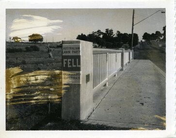
Photograph - Photographs - Bridges, Photograph - Bridge - Bundoora, 1967
Bridge over Darebin Creek, Settlement Road Bundoora. Looking west towards Thomastown, April 1967. Bridge post includes Australian Labor Party election poster for Greensborough Electorate. Bob Fell was the ALP candidate at the 1967 state election which he lost.Photographs, black and white print on paper. Bridge over Darebin Creek, Settlement Road Bundoora 1967. -
 Greensborough Historical Society
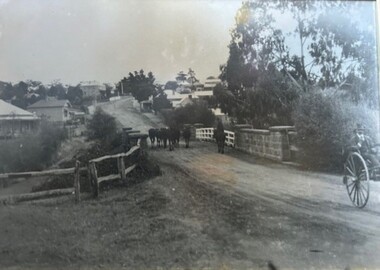
Photograph - Photograph (Framed), Herding stock over blue stone bridge looking up Main Street Greensborough
Heading stock over Blue stone bridge looking up Main Street Greensborough. In this photograph, Greensborough was a country town. Note the unmade road leading up to the bridge.From the John Mackey collection. This item was displayed at the offices of Ryan, Mackey and Kelly, solicitors, Main Street Greensborough.Timber-framed photograph of herding stock over blue stone bridge looking up Main Street Greensborough, black and white.greensborough, john mackey, blue stone bridge, marble hall -
 Melbourne Tram Museum
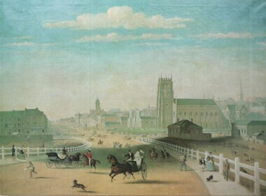
Artwork, other - Swanston Street from Princes Bridge c1861
Colour print of Reproduction of an oil painting - Swanston Street from Princes Bridge c1861 showing Johnson's Bridge Hotel, later Young and Jacksons, the first St Paul's church building, original Town Hall building and the tower of Scots church. Shows pedestrians and horse drawn carriages before the introduction of public omnibus services in 1869. Not known who produced the card.Yields information about early Melbourne after the start of the gold rush.Reproduction of an oil painting - Swanston Street from Princes Bridge c1861 by Henry BurnIn ink on the rear Keith Kings stamp and the initials RG and "Melbourne"melbourne, princes bridge, horse drawn vehicles, st pauls cathedral, hotels -
 Bialik College
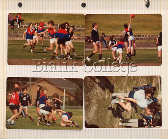
Photorgraphs, Students playing football, c. 1980-1982, c. 1980-1982
... Students playing football, c. 1980-1982 ...Students playing football, c. 1980-1982. Please contact [email protected] to request access to this record.1980s, sport -
 Bialik College
Photograph, ELC students playing with shells, c. 2000s, c. 2000s
... ELC students playing with shells, c. 2000s ...ELC students playing with shells, c. 2000s. Please contact [email protected] to request access to this record.early learning centre, 2000s, classroom, play -
 Buninyong Visitor Information Centre
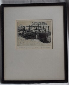
Print - Engraving, The Old Bridge, Buninyong No. 24
The location of the bridge has not yet been identified but further investigations will continue, as will details of when the work was completed by Graham Hopwood.A significant images of an early local structure in Buninyong. Requires further research.Engraving of a rough old timber bridge in Buninyong by artist and art educator, Graham Hopwood.Hand written on the backing paper of the frame: 'Originally owned by JM Matheson, given to Marjorie Matheson, 1956, Olympic Games'.graham hopwood, bridges, engravings, topographical art, buninyong -
 Phillip Island and District Historical Society Inc.
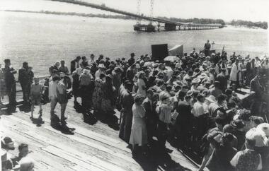
Photograph, Suspension Bridge, 1940
Official opening of Suspension Bridge 1940. Opened by Hon. Albert Dunstan LMHCrowd on work platform. View of new Suspension Bridge at Official Opening. Priest at Lectern at middle right. local history, photographs, civil engineering, bridges, official bridge opening, black & white photograph, jack jenner collection, phillip island bridges, public construction -
 Glenelg Shire Council Cultural Collection
Document - Engineering report - typed, 10/02/1964
Five foolscap pages with typed information and photographs, Dartmoor Hamilton Road, Bridge over Humphy's Creek. Stapled top left, signed by E.J.E. Byrne, Bridge Inspecting Engineer.engineering, professional report, bridge, building works, dartmoor -
 Phillip Island and District Historical Society Inc.
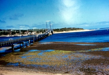
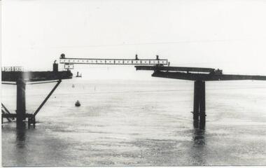
Photograph, First Phillip Island Bridge, Pre 1968
Original Phillip Island bridge which was replaced in 1968Large coloured photo of the first Phillip Island Bridge looking from Newhaven towards San Remo at low tide.Nilnewhaven, phillip island bridge, san remo -
 Eltham District Historical Society Inc
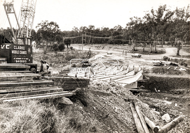
Photograph, Construction of new bridge over the Plenty River, Main Road, Lower Plenty, c.Aug. 1966
Construction of the Main Road bridge over the Plenty River. Includes structural members, construction personnel, vehicles and a Clarke mobile crane.Local significanceBlack and white printMarking on back of photograph - Plenty River Bridge Main Road 1969 (sic)lower plenty, main road, plenty river, bridge, bridge construction, civil engineering, cranes, mobile cranes -
 Mt Dandenong & District Historical Society Inc.
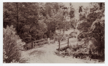
Photograph, The Crescent Bridge, Sassafras
Photograph taken at the bottom of the hill on 'The Crescent' at Sassafras where the Crescent Bridge crosses the Sassafras Creek.Black and white cop of a photograph showing a bridge crossing an unmade road over creek. Bush in background.sassafras, sassafras creek, crescent bridge, bridge, the crescent, bush, tree ferns -
 Federation University Historical Collection
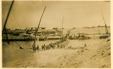
Postcard, Crossing the Suez via Pontoon Bridge, 1915
During WWI some AIF soldiers were located at the Suez in Egypt.Postcard with sepia photograph of Suez canal with soldiers crossing a pontoon bridge.Verso: "POST CARD" at centre top, "Correspondence" LHS top and "Address" RHS top "No 2" in black ink handwritten on top LHS corner. Handwriting blacked out on centre. "crossing the Suez via Pontoon Bridge" in pencilsuez, soldiers, wwi, world war one, canal, pontoon bridge, holmes, anzac -
 Phillip Island and District Historical Society Inc.
Photograph, Phillip Island Bridge, 1968/9
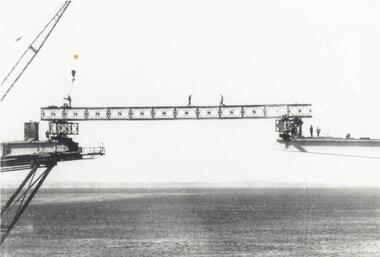
1969 Phillip Island Bridge under construction. From the Jack Jenner Collection.Joining Girder between two sides of new Bridge. Part of crane shown. Men on the girder and each side.local history, photographs, civil engineering, bridges, phillip island bridge under construction, black & white photograph, jack jenner collection, phillip island bridges, public construction -
 Phillip Island and District Historical Society Inc.
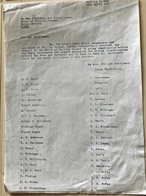
Document, Petition for bridge between Phillip Island and San Remo 1937
On 29 November 1940, a suspension bridge opened between San Remo on the mainland and with Newhaven on Phillip Island. The 540 metre bridge had two lanes but no footpaths, instead having six pedestrian refuges. The main span was 168 metres long. The cables had previously been used on a bridge on Sydney's North Shore. Because of weight restrictions, tourist coaches had to offload their passengers. [Wikipedia]HistoricalFoolscap size photocopy of a petition to Shire of Phillip Island for a bridge to Phillip Island in 1937. Signed by 42 local residents and ratepayers.first phillip island bridge to san remo, phillip island suspension bridge, petition, odlum, ockleford, regos, mcguigan, west, mcfee, richardson, underdown, mcmaster, cleeland, neely, leeson, saunders, scott, brown, hislop, donnellan, rackham, findlay, anderson -
 Federation University Historical Collection
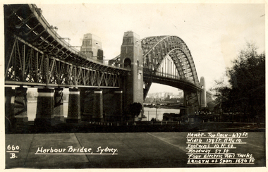
Postcard, Kodak, Sydney Harbour Bridge, c1949, 13/10/1949
Postcard written by Frank Wright to a friend, W. Snelling in London. Frank Wright was a renown resident of Smeaton, where he was born. He lived at Laura Villa, and attended Smeaton State School. His father William was a gold miner and his mother's name was Sarah. Their family won many singing and instrumental awards. Frank was tutored by Percy Code and was awarded a gold medal for the highest marks in the ALCM examinations in the British Colonies at the age of seventeen years. He became the Australian Open Cornet Champion by the age of eighteen. A year later, Frank conducted the City of Ballarat Band, and later the Ballarat Soldiers’ Memorial Band. He formed the Frank Wright Frisco Band and Frank Wright and his Coliseum Orchestra. These bands won many South Street awards, and Frank as conductor won many awards in the Australian Band Championship contest. In 1933 Frank Wright sailed to England to conduct the famous St Hilda’s Band and was later appointed Musical Director of the London County Council, where he organized many amazing concerts in parks, in and around the London district. He was made Professor of Brass and Military Band Scoring and conducted at the Guildhall of Music and Drama. Frank was often invited to adjudicate Brass Band Championships around Europe, in Australia, including South Street and in New Zealand. The Frank Wright Medal at the Royal South Street competition is awarded to an individual recognized as making an outstanding contribution to brass music in Australia.Black and white photograph of the Sydney Harbour Bridge. A small section of the city and water can be seen beneath the arched span of the bridge.Written in white on front - 660.B, Harbour Bridge, Sydney., Height-Top arch - 437 ft.,Width 159 ft. 11 3/4 in., Footways 10 ft. ea., Roadway 57 ft., Four Electric Rail Tracks., Length of span 1650 ft. Handwritten on back - Message to W. Snelling in London from Frank Wrightfrank wright, cornet, conductor, sydney harbour bridge -
 Ballarat Heritage Services
Photograph - Photograph - Colour, The Edna Walling Bridge at Locarno Spring in the Hepburn Springs Reserve, 2020, 12/12/2020
The Hepburn Springs Progress Association invited Edna Walling the the Hepburn Springs Reserve, and sandstone paths and bridges resulted. In 1934 there was a proposal to spend 2,000 to 3,000 poinds at the Hepburn Springs Reserve, with a govenrment loan suggested. Colour photograph of the stone bridge at Locarno Spring in the Hepburn Springs Reserve.hepburn springs, locarno, mineral water, hepburn springs reserve, locarno spring, edna walling -
 Orbost & District Historical Society
black and white photograph, July 1922
A new bridge over the Snowy River at Orbost was opened for traffic on June 20th 1922. It was designed for future joint use by road and railway traffic, but it was only used for road traffic. During the last few years the condition of an old suspension bridge [the 1893 bridge] which was the only vehicular crossing between the town of Orbost and the railway station, caused much concern. The structure was of timber, except for the wire suspension cables of its central span of about 100 feet. A design was prepared in 1914 for a permanent bridge with five spans of 85 feet composed of plate girders on concrete piers. With great increase in the price of steel work during the war, the cost of this design became prohibitive, and the need for a new structure becoming urgent, alternative proposals were investigated. As a result the present design was adopted as providing a sem-permanent bridge at moderate cost. The new bridge spans the river about 160 feet upstream from the old bridge on a slight skew, the piers being at an angle of 80 degrees with the centre line of the bridge. It has a camber of about 2 feet 5 inches in its total length of 527 feet. ( information from Newsletter March 2014 - Lois Crisp) The photograph shows Mrs James Cameron cutting the ribbon at the opening of the Orbost Pile Bridge in 1922. This second bridge, was built by the Victorian Railways and the Country Roads Board. Constructed at a cost of 35,000 pounds and used second-hand girders from the Flinders Street- Spencer Street viaduct. On July 4 1922 it was officially opened by Mrs James Cameron. Unfortunately, her husband, who had long championed the building of the bridge so that it would be ready for the railway to continue to the border, was too ill to attend the ceremony. In fact, James Cameron died on July 13 after a long and severe illness (ref. S.R.M. 20.7.1922). There is a section of this ribbon in the collection - Registration No. 366. This is a pictorial record of a significant event in Orbost's history.A black / white photograph of a pile bridge with a suspension bridge behind it. There are many people standing on the bridge.on back - "Opening of Pile Bridge - 1922"snowy-river-bridge ceremonies cameron-mrs -
Greensborough Historical Society
Family History, The adventured of the Brown brothers on the playing fields of Greensborough by Val Wilson (nee Rolfs), 1890o
... The adventured of the Brown brothers on the playing fields ...Val Wilson (nee Rolfs) recounts the problems faced by the Brown brothers in their quest to play cricket for Greensborough Cricket Club in the late 1800s.This story is supported by articles in the Evelyn Observer.3 typed pages.val wilson, val rolfs, greensborough cricket club, brown brothers, william brown, thomas brown, adam brown, henry brown, bundoora -
 Kew Historical Society Inc
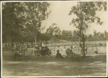
Photograph - Wading Pools : Studley Park Reserve
In the 1930s, the Studley Park Trust decided to cater for young children by constructing wading pools in the Studley Park Reserve where the Collins Bridge crosses into Kew. The earliest references to the pools in newspaper articles and letters to the editor appear in the late 1930s. The eventual closing date of the Studley Park Pools has not been discovered, but it was clearly still in existence in 1940 when a representative of the Trust described the facility as one of many public fixtures requiring regular maintenance. Black and white print positive of the former wading pools in the Studley Park Reserve (now Andrews Reserve) on the Kew side of the Collins Bridge. In the foreground adults are sitting on seats while small children play in the pools. The Abbotsford Convent is in the background.Reverse: "Collins Bridge / Wading pools Collins Bridge"andrews reserve -- kew, studley park trust, wading pools -- kew, studley park reserve -
Hume City Civic Collection
Photograph, Macedon Street Bridge, 1986
The photograph was taken showing the underside of the Macedon Street Bridge which spans the Jacksons Creek. It was constructed in the second half of the 1800s and replaced a pontoon that was used for river crossings.A non- digital black and white photograph of two arched bluestone bridge spanning a watercourse. -
 St Arnaud and District Historical Society
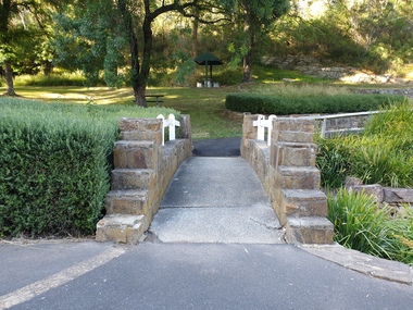
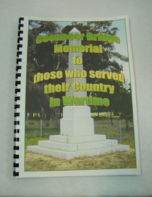
Book. Coonooer Bridge Memorial, Coonooer Bridge Memorial to those who served their Country in Wartime
Following the Great War of 1914-18 the people who lived in the general area around Coonooer Bridge , (18 kms from St.Arnaud ) erected a Monument in honour of those men and women who served their country in a time of war. In 1920 the monument was erected across from the hall, situated in a small pine plantation which was also planted by community members. The names of those that served their country during war time were placed on the monument. After the 2nd World War the names of the local men and women who once again were asked to serve their country were added to the memorial to honour and remember the sacrifice that they made.This book was compiled to honour and enable families and future generations to remember those who served.This is the only book listing these servicemen that served from the Coonooer Bridge Area.Spiral plastic bound book.Clear perspex cover. Coloured pages.Includes photographs of servicemen, medals and war service information.Dedicated to the people of Coonooer Bridge. -
 Kew Historical Society Inc
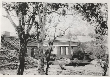
Photograph, Chandler Highway Bridge, 1930s
The railway viaduct linking the Outer Circle railway from Kew to Fairfield was constructed in the 1890s. In the 1930s it was converted into a motorway bridge.Photocopy of a photograph of the bridge linking Kew and Fairfield. Dated to the 1930s following the construction off the Chanler Highway.outer circle railway, viaduct (kew fairfield), john monash, chandler highway bridge -
 Phillip Island and District Historical Society Inc.
Photograph, Suspension Bridge, 1939-1940
Phillip Island's first Bridge for vehicular traffic under construction. Phillip Island Suspension Bridge under construction - angled view taken from San Remo with small boat at middle leftlocal history, photographs, civil engineering, bridges, phillip island - suspension bridge, black & white photograph, jack jenner collection, phillip island bridges, public construction -
 Eltham District Historical Society Inc
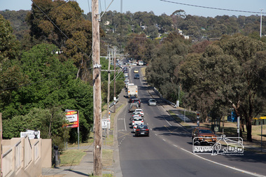
Photograph, Peter Pidgeon, North bound traffic routed down Bridge Street during Bolton Street upgrade, Eltham, 13 November, 2017, 13/11/2017
Born Digitalbolton street upgrade, eltham, streets, bridge street -
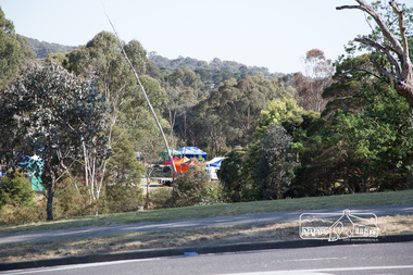 Eltham District Historical Society Inc
Photograph, Peter Pidgeon, The last of the marquees from the Eltham Festival being disassembled viewed from Bridge Street during Bolton Street upgrade, Eltham, 13 November, 2017, 13/11/2017
Born Digitalbolton street upgrade, eltham, streets, bridge street, eltham festival -
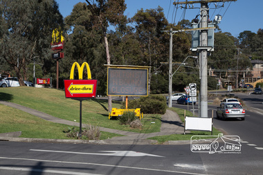 Eltham District Historical Society Inc
Photograph, Peter Pidgeon, McDonalds Restaurant, cnr Bridge Street and Bolton Street, Eltham, during Bolton Street upgrade, 13 November, 2017, 13/11/2017
North bound lane closureBorn Digitalbolton street, bolton street upgrade, eltham, streets, bridge street, mcdonalds restaurant