Showing 382 items matching "dandenong creek"
-
 Whitehorse Historical Society Inc.
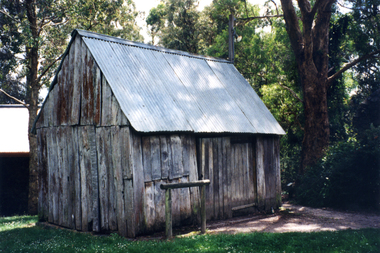
Photograph, Smithy's Shed, 1996
The Blacksmith's shop or 'Smithy' was erected from timbers found in a paddock in the Dandenong Ranges by Mr George Cox which were transported to the Cottage site and re-erected in 1970 on a part of the site where remains of a previous building had been found.Coloured photo of Blacksmith's Shedblacksmith, smithy, schwerkolt cottage -
 Whitehorse Historical Society Inc.
Photograph, Jones Flower Farm
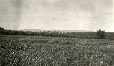
Jones Family Collection - NP2565 to NP2606. See also ND3831.Black and white photograph of daffodils growing on Jones' Flower Farm in Mt Pleasant Road, Nunawading, looking towards the Dandenongs with Mitcham Road in middle distance.jones, bette, walter, rolf, geoffrey, arthur, keith, lionel, muriel, jones flower farm, mount pleasant road nunawading -
 Whitehorse Historical Society Inc.
Photograph, Jones Flower Farm
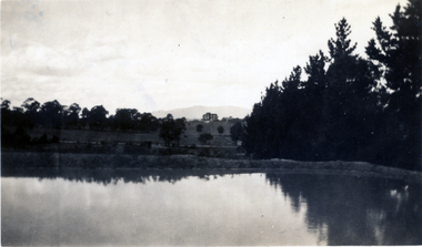
Jones Family Collection - NP2565 to NP2606. See also ND3831.Black and white photograph of water storage dam with the Dandenongs in the backgounnd - Jones' Flower Farm in Mt Pleasant Road, Nunawading, in 1928jones, bette, walter, rolf, geoffrey, arthur, keith, lionel, muriel, jones flower farm, mount pleasant road nunawading -
 Whitehorse Historical Society Inc.
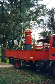
Photograph, Australia Post delivering Post Box, 1/09/2000 12:00:00 AM
This item was originally acquired by Harold Bakes, together with a Fire Hydrant Stand And a petrol pump , from the P.M.G. depot in Hawthorn in the 1970s . It was stored in the City of Nunawading Council yard in Station Street, Nunawading, and later loaned to the Australia Post Mail Exchange in Rooks Road, Nunawading. On the closure of the Mail Exchange, it was transferred to the Australia Post Museum in Dandenong. After proving ownership it was returned to back to the Society's Museum.Coloured photo of an Australia Post delivering restored Post Box to the Society's Implement Shedaustralia post, bakes, harold arthur -
 Whitehorse Historical Society Inc.
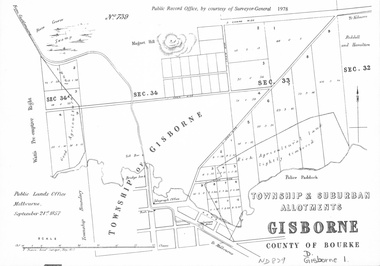
document - Map, Melbourne Metro, 1978
Collection of reproductions issued by the Public Record Office in 1978. Comprises: Allotments in the Black Forest, 1857; Township of Dandenong, 1856; Township and suburban allotments, Gisborne, 1857; Storing Yard allotments near the Melbourne Wharf, 1854; Town lots near the Railway Terminus, Melbourne, 1863; Parish of Prahran, 1853; Township of Sandridge, 1855; Township of Sunbury, 1857; River Yarra Yarra at the Queens Wharf, 1860.victoria. public record office, black forest, victoria, dandenong, gisborne, melbourne wharf, railway terminus, spencer street, melbourne, prahran, sandridge, sunbury, queens wharf -
 Whitehorse Historical Society Inc.
Document - Correspondence, Roads, 01/06/-/10/1933
Correspondence between shires of Blackburn and Mitcham, and Dandenong and City of Chelsea to declare Springvale Road a main road, June- October 1933.springvale road, nunawading, victoria. country roads board, shire of blackburn and mitcham, shire of dandenong, city of chelsea, roads and streets -
 Whitehorse Historical Society Inc.
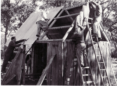
Photograph, Schwerkolt Cottage Building the Blacksmith's Workshop, 1969
Black and white photo of Nunawading Apex Club members rebuilding barn moved from Dandenong to Schwerkolt Cottage. Now blacksmith's forge. 3 copies)schwerkolt cottage, apex club dandenong -
 Whitehorse Historical Society Inc.
Photograph, Schwerkolt Cottage Building the Blacksmith's Workshop, 1969
Black and white photo of Nunawading Apex Club members erecting barn moved from the Dandenong Ranges to Schwerkolt Cottage. Now blacksmith's forge. 2 copiesschwerkolt cottage, apex club dandenong -
 Whitehorse Historical Society Inc.
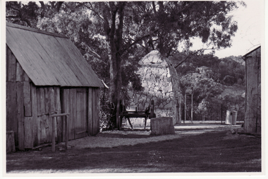
Photograph, Schwerkolt Cottage
The Blacksmith's shop or 'Smithy' was erected from timbers found in a paddock in the Dandenong Ranges by Mr George Cox which were transported to the Cottage site and re-erected in 1970 on a part of the site where remains of a previous building had been found.Black and white photo of Smokehouse and Smithy at Schwerkolt Cottageschwerkolt cottage, smokehouse, smithy, blacksmith forge -
 Whitehorse Historical Society Inc.
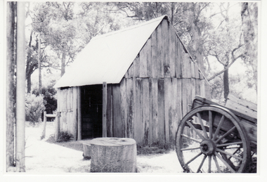
Photograph, Schwerkolt Cottage, 1973
The Blacksmith's shop or 'Smithy' was erected from timbers found in a paddock in the Dandenong Ranges by Mr George Cox which were transported to the Cottage site and re-erected in 1970 on a part of the site where remains of a previous building had been found.Black and white photo of Blacksmith's shop at Schwerkolt Cottageschwerkolt cottage, smithy, blacksmith's -
 Whitehorse Historical Society Inc.
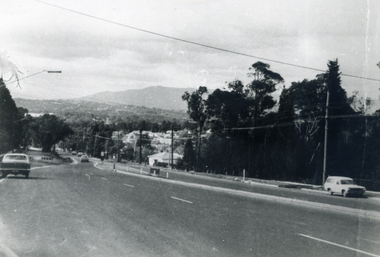
Photograph, Canterbury Road, C.1960s
Black and white photo of Canterbury Road looking towards Mt. Dandenongcanterbury road -
 Mt Dandenong & District Historical Society Inc.
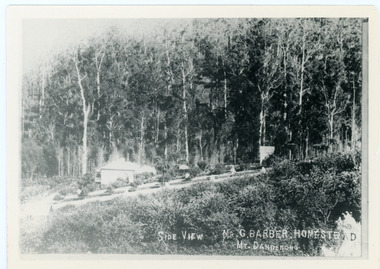
Photograph, Side View Mr G. Barber Homestead Mt Dandenong, c1905
Built in 1898 by early settler George Barber the property is still in existence today. It was the home of George, wife Sarah Ann and daughter Ethel.Black and white photograph showing te side view of George Barber's home, later named Forest Edge. c1905. Reverse of photograph has handwritten description by John Lundy-Clarke.Barber's home on Olinda Creek. Lot 25 Sect 1 Village Settlement. Home of George Barber and wife Sarah Ann (nee Richardson). Daughter Ethel.Was bought by Munnerley later Sangster and Kinnear. Later known as Forest Edge. Buggy and wagon shed on right. Photo copied 1973 by JLC. -
 Mt Dandenong & District Historical Society Inc.
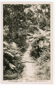
Photograph, Tourist Track, Sassafras. Vic, c1920
The tourist track running alongside the creek from Sassafras Mechanics’ Hall to Emerald. In the early 1900s the track started at Rostrevor Guest House.Black & White postcard P1501 from the Rose Series. Shows a log bridge along a tree fern lined section of the Tourist Track.On reverse - POST CARD A Real Photograph. Produced in Australia.rose series, sassafras, track, postcard, mechanics' hall -
 Mt Dandenong & District Historical Society Inc.
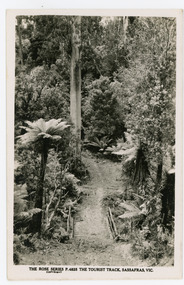
Photograph, The Tourist Track, Sassafras. Vic, c1920
The tourist track running alongside the creek from Sassafras Mechanics’ Hall to Emerald. In the early 1900s the track started at Rostrevor Guest House.Black and white photograph. Rose Series P. 4825 postcard showing a footbridge along a Tourist rack surrounded by bush and tree ferns.rose series, rostrevor, mechanics' hall, sassafras, track -
 Mt Dandenong & District Historical Society Inc.
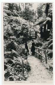
Photograph, Sassafras Gully, Victoria, c1920
The tourist track running alongside the creek from Sassafras Mechanics’ Hall to Emerald. In the early 1900s the track started at Rostrevor Guest House.Black and white copy of Rose Series Post card P. 74 showing two young women standing on a footbridge at Sassafras Gully. A set of steep steps can be seen above them.rose series, track, footbridge, bridge, sassafras -
 Mt Dandenong & District Historical Society Inc.
Photograph, The Tourist Track, Sassafras.Vic, c1920
The tourist track running alongside the creek from Sassafras Mechanics’ Hall to Emerald. In the early 1900s the track started at Rostrevor Guest House.Black and white Rose Series postcard P. 4832 showing a section of the Tourist Track in Sassafras surrounded by tree ferns and bush.On Reverse POST CARD A Real Photograph. Produced in Australia.sassafras, rose series, postcard, track -
 Mt Dandenong & District Historical Society Inc.
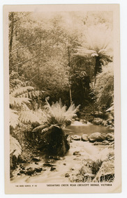
Photograph, Sassafras Creek Near Crescent Bridge. Victoria
Rose Series post card # P. 90. Sassafras Creek near The Crescent Bridge. View of water and ferns. Post 1920.Rose Series sepia coloured post card showing a small creek running through the centre of the photo edged by rocks and tree ferns.On front: The Rose Series, P. 90. SASSAFRAS CREEK NEAR CRESCENT BRIDGE. VICTORIA.sassafras creek, crescent bridge, creek, bridge, tree ferns, rose series, post card -
 Mt Dandenong & District Historical Society Inc.
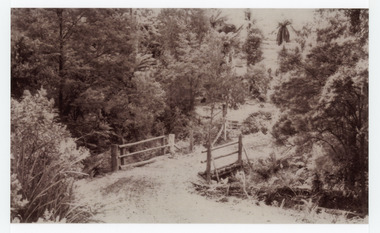
Photograph, Crescent Bridge Sassafras
The Crescent Bridge crossing Sassafras Creek on 'The Crescent' at Sassafras. View of water and ferns. c1912Black and white copy of a post card a bridge with a bush and tree fern background.On front: Crescent Bridge Sassafrassassafras, crescent bridge, the crescent, tree ferns, bridge -
 Mt Dandenong & District Historical Society Inc.
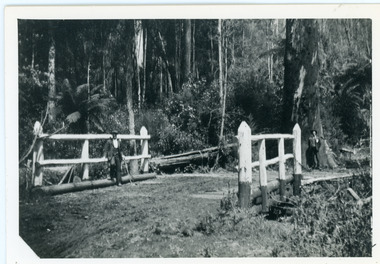
Photograph, The Crescent Bridge, Sassafras
Photograph taken at the bottom of the hill on 'The Crescent' at Sassafras where the Crescent Bridge crosses the Sassafras Creek.Black and white cop of a photograph showing a bridge crossing an unmade road over creek. Bush in background.sassafras, sassafras creek, crescent bridge, bridge, the crescent, bush, tree ferns -
 Mt Dandenong & District Historical Society Inc.
Photograph, Barber's Bridge on Olinda Creek
John Lundy-Clarke grew up in the Kalorama/Mt Dandenong area and later in life (1972-74) began to write a comprehensive history of the area working from an original settlement map in an effort to cover all areas. Barbers Bridge was named after George Barber, an early settler.Black and white photograph showing a man standing on a bridge over the Olinda Creek. 1910Handwritten n reverse: Barbers Bridge on Olinda Creek 1910. This was a ford crossed by the road after Isaac Jeeves selected allotment “C” “Jeeves Saddle” in 1871 and stopped travel through his property. The bridge has been built several times but at time of writing (1974) is replaced by a culvert consisting of two pipes two feet six inches wide. They are quite incapable of carrying the maximum flow of the creek and will be swept away.lundy-clarke, barber, barbers bridge, isaac jeeves, jeeves saddle, bridge, olinda creek -
 Mt Dandenong & District Historical Society Inc.
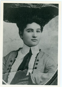
Photograph, Doris Child
John Lundy-Clarke grew up in the Kalorama/Mt Dandenong area and later in life (1972-74) began to write a comprehensive history of the area working from an original settlement map in an effort to cover all areas. William Lucas , who came from England to visit Matthew Child in the late 1870s. He purchased land from Matthew and married his daughter Catherine. They developed their property as the sporting lodge 'Glenrivers'. Their daughter Dorothea was born in 1888. She was an accomplished horsewoman who married her cousin Charles Percival (Percy) Child in 1917. Percy worked a sawmill on the creek .Black and white copy of studio portrait of Doris (Dorothea) Child (nee Lucas).Handwritten by John Lundy-Clarke on reverse: Doris Lucas “Dorothea?” Daughter of W Lucas and Catherine nee Child. Wife of Percy Child. Mother of Lois. Born 1889 died 1936 (?)dorothea lucas, dorothea child, percy child, matthew child, william lucas, catherine child -
 Mt Dandenong & District Historical Society Inc.
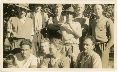
Photograph, Clint Rowse and Staff
John Lundy-Clarke grew up in the Kalorama/Mt Dandenong area and later in life (1972-74) began to write a comprehensive history of the area working from an original settlement map in an effort to cover all areas. John Lundy-Clarke has identified the photograph as being of Clint Rowse and Staff at Olinda Creek Valley in 1939. The workmen are: Back row from right: Bob Daly, Dud Page, Harry Dyson, Bill Cavell, Len Child, Ken Williams. Front row from right: Clint Rowse, Jack Clarke, Bernie Page, Jack Johnson (with dog). The Rowse family had extensive raspberry crops but later changed to flowers. Daisy Rowse married Hubert Jeeves. Black and white photograph showing a group of 10 workmen, one holding a dog.The names Lenny Child, Dyson, Page, Bob Daly, Jackie Johnston, J Clarke, Clint Rowse are handwritten on the back by John Lundy-Clarkelen child, bob daly, clint rowse, jack johnston, bill cavell, ken williams, jack clarke, dud page, bernie page -
 Mt Dandenong & District Historical Society Inc.
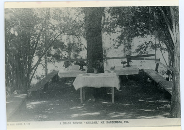
Photograph, Tea Tables at "Shiloah"
Originally the home of Isaac Jeeves, brother of Ellis Jeeves, ‘Shiloah’ was enlarged to take guests in the early 1900s. It was situated close to a beautiful fern gully and Isaac and his family capitalised on this by setting out walking tracks through the ferns. They charged 1/- to walk through and this included afternoon tea in a garden setting. ‘Shiloah’ was a popular tourist attraction but the making of the Olinda Creek Road destroyed the fern gullies and, by the 1930s, it was all finished. This photograph shows the tea tables at 'Shiloah' where Selina Jeeves and her daughter Elsie served afternoon tea to visitors.Black and white photograph taken from a Rose Series postcard showing tables set up in an exterior courtyard with bench seating.On front - Rose Series P. 170 A SHADY BOWER "SHILOAH" MT DANDENONG. VIC.shiloah, isaac jeeves the younger, guest house, afternoon tea, ferns, selina jeeves, elsie jeeves -
 Mt Dandenong & District Historical Society Inc.
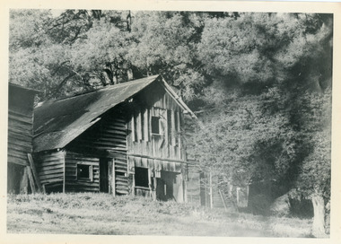
Photograph, Isaac Jeeves' Barn
Large barn built c1886 by Isaac Jeeves the younger on his property where the homestead 'Shiloah' stood. The barn was reputedly made from timbers split from only one messmate tree. Originally the home of Isaac Jeeves, brother of Ellis Jeeves, ‘Shiloah’ was enlarged to take guests in the early 1900s. It was situated close to a beautiful fern gully and Isaac and his family capitalised on this by setting out walking tracks through the ferns. They charged 1/- to walk through and this included afternoon tea in a garden setting. ‘Shiloah’ was a popular tourist attraction but the making of the Olinda Creek Road destroyed the fern gullies and, by the 1930s, it was all finished. John Lundy-Clarke grew up in the Kalorama/Mt Dandenong area and later in life (1972-74) began to write a comprehensive history of the area working from an original settlement map in an effort to cover all areas.Black and white photograph showing a large wooden structure surrounded by trees. Handwritten inscription on reverse by John Lundy-Clarke.Home of Isaac Jeeves the younger. Built about 1886 of timbers split from one messmate tree. Photo 1973isaac jeeves the younger, barn, kalorama, shiloah, messmate -
 Mt Dandenong & District Historical Society Inc.
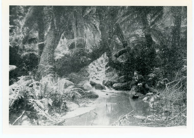
Photograph, The Olinda Creek, 1910
... -and-the-dandenong-ranges The Olinda Creek in 1910. Most probably ...The Olinda Creek in 1910. Most probably in the gully behind the house of George Barber.Black and white photograph with a creek running through the centre of ferns and tree ferns. A man sits beside the creek on the RHS.olinda creek -
 Mt Dandenong & District Historical Society Inc.
Photograph, The Olinda Creek, 1910
... -and-the-dandenong-ranges The Olinda Creek, 1910 Photograph Photograph ... -
 Mt Dandenong & District Historical Society Inc.
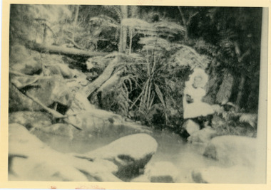
Photograph, The Olinda Creek, 1910
Taken in 1910, this section of the Olinda Creek is in the gully behind the home of George Barber.Black and white photograph with a creek running through the centre surrounded by ferns and tree ferns. A man is leaning on rocks beside the creek on the RHS.olinda creek, creek, george barber, tree fern -
 Mt Dandenong & District Historical Society Inc.
Photograph, Jessie Wyles at Emerald Creek
... -and-the-dandenong-ranges emerald creek jessie wyles Emerald Creek Emerald ...Young girl in a white pinafore and large, white hat sitting on a rock at the edge of Emerald Creek. Reverse of photograph has handwritten description by John Lundy-Clarke.Emerald Creek Emerald Creek with Jessie Wylesemerald creek, jessie wyles -
 Mt Dandenong & District Historical Society Inc.
Photograph, 'Hillcrest' on Mernda Road, Olinda 1911, 1911
Front view of 'Hillcrest' the Devine family home on Mernda Road, Olinda taken in 1911. The road deviation passed to the right of where the photographer was standing. The descriptive text on the reverse of this photograph was hand written by John Lundy-Clarke.“Hillcrest” the home of the Devine family 1911 in Mernda Road now Coonara Road. The road was deviated here to regrade it and the deviation past to the right of the camera. The house fronted down over the valley of the Sassafras Creek towards Kallista. It was close to the spot where the camera stood that the girls practiced the maypole dance in 1911. Vera Devine trained 11 of her mates in the dance here.hillcrest, mernda road, olinda, vera devine, devine family -
 Mt Dandenong & District Historical Society Inc.
Photograph, c1911
"Hillcrest" on Mernda Road, Olinda. The home of the Devine Family. c1911 The descriptive text on the reverse of this photograph was hand written by John Lundy-Clarke.“Hillcrest” Mernda Road Olinda 1911. The home of the Devine family. The early settlement road passed to the left of the camera. House faced down over the valley of the Sassafras + Perrin Creek towards Kallista. The deviation to regrade the road passed to the right of the house. It was in front of the house on the left hand side of the picture that Vera Devine and her school mates practiced the maypole dance under her tuition. hillcrest, devine, devine family, mernda road