Showing 8432 items matching "dandenong ranges"
-
 Upper Yarra Museum
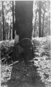
Negative Photographic Reproduction, H. Lepoidevin falling a tree Early 1920s Hoddles Creek
... Highway Yarra Junction yarra-valley-and-dandenong-ranges h ...H. Lepoidevin falling a tree Early 1920s Hoddles Creek Negative Black white Scanned at 600 dpi.h lepoidevin falling tree hoddles creek early 1920s -
 Upper Yarra Museum
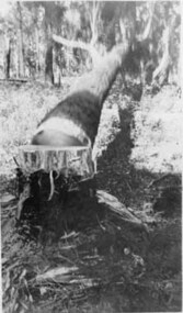
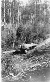
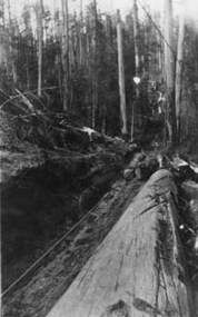
Negative Photographic Reproduction, The fallen tree Early 1920s Hoddles Creek
... Highway Yarra Junction yarra-valley-and-dandenong-ranges fallen ...The fallen tree Early 1920s Hoddles Creek Negative Black white Scanned at 600 dpi.fallen tree hoddles creek early 1920s -
 Upper Yarra Museum
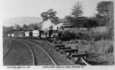
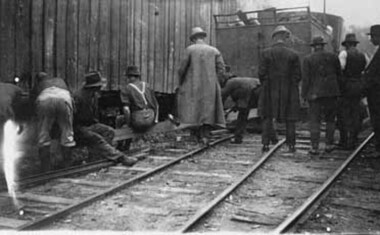
Negative Photographic Reproduction, Bridge over Yarra at the Doon, 1911, Yarra Junction
... Highway Yarra Junction yarra-valley-and-dandenong-ranges PC ...PC Valentine 2650 Powelltown timber train at Yarra Junction Negative Black white Scanned at 600 dpi. -
 Upper Yarra Museum
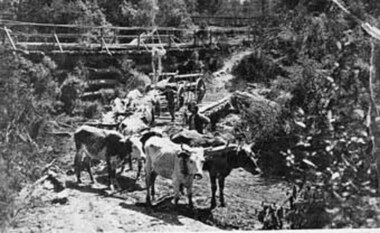
Negative Photographic Reproduction, Bullock team at Yarra Junction
... Highway Yarra Junction yarra-valley-and-dandenong-ranges bullock ...Bullock team at Yarra Junction Negative Black white Scanned at 600 dpi.bullock team carts bridge yarra junction -
 Upper Yarra Museum
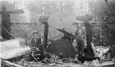
Negative Photographic Reproduction, Large logs coming down a tramline
... Highway Yarra Junction yarra-valley-and-dandenong-ranges large ...Large logs coming down a tramline Negative Black white Scanned at 600 dpi.large logs tramline brakeman -
 Upper Yarra Museum
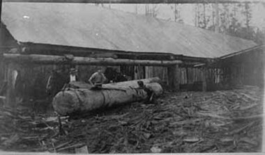
Negative Photographic Reproduction, Mc Crae Creek Mill Beenak, 2.10.1983
... Highway Yarra Junction yarra-valley-and-dandenong-ranges mc crae ...Mc Crae Creek Mill Beenak Negative Black white Scanned at 600 dpi.mc crae creek mill beenak -
 Upper Yarra Museum
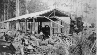
Negative Photographic Reproduction, Working on a log at a mill Hoddles Creek
... Highway Yarra Junction yarra-valley-and-dandenong-ranges working ...Working on a log at a mill Hoddles Creek Negative Black white Scanned at 600 dpi.working log mill hoddles creek -
 Upper Yarra Museum
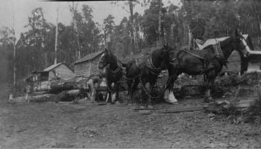
Negative Photographic Reproduction, Working with horses at Mc Crae Creek mill 1945 Beenak
... Highway Yarra Junction yarra-valley-and-dandenong-ranges working ...Working with horses at Mc Crae Creek mill 1945 Beenak Black and White negative scanned at 600 dpiworking horses mc crae creek mill beenak 1945 -
 Upper Yarra Museum
Negative Photographic Reproduction, Three Bridges, 2.10.1983
... Highway Yarra Junction yarra-valley-and-dandenong-ranges three ...Three Bridges Black and White negative scanned at 600 dpithree bridges powellite tow -
 Upper Yarra Museum
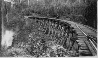
Negative Photographic Reproduction, The Powelltown tramline bridge
... Highway Yarra Junction yarra-valley-and-dandenong-ranges ...The Powelltown tramline bridge Black and White negative scanned at 600 dpipowelltown tramline bridge -
 Upper Yarra Museum
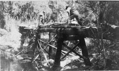
Negative Photographic Reproduction, Workers repairing or constructing a tramway bridge
... Highway Yarra Junction yarra-valley-and-dandenong-ranges workers ...Workers repairing or constructing a tramway bridge Black and White negative scanned at 600 dpiworkers repair contructing tramway bridge -
 Upper Yarra Museum
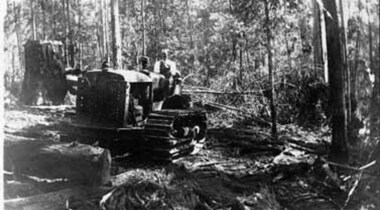
Negative Photographic Reproduction, Bulldozer working at Mc Crae Creek mill 1945
... Highway Yarra Junction yarra-valley-and-dandenong-ranges buldozer ...Bulldozer working at Mc Crae Creek mill 1945 Black and White negative scanned at 600 dpibuldozer working mc crae creek mill 1945 -
 Upper Yarra Museum
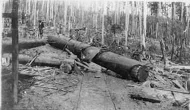
Negative Photographic Reproduction, Workers winching a log at Pioneer Creek
... Highway Yarra Junction yarra-valley-and-dandenong-ranges workers ...Workers winching a log at Pioneer Creek Black and White negative scanned at 600 dpiworkers winching log pioneer creek -
 Upper Yarra Museum
Negative Photographic Reproduction, An old mill site
... Highway Yarra Junction yarra-valley-and-dandenong-ranges old mill ...An old mill site Black and White negative scanned at 600 dpiold mill site -
 Upper Yarra Museum
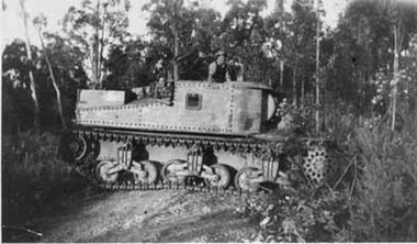
Negative Photographic Reproduction, George (Mick) Worlley’s Grant tank used for clearing scrub 1952 Hoddles Creek
... Highway Yarra Junction yarra-valley-and-dandenong-ranges George ...George Worlley bought a Grant Tank from Bandiana for clearing scrub and falling trees for the mill in 1952George (Mick) Worlley’s Grant tank used for clearing scrub 1952 Hoddles Creek Black and White negative scanned at 600 dpi Check no -
 Upper Yarra Museum
Negative Photographic Reproduction, Winching a log
... Highway Yarra Junction yarra-valley-and-dandenong-ranges winching ...Winching a log Black and White negative scanned at 600 dpiwinching log -
 Upper Yarra Museum
Green Gables Letter Box, Unknown
... Highway Yarra Junction yarra-valley-and-dandenong-ranges This item ...This item was used in the office of Green Gables, Guest House, Warburton, to hold post cards, that were sold to the guests. The Kent Family owned and operated the House from 1949 -1957, this item was kept by the family until 2013.It was then donated to the Upper Yarra Museum.Wooden hardwood, Letter holder, back 28 cm high,13 cm wide.7 cms. deep. 2 compartments inner compartment 20cm. high. Front is 9 cms. with inscription.Stenstil sign in gold with black outline. This is on the lower front panel green gables, warburton, -
Upper Yarra Museum
senior fellowship powelltown union church, 30 july 1934
... Highway Yarra Junction yarra-valley-and-dandenong-ranges ...The exercise book contains meeting minutes from the Powelltown Union Church Senior Fellowship.The first minutes are from July 30 1934, the last from 15/7/36. The Fellowship's Rules are listed near the back of the book.The Powelltown Church was an unusual Union Church. Fellowship members listed in the minutes have links with original and recent residents.The minutes provide primary insights into the Powelltown community,Fellowships and contemporary matters. Front and back covers provide examples of contemporary advertisements.ruled exercise book green coloured ads un front and back covers l230mmxw180mmmiss marion adams secty warburton yarra junction powelltown. union church. senior fellowships.advertisements. warburton. yarra junction. district state schhols -
Upper Yarra Museum
Wooden Serviette holder individual x 6 painted Australian motifs, Unknown
... Highway Yarra Junction yarra-valley-and-dandenong-ranges This item ...This item was used at the Mayer Chalet, Warburton .In the Dinning room. the Marysville Historical Society donated to The Upper Yarra Museum in 2013The Chalet was burnt down.Wooden Serviette holder turned wood, light and dark in colour. Hand painted from Mayer Chalet. number 1. painted tree and fence with mountains in the back groundmayer chalet, warburton -
Upper Yarra Museum
Wooden Serviette holder
... Highway Yarra Junction yarra-valley-and-dandenong-ranges Used ...Used by the Mayer Chalet, WarburtonWooden Serviette Holder, made of two tone wood. with hand painting on the sideKookaburra on a green branch, with creme writing "From Mayer Chalet"serviette holder, mayer chalet -
Upper Yarra Museum
Wooden Serviette holder
... Highway Yarra Junction yarra-valley-and-dandenong-ranges Used ...Used by The Mayer Chalet, Warburton.Wooden two tone, serviette Holder, hand painted on the sideTwo Mountain Ash Gum trunks in fore ground with blue mountains another tree in the background. In creme writing "From Mayer Chalet"serviette holder, mayer chalet -
Upper Yarra Museum
Serviette holder
... Highway Yarra Junction yarra-valley-and-dandenong-ranges Used ...Used at the Mayer Chalet, Warburton.Wooden Serviette holder made from 2 tone wood.with hand painting on the sideRed Gum flowers with green gum leaves hanging down, creme writing "From Mayer Chalet"serviette holder, mayer chalet -
Upper Yarra Museum
Serviette holder
... Highway Yarra Junction yarra-valley-and-dandenong-ranges Used ...Used by the Mayer Chalet, WarburtonWooden Serviette holder made of two tone wood, with hand painting. Four blue flowers, two small groups of pink flowers and a small number of green leaves. Creme writing "From Mayer Chalet"serviette holder, mayer chalet -
 Eltham District Historical Society Inc
Photograph, Fay Bridge, Moor-rul Viewing Platform, Garden Hill, Kangaroo Ground, n.d
OPENING OF THE VIEWING PLATFORM AT KANGAROO GROUND Nillumbik Council has advised that the viewing platform at Kangaroo Ground 27km NE of Melbourne is to be opened to the public on Wednesday, March 26th 2008 (Melway 271 , G10). The function of the platform is to provide shelter adjacent to the War Memorial Tower whilst allowing all people to enjoy the stunning panoramic views. From the platform you. can see the Dandenongs, the city of Melbourne, the You Yangs, Mount Macedon, the Kinglake Ranges and the Mt Baw-Baw Ranges where the Yarra River starts. This landscape covers all the ancestral lands of the Wurundjeri and some of the wider Kulin nation land. The platform has been given the name Moor-rut, a name which described the fertile soils of the Kangaroo Ground area in contrast to the poorer (Silurian) country of its surrounds, which the Wurundjeri knew as 'Nillumbik' or less rich country. The full 360 degree view can be seen from the adjacent Tower of Remembrance which has 53 stairs. The viewing platform however can be accessed by wheelchair. Inside the viewing platform there are eight double sided interpretive panels giving the history and information regarding this special area. The viewing platform's interpretive panels set out the Aboriginal and European history of the area and also the geology and the local flora and fauna, so that the casual visitor comes away understanding more about this significant part of Victoria. The concept of the viewing platform is part of the refurbishment project for the Kangaroo Ground War Memorial Park which has taken place since 1997 with the active approval and financial assistance of the Nillumbik Shire Council. This project has been guided by an Advisory Committee with volunteer community representatives from the local Historical Societies, the Country Fire Authority, the Returned Services League and the Wurundjeri people. Other allied groups such as the Nillumbik Reconciliation Group have been called upon for their expertise. The initial idea for the viewing platform came from Dean Stewart when he was the caretaker while living at the park. He discussed this idea with local author Mick Woiwod and Harry Gilham of Eltham District Historical Society when they were planning the refurbishment of the War Memorial Park in 1996. When the committee was formalised by the Nillumbik Council in 1997, Nicholas Pelling, representing the CFA and RSL, joined the group. Dennis Ward, local architect, then volunteered to develop the concept plan for the refurbishment of the park and later drew up the plans for the viewing platform. The Kangaroo Ground War Memorial Park and its Tower of Remembrance is located on one of the highest locations in the Yarra Valley. The Tower of Remembrance is a unique war memorial constructed from local stone standing 14 metres high. It was built in the style of a Scottish watchtower reflecting the strong Scottish influence of the first European settlers of the district from the 1840s onward. The park was opened in 1921 and the Tower of Remembrance was dedicated in 1926 recognising the local people who served in the First World War. Those who served in the Second World War were recognised by plaques dedicated in 1951 and more recently those who served in Korea, Borneo, Malaya and Vietnam by plaques unveiled in 2001. Harry Gilham, Advisory Committee Convenor - Eltham District Historical Society Newsletter N0 179 March 2008fay bridge collection, garden hill, kangaroo ground, memorial park, moor-rul viewing platform -
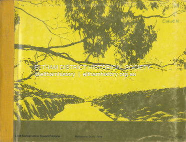 Eltham District Historical Society Inc
Book, Land Conservation Council, Report on the Melbourne Study Area, December 1973
This report is one of a series describings the physical nature of the land and its environment, examines the likely forms of land use, and assesses the hazards associated with these uses. It is divided into four main sections: Introduction, Characteristics of environment, main forms of land use and description of 24 specific blocks in the study area which include Torquay, Brisbane Ranges, Werribee, Wombat, Loddon, Romsey, Puckapunyal, Strathbogie, Eildon, Disappointment, Break O'Day, Black Range, Cerberean, Upper Goulburn, Kinglake, Donna Buang, Upper Yarra, Thomson, Dandenongs, Bunyip-Latrobe, Shady Creek, Tyers, Westernport and Strzelecki. The Land Conservation Act 1970 established the Land Conservation Council whose functions is to "carry out investigations and make recommendations to the Minister with respect to the use of public land in order to provide for the balanced use of land in Victoria. This report sets out to describe and assess the natural resources of the public lands in the Melbourne area and provides a factual basis on which members of the community may base submissions to the [Land Conservation] Council of Victoria.444 pagesnon-fictionThis report is one of a series describings the physical nature of the land and its environment, examines the likely forms of land use, and assesses the hazards associated with these uses. It is divided into four main sections: Introduction, Characteristics of environment, main forms of land use and description of 24 specific blocks in the study area which include Torquay, Brisbane Ranges, Werribee, Wombat, Loddon, Romsey, Puckapunyal, Strathbogie, Eildon, Disappointment, Break O'Day, Black Range, Cerberean, Upper Goulburn, Kinglake, Donna Buang, Upper Yarra, Thomson, Dandenongs, Bunyip-Latrobe, Shady Creek, Tyers, Westernport and Strzelecki. The Land Conservation Act 1970 established the Land Conservation Council whose functions is to "carry out investigations and make recommendations to the Minister with respect to the use of public land in order to provide for the balanced use of land in Victoria. This report sets out to describe and assess the natural resources of the public lands in the Melbourne area and provides a factual basis on which members of the community may base submissions to the [Land Conservation] Council of Victoria.land use, kinglake, thomson valley, conservation, public lands -
 Eltham District Historical Society Inc
Photograph - Black and White Print, Moor-rul Viewing Platform, March 2007
Early stages - no display panels installed. OPENING OF THE VIEWING PLATFORM AT KANGAROO GROUND Nillumbik Council has advised that the viewing platform at Kangaroo Ground 27km NE of Melbourne is to be opened to the public on Wednesday, March 26th 2008 (Melway 271 , G10). The function of the platform is to provide shelter adjacent to the War Memorial Tower whilst allowing all people to enjoy the stunning panoramic views. From the platform you. can see the Dandenongs, the city of Melbourne, the You Yangs, Mount Macedon, the Kinglake Ranges and the Mt Baw-Baw Ranges where the Yarra River starts. This landscape covers all the ancestral lands of the Wurundjeri and some of the wider Kulin nation land. The platform has been given the name Moor-rut, a name which described the fertile soils of the Kangaroo Ground area in contrast to the poorer (Silurian) country of its surrounds, which the Wurundjeri knew as 'Nillumbik' or less rich country. The full 360 degree view can be seen from the adjacent Tower of Remembrance which has 53 stairs. The viewing platform however can be accessed by wheelchair. Inside the viewing platform there are eight double sided interpretive panels giving the history and information regarding this special area. The viewing platform's interpretive panels set out the Aboriginal and European history of the area and also the geology and the local flora and fauna, so that the casual visitor comes away understanding more about this significant part of Victoria. The concept of the viewing platform is part of the refurbishment project for the Kangaroo Ground War Memorial Park which has taken place since 1997 with the active approval and financial assistance of the Nillumbik Shire Council. This project has been guided by an Advisory Committee with volunteer community representatives from the local Historical Societies, the Country Fire Authority, the Returned Services League and the Wurundjeri people. Other allied groups such as the Nillumbik Reconciliation Group have been called upon for their expertise. The initial idea for the viewing platform came from Dean Stewart when he was the caretaker while living at the park. He discussed this idea with local author Mick Woiwod and Harry Gilham of Eltham District Historical Society when they were planning the refurbishment of the War Memorial Park in 1996. When the committee was formalised by the Nillumbik Council in 1997, Nicholas Pelling, representing the CFA and RSL, joined the group. Dennis Ward, local architect, then volunteered to develop the concept plan for the refurbishment of the park and later drew up the plans for the viewing platform. The Kangaroo Ground War Memorial Park and its Tower of Remembrance is located on one of the highest locations in the Yarra Valley. The Tower of Remembrance is a unique war memorial constructed from local stone standing 14 metres high. It was built in the style of a Scottish watchtower reflecting the strong Scottish influence of the first European settlers of the district from the 1840s onward. The park was opened in 1921 and the Tower of Remembrance was dedicated in 1926 recognising the local people who served in the First World War. Those who served in the Second World War were recognised by plaques dedicated in 1951 and more recently those who served in Korea, Borneo, Malaya and Vietnam by plaques unveiled in 2001. Harry Gilham, Advisory Committee Convenor - Eltham District Historical Society Newsletter N0 179 March 2008 Black and white inkjet print on paper 14 x 21 cmmoor-rul viewing platform, garden hill, kangaroo ground, memorial park -
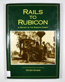 Marysville & District Historical Society
Book - Hardcover book, Peter Evans, Rails to Rubicon-A History of the Rubicon Forest, 1994
... Marysville yarra-valley-and-the-dandenong-ranges A history ...Hardcover. Green dust cover. Front cover photograph is Krauss 0-4-OWT, builder's No. 2459 of 1891, takes water at the western end of Rubicon Lane in 1934. Driver Bob Rees attends to his engine while brakeman Hayden looks on. End papers show a photograph of a man standing besides a timber railway trolley holding onto the brake lever. There is a group of men, some sitting and some standing, on piles of cut timber under a large, open shed in the background. There are also some small, timber, tent like structures standing next to the railway tracks. There is a forest in the far background. Written in white is the line "Mr Clarke & Kidd's Sawmill". non-fictionrubicon, timber, sawmill, railway, tramway, clarke and pearce, evans, peter, marysville, krause, forest, mountain -
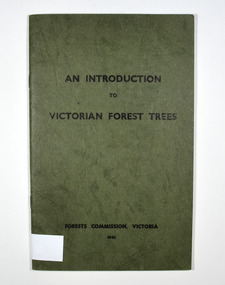 Marysville & District Historical Society
Book - Paperback book, An Introduction to Victorian Forest Trees, 1961
... Marysville yarra-valley-and-the-dandenong-ranges A history ...A history of forestry in Victoria Paperback. Cover is green with only the title on the front cover. On the inside back cover is a map of Victoria with the state forests indicated.Stamp of Marysville & District / Historical Society Inc / P.O. Box 22 / Marysville 3779victoria, forestry, forest, trees -
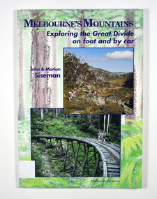 Marysville & District Historical Society
Book - Paperback book, Melbourne's Mountains-Exploring the Great Divide on foot and by car, 1993
... Marysville yarra-valley-and-the-dandenong-ranges Exploring the Great ...Exploring the Great Divide on foot and by carPaperback. Front and back covers have a painting of a forest as a background with photographs of mountains, an old trestle bridge and old machinery. Back cover also has a sinopsis of the book.Stamp of Marysville & District / Historical Society Inc / P.O. Box 22 / Marysville 3779great divide, walking, touring, mountains, victoria, tourism, siseman, john, siseman, marion -
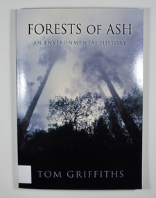 Marysville & District Historical Society
Book - Paperback book, Forests of Ash-An Environmental History, 2001
... Marysville yarra-valley-and-the-dandenong-ranges An environmental ...An environmental history of Victoria's Mountain Ash forestsPaperback. Front cover has a photograph of trees.Stamp of Marysville & District Historical Society Inc / P.O. Box 22 / Marysville 3779eucalyptus regnans, victoria, history, forests, forestry, mountain ash, griffiths, tom