Showing 524 items
matching department of lands
-
 Bendigo Historical Society Inc.
Map - SALISBURY : COUNTY OF BENDIGO, 1965
... at the Department of Lands and Survey, Melbourne. Price $1.00. 1965..., Yarrayne, Bullock Creek. Drawn and reproduced at the Department ...Map. Salisbury, County of Bendigo, Pompapiel, Yallook, Yarraberb, Yarrayne, Bullock Creek. Drawn and reproduced at the Department of Lands and Survey, Melbourne. Price $1.00. 1965. By authority A.C. Brooks, Government Printer, Melbourne. (number 28 in map cupboard 1)A.C. Brooks,Government Printer, Melbourne.map, bendigo, salisbury -
Bendigo Historical Society Inc.
Map - WANURP : COUNTY OF BENDIGO, 1-12-33
... Printer.Photo-Lithographed at the Department of Lands and Survey... at the Department of Lands and Survey, Melbourne. Price 2/-. 1-12-33 ...Map. Wanurp, County of Bendigo, Terrick Terrick East, Mitiamo, Milloo, Pannoobamawm. By authority H.J. Green, Government Printer.Photo-Lithographed at the Department of Lands and Survey, Melbourne. Price 2/-. 1-12-33. (number 9 in map cupboard 1)H.J. Green, Government Printermap, bendigo, wanurp -
Bendigo Historical Society Inc.
Map - TALAMBE : COUNTY OF BENDIGO, January 1956
... , Melbourne. Drawn and reproduced at the Department of Lands... and reproduced at the Department of Lands and Survey, Melbourne. January ...Map. Talambe, County of Bendigo, Hayanmi, Pompapiel, Dingee, Tandarra, Yallook. By authority W.M. Houston, Government Printer, Melbourne. Drawn and reproduced at the Department of Lands and Survey, Melbourne. January 1956. Price 2/-. (number 8 in map cupboard 1)W.M. Houston, Government Printermap, bendigo, talambe -
Bendigo Historical Society Inc.
Map - SALISBURY : COUNTY OF BENDIGO, 1965
... , Government Printer, Melbourne. Drawn and reproduced at the Department..., Melbourne. Drawn and reproduced at the Department of Lands ...Map. Salisbury, County of Bendigo, Pompapiel, Yarrayne, Yarraberb, Yallook, Bullock Creek. By Authority: A.C. Brooks, Government Printer, Melbourne. Drawn and reproduced at the Department of Lands and Survey, Melbourne.1965. Price $1.00. (number 6 in map cupboard 1)A.C. Brooks, Government Printermap, bendigo, salisbury -
Bendigo Historical Society Inc.
Map - DERBY : COUNTY OF BENDIGO, 1959
... at the Department of Lands and Survey, Melbourne. 1959. Price 2/-. (number..., Government Printer, Melbourne. Drawn and reproduced at the Department ...Map. Derby, County of Bendigo, Bridgewater, Inglewood, Tarnagulla, Woodstock, Leichardt, Loddon River. By authority A.C. Brooks, Government Printer, Melbourne. Drawn and reproduced at the Department of Lands and Survey, Melbourne. 1959. Price 2/-. (number 54 in map cupboard 1)A.C. Brooks, Government Printer, Melbourne.map, bendigo, derby -
Bendigo Historical Society Inc.
Map - YALLOOK : COUNTY OF BENDIGO, 30-1-28
... at the Department of Lands and Survey, Melbourne, Victoria. 30-1-28. H.J..., Salisbury, Pompapiel. Drawn and reproduced at the Department ...Map. Yallook, County of Bendigo, L4942, Talambe, Tandarra, Neilborough, Yarraberb, Salisbury, Pompapiel. Drawn and reproduced at the Department of Lands and Survey, Melbourne, Victoria. 30-1-28. H.J. Green, Govt. Printer, Melbourne. (number 18 in map cupboard 1)H.J. Green, Govt. Printer.map, bendigo, yallook -
Bendigo Historical Society Inc.
Map - COSTERFIELD : COUNTY OF BENDIGO, 31-10-12
... of Costerfield. Photo-Lithographed at the Department of Lands and Survey..., Heathcote, Town of Costerfield. Photo-Lithographed at the Department ...Map. Costerfield, County of Bendigo, County of Dalhousie, Dargile, Moorambool West, Warrowitue, Heathcote, Town of Costerfield. Photo-Lithographed at the Department of Lands and Survey, Melbourne, by W.J .Butson 31-10-12 price 1/-. (number 93 in map cupboard 1)W.J. Butsonmap, bendigo, costerfield -
University of Melbourne, Burnley Campus Archives
Plan, Plan of Richmond Park, 1872
... . Photo-lithographed at the Department of Lands and Survey, 6th..., Authorized Surveyor. Photo-lithographed at the Department of Lands ...Plan of Richmond Park L4461. Shows Horticultural Society's Garden without extra land used for Field Station (see 11.0363, but earlier). Surveyed and drawn by A.L. Martin, Authorized Surveyor. Photo-lithographed at the Department of Lands and Survey, 6th Sept. 1872.Handwritten notes on reverse and another railway line marked in pencil.railway lines, swan street, yarra river, richmond park, horticultural society, orchard -
 Kiewa Valley Historical Society
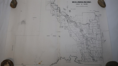
Map - Mullindolingong
... River and beyond.Produced by the Department of Lands and Survey... River and beyond.Produced by the Department of Lands and Survey ...Land owners of land in the Kiewa Valley in 1928The Kiewa Valley was farming country with families settling in the area prior to 1928 Two sheets the same: (one old with paper joined together and the other is a copy without any joins. 21 6 1928 dated Map of Mullindolingong / County of Bogong showing land owners along the Kiewa River and beyond.Produced by the Department of Lands and Survey, Melbournemullindolingong, kiewa valley, land owners, families of the kiewa valley -
Bendigo Historical Society Inc.
Map - LYELL : COUNTY OF BENDIGO, 24-10-84
... School. Photo-Lithographed at the Department of Lands and Survey..., Myrtle Creek. State School. Photo-Lithographed at the Department ...Map. Lyell, County of Bendigo, Eppalock, Sedgwick, Sutton Grange, Hawkestone, Kimbolton, Coliban River, Myrtle Creek. State School. Photo-Lithographed at the Department of Lands and Survey, Melbourne by J. Noune, 24-10-84. (number 71 in map cupboard 1)J. Nounemap, bendigo, lyell -
Bendigo Historical Society Inc.
Map - LYELL : COUNTY OF BENDIGO, 24-9-07
... -Lithographed at the Department of Lands and Survey, Melbourne by T.F... Creek, Coliban River. Photo-Lithographed at the Department ...Map. Lyell, County of Bendigo, Sedgwick, Sutton Grange, Hawkestone, Kimbolton, Eppalock, Myrtle Creek, Coliban River. Photo-Lithographed at the Department of Lands and Survey, Melbourne by T.F. McGauran, 24-9-07, Price 1/-. (number 70 in map cupboard 1)T.F. McGauranmap, bendigo, lyell -
Bendigo Historical Society Inc.
Map - LOCKWOOD : COUNTY OF BENDIGO, 2=7-18
... , Ravenswood, Mandurang. Photo- Lithographed at the Department of Lands..., Mandurang. Photo- Lithographed at the Department of Lands and Survet ...Map. Lockwood, County of Bendigo. Marong, Shelbourne, Ravenswood, Mandurang. Photo- Lithographed at the Department of Lands and Survet, Melbourne by W.J. Butson 2-7-18. By authority A.J. Mullett, Government Printer, Melbourne. Price 1/-. (number 69 in map cupboard 1)A.J. Mullett, Government Printer, Melbourne.map, bendigo, lockwood -
Bendigo Historical Society Inc.
Map - LEICHARDT : COUNTY OF BENDIGO, 15-6-19
... Line. Photo-Lithographed at the Department of Lands and Survey... & Inglewood Railway Line. Photo-Lithographed at the Department ...Map. Leichardt, County of Bendigo, Bridgewater, Yarraberb, Nerring, Marong, Woodstock, Derby, Sandhurst & Inglewood Railway Line. Photo-Lithographed at the Department of Lands and Survey, Melbourne, by T.F. McGauran, 15-6-09. Price 1/-. (number 68 in map cupboard 1)T.F. McGauranmap, bendigo, leichardt -
Bendigo Historical Society Inc.
Map - YARRAYNE : COUNTY OF BENDIGO, 6-1-32
... at the Department of Lands and Survey, Melbourne. Price 2/-. 6-1-32..., Salisbury West, Powlett. Photo-Lithographed at the Department ...Map. Yarrayne, County of Bendigo, Janiember Easr, Pompapiel, Salisbury, Bridgewater, Salisbury West, Powlett. Photo-Lithographed at the Department of Lands and Survey, Melbourne. Price 2/-. 6-1-32.By authority H.J. Green, Govt.Printer. (number 31 in map cupboard 1)H.J. Green, Govt.Printer.map, bendigo, yarrayne -
Bendigo Historical Society Inc.
Map - CORNELLA : COUNTY OF BENDIGO, 18-3-08
... Creek. Photo-Lithographed at the Department of Lands and Survey... at the Department of Lands and Survey, Melbourne by T.F. McGauran. 18-3-08 ...Map. Cornella, County of Bendigo, County of Rodney, Colbinabbin, Gobarup, Redcastle, Toolleen, Cornella Creek, Kangaroo Creek. Photo-Lithographed at the Department of Lands and Survey, Melbourne by T.F. McGauran. 18-3-08. Price 1/-. (number 122 in map cupboard 1)T.F. McGauranmap, bendigo, cornella -
Bendigo Historical Society Inc.
Map - TALAMBE : COUNTY OF BENDIGO, January 1956
... Department of Lands and Survey, Melbourne. January 1956. Price 2..., Pompapiel, Calivil. Drawn and reproduced at trhe Department of Lands ...Map. Talambe, County of Bendigo, Hayanmi, Dingee, Tandarra, Yallook, Pompapiel, Calivil. Drawn and reproduced at trhe Department of Lands and Survey, Melbourne. January 1956. Price 2/-. By authority W.M. Houston, Government Printer, Melbourne. (number 23 in map cupboard 1)W.M. Houston,Government Printer, Melbourne.map, bendigo, talambe -
Bendigo Historical Society Inc.
Map - DERBY : COUNTY OF BENDIGO, 1-9-09
... Railway. Photo-Lithographed at the Department of Lands and Survey... at the Department of Lands and Survey, Melbourne, by T.E. McGauran 1-9-09 ...Map. Derby, County of Bendigo, Inglewood, Loddon River, Tarnagulla, Woodstock, Leichardt, Bridgewater, Bendigo to Inglewood Railway. Photo-Lithographed at the Department of Lands and Survey, Melbourne, by T.E. McGauran 1-9-09. Price 1/-. (number 55 in map cupboard 1)T.E. McGauranmap, bendigo, derby -
Bendigo Historical Society Inc.
Map - HUNTLY : COUNTY OF BENDIGO, August 1954
... and reproduced at the Department of Lands and Survey, Melbourne, Victoria..., Township of Huntly. Drawn and reproduced at the Department of Lands ...Map. Huntly, County of Bendigo. Whirrakee, Bagshot, Wellsford, Nerring, Neilborough, Township of Huntly. Drawn and reproduced at the Department of Lands and Survey, Melbourne, Victoria. August 1954. Price 2/-. By authority W.M. Houston, Government Printer. (number 42 in map cupboard 1)W.M. Houston, Govt. Printer.map, bendigo, huntly -
Bendigo Historical Society Inc.
Map - TALAMBE : COUNTY OF BENDIGO, 17-12-15
... , Yallook, Pompapiel. Photographed at the Department of Lands..., Yallook, Pompapiel. Photographed at the Department of Lands ...Map. Talambe, County of Bendigo, Hayanmi, Dingee, Tandarra, Yallook, Pompapiel. Photographed at the Department of Lands and Survey, Melbourne by W.J. Butson,17-12-15, Price 1/-. Albert J. Mullett, Govt. Printer, Melbourne. (number 17 in map cupboard 1)Albert J. Mullett, Government Printer, Melbourne.map, bendigo, talambe -
Bendigo Historical Society Inc.
Map - PANNOOBAMAWM : COUNTY OF BENDIGO, 1957
... at the Department of Lands and Survey, Melbourne. Price 2/-.1957..., Government Printer, Melbourne. Drawn and reproduced at the Department ...Map. Pannoobamawm, County of Bendigo. By Appointment W.M. Houston, Government Printer, Melbourne. Drawn and reproduced at the Department of Lands and Survey, Melbourne. Price 2/-.1957. Turrumberry, Terrick Terrick East, Wanurp,Pannoomilloo, Bamawm, Pannoobamawm. (number 2 in map cupboard 1)W.M. Houston, Government Printermap, bendigo, pannoobamawm -
Bendigo Historical Society Inc.
Map - NERRING : COUNTY OF BENDIGO, August 1952
... at the Department of Lands and Survey, Melbourne,Victoria. August 1952..., Leichardt, Marong. Drawn and reproduced at the Department of Lands ...Map. Nerring, County Of Bendigo. Yarraberb, Neilborough, Huntly, Sandhurst, Leichardt, Marong. Drawn and reproduced at the Department of Lands and Survey, Melbourne,Victoria. August 1952, Price 2/-. By Appointment J.J. Gourley, Government Printer, Melbourne. (number 0 in map cupboard 1)J.J. Gourley,Government Printermap, bendigo, nerring -
 Bendigo Historical Society Inc.
Map - MARKS COLLECTION: MAP SANDHURST 1867
... for. On bottom of map: 'Lithographed at the Department of Lands... at the Department of Lands and Survey by D. Henderson, 20 February, 1867 ...Original map: Sandhurst 1867, shows central Bendigo and surrounds, including police camp, stockade, 'old cemetery', reserve for. On bottom of map: 'Lithographed at the Department of Lands and Survey by D. Henderson, 20 February, 1867'. On top RH corner 'Sheet No 1 Sandhurst'.map, bendigo, 1867 sandhurst map -
 Kiewa Valley Historical Society
Papers photocopied - photo, list of names, Kiewa Valley Pioneers and Early Activities on the Bogong High Plains
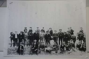
... at Keegans Crossing 2. Department of Crown Lands letter - 1841... the Department of Victorian Lands and Survey re early settlers 3. History... Crossing 2. Department of Crown Lands letter - 1841 Tawonga ...All Early History of the Kiewa Valley. 1. Photo clear but no date. Men named and are residents selecting a site for a bridge at Keegans Crossing 2. Department of Crown Lands letter - 1841 Tawonga pastoral run - Mr James Roberts and Mullindollingong pastoral run 1846 - Mr Patrick Reynolds 3. An account of the Bogong High Plains by W. F. Waters from the late 1890s to 1930s. Published article in the Schuss magazine. August 1958 History of Keegan's Crossing, Kiewa Valley and surrounding residents with names and photos. Early pastoral runs in the Kiewa Valley and Early activities on the Bogong High Plalns..1.The photo includes a listing of residents selecting a site for a bridge at Keegans Crossing. 2. A letter from the Department of Victorian Lands and Survey re early settlers 3. History written in Schuss magaine, Aug. 1958. "In 1896 ... erection of snow poles from Rocky Valley to Tawonga Hut. keegan's crossing, w.f. waters, tawonga and mullindollongong pastoral runs -
 Federation University Historical Collection
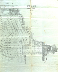
Map, Doroq County of Grenville L4935, 1911, 28 June 1911
... lithographed at the Department of Lands and Survey Melbourne by T. E... at the Department of Lands and Survey Melbourne by T. E. McGauran 28.6.11 ...This plan is associated with former Ballarat School of Mines Student Richard Squire (1875-1876). Gift of the Squire FamilyParish Plan of Doroq in black ink printed on cream paper. It includes the township of Inverleigh and Barwon Rover. Some of the names on the plan are William McRobie, William MacRobie, Thomas Russell, W.C. Smith, John Bell, J. Moffatt, Thomas Moffatt, John Anderson, George Synnot, Charles Lloyd, William MacRobie, J. Flack, Alexander Campell, T. Maher, William Berthon. Thomas Jewell, James Carstairs, D. MCInnerney, F.H. Holland, Robert Morrison17 7/9 18 9 miles handwritten in pencil Photo lithographed at the Department of Lands and Survey Melbourne by T. E. McGauran 28.6.11 Price 1/-carrunge-murnong, murdeduke, carrah, shelford, inverleigh, barwon river, hesse, wingeel, george russell, george russell's pre-emptive section, john moffatt, w. c. smith, macrobie, john bell, thomas russell, t.f. mcgauran -
Bendigo Historical Society Inc.
Map - HEATHCOTE : COUNTY OF BENDIGO, 19-2-1942
... , Government Printer, Melbourne. Drawn and reproduced at the Department... Printer, Melbourne. Drawn and reproduced at the Department ...Map. Heathcote, County of Bendigo. County of Dalhousie, McIvor Creek,Wallan and Bendigo Railway, By authority H.E. Daw, Government Printer, Melbourne. Drawn and reproduced at the Department of Lands and Survey, Melbourne. 19-2-1942. Price 2/-. (number 90 in map cupboard 1)H.E. Daw, Government Printer, Melbourne.map, bendigo, heathcote -
Bendigo Historical Society Inc.
Map - PARISH OF STRATHFIELDSAYE : COUNTY OF BENDIGO, 1-10-19
... -Lithographed at the Department of Lands and Survey, Melbourne... at the Department of Lands and Survey, Melbourne by W.J.Butson, 1-10-19 ...Map. Parish of Strathfieldsaye, County of Bendigo, Wellsford, Sandhurst, Sedgwick, Eppalock, Axedale. Photo-Lithographed at the Department of Lands and Survey, Melbourne by W.J.Butson, 1-10-19. Price 1/-. By authority A.J. Mullett, Government Printer, Melbourne. (number 34 in map cupboard 1)A.J. Mullett, Govt. Printer, Melbourne.map, bendigo, strathfieldsaye -
Bendigo Historical Society Inc.
Map - SEDGWICK : COUNTY OF BENDIGO, 1963
... and reproduced at the Department of Lands and Survey, Melbourne.1963... at the Department of Lands and Survey, Melbourne.1963, Price 2/-. (number 30 ...Map. Sedgwick, County of Bendigo, Strathfieldsaye, Mandurang, Sutton Grange, Lyell, Eppalock County of Talbot Border. By authority A.C. Brooks, Government Printer, Melbourne. Drawn and reproduced at the Department of Lands and Survey, Melbourne.1963, Price 2/-. (number 30 in map cupboard 1)A.C. Brooks, Government Printer, Melbourne.map, bendigo, sedgwick -
Bendigo Historical Society Inc.
Map - SEDGWICK : COUNTY OF BENDIGO, 18-12-20
... at the Department of Lands and Survey, Melbourne by W.j. Butson 18-12-20... Grange, Lyell, Eppalock. Photo-Lithographed at the Department ...Map. Sedgwick, County of Bendigo,Strathfieldsaye, Mandurang, Sutton Grange, Lyell, Eppalock. Photo-Lithographed at the Department of Lands and Survey, Melbourne by W.j. Butson 18-12-20, Price 1/-. By authority A.J.Mullett, Government Printer, Melbourne. (number 29 in map cupboard 1)A.J. Mullett, Government Printer,Me;bourne.map, bendigo, sedgwick -
Bendigo Historical Society Inc.
Map - PANNOOMILLOO : COUNTY OF BENDIGO, 1957
... and reproduced at the Department of Lands and Survey, Melbourne 1957... and reproduced at the Department of Lands and Survey, Melbourne 1957 ...Map. Pannoomilloo, County of Bendigo, Pannoobamawm, Milloo, Diggorra, Warragamba. Elmore Cohuna Railway. Waranga Mallee Channel. By authority W.M. Houston, Government Printer, Melbourne. Drawn and reproduced at the Department of Lands and Survey, Melbourne 1957. Price 2/-. (number 83 in map cupboard 1)W.M. Houston, Government Printer, Melbourne.map, bendigo, pannoomilloo -
Bendigo Historical Society Inc.
Map - NOLAN : COUNTY OF BENDIGO, 7-5-30
... , Government Printer, Melbourne. Drawn and reproduced at the Department... Printer, Melbourne. Drawn and reproduced at the Department ...Map. Nolan, County of Bendigo, Egerton, Elmore, Goornong, Campaspe River, Northern Railway. By Authority H.J. Green, Government Printer, Melbourne. Drawn and reproduced at the Department of Lands and Survey, Melbourne, Victoria.7-5-30. Price 2/-. (number 78 in map cupboard 1)H.J. Green, Government Printer, Melbourne.map, bendigo, nolan