Showing 427 items
matching district roads board
-
 Phillip Island and District Historical Society Inc.
Photograph, 21/11/1969
Photograph donated by Country roads Board.Black & White Photograph showing the Official Opening of the bridge, November 21, 1969. The first Official Car going across.local history, photography, photographs, slides, film, civil engineering, bridges, history of the phillip island bridge, black & white photograph, phillip island bridges -
Phillip Island and District Historical Society Inc.
Publication, November, 1969
Produced and donated by Country Roads Board, 1969. Presented by Bill Papworth.Brochure produced by the Country roads Board for the Official Opening of the new bridge, November 21, 1969.local history, documents, publications, civil engineering, bridges, history of the phillip island bridge, phillip island bridges -
Phillip Island and District Historical Society Inc.
Commemorative Ribbon, 1969
Produced by Country Roads Board for the Opening of the second bridge on November 21 1969. Presented by Bill Papworth.Ribbon inscribed in gold commemorating the Opening of the second bridge and presented in conjunction with brochure described under registration no. 100-15local history, civic mementos, commemorative ribbons, civil engineering, bridges, history of the phillip island bridge, phillip island bridges -
 Phillip Island and District Historical Society Inc.
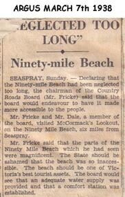
Newspaper clippings, 07/03/1938
Article in which Chairman of Country Roads Board (Mr Fricke) declared that the Ninety Mile Beach had been neglected and should be a Tourist asset. The Board would arrange water supply and Comfort Station.Article about Ninety Mile Beach.local history, documents, newspapers, ninety mile beach, black & white newspaper clipping -
 Greensborough Historical Society
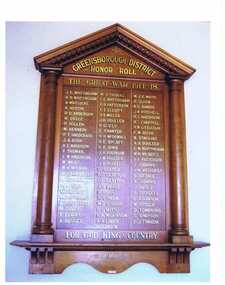
Photograph, Greensborough District Honour Roll, 1914-1918
This photograph of the Greensborough and District Honour Roll was taken on a visit to Greensborough RSL in 2012. [Caption by Bruce McDowell: The name of R H McDowall as shown on the board is incorrectly spelt - it should be R H McDowell - son of William McDowell & Susan Elizabeth McDowell (nee Poulter)]The Honour Board features the names of the Greensborough residents who fought in World War 1 and is located in Greensborough Primary School.A coloured photograph of a Great War 1914 - 1918 Honour Roll. Nilgreensborough, the great war, world war 1, military service -
![Article, Memoirs History 1808 -1883 [extract], 1808-1883](/media/collectors/4f729f5697f83e03086015b8/items/51c8f41e2162ef1ef0b051f7/item-media/51c8fab22162ef1ef0b0592f/item-fit-380x285.jpg) Greensborough Historical Society
Greensborough Historical SocietyArticle, Memoirs History 1808 -1883 [extract], 1808-1883
These pages are an extract from "Memoirs History 1808-1883" pages 345-350. This is John Lindsay Beale's account of the formation of the Greensborough Roads Board and Robert William Whatmough's participation on that Board.The Whatmough and Beale families were pioneers in the Greensborough district. This primary source discusses the difficulties of finding a compromise between those living adjacent to the Plenty River and building and maintaining a roadway between Greensborough and Melbourne.4 pages of typed text. An extract from "Memoirs History 1808 -1883" pages 345 - 350.greensborough roads board, beale, whatmough -
![Article, Greensborough Historical Society et al, Enos John Tinham [Timkem], 1914-1918](/media/collectors/4f729f5697f83e03086015b8/items/59f02f9721ea6909e0c7cb18/item-media/5a963ef921ea730b607bd9e2/item-fit-380x285.jpg) Greensborough Historical Society
Greensborough Historical SocietyArticle, Greensborough Historical Society et al, Enos John Tinham [Timkem], 1914-1918
A short article about Enos John Tinham and his service in World War 1. Enos Tinham also used the name Enos John Timkem; he is remembered on the Greensborough and District Honour Board at the Greensborough RSL as E.J.Timkem.1 page, text and colour images.world war 1 project, enos john tinham, enos john timkem -
 Greensborough Historical Society
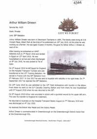
Article, Greensborough Historical Society et al, Arthur William Dineen, 1914-1918
A short article about Arthur William Dineen and his service in World War 1. Arthur William Dineen is commemorated on the Greensborough District Honor Board at the Greensborough RSL.1 Page, text and colour images.world war 1 project, arthur william dineen -
 Greensborough Historical Society
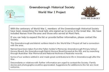
Folder of articles, Greensborough Historical Society et al, World War 1 Project, 1914-1918
With the centenary of World War 1, members of the Greensborough Historical Society researched the local lads who signed up to serve in the Great War. We have included Nurses from the area and those who served at Mont Park. The Greensborough and district soldiers listed in the World War I Project all had a connection with the area. Names have been taken from the Fallen Soldier’s Memorial, Greensborough Primary School Honour Board, the Greensborough District Honour Board housed at the RSL and by searching through Australian War Memorial and National Archives of Australia records. Some of our soldiers settled in and made great contributions to life in Greensborough after the War. Articles are also available on the GHS website. Descendants or relatives with further information are urged to contact the Society. Family stories and photographs would be appreciated. Suggestions for additions to the list are most welcome. Red plastic binder containing over 150 articles, printed text and images. Each article is filed in plastic pocket.world war 1 project, greensborough historical society -
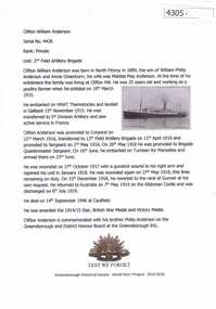 Greensborough Historical Society
Article, Greensborough Historical Society et al, Clifton William Anderson, 1914-1918
A short article about Clifton William Anderson and his service in World War 1. Clifton Anderson is commemorated with his brother Philip Anderson on the Greensborough and District Honour Board at the Greensborough RSL. 1 Page, text and colour images.world war 1 project, clifton william anderson -
 Greensborough Historical Society
Report, Examining Draughtsman's Report - Watts River Aqueduct, 20/07/1897
This Field Survey was commissioned by the Melbourne Board of Works and was used to position the Maroondah Aqueduct bridge north of Greensborough at its crossing point on the Plenty River. It incorporated the use of wrought iron water pipes and therefore is of lighter construction than other similar bridges in the district. It features a traverse of the Plenty RiverThe Maroondah Aqueduct bridge is a significant example of late 19th century engineering. A 4 page reproduction of an Office of Titles document. Copy of handwritten report includes maps.maroondah aqueduct, watts river aqueduct, bridge, greensborough, office of titles, 1897, wrought iron water pipes, plenty river, melbourne board of works -
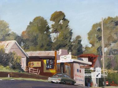 Eltham District Historical Society Inc
Photograph, Ted Dalton, The Corner Store, Ted Dalton, c.1980, 1980c
View of the old Burgoyne store looking south-east across Main Road, Eltham near the intersection with Bridge Street.Digital scan of painting c.1980 oil on board 44.5 x 59.5 cm signed lower rightburgoyne store, eltham, main road, ted dalton -
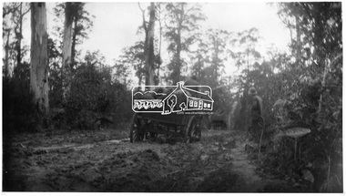 Eltham District Historical Society Inc
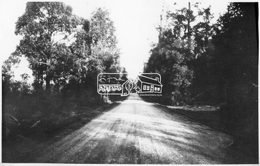
Photograph, Hurstbridge-Kinglake Road, 1 April 1905
Country Roads Board, Neg. No. 18.3This photo forms part of a collection of photographs gathered by the Shire of Eltham for their centenary project book,"Pioneers and Painters: 100 years of the Shire of Eltham" by Alan Marshall (1971). The collection of over 500 images is held in partnership between Eltham District Historical Society and Yarra Plenty Regional Library (Eltham Library) and is now formally known as the 'The Shire of Eltham Pioneers Photograph Collection.' It is significant in being the first community sourced collection representing the places and people of the Shire's first one hundred years.Digital imagesepp, shire of eltham pioneers photograph collection, kinglake, hurstbridge-kinglake road -
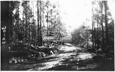 Eltham District Historical Society Inc
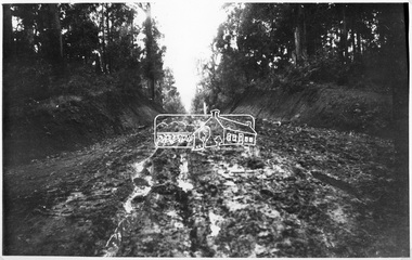
Photograph, Kinglake Road, 13 April 1905
Source: Country Roads Board, Neg. No. 30-23This photo forms part of a collection of photographs gathered by the Shire of Eltham for their centenary project book,"Pioneers and Painters: 100 years of the Shire of Eltham" by Alan Marshall (1971). The collection of over 500 images is held in partnership between Eltham District Historical Society and Yarra Plenty Regional Library (Eltham Library) and is now formally known as the 'The Shire of Eltham Pioneers Photograph Collection.' It is significant in being the first community sourced collection representing the places and people of the Shire's first one hundred years.Digital imagesepp, shire of eltham pioneers photograph collection, kinglake, hurstbridge-kinglake road -
 Eltham District Historical Society Inc
Photograph, Whittlesea-Kinglake Road near "Tommy's Hut", 13 April 1905
Country Roads Board, Neg. No. 30-25This photo forms part of a collection of photographs gathered by the Shire of Eltham for their centenary project book,"Pioneers and Painters: 100 years of the Shire of Eltham" by Alan Marshall (1971). The collection of over 500 images is held in partnership between Eltham District Historical Society and Yarra Plenty Regional Library (Eltham Library) and is now formally known as the 'The Shire of Eltham Pioneers Photograph Collection.' It is significant in being the first community sourced collection representing the places and people of the Shire's first one hundred years.Digital imagesepp, shire of eltham pioneers photograph collection, kinglake, whittlesea-kinglake road -
 Eltham District Historical Society Inc
Photograph, Kinglake Road
Country Roads Board, Neg. No. 30-24This photo forms part of a collection of photographs gathered by the Shire of Eltham for their centenary project book,"Pioneers and Painters: 100 years of the Shire of Eltham" by Alan Marshall (1971). The collection of over 500 images is held in partnership between Eltham District Historical Society and Yarra Plenty Regional Library (Eltham Library) and is now formally known as the 'The Shire of Eltham Pioneers Photograph Collection.' It is significant in being the first community sourced collection representing the places and people of the Shire's first one hundred years.Digital imagesepp, shire of eltham pioneers photograph collection, kinglake, kinglake road -
 Eltham District Historical Society Inc
Photograph, Liz Pidgeon, Heritage Excursion; Eltham Lower Park Walk and Talk, 1 July 2017, 1 July 2017
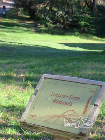
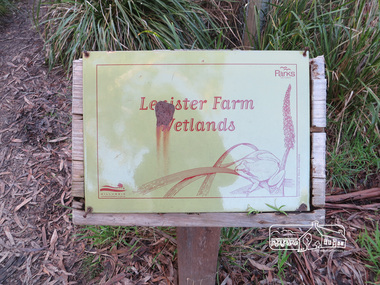
Information Board - Lenister Farm Wetlands Newsletter No., 234, June 2017 Heritage Excursion - Saturday 1st July - Eltham Lower Park - Walk and Talk Eltham Lower Park has played an important part in the history of our area since the early days of European settlement when it was used by local residents as an informal racecourse. Prior to that its location at the junction of the Diamond Creek and the Yarra River made it an important meeting place for the Wurundjeri people. The park combines formal elements and sporting facilities with remnant bushland that is of environmental significance. It is home to sporting and horse riding clubs, popular play spaces and the Diamond Valley Miniature Railway, which attracts large numbers of visitors. The park will be the venue for our July excursion which will comprise a walk of about 3.5 km around the park and adjacent areas. Along the way we will discuss the history and natural history of the area. The path along the creek and the river provides a pleasant and scenic walk. This walk on Saturday 1st July is about 3.5 km in length and will take 2 to 2.5 hours. It will start at 2pm at the Main Road car park at the front of the park. (Melway ref 21 H 10). Born Digitalheritage excursion, activities, eltham district historical society, eltham lower park, information board, lenister farm -
 Eltham District Historical Society Inc
Photograph, Liz Pidgeon, Heritage Excursion; Eltham Lower Park Walk and Talk, 1 July 2017, 1 July 2017
Faded Information Board - Wetland Wildlife situated in Lenister Wetlands Newsletter No., 234, June 2017 Heritage Excursion - Saturday 1st July - Eltham Lower Park - Walk and Talk Eltham Lower Park has played an important part in the history of our area since the early days of European settlement when it was used by local residents as an informal racecourse. Prior to that its location at the junction of the Diamond Creek and the Yarra River made it an important meeting place for the Wurundjeri people. The park combines formal elements and sporting facilities with remnant bushland that is of environmental significance. It is home to sporting and horse riding clubs, popular play spaces and the Diamond Valley Miniature Railway, which attracts large numbers of visitors. The park will be the venue for our July excursion which will comprise a walk of about 3.5 km around the park and adjacent areas. Along the way we will discuss the history and natural history of the area. The path along the creek and the river provides a pleasant and scenic walk. This walk on Saturday 1st July is about 3.5 km in length and will take 2 to 2.5 hours. It will start at 2pm at the Main Road car park at the front of the park. (Melway ref 21 H 10). Born Digitalheritage excursion, activities, eltham district historical society, eltham lower park, information board -
 Eltham District Historical Society Inc
Photograph, Liz Pidgeon, Heritage Excursion; Eltham Lower Park Walk and Talk, 1 July 2017, 1 July 2017
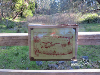
Information Board : Not just a pretty place Newsletter No., 234, June 2017 Heritage Excursion - Saturday 1st July - Eltham Lower Park - Walk and Talk Eltham Lower Park has played an important part in the history of our area since the early days of European settlement when it was used by local residents as an informal racecourse. Prior to that its location at the junction of the Diamond Creek and the Yarra River made it an important meeting place for the Wurundjeri people. The park combines formal elements and sporting facilities with remnant bushland that is of environmental significance. It is home to sporting and horse riding clubs, popular play spaces and the Diamond Valley Miniature Railway, which attracts large numbers of visitors. The park will be the venue for our July excursion which will comprise a walk of about 3.5 km around the park and adjacent areas. Along the way we will discuss the history and natural history of the area. The path along the creek and the river provides a pleasant and scenic walk. This walk on Saturday 1st July is about 3.5 km in length and will take 2 to 2.5 hours. It will start at 2pm at the Main Road car park at the front of the park. (Melway ref 21 H 10). Born Digitalelection day, heritage excursion, activities, eltham district historical society, eltham lower park, information board -
 Eltham District Historical Society Inc
Photograph, Liz Pidgeon, Heritage Excursion; Eltham Lower Park Walk and Talk, 1 July 2017, 1 July 2017
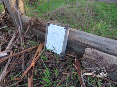
Information Board with rust - Lenister Farm Wetlands Newsletter No., 234, June 2017 Heritage Excursion - Saturday 1st July - Eltham Lower Park - Walk and Talk Eltham Lower Park has played an important part in the history of our area since the early days of European settlement when it was used by local residents as an informal racecourse. Prior to that its location at the junction of the Diamond Creek and the Yarra River made it an important meeting place for the Wurundjeri people. The park combines formal elements and sporting facilities with remnant bushland that is of environmental significance. It is home to sporting and horse riding clubs, popular play spaces and the Diamond Valley Miniature Railway, which attracts large numbers of visitors. The park will be the venue for our July excursion which will comprise a walk of about 3.5 km around the park and adjacent areas. Along the way we will discuss the history and natural history of the area. The path along the creek and the river provides a pleasant and scenic walk. This walk on Saturday 1st July is about 3.5 km in length and will take 2 to 2.5 hours. It will start at 2pm at the Main Road car park at the front of the park. (Melway ref 21 H 10). Born Digitalelection day, heritage excursion, activities, eltham district historical society, eltham lower park, information board, lenister farm wetlands -
 Eltham District Historical Society Inc
Photograph, Liz Pidgeon, Heritage Excursion; Eltham Lower Park Walk and Talk, 1 July 2017, 1 July 2017
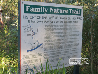
Information Board titled: Family Nature Trail - History of the land of Lower Eltham Park Newsletter No., 234, June 2017 Heritage Excursion - Saturday 1st July - Eltham Lower Park - Walk and Talk Eltham Lower Park has played an important part in the history of our area since the early days of European settlement when it was used by local residents as an informal racecourse. Prior to that its location at the junction of the Diamond Creek and the Yarra River made it an important meeting place for the Wurundjeri people. The park combines formal elements and sporting facilities with remnant bushland that is of environmental significance. It is home to sporting and horse riding clubs, popular play spaces and the Diamond Valley Miniature Railway, which attracts large numbers of visitors. The park will be the venue for our July excursion which will comprise a walk of about 3.5 km around the park and adjacent areas. Along the way we will discuss the history and natural history of the area. The path along the creek and the river provides a pleasant and scenic walk. This walk on Saturday 1st July is about 3.5 km in length and will take 2 to 2.5 hours. It will start at 2pm at the Main Road car park at the front of the park. (Melway ref 21 H 10). Born Digitalheritage excursion, activities, eltham district historical society, eltham lower park, information board, trail -
 Eltham District Historical Society Inc
Photograph, Liz Pidgeon, Heritage Excursion; Eltham Lower Park Walk and Talk, 1 July 2017, 1 July 2017
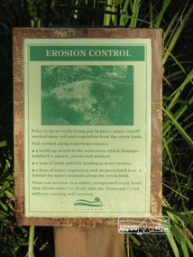
Information board titled "erosion control" including a photo and causes produced by the Shire of Nillumbik Newsletter No., 234, June 2017 Heritage Excursion - Saturday 1st July - Eltham Lower Park - Walk and Talk Eltham Lower Park has played an important part in the history of our area since the early days of European settlement when it was used by local residents as an informal racecourse. Prior to that its location at the junction of the Diamond Creek and the Yarra River made it an important meeting place for the Wurundjeri people. The park combines formal elements and sporting facilities with remnant bushland that is of environmental significance. It is home to sporting and horse riding clubs, popular play spaces and the Diamond Valley Miniature Railway, which attracts large numbers of visitors. The park will be the venue for our July excursion which will comprise a walk of about 3.5 km around the park and adjacent areas. Along the way we will discuss the history and natural history of the area. The path along the creek and the river provides a pleasant and scenic walk. This walk on Saturday 1st July is about 3.5 km in length and will take 2 to 2.5 hours. It will start at 2pm at the Main Road car park at the front of the park. (Melway ref 21 H 10). Born Digitalheritage excursion, activities, eltham district historical society, eltham lower park, erosion, information board -
 Eltham District Historical Society Inc
Photograph, Liz Pidgeon, Heritage Excursion; Eltham Lower Park Walk and Talk, 1 July 2017, 1 July 2017
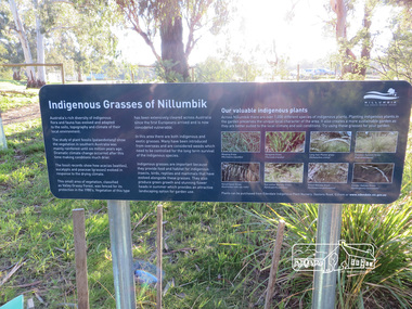
Plaque explaining "Indigenous grasses of Nillumbik" from the Shire of Nillumbik Newsletter No., 234, June 2017 Heritage Excursion - Saturday 1st July - Eltham Lower Park - Walk and Talk Eltham Lower Park has played an important part in the history of our area since the early days of European settlement when it was used by local residents as an informal racecourse. Prior to that its location at the junction of the Diamond Creek and the Yarra River made it an important meeting place for the Wurundjeri people. The park combines formal elements and sporting facilities with remnant bushland that is of environmental significance. It is home to sporting and horse riding clubs, popular play spaces and the Diamond Valley Miniature Railway, which attracts large numbers of visitors. The park will be the venue for our July excursion which will comprise a walk of about 3.5 km around the park and adjacent areas. Along the way we will discuss the history and natural history of the area. The path along the creek and the river provides a pleasant and scenic walk. This walk on Saturday 1st July is about 3.5 km in length and will take 2 to 2.5 hours. It will start at 2pm at the Main Road car park at the front of the park. (Melway ref 21 H 10). Born Digitalheritage excursion, activities, eltham district historical society, eltham lower park, information board, indigenous grass, indigenous plants -
 Eltham District Historical Society Inc
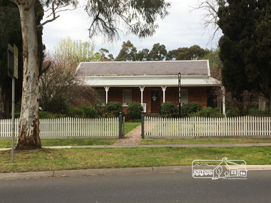
Photograph, Peter Pidgeon, Wingrove Cottage 1858 home of C.S Wingrove, Secretary Eltham Roads Board 1857 & Shire of Eltham 1871, 2 Sep 2017
Heritage Excursion - An Eltham South Ramble, 2 Sep 2017Born Digitalactivities, eltham district historical society, eltham south, heritage excursion, local history centre -
 Eltham District Historical Society Inc
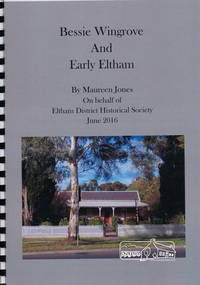
Book, Maureen Jones, Bessie Wingrove and Early Eltham by Maureen Jones, 2016
Bessie Wingrove (1870-1955) was born in Eltham, one of ten children born to Charles Wingrove, former Secretary of the Eltham Roads Board. Much of the publication describes the Wingrove family. Bessie attended University and graduated as a teacher, she travelled and returned to live in Eltham. Includes endnotes and Family Group Record for Charles Symons Wingrove and his wife Katherine Nodin. See also EDHS Newsletter Number 223 July 2015 for article on Bessie Wingrove by Maureen Jones This book is significant in that not only does it document broadly the history of Charles Wingrove a key person in the early history of Eltham but also his family, and specifically his daughter Bessie, ensuring that women's stories are added to the early male dominated and documented history of the area. It also gives an insight into the people and wider Eltham community.Spiral bound. 15 p. includes photographsbessie wingrove, wingrove family, eltham -
 Eltham District Historical Society Inc
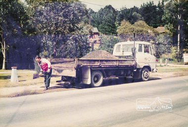
Photograph, Road Maintenance
One of a set of display images thought to be produced by the Shire of Eltham c.1979-1987. Council worker filling a pot hole on the side of a road with gravel from the back of a truck. There is a fire hydrant close by. Exact street location unknown.Illustrative of services provided by former Shire of ElthamColour photograph 20 x 29 cm mounted on green-painted chipboard 28 x 35.5 cm (string on back for hanging)Title printed on label adhered to board below photograph (replaced June 2017)road maintenance -
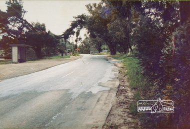 Eltham District Historical Society Inc
Photograph, Eltham-Yarra Glen Road, Reynolds Road to Kanandah Court
One of a set of display images thought to be produced by the Shire of Eltham c.1979-1987Illustrative of services provided by former Shire of ElthamColour photograph 20 x 29 cm mounted on green-painted chipboard 28 x 35.5 cm (string on back for hanging)Title printed on label adhered to board below photograph (replaced June 2017)road, eltham -
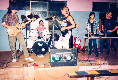 Eltham District Historical Society Inc
Photograph, Local band rehearsing at Youth Centre
One of a set of display images thought to be produced by the Shire of Eltham c.1979-1987. Youth band performing on stage at the Youth Centre, Youth Road, Eltham. The Hall is now home to the 1st Eltham Scout Group. It also hosts the annual Paddy's Market organised by the Eltham Rural Group.Illustrative of services provided by former Shire of ElthamColour photograph 20 x 29 cm mounted on green-painted chipboard 28 x 35.5 cm (string on back for hanging)Title printed on label adhered to board below photograph (replaced June 2017)youth band, youth centre -
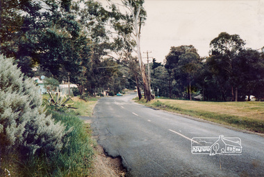 Eltham District Historical Society Inc
Photograph, Eltham-Yarra Glen Road, Reynolds Road to Kanandah Court
One of a set of display images thought to be produced by the Shire of Eltham c.1979-1987Illustrative of services provided by former Shire of ElthamColour photograph 20 x 29 cm mounted on green-painted chipboard 28 x 35.5 cm (string on back for hanging)Title printed on label adhered to board below photograph (replaced June 2017)road, eltham-yarra glen road, eltham -
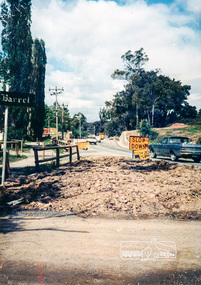 Eltham District Historical Society Inc
Photograph, Looking east along Main Rd towards Research at intersection to entrance for Eltham Barrel (now Kalbar Rd) C.1980
One of a set of display images thought to be produced by the Shire of Eltham c.1979-1987Illustrative of services provided by former Shire of ElthamColour photograph 20 x 29 cm mounted on green-painted chipboard 28 x 35.5 cm (string on back for hanging)Title printed on label adhered to board below photograph (replaced June 2017)eltham, main road, eltham, road, eltham barrel