Showing 319 items matching "dredging"
-
 Lakes Entrance Historical Society
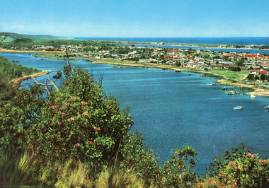
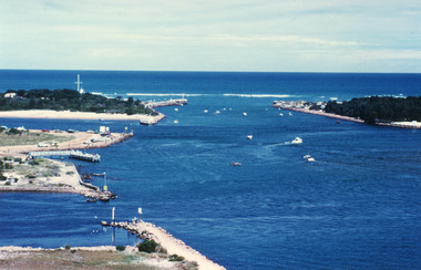
Postcard - Lakes Entrance, Engelander John & Co Pty Ltd, 1980c
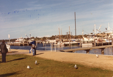
Panoramic view of Lakes Entrance taken by Melbourne firm for West Germany A.F.K. International Publishers of world's most famous beauty spotsColour postcard with serrated edge, of the township, situated between Cunninghame Arm and North Arm. Boats moored at jetties and beside boat ramps in North Arm. Photo taken from Kalimna Heights. Dredged sand dumped in North Arm bight. Lakes Entrance VictoriaLakes Entrance, Victoria, Australia (on back) waterways, topography, township -
 Lakes Entrance Historical Society
Photograph - Lakeside, Holding George, 1984c
Part of a series of seven colour photographs taken from same spot on the same dayColor photographs showing progress of extension to lakeside at the West boat Harbour, taken from the car park, showing many moored vessels. In the foreground the sand dredged from other areas and dumped in order to extend the car park and lakeside walkways. Lakes Entrance Victoriawaterfront, boats and boating -
 Lakes Entrance Historical Society
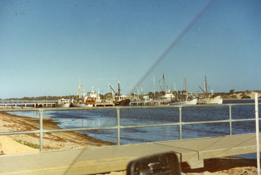
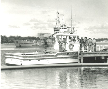
Photograph, Lakes Post Newspaper, Gippsland Ports vessel Latrobe Lakes Entrance Victoria, 1/11/1995 12:00:00 AM
Black and white photograph of Gippsland Ports vessel Latrobe and crew taken on training day for Oil Spill disaster. Dredge April Hamer in background both moored at Bullock Island Lakes Entrance Victoria. Also photograph taken during Oil Spill disaster activities gippsland ports, events -
 Lakes Entrance Historical Society
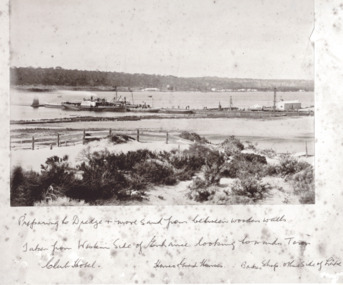
Photograph - New Works Jetty, Brooks Photographic Union, 1885 cm
Written under photograph ' Preparing to dredge and move sand from between wooden walls. Taken from Western side of Entrance looking towards Town Club Hotel, Homes Guest House Bakers shop other side of LakesBlack and white photograph of boat loads of tourists moored at New Works Jetty during the construction of the man made entrance at Lakes Entrance Victoriapublic works, jetties, tourism -
 Lakes Entrance Historical Society
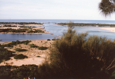
Photograph - The Entrance, Fraser Ian, 1995c
Colour photograph of the entrance from Bass Strait to the Gippsland Lakes. It shows the western end of Bullock Island and the entrance to North Arm, cars parked on island and many people fishing. This area built up during dredging operations over many years. Lakes Entrance Victoria topography, fishing industry, boats and boating -
 Lakes Entrance Historical Society
Photograph - Bullock Island, 1990c
Black and white photograph of the entrance. It shows two fishing boats moored in North Arm, western end of Bullock Island with Fishermens Co-op building, and area below Jemmys Point, both formed during dredging operations over many years. Lakes Entrance Victoria waterfront, islands -
 Lakes Entrance Historical Society
Photograph - Lakes Entrance, 2000
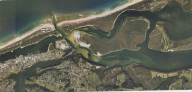
Colour photograph aerial view of the entrance, shows entry to North Arm, Cunninghame Arm, Bullock Island, part of Rigby Island, new North Arm Bridge in place, Club Hotel still in situ, small dredge working south west corner of Bullock Island. Lakes Entrance Victoriaislands, waterways, hotels, bridges -
 Stawell Historical Society Inc
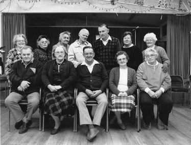
Photograph, Senior Citizens Club Office Bearers in the Clubrooms 1991-1992
Group inside Senior Citizens Clubrooms. Back row Daphne Beckwith, Nellie Blake, Myrtle Pyke, Cec Dredge, Stan Raeburn, Florence Unthank, Ella Holloway. Front Row John Street, Nat Raeburn, Jim Bigmore, Nellie Howen Bonnie Dean. Black & white photograph of group of people inside a hall. One row seated the other standing behind the seated row.stawell -
 Glenelg Shire Council Cultural Collection
Photograph - Photograph - Main Breakwater construction, Portland, n.d
Port of Portland Authority Archives -
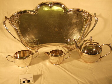 Bright & District Historical Society operating the Bright Museum
Teaset silver
Mr.and Mrs Don Jessup and Mr.and Mrs.Ted Jessup presented the teaset to the then President of the Bright and District Historical Society, Mrs. Gwyneth Millar. The trophy was won by their uncle, Charles Jessup, in 1909 for cycling at the Bright Easter Sports Meeting.00053.1 Silver tray with ornate handles and holly decoration. 00053.2 Teapot. Spherical shape with attached lid. 00053.3 Two handled sugar bowl. 00053.4 Milk jug 00053.1 Presented by the, Tewksberry \ Amal. Gold Dredging Co. \ to the \ Bright \ Easter Sports Club \ Won by \ G. Jessup \ Easter 1909 00053.2 Lily E.P.N.S. A1 00053.3 Imperial A1 E.P.N.S. Hand soldered. 14 00053.4 26 A1 Imperial E.P.N.S. Hand soldered silver, teaset, jug, teapot, sugar bowl, tray, tewksberry gold dredging, jessup, sports, easter, cycling -
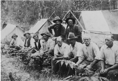 Halls Gap & Grampians Historical Society
Photograph - Sepia, C 1909
Grampians halls Gap at Stoney Creek Dredge. The site of the Stoney Creek diggings was in the upper catchment area of the creek, beside Silverband Road. For further information see: 'Bridging the Gap' by Ida Stanton, p. 49 and 'Victoria's Wonderland' by Halls Gap and Grampians Historical Society, p. 41.Photo shows eight men seated, two standing, 3 tents in background. 2nd right Alfred D'Alton 4th Right James Oliverwater supplies, d'alton, water supplies, channels -
Hume City Civic Collection
Container - Bottle - Wine, Digger's Rest Vineyard Pinot Noir 1994
This wine bottle was donated by Frank and Judy Hogan for use in the exhibition 'A History of Vineyards in Sunbury' held at the George Evans Museum in 1996. The Digger's Rest Vineyard was planted in 1987. With the help of winemaker Peter Dredge in 1994 the Digger's Rest vineyard was awarded two medals at the Victorian Wine Show.Conventional green glass wine bottle with indented base. A gold, purple, white and black printed label on the front with a drawing of a gold digger on a log. a printed label. A printed label is on the back. There is a small foil label around top of neck of bottle. a gold and black stick on label with 1994 on the lower RH corner.front label: Digger's Rest/VINEYARD/PINOT NOIR/Old Vineyard Road, Sunbury 3429...digger's rest vineyard, wines, bottles, frank and judy hogan, 1980s, 1990s, george evans collection -
Glenelg Shire Council Cultural Collection
Photograph - Contact Prints - Harbour Construction, n.d
Port of Portland Authority Archivesport of portland archives -
 Lakes Entrance Historical Society
Photograph - The Entrance, 1995c
Second colour copy as 01601-1 portrait size 15 x 10Colour photograph of the entrance from Bass Strait to the Gippsland Lakes. It shows buildings on Bullock Island including Peck's factory. Western end of Bullock Island and area below Jemmys Point, both made during dredging operations over many years. Two fishing boats in entrance. Lakes Entrance Victoria room display, waterways, topography -
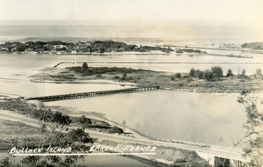 Lakes Entrance Historical Society
Postcard - Bullock Island, Bulmer H D, 1945
Black and white postcard of Bullock Island, Lakes Entrance, showing an extensive rock groyne to the south of the island, into which dredged sand and spoil is to be placed in order to extend the island's area. North Arm bridge, Bullock Island footbridge, New Works settlement and Entrance channel also in image. Lakes Entrance VictoriaBullock Island, Lakes Entranceboats and boating, fishing industry, islands -
 Lakes Entrance Historical Society
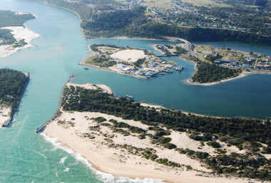
Photograph - Lakes Entrance, Gippsland Ports, 2006 c
... Dredging ...Colour aerial photograph showing view of entrance to Gippsland Lakes from Bass Strait Reeves Channel Rigby Island and township of Lakes Entrance Victoriaaerial photograph, historic site, dredging, waterways, lakes entrance -
 Tarnagulla History Archive
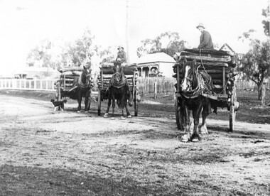
Photograph of three wagons loaded with logs, Three wagons loaded with logs, early 20th Century (original image)
Murray Comrie Collection. Monochrome photograph depicting three wagons loaded with logs, being driven by three unidentified men. The photograph appears to be taken in Gladstone Street, Tarnagulla. The wagons are carting five-foot firewood billets to the Tarnagulla Gold Estates hydraulic dredge operation.. This photograph is a fair copy of an older original, probably made in the late 1960s. tarnagulla, timber, haulage, transport, horses, wagons, industry, people -
Port Melbourne Historical & Preservation Society
Plan - Proposed docks and straight cut canal, Port Melbourne, Proposed Harbour Accommodation, 23 Sep 1902
Large plan of proposed docks and straight cut canal, reserve, proposed Harbour Accommodation - Port Melbourne. (Brown with age/or dirt) Shows enormous landfill into Hobson's Bay and around Town and Railway Piers; branch railway lines. Includes dredging plans and two narrow docks at Melbourne - also garden reserve and suburb of Fishermen's Bend.melbourne harbor trust - port of melbourne authority, town planning - proposals shelved, fishermans bend -
Port Melbourne Historical & Preservation Society
Audio - PMHPS Meeting, History of the Port of Melbourne, Dr Judith Buckrich, Glen Stuart, 27 Aug 2001
Recording of PMHPS Meeting on 27.08.2001. Recording done by Glen Stuart at Port Town Hall. Speaker was Dr Judith Buckrich on the history of the Port of Melbourne ; early exploration of Port Phillip; settlement; difficulties establishing Melbourne Harbor Trust; Coode Canal; dredging problems particularly with ever larger vessels. Recording duration 52:05transport - shipping, melbourne harbor trust - port of melbourne authority, judith raphael buckrich -
 Lakes Entrance Historical Society
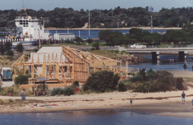
Photograph - Fishing Club Lakes Entrance Victoria, LE Tidy Town Committee, 1994
Fishing Club building under construction Bullock Island bridge in background April Hamer moored Lakes Entrance Victoria. Another colour photograph of Gippland Lakes Fishing Club under construction in background dredged sand behind building boat ramp in foreground number 04057.1 size 10 x 15 cmColour photograph of Fishing Club building under construction Bullock Island bridge in background April Hamer moored Lakes Entrance Victoria recreation, fishing, buildings, clubs -
 Lakes Entrance Historical Society
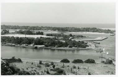
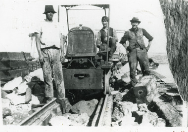
Photograph - New Works, 1925c
Also another copy 13 x 20cm, good conditionBlack and white photograph of three men working on original wooden piers at the entrance to Bass Strait. Rail tractor built by J A Day and Son especially for New Works project, powered by dredge car engine, pulled three rail trucks loaded with rocks to reinforce original wooden piers. Three men not identified. Lakes Entrance Victoria public works, construction -
 Lakes Entrance Historical Society
Photograph - Lena Bird, Soderlund Olav, 1985
Date April 1985Color photograph of an arm of the boat harbour and the Western Wharf, known coloquially as the Post Office Jetty. It shows fishing boats private vessels and the tourist launch Lenna Bird moored at the jetties. In the foreground the recently dumped dredged sand has been compacted behind a retaining wall to form a new pathway beside the lake. Lakes Entrance Victoriaroads and streets, waterfront, boats and boating -
Glen Eira Historical Society
Article - Hengar, Glen Eira Road, 356, Elsternwick
Two original copies and one photocopy of a one page article from The Age, 07/03/1990, by Rhonda Dredge, advertising the auction of Hengar. The article describes the architectural features of the Victorian style building, its original use as a dower house and gives a brief history of its occupancy. The article includes a black and white photograph of the exterior of Hengar.hengar, rosecraddock, happy days childminding centre, glen eira road, elsternwick, caulfield, architectural styles, federation style, victorian style, house auctions, preschools, langdon family, dredge rhonda, buxton j r -
 Federation University Historical Collection
Book, Hydraulic and Placer Mining, 1898, 1905
... dredging ...Blue/black hard covered book of 234 pages including index and photographic reproductions. Contents include Uses of Water in Mining; Geology of Placer Deposits; Gold Recovery; Flumes, ditches, dams, pipes; Giants, valaves, gates, weirs, miner's inch, pressure box, dams; gravel elvators; exploiting. mining, hydraulics, water, dredge, dredging, gold mining -
 Federation University Historical Collection
Photograph, Gold Dredge
... dredging ...Black and white mounted photograph of a dedge floating on a body of water which has a creek flowing into it, and rolling hills in the background. The buildings associated with a mine or factory are shown on the top left hand side. Signed "Martin ?ish Victoria St" verso "R.H. Brooke, "Callantina Villa", Glenferrie Rd Sthdredge, dredging, mining, river, callantina villa, gold mining -
 Linton and District Historical Society Inc
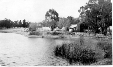
Photograph, Dredge hut, Granny's Paddock
... Dredging ...Black and white photograph of a hut located beside a dam of water.dams, mines, dredging, buildings, huts, granny's paddock -
 Lakes Entrance Historical Society
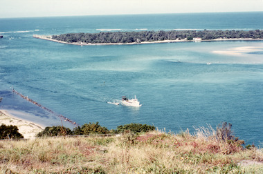
Photograph - The Entrance, Fraser, Ian, 1990c
Colour photograph of the lake. It shows a fishing boat with scallop dredge moving up the lake opposite the artificial entrance, grassy edge of Jemmy's Point in foreground above highway guard fence, rock groyne at entry to North Arm, sandy shallows at entry to Hopetoun Channel, scrub covered hummocks of south shore and Bass Strait in distance. Lakes Entrance Victoriaislands, waterways, topography -
 Flagstaff Hill Maritime Museum and Village
Document - Navigation Chart, Admiralty Office, Lady Bay and Warrnambool Harbour, 1893
This navigation cart of Lady Bay and Warrnambool Harbour was originally surveyed in 1870 but this version includes the update for magnetic variation in 1893. Since the printing of the chart several annotations have been added. These include an additional stamp dated 15-8-1910, a handwritten comment across the top of the page dated August 1910, and another handwritten comment regarding the ‘Proposed Extension of Dock’ dated 19-2-1925, plus connected drawings, notes and figures. The 1925 proposal on this chart may have been a reaction to the Royal Commission of 1923, when the damaged stonework on the seaward side of the Warrnambool Breakwater, caused by the action of the sea, was the subject of enquiry. A conference between the Public Works, Water Commission and the Harbour Trust concluded that it would less costly to make repairs to prevent further damage rather than replaced the damage portion of the wall. A contract was raised in late 1924 to deposit rubble on the damaged side of the breakwater to minimise the Southern Ocean’s destructive action and work had started by August 1925. The Breakwater construction had begun in 1874 and was completed in 1890. The Victorian Government had commissioned Sir John Coode, a British harbour engineer, to present a plan to complete the Warrnambool Breakwater but his original plan was too expensive. He prepared a revised plan for a shorter structure. The construction proved to be too short to protect adequately from the weather and didn't allow enough depth for larger vessels to come into port. The decreasing trade was further affected by siltation in the bay due to the breakwater, and the completion of the railway line. The situation of the harbour became a real problem by 1910 and required continuous dredging. In 1914 the Breakwater was extended but proved to be a failure because the work began to subside and by 1920 about two thirds of the harbour was silted up. Alterations made in the 1920's increased the silting problem and by the 1940's the harbour was no longer used. More alterations were made in the 1950's and 1960's. This chart is significant for its strong connection to the maritime history of Warrnambool Harbour and Lady Bay and the Warrnambool Breakwater. The Warrnambool Breakwater is registered as a place of significance on the Victorian Heritage Database (VHR H2024). The Warrnambool Breakwater is one of the most important late 19th century maritime engineering projects in Victoria and significant in the development of Victorian coastal shipping. It is also significant for its connection with British harbour engineer, Sir John Coode. The chart is a historical record of structures existing in 1893; the Warrnambool Jetties, Warrnambool Breakwater in Lady Bay, the leading lights (lighthouses), streets, roads, bridges and many buildings. It also shows the lay of the land and seabed. Navigation Chart: Lady Bay and Warrnambool Harbour, Australia - South Coast - Victoria. Surveyed by Nav. Lieut. H.J. Stanley, R.N., 1870. Updated for Magnetic Variation, 1893. The rectangular chart is printed on heavy cream paper. Stamps are shaped rectangular, oval and round. Around the Breakwater and Jetty area are handwritten notes, dotted and joined lines, numbers and signatures, and shading of red and green. The chart shows the surrounds of Warrnambool Harbour, Lady Bay, the Breakwater and Jetty, roads, bridges and the streets in Warrnambool. It has sounding details, and angles of line from the leading lights.Stamp, rectangular, including "AUG 1910" Stamp, double oval " - - - -CHART" Stamp, hand drawn, red circle, with "B" inside Hand written note "22-8-1910 - - - - - of surveying C. Ca - - - request of 15-8-10 [initials] " Notes and lines in red pen, including a grid of sounding numbers: "1300" "1050" "1200" "Possible Extension of Dock" "19-2-25" "Dock Dredged to 20 Ft" Notes and lines in blue pen "Extension of Dock to accommodate vessels drawing 20 Feet" and "Light not visible south of this line" Red dots (4) with yellow highlight at both leading lights, breakwater and jettyflagstaff hill, warrnambool, flagstaff hill maritime museum & village, maritime museum, maritime village, shipwreck coast, map, chart, navigation chart, plan, lady bay, warrnambool harbour, port of warrnambool, breakwater, jetty, pier, dock extension, proposed extension, vhr h2024, 1870, 1893, 1910, 1925, warrnambool town late 1800s, warrnambool streets late 1800s royal commission, 1923, public works, water commission, harbour trust, victorian harbours, sir jon coode -
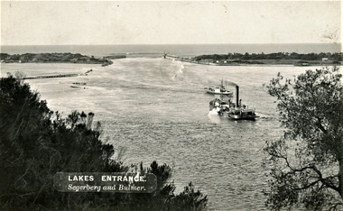 Lakes Entrance Historical Society
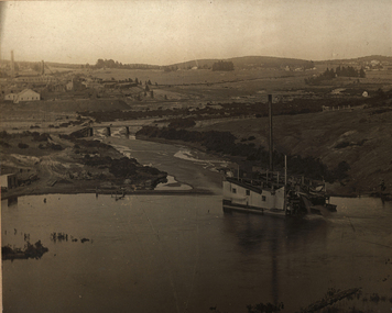
Photograph - The Entrance, Segerberg and Bulmer, 1910 c
Also enlargement 17 x 23 cmBlack and white photograph showing view from Jemmys Point of the entrance to the Gippsland Lakes from Bass Strait. Pioneer dredge in centre foreground, and steamer JCD. Cottages and works buildings including Rocket shed on eastern dunes, Schnapper Cottage on far right western dune. Rock groynes and tip of Bullock Island centre left. Vegetation in foreground. Lakes Entrance VictoriaLAKES ENTRANCE Segerberg and Bulmerships and shipping, topography, jetties, houses -
Federation University Historical Collection
Booklet, G.S. Hart, Ballarat School of Mines Student's Magazine, First Term, 1904, 1904
Table of contents: Editorial, The analysis of water for technical purposes, Standard and other solutions, Bucket dredging in Ballarat and its vicinity, A visit to Dapto, Life in British Guiana, Deep alluvial mining, The S.M.B. camp, In the magazines, Practical experience for mining engineers, Balance sheet students' magazine for the year ending 1903, Past students', Our illustrations, Diplomas and Certificates, Sports, Meeting of student association, New students', News and notes, Editorial notices.Pale gray booklet of 19 pagesballarat school of mines, students' magazine, j. t. d'oliveyra, j. r. mckenzie, j. dickenson, h. kingsbury, f. bicknell,, a. bendallack, l. westcott, a. gibson, g. s. hart, j. brangan, v. barton, w. a. gabriel, a. turner, a. woods, f. futter, v. vicol, h. w. blyth, f. m. lush, s. b. vial, l. nash, p. f. d. elliott, a. s. burdekin, w. playford, s. j. lindsay, lloyd petersham, j. wallis, johnstone, j. mcfeeters, d. w. b. arthur, f. fryer, h. giles, a. s. coyte, f. malin, j. m. currie, d. thomas, k. moore, w. edwards, h. alston, w. white, n. fraser, s. adamson,, w. brokenshire, w. f. brinsden, h. edgar, j. hil, h. leggo, p. e. marmion, j. don, f. cooper, f. dalton, c. eeles, r. elliott, e. trend, h. dowling,, d. elder, r. ford, a. paramour, a. gillespie, a. walters, w. bolte, h. burrows, p. v. barnard, l. lambert, w. j. lakeland, a. mcburney, j. ramsay, b. reid, f. a. marriott, s. radcliff, america, o. e. jager, p. a. millar, m. gray, r. j. allan, f. f. bradbury, w. a. gosman, a. g. s. morton, m. marks, t. vincent, j. vincent, r. nevett, d. urquhart, south africa, r. suter, h. l. krause, c. bailey, a. c. atkins, g. s. hart, e. j. a. mcconnon, o. e. jager, j. t. philbin, w. j. lakeland, l. w. nott, o. w. williams, f. r. williams, c. h. magennis, w. e. dempster, w, featherstone, j. smart, g. h. davenport, alan cropper, w. e. eyres, j. w. pearce, a. j. robin, a. c. leathes, w. o. avery, g. sides, c. milligan,, g. elliott, l. w. seward, e. r. gaunt, w. macartney, n. buley, s. r. white, r. king, c. s. stephenson, alfred mica smith, g. j. dawbarn, r. w. hawken, kerr gran, professor ferdinand krause, w. atherton, j. w. hawthorne, p. a. millar, f. a. marriott, f. c. futter., g. w. cornell, j. adam, h. w. nevett, v. g. anderson, c. mctaggart, d. don, w. tucker, h. eklund, kildhal