Showing 904 items matching "eltham east"
-
 Eltham District Historical Society Inc
Photograph, Beard Street, Eltham, 3 Sep 1981
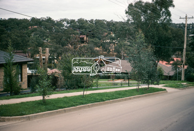
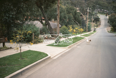
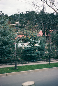
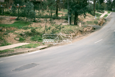
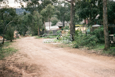
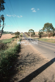
... of roads and houses in the Eltham East area, 3 September 1981 prior... of roads and houses in the Eltham East area, 3 September 1981 prior ...Roll of film taken by Eltham Shire Council officers of roads and houses in the Eltham East area, 3 September 1981 prior to construction of new water main; including views of existing damage to footpaths and gutters and general views of Beard Street. These images provide a perspective of housing estate developments and changes in housing styles and road development which began sweeping in from the mid 1970s with increasing urbanisation of what was once more outlying suburbs and regions.35mm colour positive transparency (1 of 28) Mount - Kodak Kodachrome Cardeltham, infrastructure, roads, beard street, frank street -
 Eltham District Historical Society Inc
Photograph, Beard Street, Eltham, 3 Sep 1981
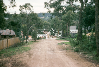
... of roads and houses in the Eltham East area, 3 September 1981 prior... of roads and houses in the Eltham East area, 3 September 1981 prior ...Roll of film taken by Eltham Shire Council officers of roads and houses in the Eltham East area, 3 September 1981 prior to construction of new water main; including views of existing damage to footpaths and gutters and general views of Beard Street. These images provide a perspective of housing estate developments and changes in housing styles and road development which began sweeping in from the mid 1970s with increasing urbanisation of what was once more outlying suburbs and regions.35mm colour positive transparency (1 of 28) Mount - Kodak Kodachrome Cardeltham, infrastructure, roads, beard street, grove street, valonia drive, wycliffe crescent, livingstone road -
 Eltham District Historical Society Inc
Photograph, Beard Street, Eltham, 3 Sep 1981
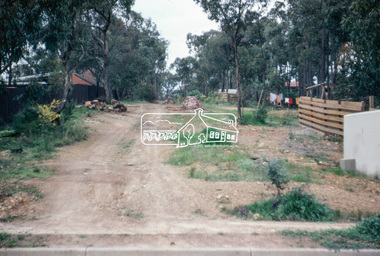
... of roads and houses in the Eltham East area, 3 September 1981 prior... of roads and houses in the Eltham East area, 3 September 1981 prior ...Roll of film taken by Eltham Shire Council officers of roads and houses in the Eltham East area, 3 September 1981 prior to construction of new water main; including views of existing damage to footpaths and gutters and general views of Beard Street. These images provide a perspective of housing estate developments and changes in housing styles and road development which began sweeping in from the mid 1970s with increasing urbanisation of what was once more outlying suburbs and regions.35mm colour positive transparency (1 of 28) Mount - Kodak Kodachrome Cardeltham, infrastructure, roads, beard street -
 Eltham District Historical Society Inc
Photograph, Beard Street, Eltham, 3 Sep 1981
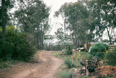
... of roads and houses in the Eltham East area, 3 September 1981 prior... of roads and houses in the Eltham East area, 3 September 1981 prior ...Roll of film taken by Eltham Shire Council officers of roads and houses in the Eltham East area, 3 September 1981 prior to construction of new water main; including views of existing damage to footpaths and gutters and general views of Beard Street. These images provide a perspective of housing estate developments and changes in housing styles and road development which began sweeping in from the mid 1970s with increasing urbanisation of what was once more outlying suburbs and regions.35mm colour positive transparency (1 of 28) Mount - Kodak Kodachrome Cardeltham, infrastructure, roads, beard street -
 Eltham District Historical Society Inc
Photograph, Water Main Pipe Track (Madine Way-Bainbridge Drive), Eltham, 3 Sep 1981
... of roads and houses in the Eltham East area, 3 September 1981 prior... of roads and houses in the Eltham East area, 3 September 1981 prior ...Roll of film taken by Eltham Shire Council officers of roads and houses in the Eltham East area, 3 September 1981 prior to construction of new water main; including views of existing damage to footpaths and gutters and general views of Beard Street. These images provide a perspective of housing estate developments and changes in housing styles and road development which began sweeping in from the mid 1970s with increasing urbanisation of what was once more outlying suburbs and regions.35mm colour positive transparency (1 of 28) Mount - Kodak Kodachrome Cardeltham, infrastructure, roads, bainbridge drive linear reserve, madine way, water main pipe track -
 Eltham District Historical Society Inc
Photograph, Water Main Pipe Track (Madine Way-Eucalyptus Road), Eltham, 3 Sep 1981
... of roads and houses in the Eltham East area, 3 September 1981 prior... of roads and houses in the Eltham East area, 3 September 1981 prior ...Roll of film taken by Eltham Shire Council officers of roads and houses in the Eltham East area, 3 September 1981 prior to construction of new water main; including views of existing damage to footpaths and gutters and general views of Beard Street. These images provide a perspective of housing estate developments and changes in housing styles and road development which began sweeping in from the mid 1970s with increasing urbanisation of what was once more outlying suburbs and regions.35mm colour positive transparency (1 of 28) Mount - Kodak Kodachrome Cardeltham, infrastructure, roads, water main pipe track, madine way, eucalyptus road, tadema park -
 Eltham District Historical Society Inc
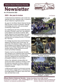
Journal - Newsletter, Newsletter, No. 273 December 2023
... in WW2 by Terry Beaton • 60 Years Ago at Eltham East Primary... in WW2 by Terry Beaton • 60 Years Ago at Eltham East Primary ...Contents: • 2023 – the year in review by Jim Connor • Our Next Meeting - 7.30pm Wednesday 13th December 2023 • Eltham Mudbrick House Tour • Tim Burstall – Pioneer Film Maker by Marguerite Marshall • The Prize: Marcys Skipper’s comments • Threats to Kangaroo Ground by Richard Pinn • Local Mother’s Incredible Support in WW2 by Terry Beaton • 60 Years Ago at Eltham East Primary by Stephen Corneille • Community banking – our local story by Malcom Hackett OAM The Shire of Eltham Historical Society was formed in October 1967. The first newsletter of the Society was issued May 1978 and has been published continuously ever since on a bi-monthly basis. With the cessation of the Shire of Eltham in late 1994, the Society's name was revised to Eltham District Historical Society and this name first appeared with issue No. 103, July 1995. The collection of the Society's newsletters provides a valuable resource on the history of the Society's activities, office bearers and committee members, guest speakers and subjects of historical interest pertinent to the former Shire of Eltham and the Eltham District.A4 newsletter distributed to members (Digital and A4 photocopy)newsletter, eltham district historical society -
 Eltham District Historical Society Inc
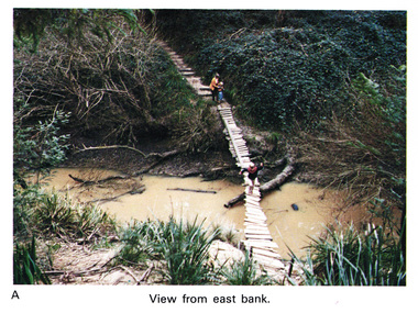
Work on paper (Sub-Item) - Photograph, Home-made footbridge across Diamond Creek, opposite Gum Glade, Eltham
... the Diamond Creek opposite Gum Glade, Eltham. View from east bank.... the Diamond Creek opposite Gum Glade, Eltham. View from east bank ...Colour photograph of home-made footbridge across the Diamond Creek opposite Gum Glade, Eltham. View from east bank.eltham, diamond creek, footbridge, gum glade -
 Eltham District Historical Society Inc
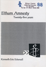
Book, Eltham amnesty : twenty-five years / Kenneth Eric Eckersall, 2002
... The Eltham Branch (North East Metro Group) of Amnesty... melbourne The Eltham Branch (North East Metro Group) of Amnesty ...The Eltham Branch (North East Metro Group) of Amnesty International was formed in 1977. This booklet documents its first 25 years.Paperback; iv, 27 p. ; 21 cm.amnesty international (eltham group), political prisoners -
 Eltham District Historical Society Inc
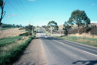
Slide - Photograph, Eltham-Yarra Glen Road, Kangaroo Ground, c.May 1988
... Looking east along Eltham-Yarra Glen Road, Kangaroo Ground... melbourne Looking east along Eltham-Yarra Glen Road, Kangaroo Ground ...Looking east along Eltham-Yarra Glen Road, Kangaroo Ground, c.May 198835mm colour positive transparency (1 of 36) Mount - Kodak KodachromeProcess Date MAY 88Minfrastructure, roads, eltham-yarra glen road, kangaroo ground -
 Eltham District Historical Society Inc
Journal - Newsletter, Newsletter, No. 272 October 2023
... Historical Society 50th Anniversary by Liz Pidgeon • Eltham East... Historical Society 50th Anniversary by Liz Pidgeon • Eltham East ...Contents: • Vale - Sue Law - 27th September 1937 - 8th August 2023 • Our Next Meeting - 7.30pm Wednesday 11th October 2023 • Heritage Excursion - Saturday 4th November 2023 - Eltham Gateway Walk • Eltham Films by Richard Pinn • Serendipity In Eltham by Terry Beaton • Alan Marshall by Jim Connor • Nillumbik Historical Society 50th Anniversary by Liz Pidgeon • Eltham East Primary School 60th Anniversary • The MEN behind the Names – Eltham Roll of Honour Board (Part 2) by Terry Beaton • Local History Centre Room Names • Eltham Cemetery Stories by Liz Pidgeon o Beatrice Wanliss Morrison, nee Irvine, 1899-1989, Naturalist and Community volunteer • Experience Eltham Cemetery by Julia Drew The Shire of Eltham Historical Society was formed in October 1967. The first newsletter of the Society was issued May 1978 and has been published continuously ever since on a bi-monthly basis. With the cessation of the Shire of Eltham in late 1994, the Society's name was revised to Eltham District Historical Society and this name first appeared with issue No. 103, July 1995. The collection of the Society's newsletters provides a valuable resource on the history of the Society's activities, office bearers and committee members, guest speakers and subjects of historical interest pertinent to the former Shire of Eltham and the Eltham District.A4 newsletter distributed to members (Digital and A4 photocopy)newsletter, eltham district historical society -
 Eltham District Historical Society Inc
Photograph, Peter Pidgeon, View from Bolton Street, Eltham, 2 Aug. 2022
... of Eltham View looking east from Bolton Street near Brougham Street... of Eltham View looking east from Bolton Street near Brougham Street ...View looking east from Bolton Street near Brougham Street, Eltham taken from PETStock looking over the industrial area of Eltham View looking east from Bolton Street near Brougham Street, ElthamBorn Digitaleltham, bolton steet, industry, petstock eltham central, little eltham -
 Eltham District Historical Society Inc
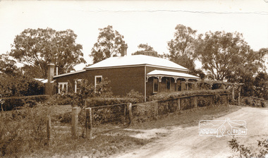
Photograph, Peter Bassett-Smith, 22 York Street, Eltham, c.1933, 1933c
... ), Eltham from the north east. Formerly home of Bassett-Smith family...Eltham District Historical Society Inc 728 Main Rd Eltham ...Two sepia photographs of 22 York Street (renumbered 28), Eltham from the north east. Formerly home of Bassett-Smith family c.1933 Original house of 4 rooms, Skillion added c.y W.B. Bassett-Smith FRIBA, Enwright, builder, Ivanhoeyork street, eltham, houses, peter bassett smith -
 Eltham District Historical Society Inc
Photograph - Aerial Photograph, Landata, Research, Vic, Apr. 1963
... Road to south, Eltham College to east and Eltham Gateway Hotel... Road to south, Eltham College to east and Eltham Gateway Hotel ...Centred on present day Thompson Crescent and Nicholson Close, Research bounded by Maroondah Aqueduct to north, Nyora Road to south, Eltham College to east and Eltham Gateway Hotel to west. Historic Aerial Imagery Source: Landata.vic.gov.au Aerial Photo Details: Project No :486 Project : MELBOURNE (1963) PROJECT Run : 5 Frame : 61 Date : 04/1963 Film Type : B/W Camera : RC8 Flying Height : 5100 Scale : 9600 Film Number : 1805 GDA2020 : 37°42'24"S, 145°10'06"E MGA2020 : 338528, 5825143 (55) Melways : 22 D3 (ed. 42)aerial photo, neil webster collection, eltham, 1963-04, eltham college, eltham gateway hotel and conference centre, maroondah aqueduct, melway 22d3, nicholson close, nyora road, research (vic.), thompson crescent -
 Eltham District Historical Society Inc
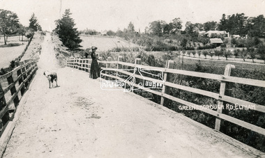
Photograph, Bridge over the Diamond Creek, Greensborough Road, Eltham, c.1885
... Original (1874) bridge in Bridge Street, Eltham looking...Eltham District Historical Society Inc 728 Main Rd Eltham ...Original (1874) bridge in Bridge Street, Eltham looking east over the Diamond Creek towards Maria Street (Main Road) at Little Eltham. In the distance to the right on Maria Street is the Methodist Church (1881), now Uniting Church, and the adjacent Commercial Bank of Australia branch building (1878). Part of a slide show presentation "Bridges & Waterways of the Shire" by Russell Yeoman to the 13 September 1989 Society meeting. The presentation included slides of historic photos from the Shire of Eltham Pioneers collections as well as several recent views.Photo of original 1875 timber and gravel surface bridge over the Diamon Creek in Bridge Street with views of orchards representative of the farming lands as well as the development along the northern end of Maria Street.Black and white photograph copybridge street, bridge street bridge, cba bank, diamond creek (creek), eltham, little eltham, main road, maria street, methodist church, uniting church -
 Eltham District Historical Society Inc
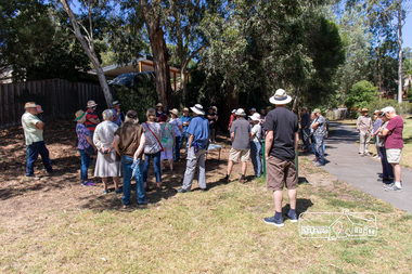
Photograph, Peter Pidgeon, Heritage Excursion: Woodridge Wander, 6 March 2021
... to Woodridge Linear Park in Grove Street just east of the Eltham East... to Woodridge Linear Park in Grove Street just east of the Eltham East ...The Woodridge Estate was a major residential subdivision that was developed in many stages in the 1970s and 80s. It extended easterly from the older residential area of Eltham into what had previously been largely privately owned bushland. The subdivision design took into account the steep topography and resulted in large blocks that enabled preservation of much of the tree cover. It included a number of small parks and walkways and the one kilometre long Woodridge Linear Park. A bushland area left as a proposed school site later became the Pauline Toner Butterfly Reserve for preservation of the rare Eltham Copper Butterfly. This walk explores some Woodridge streets as well as the linear park and butterfly reserve, a hilly walk of about 3 km and includes some moderately rough tracks. Permission to visit the external grounds of two private properties to view heritage listed houses not visible from the street was granted. The walk commenced at 2pm at the access to Woodridge Linear Park in Grove Street just east of the Eltham East Primary School (Melway ref 22 B4). This free walk was open to the general public as well as Society members. Whilst COVID restrictions did not require the wearing of masks in the open, masks had to be carried and all attendees registered with name and contct number.Born Digital (41 images)covid-19, eltham, eltham district historical society, heritage excursion, woodridge estate -
 Eltham District Historical Society Inc
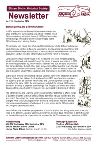
Newsletter, Newsletter, No. 218 September 2014
... Meeting • September Excursion - East of Eltham Walk • Have you... Meeting • September Excursion - East of Eltham Walk • Have you ...Contents: • Eltham Living and Learning Centre • September Meeting • September Excursion - East of Eltham Walk • Have you discovered Trove? by Liz Pidgeon • Fabbro Farm Art Project • Eltham Library - 20th Anniversary Celebration • Henry Gilbert Jones: an early Eltham settler........and an amazing coincidence by Michael Aitken • Street by Street The Shire of Eltham Historical Society was formed in October 1967. The first newsletter of the Society was issued May 1978 and has been published continuously ever since on a bi-monthly basis. With the cessation of the Shire of Eltham in late 1994, the Society's name was revised to Eltham District Historical Society and this name first appeared with issue No. 103, July 1995. The collection of the Society's newsletters provides a valuable resource on the history of the Society's activities, office bearers and committee members, guest speakers and subjects of historical interest pertinent to the former Shire of Eltham and the Eltham District.A4 photocopied newsletter distributed to membersnewsletter, eltham district historical society, shire of eltham historical society -
 Eltham District Historical Society Inc
Photograph - Aerial Photograph, Landata, Research, Vic, Apr. 1972
... by Allendale Road to north, Thompson Crescent to south, Eltham College...Eltham District Historical Society Inc 728 Main Rd Eltham ...Centred on present day Maroong Drive, Research bounded by Allendale Road to north, Thompson Crescent to south, Eltham College to east and Parsons Road to west. Historic Aerial Imagery Source: Landata.vic.gov.au Aerial Photo Details: Project No :985 Project : MELBOURNE 1972 Run : 26 Frame : 193 Date : 04/1972 Film Type : B/W Camera : RC10 Flying Height : 5700 Scale : 9600 Film Number : 2636 GDA2020 : 37°42'04"S, 145°10'33"E MGA2020 : 339187, 5825794 (55) Melways : 22 F1 (ed. 42)aerial photo, neil webster collection, 1972-04, allendale road, eltham, eltham barrel, eltham college, maroong drive, melway 22f1, parsons road, research (vic.), thompson crescent -
 Eltham District Historical Society Inc
Photograph - Aerial Photograph, Landata, Eltham / Research, Vic, Jan. 1951
... to south, Eltham College to east and Leane Drive to west... to south, Eltham College to east and Leane Drive to west ...Centred on Brinkkotter Road opposite Yarramie Reserve, Eltham bounded by Maroondah Aqueduct to north, Nyora Road to south, Eltham College to east and Leane Drive to west. Historic Aerial Imagery Source: Landata.vic.gov.au Aerial Photo Details: Project No :65 Project : MELBOURNE AND METROPOLITAN PROJECT NO. 2 Run : 7 Frame : 8 Date : 01/1951 Film Type : B/W Camera : EAG9 Flying Height : 12200 Scale : 12000 Film Number : 1419 GDA2020 : 37°42'32"S, 145°10'41"E MGA2020 : 339408, 5824924 (55) Melways : 22 F3 (ed. 42)Historical aerial photos and photo maps provide viusal evidence of the chronology of changes to the built landscape of the district and assist in dating other imagesaerial photo, 1951-01, eltham, neil webster collection, brinkkotter road, eltham college, leane drive, maroondah aqueduct, melways 22f3, nyora road, yarramie reserve -
 Eltham District Historical Society Inc
Photograph - Aerial Photograph, Landata, Eltham North, Feb. 1956
... Centred on present day 54 Kelway Crescent, Eltham North...Eltham District Historical Society Inc 728 Main Rd Eltham ...Centred on present day 54 Kelway Crescent, Eltham North bounded by Glen Gully Road to north, Meruka Drive to south, Eltham College to east and Leach Street to west. Historic Aerial Imagery Source: Landata.vic.gov.au Aerial Photo Details: Project No :250 Project : MELBOURNE OUTER SUBURBS PROJECT Run : 17 Frame : 113 Date : 02/1956 Film Type : B/W Camera : EAG9 Flying Height : 10000 Scale : 12000 Film Number : 1176 GDA2020 : 37°42'16"S, 145°08'08"E MGA2020 : 335650, 5825336 (55) Melways : 21 G2 (ed. 42)aerial photo, 1956-02, eltham, eltham north, glen gully road, leach street, main road, melway 21g2, meruka drive, montmorency, neil webster collection -
 Eltham District Historical Society Inc
Photograph - Aerial Photograph, Landata, Research, Vic, Apr. 1963
... Drive to east and Eltham Research Oval to west. Historic Aerial... Drive to east and Eltham Research Oval to west. Historic Aerial ...Centred on present day Marconi Court, Research bounded by Maroondah Aqueduct to north, Thompson Crescent to south, Joselyn Drive to east and Eltham Research Oval to west. Historic Aerial Imagery Source: Landata.vic.gov.au Aerial Photo Details: Project No :486 Project : MELBOURNE (1963) PROJECT Run : 5 Frame : 62 Date : 04/1963 Film Type : B/W Camera : RC8 Flying Height : 5100 Scale : 9600 Film Number : 1805 GDA2020 : 37°42'24"S, 145°10'43"E MGA2020 : 339434, 5825157 (55) Melways : 22 F3 (ed. 42)aerial photo, neil webster collection, 1963-04, joselyn drive, marconi court, melway 22f3, research (vic.), research oval, thompson crescent