Showing 224 items
matching engineering officer
-
 Kew Historical Society Inc
Plan, Melbourne & Metropolitan Board of Works : Borough of Kew : Detail Plan No.1571, 1904
... by the contractor, but more likely by officers working in the Engineering... by the contractor, but more likely by officers working in the Engineering ...The Melbourne and Metropolitan Board of Works (MMBW) plans were produced from the 1890s to the 1950s. They were crucial to the design and development of Melbourne's sewerage and drainage system. The plans, at a scale of 40 feet to 1 inch (1:480), provide a detailed historical record of Melbourne streetscapes and environmental features. Each plan covers one or two street blocks (roughly six streets), showing details of buildings, including garden layouts and ownership boundaries, and features such as laneways, drains, bridges, parks, municipal boundaries and other prominent landmarks as they existed at the time each plan was produced. (Source: State Library of Victoria)This plan forms part of a large group of MMBW plans and maps that was donated to the Society by the Mr Poulter, City Engineer of the City of Kew in 1989. Within this collection, thirty-five hand-coloured plans, backed with linen, are of statewide significance as they include annotations that provide details of construction materials used in buildings in the first decade of the 20th century as well as additional information about land ownership and usage. The copies in the Public Record Office Victoria and the State Library of Victoria are monochrome versions which do not denote building materials so that the maps in this collection are invaluable and unique tools for researchers and heritage consultants. A number of the plans are not held in the collection of the State Library of Victoria so they have the additional attribute of rarity.Digital copy of the original survey plan, issued by the MMBW to a contractor with responsibility for constructing sewers in the area identified on the plan within the Borough of Kew. The plan was at some stage hand-coloured, possibly by the contractor, but more likely by officers working in the Engineering Department of the Borough and later Town, then City of Kew. The hand-coloured sections of buildings on the plan were used to denote masonry or brick constructions (pink), weatherboard constructions (yellow), and public buildings (grey). This plan is part of a large and historically significant group of MMBW plans and maps that was donated to the Society by the Mr Poulter, City Engineer of the City of Kew in 1989. When the contracts were let for surveyors to identify and record the extant houses and landscapes within an area for the Board of Works, the contracts were let at separate times, hence the anomaly where two copies of Plan No.1571 exist in our collection. The first of these plans identifies the building materials used in houses bordering Fitzwilliam Street, Edgevale Road, May Street, Malin Street, Davis Street and Wellington Street. The cut off point for the survey was the south side of Wellington Street. By 1903 when the survey was undertaken many of the sites were already built on, particularly those facing Edgevale Road. The plan identifies the preponderance of weatherboard houses in the area. The other version of the plan identifies the buildings between Wellington Street and Cotham Road.melbourne and metropolitan board of works, detail plans, mmbw 1571, cartography -
 Kew Historical Society Inc
Plan, Melbourne & Metropolitan Board of Works : Borough of Kew : Detail Plan No.1571, 1904
... -coloured, possibly by the contractor, but more likely by officers... likely by officers working in the Engineering Department ...The Melbourne and Metropolitan Board of Works (MMBW) plans were produced from the 1890s to the 1950s. They were crucial to the design and development of Melbourne's sewerage and drainage system. The plans, at a scale of 40 feet to 1 inch (1:480), provide a detailed historical record of Melbourne streetscapes and environmental features. Each plan covers one or two street blocks (roughly six streets), showing details of buildings, including garden layouts and ownership boundaries, and features such as laneways, drains, bridges, parks, municipal boundaries and other prominent landmarks as they existed at the time each plan was produced. (Source: State Library of Victoria)This plan forms part of a large group of MMBW plans and maps that was donated to the Society by the Mr Poulter, City Engineer of the City of Kew in 1989. Within this collection, thirty-five hand-coloured plans, backed with linen, are of statewide significance as they include annotations that provide details of construction materials used in buildings in the first decade of the 20th century as well as additional information about land ownership and usage. The copies in the Public Record Office Victoria and the State Library of Victoria are monochrome versions which do not denote building materials so that the maps in this collection are invaluable and unique tools for researchers and heritage consultants. A number of the plans are not held in the collection of the State Library of Victoria so they have the additional attribute of rarity.Original survey plan, issued by the MMBW to a contractor with responsibility for constructing sewers in the area identified on the plan within the Borough of Kew. The plan was at some stage hand-coloured, possibly by the contractor, but more likely by officers working in the Engineering Department of the Borough and later Town, then City of Kew. The hand-coloured sections of buildings on the plan were used to denote masonry or brick constructions (pink), weatherboard constructions (yellow), and public buildings (grey). This plan is the other half of Plan No.1571 representing the constructions to the west of Wellington Street before and in 1903/4. This plan represents the built environment in Edgevale Road, Wellington Street, Atkins Street, Annadale Street, Mortimer Street, and Cotham Road. Whereas there are smaller allotments and more modest housing stock facing Edgevale Road, larger blocks and more substantial houses are represented facing Cotham Road.melbourne and metropolitan board of works, detail plans, mmbw 1571, cartography -
 Kew Historical Society Inc
Plan, Melbourne & Metropolitan Board of Works : Borough of Kew : Detail Plan No.1572, 1905
... -coloured, possibly by the contractor, but more likely by officers... likely by officers working in the Engineering Department ...The Melbourne and Metropolitan Board of Works (MMBW) plans were produced from the 1890s to the 1950s. They were crucial to the design and development of Melbourne's sewerage and drainage system. The plans, at a scale of 40 feet to 1 inch (1:480), provide a detailed historical record of Melbourne streetscapes and environmental features. Each plan covers one or two street blocks (roughly six streets), showing details of buildings, including garden layouts and ownership boundaries, and features such as laneways, drains, bridges, parks, municipal boundaries and other prominent landmarks as they existed at the time each plan was produced. (Source: State Library of Victoria)This plan forms part of a large group of MMBW plans and maps that was donated to the Society by the Mr Poulter, City Engineer of the City of Kew in 1989. Within this collection, thirty-five hand-coloured plans, backed with linen, are of statewide significance as they include annotations that provide details of construction materials used in buildings in the first decade of the 20th century as well as additional information about land ownership and usage. The copies in the Public Record Office Victoria and the State Library of Victoria are monochrome versions which do not denote building materials so that the maps in this collection are invaluable and unique tools for researchers and heritage consultants. A number of the plans are not held in the collection of the State Library of Victoria so they have the additional attribute of rarity.Original survey plan, issued by the MMBW to a contractor with responsibility for constructing sewers in the area identified on the plan within the Borough of Kew. The plan was at some stage hand-coloured, possibly by the contractor, but more likely by officers working in the Engineering Department of the Borough and later Town, then City of Kew. The hand-coloured sections of buildings on the plan were used to denote masonry or brick constructions (pink), weatherboard constructions (yellow), and public buildings (grey). Plan No. 1572 represents the built environment bordered by Barkers Road, Wrixon Street, Edgevale Road and Fitzwilliam Street. Other streets identified on the plan include Stansell Street. Plan 1572 shows that by 1903-05, there was only patchy development in this area of Kew, mainly on Edgevale Road and Fitzwilliam Street. Only two named houses are identified: the quaintly named ‘Tweed Cottage’, and ‘Mendip’. The earliest reference to Treed Cottage in Australian newspapers is to the death of Walter Thompson, aged 74 who was a resident there in 1885. His youngest daughter was to die there in 1908. Mendip to the north of Tweed Cottage was owned by Henry Thompson; he was to die in 1901; his wife in 1932. At this period of time, Malin Street and Clivedon Court did not extend to Barkers Road.melbourne and metropolitan board of works, detail plans, mmbw 1572, cartography -
 Kew Historical Society Inc
Plan, Melbourne & Metropolitan Board of Works : Borough of Kew : Detail Plan No.1573, 1905
... -coloured, possibly by the contractor, but more likely by officers... by the contractor, but more likely by officers working in the Engineering ...The Melbourne and Metropolitan Board of Works (MMBW) plans were produced from the 1890s to the 1950s. They were crucial to the design and development of Melbourne's sewerage and drainage system. The plans, at a scale of 40 feet to 1 inch (1:480), provide a detailed historical record of Melbourne streetscapes and environmental features. Each plan covers one or two street blocks (roughly six streets), showing details of buildings, including garden layouts and ownership boundaries, and features such as laneways, drains, bridges, parks, municipal boundaries and other prominent landmarks as they existed at the time each plan was produced. (Source: State Library of Victoria)This plan forms part of a large group of MMBW plans and maps that was donated to the Society by the Mr Poulter, City Engineer of the City of Kew in 1989. Within this collection, thirty-five hand-coloured plans, backed with linen, are of statewide significance as they include annotations that provide details of construction materials used in buildings in the first decade of the 20th century as well as additional information about land ownership and usage. The copies in the Public Record Office Victoria and the State Library of Victoria are monochrome versions which do not denote building materials so that the maps in this collection are invaluable and unique tools for researchers and heritage consultants. A number of the plans are not held in the collection of the State Library of Victoria so they have the additional attribute of rarity.Original survey plan, issued by the MMBW to a contractor with responsibility for constructing sewers in the area identified on the plan within the Borough of Kew. The plan was at some stage hand-coloured, possibly by the contractor, but more likely by officers working in the Engineering Department of the Borough and later Town, then City of Kew. The hand-coloured sections of buildings on the plan were used to denote masonry or brick constructions (pink), weatherboard constructions (yellow), and public buildings (grey). This plan has detailed annotations written in red or blue ink, showing prices, which may be the annual valuations of the properties, and some owners’ names, a most unusual feature on contractor's maps. Some areas, such as the buildings of Methodist Ladies’ College (MLC), include the school’s tennis court and swimming pool, but are not coloured to show building materials – did the draftsman just run out of time, or ink, or enthusiasm, before his plan had to be submitted? MLC had been founded in 1882 as a ‘modern school of the first order’ with buildings that formed ‘a collegiate institution for girls unsurpassed in the colonies’. The goal of its founders was to provide a high-class Christian education for girls, comparable with that provided elsewhere for boys. Some shops are shown along Edgevale Road, though they are not designated as commercial premises. Larger houses are depicted, including ‘Fairlawn’ in Barkers Road, and ‘Clevedon’ and ‘Rosehill’ (now demolished) in Fitzwilliam Street.melbourne and metropolitan board of works, detail plans, mmbw 1573, maps - borough of kew, cartography -
 Kew Historical Society Inc
Plan, Melbourne & Metropolitan Board of Works : Borough of Kew : Detail Plan No.1574, 1905
... -coloured, possibly by the contractor, but more likely by officers... by the contractor, but more likely by officers working in the Engineering ...The Melbourne and Metropolitan Board of Works (MMBW) plans were produced from the 1890s to the 1950s. They were crucial to the design and development of Melbourne's sewerage and drainage system. The plans, at a scale of 40 feet to 1 inch (1:480), provide a detailed historical record of Melbourne streetscapes and environmental features. Each plan covers one or two street blocks (roughly six streets), showing details of buildings, including garden layouts and ownership boundaries, and features such as laneways, drains, bridges, parks, municipal boundaries and other prominent landmarks as they existed at the time each plan was produced. (Source: State Library of Victoria)This plan forms part of a large group of MMBW plans and maps that was donated to the Society by the Mr Poulter, City Engineer of the City of Kew in 1989. Within this collection, thirty-five hand-coloured plans, backed with linen, are of statewide significance as they include annotations that provide details of construction materials used in buildings in the first decade of the 20th century as well as additional information about land ownership and usage. The copies in the Public Record Office Victoria and the State Library of Victoria are monochrome versions which do not denote building materials so that the maps in this collection are invaluable and unique tools for researchers and heritage consultants. A number of the plans are not held in the collection of the State Library of Victoria so they have the additional attribute of rarity.Original survey plan, issued by the MMBW to a contractor with responsibility for constructing sewers in the area identified on the plan within the Borough of Kew. The plan was at some stage hand-coloured, possibly by the contractor, but more likely by officers working in the Engineering Department of the Borough and later Town, then City of Kew. The hand-coloured sections of buildings on the plan were used to denote masonry or brick constructions (pink), weatherboard constructions (yellow), and public buildings (grey). This plan shows several very large houses, particularly along Glenferrie Road, and the area now occupied by Ruyton Girls’ School. ‘Tarring’ (incorrectly spelled here as ‘Karring’) was built for Henry Henty in 1872, on part of his original allotment of 20 acres, and ‘Mount View’, which retains its original building and the fountain in the front garden, is part of Ruyton’s Junior School. The most significant change to Tarring and its grounds since 1903, involve the removal of a number of the outbuildings, including a Burmese temple, bought by Henty from the Burmese Exhibit at the Great Exhibition of 1880. It is shown on the plan as a summerhouse. The two-storey mansion, on the corner of Glenferrie Road and Wellington Street, was built in 1891 by leading architect Alfred White as his own home. Having an initial N.A.V. of £160, the house was purchased by a warehouseman Henry Lister, by 1900, when the N.A.V. was recorded at £111. By the turn of the century the house was known as ‘Comaques’. By contrast, much smaller houses are shown in Scott and Byron Streets, including a tiny Mission Hall in Byron Street, which belonged to the Anglican Church from at least 1903 to 1917.melbourne and metropolitan board of works, detail plans, maps - borough of kew, mmbw 1574, cartography -
 Kew Historical Society Inc
Plan, Melbourne & Metropolitan Board of Works : Borough of Kew : Detail Plan No.1575, 1905
... -coloured, possibly by the contractor, but more likely by officers... by the contractor, but more likely by officers working in the Engineering ...The Melbourne and Metropolitan Board of Works (MMBW) plans were produced from the 1890s to the 1950s. They were crucial to the design and development of Melbourne's sewerage and drainage system. The plans, at a scale of 40 feet to 1 inch (1:480), provide a detailed historical record of Melbourne streetscapes and environmental features. Each plan covers one or two street blocks (roughly six streets), showing details of buildings, including garden layouts and ownership boundaries, and features such as laneways, drains, bridges, parks, municipal boundaries and other prominent landmarks as they existed at the time each plan was produced. (Source: State Library of Victoria)This plan forms part of a large group of MMBW plans and maps that was donated to the Society by the Mr Poulter, City Engineer of the City of Kew in 1989. Within this collection, thirty-five hand-coloured plans, backed with linen, are of statewide significance as they include annotations that provide details of construction materials used in buildings in the first decade of the 20th century as well as additional information about land ownership and usage. The copies in the Public Record Office Victoria and the State Library of Victoria are monochrome versions which do not denote building materials so that the maps in this collection are invaluable and unique tools for researchers and heritage consultants. A number of the plans are not held in the collection of the State Library of Victoria so they have the additional attribute of rarity.Original survey plan, issued by the MMBW to a contractor with responsibility for constructing sewers in the area identified on the plan within the Borough of Kew. The plan was at some stage hand-coloured, possibly by the contractor, but more likely by officers working in the Engineering Department of the Borough and later Town, then City of Kew. The hand-coloured sections of buildings on the plan were used to denote masonry or brick constructions (pink), weatherboard constructions (yellow), and public buildings (grey). Plan No.1575 shows that in the area bounded by Wellington Street, Edgevale Road, Glenferrie Road, and Cotham Road, there had already been significant subdivision of land and houses constructed. As one of the highest points in Kew, as expected, there were already some significant mansions built on large allotments of land. Many of these mansions are identified by name on the plan such as ‘Kelso’, ‘Abbotsford’, ‘Clarendon’ and ‘Ashlyn’ in Cotham Road. Other houses of equal size are unnamed on the plan.melbourne and metropolitan board of works, detail plans, maps - borough of kew, mmbw 1575, cartography -
 Wodonga & District Historical Society Inc
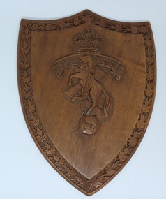
Functional object - RAEME Shield, c1978
RAEME Corps was first established in 1942 when the Ordnance Corps and the Service Corps were combined. The royal ascent was granted in 1948. The Royal Australian Electrical and Mechanical Engineers (RAEME) is a technical corps tasked with the maintenance of the Army's modern hardware and equipment. RAEME personnel are represented in most Army units. The Royal Australian Electrical and Mechanical Engineers corps motto is ‘Arte et Marte’, which is Latin for ‘With Skill and Fighting’. This item, was presented to the Council of the Rural City of Wodonga in 1978. RAEME has a strong connection with the city of Wodonga through its service and training facilities at the Bandiana base on the edge of Wodonga. A shield shaped plaque carved with the emblem of RAEME corps (The Royal Australian Electrical and Mechanical Engineers corps). The edge of the shield is decorated with carved leaves. An engraved metal plate has been attached to acknowledge the presentation of the plaque to the Council of the Rural City of Wodonga. The rearing horse and chain are symbolic of power under control and the lightning flash, of electrical engineering. The rearing horse also forms part of the crest of the Institution of Mechanical Engineers and, together with the lightning flash, is intended to mark the close relationship which exists between the electrical and mechanical engineers in both civil and military life. The globe is indicative of the impact of engineering on the world generally.Attached to rear of shield "Presented to/The Council of the Rural CIty of Wodonga/ by/ The Commanding Officer and Members of/RAEME Training Centre/ 21 October 1978"raeme, australian army -
 Moorabbin Air Museum
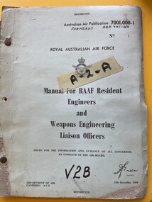
Manual - (SP) AAP 7001.008-1 RAAF Pub 701:40 Manual for RAAF Resident Engineers and Weapons Engineering Liaison Officers, RAAF
... for RAAF Resident Engineers and Weapons Engineering Liaison ... -
 Bendigo Military Museum
Photograph - MAJ Bob Williams – Technical Award Recipient, Army Survey Regiment, Fortuna, Bendigo, 1990
In 1990 MAJ Bob Williams was the OC of Technical Development Cell. He won first prize for his entry ‘Innovations in Cartographic Communication’ in the individual category at the 2nd Australian Institute of Cartographers and BHP Engineering Technology Research and Development Awards. The award was announced at the 1990 Australian Cartographic Conference in Darwin where MAJ Williams presented his entry. At the time he had completed PhD studies at the Australian Defence Academy and was the first Survey Corps officer to complete studies at this advanced level. Also, in 1990 the Royal Australian Survey Corps’ meritorious achievements were formally recognised by the Senate of the Australian Parliament in a Notice of Motion on 31st of May 1990. The Royal Australian Survey Corps also featured in the issue of a commemorative stamped envelope issued by Australia Post. These achievements are covered in more detail in page 147 of Valerie Lovejoy’s book 'Mapmakers of Fortuna – A history of the Army Survey Regiment’ ISBN: 0-646-42120-4. This photograph of MAJ Bob Williams was taken in Technical Development Cell at the Army Survey Regiment, Fortuna, Bendigo in 1990. The black & white photograph was printed on photographic paper and is part of the Army Survey Regiment’s Collection. The photograph was scanned at 300 dpi. .1) - Photo, black & white, 1990. MAJ Bob Williams – Technology Award Recipient.1P – annotated in red pen ‘MAJ Williams Technology Awards’royal australian survey corps, rasvy, army survey regiment, army svy regt, fortuna, asr -
 Melbourne Tram Museum
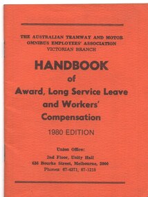
Book, Australian Tramway & Motor Omnibus Employees Association (ATMOEA), "Handbook of Award, Long Service Leave and & Workers Compensation - 1980 edition", "Handbook of Award, Long Service Leave and & Workers Compensation", 1980
Book - orange coloured manila card paper covers, 40 pages + cover centre stapled, titled "Handbook of Award, Long Service Leave and & Workers Compensation - 1980 edition". Has lists of Union Officers, details of gratuities schemes (old and new) - Des Shooter Secretary. Has many advertisements for organisations throughout the book, such as Mercedes-Benz, J.A. Floyd & Co. Ansair, Commonwealth Engineering, Volvo Buses and the Tramways Benefit Society. .1 - as above - 1974 - Secretary R. Edwards - adverts including Ansett Airlines, and Elders GM, Bung and International Harvester.trams, tramways, atmoea, awards, workplace conditions, workers compensation, annual leave, mmtb -
 Melbourne Tram Museum
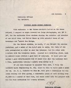
Document - Memorandum, Melbourne & Metropolitan Tramways Board (MMTB), "Victoria House Window Displays", 4/10/1949 12:00:00 AM
Memos - carbon copy on quarto paper - from the Publicity Officer to the Chairman regarding a window display in Victoria House London, dated 4/10/19?9? (Year only typed as a 9). Refers to a letter from Sir Norman Martin. Suggests two large photos of the SW6 trams exterior and interior, and the possibility of a scale model by Meadmore Engineering where Peter Duckett works and notes that Mr. Bell gave him recently a controller. Has a reference to Mr. Bell. Mr Risson commenced work on 1/10/1949 though in correspondence with Paul Nicholson, he felt that 1949 would be correct.Initialled by Lewis Russell.trams, tramways, sw6 class, london, models -
 Melbourne Tram Museum
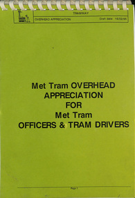
Document, The Met, "Overhead Appreciation - draft", 2/1995
Document - full title "Met Tram Overhead appreciation for Met Tram Officers & Tram Drivers" Gives a detailed inforamation on the structure of the tram overhead, its parts, poles, such as frog pans, crossing pans, points, contactors ,broken trolley wire, pantograph operation and feeder cables. Has notes on the SCADA system and Carlton Electrical control system. Written at the time when trolley poles remained in operation.Yields information about the Melbourne tramway overhead system.Document 47 A4 pages, clear plastic cover, with card covers comb bound along top edge.tramways, tramcars, equipment, overhead, electrical engineering, trolley wire -
 Melbourne Tram Museum
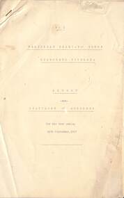
Administrative record - Annual Report/s, Footscray Tramway Trust, "Footscray Tramway Trust", 1917
First Annual Report of the Footscray Tramway Trust, for the year ending 30/9/1917. Lists the Trust Members, Consulting Engineers, and Secretary. Details the Trust's activities, financial loans, construction, car barn, and that it is the first Australian Tramway to use Australian-made rails. Engineering report by McCarty Underwood lists the lines to be built, and rails to use an 80lb/yard NSW railway section with a 30lb/yard bolt-on check rail. Notes the intention to have 7 one-man-operated cars and 3 combination cars. Gives expected cost of operations. Lists the Footscray Council Officers that were involved in the project. Supplementary letter from McCarty Underwood about the cost of the rails and the composite section dated 15/11/1917. Yields information about the construction of the Footscray Tramway Trust tramways.Ten foolscap sheets, duplicated, stapled in top left hand corner.tramways, tramcars, ftt, footscray tramways trust, new tramways, rails, tramway construction, annual reports -
 University of Melbourne, Burnley Campus Archives
Photograph - Black and white print and negative, Peter Esdale, Centenary Celebrations 1991, 1991
19 black and white photographs of staff at a a dinner held at Burnley in the Engineering Building to celebrate the 1991 Centenary. Some staff identified by Ala Shtrauser (former assistant librarian) (1) Geoff Olive (Horticultural Instructor). (5) Geoff Connellan (Senior Lecturer (Sciences)).. (6, 7) Jim Pleasance. (8) Phil Kenyon. (12) Ian Winstone, Kevin Blaze, Clive Sorrell. (13, 15) Ed Smart.((Agricultural Officer) (14) David Aldous.(18) Ivo Dean. staff, dinner, 1991, centenary, ala shtrauser, librarian, geoff olive, horticultural instructor, geoff connellan, lecturer, sciences, jim pleasance, phil kenyon, ian winstone, kevin blaze, clive sorrell, ed smart, agricultural officer, david aldous, ivo dean, 1991 centenary