Showing 1131 items matching "environmentalism"
-
 Eltham District Historical Society Inc
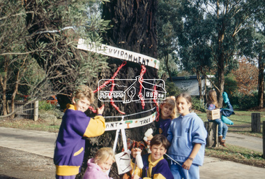
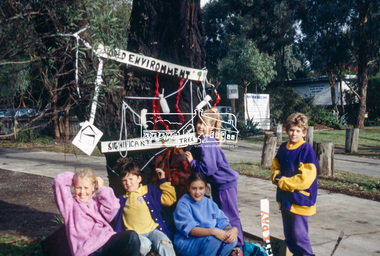
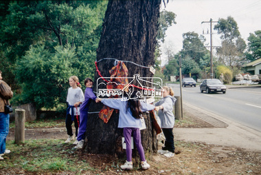
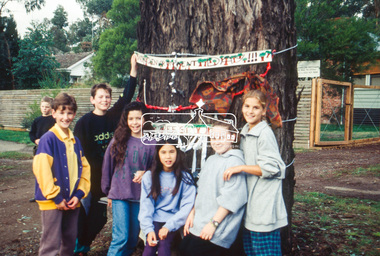
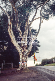
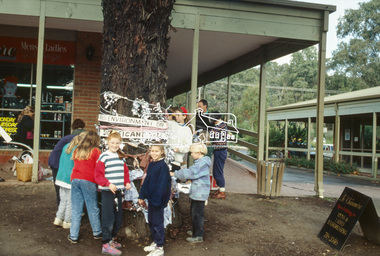
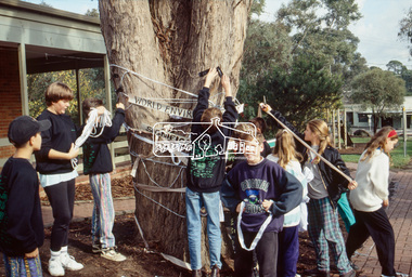
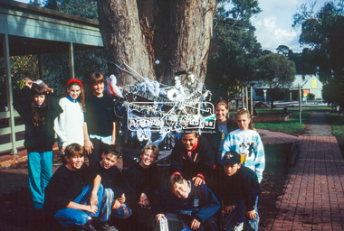
Slide - Photograph, World Environment Day 1993, Yellow Box, Main Road, Eltham, 5 June 1993
World Environment Day was established by in 1972 by the United Nations General Assembly on the first day of the Stockholm Conference on the Human Environment. Two years later, in 1974 the first World Environment Day was held with the theme "Only One Earth" and is observed every year on June 5 to encourage awareness and environmental protection. According to United Nations, "The celebration of this day provides us with an opportunity to broaden the basis for an enlightened opinion and responsible conduct by individuals, enterprises, and communities in preserving and enhancing the environment." 35mm colour positive transparency (1 of 23) Mount - Black and Whiteworld environment day 1993, eltham, eltham east primary school, heritage tree, significant tree, main road, yellow box -
 Eltham District Historical Society Inc
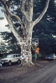
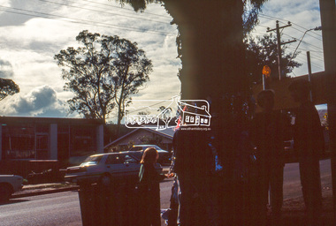
Slide - Photograph, World Environment Day 1993, Sugar Gum, 295 Eltham-Yarra Glen Road, Kangaroo Ground, 5 June 1993
World Environment Day was established by in 1972 by the United Nations General Assembly on the first day of the Stockholm Conference on the Human Environment. Two years later, in 1974 the first World Environment Day was held with the theme "Only One Earth" and is observed every year on June 5 to encourage awareness and environmental protection. According to United Nations, "The celebration of this day provides us with an opportunity to broaden the basis for an enlightened opinion and responsible conduct by individuals, enterprises, and communities in preserving and enhancing the environment." 35mm colour positive transparency (1 of 23) Mount - Black and Whiteworld environment day 1993, heritage tree, significant tree, eltham-yarra glen road, kangaroo ground, sugar gum -
 Eltham District Historical Society Inc
Slide - Photograph, World Environment Day 1993, Heidelberg-Kinglake Road, Hurstbridge, 5 June 1993
World Environment Day was established by in 1972 by the United Nations General Assembly on the first day of the Stockholm Conference on the Human Environment. Two years later, in 1974 the first World Environment Day was held with the theme "Only One Earth" and is observed every year on June 5 to encourage awareness and environmental protection. According to United Nations, "The celebration of this day provides us with an opportunity to broaden the basis for an enlightened opinion and responsible conduct by individuals, enterprises, and communities in preserving and enhancing the environment." 35mm colour positive transparency (1 of 23) Mount - Black and Whiteworld environment day 1993, heritage tree, significant tree, heidelberg-kinglake road, hurstbridge, hurstbridge shopping centre -
 Federation University Historical Collection
Essay - Document, Anne Beggs Sunter, Mining the Education Lode: The History of Mining Education in Ballarat by Anne Beggs Sunter
"Mining the Education Lode: The History of Mining Education in Ballarat" by Anne Beggs Sunter covers the Early History, Community Impact, Decline of Gold Mining, New Avenues, The Baby Boomers, Mergers and New Directions, The 1990s, Innovations, Associateship to Degree, Staff, Heads of Department, Graduates, Scholarships and Prizes, Architectural Heritage, Occupational Health and Safety and Environmental Management (Rehabilitation), relating to the Ballarat School of Mines. Anne Beggs-Sunter is an historian who lectures in the School of Arts at Federation University Ballarat.26 A4 page thesis concerning the history of mining education in Ballarat. ballarat school of mines, school of mines, mining education, ballarat, anne beggs-sunter, beggs-sunter, anne beggs sunter, mining the education lode, alumni, mining, gold mining -
 Bendigo Historical Society Inc.
Document - Australian Defence Industries (ADI) - two Capability Statements booklets
Australian Defence Industries (ADI) - two Capability Statements booklets: a) ADI red logo on front cover. Statement for "ADI Limited Group, Engineering". End of each page identifies: CS-JAN99. Table of contents on first page Vision Mission statements, ADI Ltd, ADI Engineering Organisation, Structure, Customer Profile, Projects Bendigo & Lithgow Facilities, Quality, Safety & Environmental Policies. Paper statements with thick card binding. b0 ADI red logo and plant photos on front cover with title "ADI's heavy and Precision Engineering Facility Bendigo Aust." First page statement Oct 1997. Next page contents includes ADI Ltd. and introduction to Bendigo Factory.local history, adi history -
 The Beechworth Burke Museum
Geological specimen - Chalcopyrite
This specimen originated from Mount Lyell on the west coast of Tasmania, where a large group of open cut and underground copper-silver-gold mines began operating in 1883. Between 1893-1994, the Mt Lyell Mining and Railway Company were responsible for operations. The Mt Lyell copper-gold mines produce some excellent crystallised specimens of chalcopyrite and other minerals. The deposits are generally considered to be of Cambrian volcanic origin, but there are indications of Devonian granitic influence on the ores, plus local remobilisation during Devonian deformation. Over 120 million tonnes of ore was produced from several workings, including the main Prince Lyell mine and the North Lyell mine, which was also of great importance. The Mount Lyell mines have a long history of human and environmental disasters, including the 1912 North Lyell fire that killed 42 miners, and two separate incidents in 2013 in which three people lost their lives. The environmental impacts from this complex of mines are extensive, with waste tailings and heavy metal contamination flowing directly into the King and Queen River catchments. In 1954, the eminent Australian historian, Geoffrey Blainey, published 'The Peaks of Lyell' which delves into the history of the 1912 North Mount Lyell Disaster.Chalcopyrite does not contain the most copper in its structure relative to other minerals, but it is the most important copper ore since it can be found in many localities and occurs in a variety of ore types. The brassy-yellow colours in Chalcopyrite mean it is often confused with pyrites and gold, leading to use of the term, "fool's gold." Chalcopyrite has been the primary ore of copper since smelting began five thousand years ago. This specimen is part of a larger collection of geological and mineral specimens collected from around Australia (and some parts of the world) and donated to the Burke Museum between 1868-1880. A large percentage of these specimens were collected in Victoria as part of the Geological Survey of Victoria that begun in 1852 (in response to the Gold Rush) to study and map the geology of Victoria. Collecting geological specimens was an important part of mapping and understanding the scientific makeup of the earth. Many of these specimens were sent to research and collecting organisations across Australia, including the Burke Museum, to educate and encourage further study.This hand sized solid mineral specimen has shades of brass-yellow with spots of iridescent green-black tarnish. Chalcopyrite is a copper iron sulphide mineral and a major ore of copper common in sulphide veins and disseminated in igneous rocks. Chalcopyrite has a hardness of 3.5-4 on the Mohs Scale. It is a member of the tetragonal crystal system and has metallic lustre and opaque transparency.burke museum, beechworth, indigo shire, beechworth museum, geology, geological specimen, chalcopyrite, copper pyrites, copper mining, tasmanian geology, mount lyell, mount lyell mines, fools gold, mohs scale, crystals, minerals, historical geological collection, victorian geological survey, a.r.c selwyn, gold rush, van diemans land -
 Eltham District Historical Society Inc
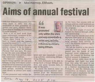
Newspaper - Newspaper clipping, Diamond Valley Leader, Aims of annual festival, Mal Harrop, 2005
Opinion piece by Mal Harrop, Eltham regarding the origina of the first Eltham Communitry Festival in 1975, the brainchild of then Shire President, Alistair Knox. Discusses the funding of the festival with the help of Eltham Apex Club Ltd leading to the Eltham Ohienix Club which ran the festival for the next nine years with assistance from service cluybs and community members. Discusses the original objective of the festival toi bring together old and new Eltham, to help newcomers undersrtand the environmental and artistic heritage of the area, and to help local groups and schools to raise money and attract new members.Newsprinteltham festival, 2005, eltham community festival, rotary club of eltham, rotary eltham town festival, eltham phoenix club, eltham apex club, alistair knox, graeme bell, montmorency garden club, montsalvat jazz festival -
 Queenscliffe Maritime Museum
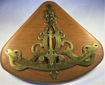
Instrument - Brass Inclinometer
Various artifacts from the steamship 'Wattle'. The Steam Tug Wattle, a steel ship, was built as a harbor tug in 1933. Steam is supplied from a two-furnace Scotch Marine wet-back boiler which was originally fired with dewatered and filtered waste oil but has recently been converted to burn distillate for environmental and maintenance reasons. It was launched at Cockatoo Island on 27 June 1933 by Cockatoo Docks & Engineering Co. Ltd. (CODECO) on order from the Commonwealth Shipping Board. Now fully restored it operates excursions in Port Phillip and the Yarra. One of a very few still operating steam tugs.Brass inclinator mounted on timber plate.steam tug wattle, harbour tugs -
 Queenscliffe Maritime Museum
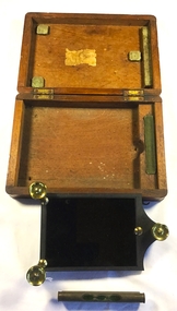
Instrument - Solar reflector
Various artifacts from the steamship 'Wattle'. The Steam Tug Wattle, a steel ship, was built as a harbor tug in 1933. Steam is supplied from a two-furnace Scotch Marine wet-back boiler which was originally fired with dewatered and filtered waste oil but has recently been converted to burn distillate for environmental and maintenance reasons. It was launched at Cockatoo Island on 27 June 1933 by Cockatoo Docks & Engineering Co. Ltd. (CODECO) on order from the Commonwealth Shipping Board. Now fully restored it operates excursions in Port Phillip and the Yarra.Solar Reflector with spirit level in wooden boxst wattle, navigational intruments -
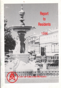 Bendigo Historical Society Inc.
Book - BOOKLET: REPORT TO RESIDENTS CITY OF GREATER BENDIGO, 1996
Front cover is a photo of Alexandra Fountain. 52 paged booklet - ''Report to Residents - City of Greater Bendigo, 1995. Table of Contents; The Mayor; Chief Executive Officer; Council meetings; Office location and hours; ''One Telephone Number''; Locations of functions and business; Units; Organisation Structure; Advisory Committee; Municipal Boundaries; Customer services; Economic development; Bendigo Tourism; Bendigo Trust; Events Bendigo; Capital works 1996/97; Bendigo Regional Arts Centre; Local laws; Aged and disability services; Children and family services; Environmental health; Recreation and leisure; Parks and gardens; Planning and building; Waste management in Bendigo; Library services; Rates; Budget for 1996/97; The budget at a glance; Index.bendigo, council, report -
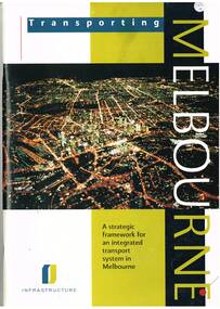 Melbourne Tram Museum
Book, Department of Infrastructure (DOI), "Transporting Melbourne - a Strategic framework for an integrated transport system in Melbourne", Sep.1996
Book - 92 pages, centre stapled, printed on gloss paper titled "Transporting Melbourne - a Strategic framework for an integrated transport system in Melbourne", issued September 1996. Has a message from Minister Alan Brown - Minister for Transport and Geoff Craige Minister for Roads and Ports. Looks at the strategic context, the system, integration and land use, public transport needs and reforms, road networks, industry, management, environmental sustainability and structural reform. Includes chapters on trams and buses. Has many figures and maps. 613.1 - Book - 28 pages centre stapled, printed on gloss paper titled "Transporting Melbourne - A summary for public consolation" issued Sept. 1996, summary of above document. Full pdf image of the book added.trams, tramways, melbourne, public transport, transport -
 Eltham District Historical Society Inc
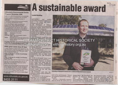
Document - Property Binder, 1184 Main Road, Eltham
Newspaper article: A sustainable award, Diamond Valley Leader, 1 November2006, Architect and building Llewellyn Pritchard won resource Efficiency Housing Award, finalist in HIA Greensmart Building of the Year Award. House – Environmental Leader (Published: Nillumbik Now and Then / Marguerite Marshall 2008; photographs Alan King with Marguerite Marshall.; p186) In 2006 environmental awareness was mushrooming in the community, which is reflected in the award-winning house at Main Road near Wattletree Road, Eltham. At first sight, the building appears a mix of a classic Eltham mud-brick house and an avant-garde building style. The crown of solar panels stretching along the width of the curved roof, indicates that this is no ordinary house. In fact it signals a new building trend of minimal impact on the environment. Yet it utilises the environment with high technical expertise to achieve comfort and cut running and maintenance costs. In recognition of this, its designer/builder, Conscious Homes, won the 2006 National HIA Greensmart Resource Efficiency Award. For Conscious Homes director, Llewellyn Pritchard, this house reflects a philosophy, strengthened by his connection with Aboriginal culture, through his foster siblings. Pritchard believes the sustainable way indigenous Australians lived and their spiritual connection with land, demonstrates how humanity is part of the ecology. His interest in environmental design stemmed from growing up in bushy Eltham Shire, with its mud-brick tradition. This was followed by studying Architecture at RMIT in the early 1980s, and learning about passive solar design. Pritchard says this house demonstrates that environmental sustainability is not about sacrifice, but about exceptional levels of occupant comfort, savings in running costs and modern fittings and appliances.1 The solar panels on the north roofs are intentionally obvious to make a statement about what the building is doing. But inside the systems are hidden and interactive with conventional services, such as the underground water tank. The house is water and energy self-sufficient and at 12 squares is much smaller than conventional houses, to minimise resources. Yet it accommodates his family of four with three bedrooms, a living/dining and kitchen area and a bathroom/laundry. Importantly the building is designed to last hundreds of years, by being able to be modified as the need arises, such as for commercial use. In this way the structure minimises its environmental impact. The solid double mud-brick walls (which are insulated) include steel beams and supporting frame, allowing the future removal or alteration of any section. The materials are local, recycled and of low toxicity where possible.2 Inside and out, the mud-brick is rendered and sealed with a combination of cement and sand and a mud-based coating in a soft golden hue increases its life. Inside, the golden-brown timber is plantation Mountain Ash and the concrete floors throughout – of local stone aggregate with a clear seal – have a natural looking random stone appearance. The house sustains a stable temperature of around 20 degrees, assisted by the concrete slab floor. The many large double-glazed windows and highlights (windows set high on walls) provide cross-flow ventilation. The north-facing living area maximises heating from the lower winter sun and is cooler in summer, because the sun is higher. Heating comes from a solar hydronic slab system. All appliances and fittings are high efficiency energy or water rated. Appliances in the timber kitchen include a gas stove and a dishwasher, using the building’s own power and water. French doors open from the living area to a deck, concealing the treatment system for all waste water. This is pumped through sub-soil drippers to the indigenous garden beds and no-dig vegetable patch. Below the carport is the 80,000-litre rainwater tank and at the back, the boiler room houses the solar boiler, water tank access, domestic water supply pump, filter gear and hydronic slab heating controls. The solar system is backed up with gas, which is needed to heat water only in winter. Gas used is less than one quarter of that for an average home with ducted heating. Excess power is fed back to the grid and the building uses about one quarter of the mains electricity of an average home. Other local builders have followed Pritchard’s lead in resource efficiency for minimal environmental impact.main road, eltham, businesses, llewellyn pritchard, hia greensmart building of the year award., efficiency housing award, conscious homes australia pty ltd -
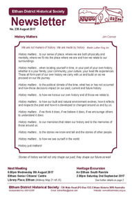 Eltham District Historical Society Inc
Newsletter, Newsletter, No. 235 August 2017
Contents: • History Matters by Jim Connor • 9th August Meeting - The Shallards of Montmorency • Heritage Excursion - Saturday 2nd September - An Eltham South Ramble • Montmorency Guiding Memories by Jean Ryan • Percy Leason: An Artist's Life by Margot Tasca - Book review by Russell Yeoman • Eltham District Historical Society: Russell Yeoman by Jim Connor • 40 Years of Environmental Living by Janet Mattiske • Membership Subscriptions • Wellers Hotel of Kangaroo Ground - Part 1 by Jim Allen • Morrison Kleeman Real Estate • Our Sponsors • Contacts for the Eltham District Historical Society The Shire of Eltham Historical Society was formed in October 1967. The first newsletter of the Society was issued May 1978 and has been published continuously ever since on a bi-monthly basis. With the cessation of the Shire of Eltham in late 1994, the Society's name was revised to Eltham District Historical Society and this name first appeared with issue No. 103, July 1995. The collection of the Society's newsletters provides a valuable resource on the history of the Society's activities, office bearers and committee members, guest speakers and subjects of historical interest pertinent to the former Shire of Eltham and the Eltham District.A4 photocopied newsletter distributed to membersnewsletter, eltham district historical society, shire of eltham historical society -
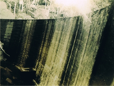 Kiewa Valley Historical Society
Photograph Clover Dam, Clover Dam Circa 1940, circa 1940s to 1950s
As part of the push to cut electricity costs and diversify supply, the Victorian Government (circa 1930) implemented the conversion strategy from mainly brown coal supply to hydro - electricity. The Kiewa Hydroelectric Scheme became the largest scheme of its kind in the State Of Victoria and the second largest scheme in Australia. This dam was constructed to supply water to feed four turbines (62 mega watts) at the West Kiewa Power Station. This was at the forefront of sustainable "Green" energy. Costs associated with power supplies is still a major incentive of governments, however environmentally friendly alternatives such as wind and nuclear have also made inroads. The Kiewa valley and its surrounding alpine catchment were looked at(Victorian State Government), from the beginning of the twentieth century as a source of alternate power for an every increasing demand for electricity by growing population and heavy industrial ares within Melbourne City and State regions. Construction of dams, such as Clover Dam provided the large quantity holding areas of water required to turn the turbines at the various power stations to provide the electricity needed. The impact of these controls by moderating water run off from the alpine regions is beneficial in reducing flooding from thawing of snow on the alps. This by-product allows agriculture and grazing to be less vulnerable to seasonal flooding thereby resulting in a more stable annual production level.Reproduction (scanned) of a black and white photo of Clover Dam circa 1940. The paper used is KodakXtraLife II paperThe reverse side of photo " KodakXtraLife II paperdams, pondage, hydro electricity, power stations, clover dam, secv -
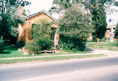
 Eltham District Historical Society Inc
Photograph, Looking west along Bridge Street, Eltham from Main Road; 15 April 1989, 15/04/1989
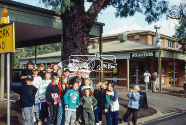
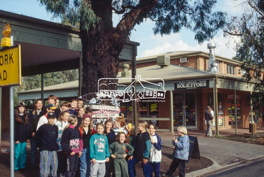
[from EDHS Newsletter No. 65, March, 1989:] ELTHAM HERITAGE WALK The Society's contribution to Heritage Week this year will be a guided walk around Eltham featuring a number of buildings and locations of historical and environmental interest. Three dates are listed as official Heritage Week events, Sundays 16th and 23rd April and Saturday 22nd. In addition, there will be a walk on Saturday 15th for Society Members. All walks will start at 1:00 p.m. in Panther Place near Shillinglaw Cottage. Each will take about four hours and the distance is about 5km. Old photos of locations visited will be available for viewing.Two colour photographsactivities, bridge street, eltham, heritage excursion, main road -
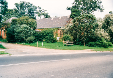
 Eltham District Historical Society Inc
Photograph, Looking north along Bridge Street, Eltham from Main Road; 15 April 1989, 15/04/1989
[from EDHS Newsletter No. 65, March, 1989:] ELTHAM HERITAGE WALK The Society's contribution to Heritage Week this year will be a guided walk around Eltham featuring a number of buildings and locations of historical and environmental interest. Three dates are listed as official Heritage Week events, Sundays 16th and 23rd April and Saturday 22nd. In addition, there will be a walk on Saturday 15th for Society Members. All walks will start at 1:00 p.m. in Panther Place near Shillinglaw Cottage. Each will take about four hours and the distance is about 5km. Old photos of locations visited will be available for viewing.Colour photographactivities, bridge street, eltham, heritage excursion, main road -
 Eltham District Historical Society Inc
Photograph, Clark and Wise, Milk Bar, former Burgoyne shop, 820 Main Road, Eltham; 15 April 1989, 15/04/1989
[from EDHS Newsletter No. 65, March, 1989:] ELTHAM HERITAGE WALK The Society's contribution to Heritage Week this year will be a guided walk around Eltham featuring a number of buildings and locations of historical and environmental interest. Three dates are listed as official Heritage Week events, Sundays 16th and 23rd April and Saturday 22nd. In addition, there will be a walk on Saturday 15th for Society Members. All walks will start at 1:00 p.m. in Panther Place near Shillinglaw Cottage. Each will take about four hours and the distance is about 5km. Old photos of locations visited will be available for viewing.Colour photographactivities, heritage excursion, main road, burgoyne store, milk bar, shops -
 Eltham District Historical Society Inc
Photograph, Former CBA bank, 810 Main Road, Eltham near John Street; 15 April 1989, 15/04/1989
[from EDHS Newsletter No. 65, March, 1989:] ELTHAM HERITAGE WALK The Society's contribution to Heritage Week this year will be a guided walk around Eltham featuring a number of buildings and locations of historical and environmental interest. Three dates are listed as official Heritage Week events, Sundays 16th and 23rd April and Saturday 22nd. In addition, there will be a walk on Saturday 15th for Society Members. All walks will start at 1:00 p.m. in Panther Place near Shillinglaw Cottage. Each will take about four hours and the distance is about 5km. Old photos of locations visited will be available for viewing.Colour photographactivities, heritage excursion, main road, eltham, john street, cba bank -
 Eltham District Historical Society Inc
Photograph, Uniting Church, cnr Main Road and John Street, Eltham; 15 April 1989, 15/04/1989
[from EDHS Newsletter No. 65, March, 1989:] ELTHAM HERITAGE WALK The Society's contribution to Heritage Week this year will be a guided walk around Eltham featuring a number of buildings and locations of historical and environmental interest. Three dates are listed as official Heritage Week events, Sundays 16th and 23rd April and Saturday 22nd. In addition, there will be a walk on Saturday 15th for Society Members. All walks will start at 1:00 p.m. in Panther Place near Shillinglaw Cottage. Each will take about four hours and the distance is about 5km. Old photos of locations visited will be available for viewing.Colour photographactivities, heritage excursion, main road, eltham, john street, uniting church -
 Eltham District Historical Society Inc
Photograph, Eltham Community Centre; 15 April 1989, 15/04/1989
[from EDHS Newsletter No. 65, March, 1989:] ELTHAM HERITAGE WALK The Society's contribution to Heritage Week this year will be a guided walk around Eltham featuring a number of buildings and locations of historical and environmental interest. Three dates are listed as official Heritage Week events, Sundays 16th and 23rd April and Saturday 22nd. In addition, there will be a walk on Saturday 15th for Society Members. All walks will start at 1:00 p.m. in Panther Place near Shillinglaw Cottage. Each will take about four hours and the distance is about 5km. Old photos of locations visited will be available for viewing.Colour photographheritage excursion, activities, eltham community centre -
 Eltham District Historical Society Inc
Photograph, Eltham Hotel, cnr Main Road and Pitt Street; 15 April 1989, 15/04/1989
[from EDHS Newsletter No. 65, March, 1989:] ELTHAM HERITAGE WALK The Society's contribution to Heritage Week this year will be a guided walk around Eltham featuring a number of buildings and locations of historical and environmental interest. Three dates are listed as official Heritage Week events, Sundays 16th and 23rd April and Saturday 22nd. In addition, there will be a walk on Saturday 15th for Society Members. All walks will start at 1:00 p.m. in Panther Place near Shillinglaw Cottage. Each will take about four hours and the distance is about 5km. Old photos of locations visited will be available for viewing.Colour photographheritage excursion, activities, main road, eltham hotel