Showing 411 items
matching evans road
-
 Hume City Civic Collection
Photograph, c 1980s
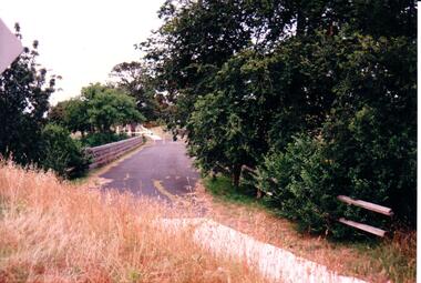
... macedon street road bridge george evans collection A coloured ...The stone bridge was the only entry into Sunbury on the eastern side of the town and was in use until the road was re-routed and widened in the 1970s.A coloured photograph of the roadway over the Macedon Street bridge which spans Jacksons Creek. There is a grassy area in the foreground with trees growing either side of the bridge. The narrow asphalted surface of the road across the bridge is cut off by a low stone wall.stone bridges, jacksons creek, macedon street road bridge, george evans collection -
 Hume City Civic Collection
Photograph, late 1980s
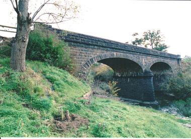
The road bridge over Jackson's Creek in Sunbury was built in 1870 and was in use until a wider bridge was built when Sunbury Road was rebuilt in the early 1970s.A coloured photograph taken from the NE side of the river bank of a complete view of the bluestone bridge at Macedon Street. The two eliptical arches and the protruding pylon as well as the underside of the bluestone span are clearly visible.transport, roads and bridges, jacksons creek, harris, thomas lascelles, george evans collection -
 Hume City Civic Collection
Photograph, 1980s
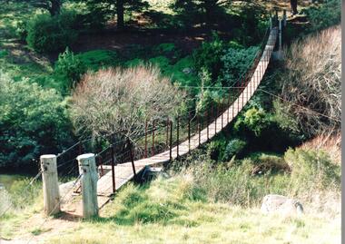
The timber and cable swing bridge straddled the Deep Creek at Bulla behind the Bulla school. It enabled children who lived across the river to travel directly to school instead of going the long way around the road, a possible distance of 2-3 kms.A coloured photograph of the timber and cable swing bridge which was constructed across the Deep Creek at Bulla. Trees are growing along the river bank and there is a row of conifers growing along the opposite bank.swing bridges, deep creek, george evans collection -
 Hume City Civic Collection
Photograph, late 1990s
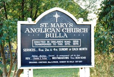
St. Mary's Anglican Church at Bulla was originally built on the outskirts of Bulla township in 1858. In the early 1970s it was moved to its present site to make way for the flight path at the newly constructed Tullamarine Airport. The former site was on the corner of Oaklands and Sunbury Roads and is covered with vegetation. The church was designed by Thomas Taylor.A coloured photograph of the board which is along the fence line outside St. Mary's Church at Bulla. The white writing is on a navy blue background and is framed in white. The notice gives details of services, clergy and caretaker.churches, religion, anglican church, taylor, thomas, potter, charles e. rev., prior, a., st. mary's anglican church, george evans collection -
 Hume City Civic Collection
Photograph, late 1990s
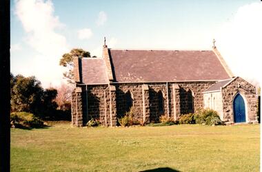
St. Mary's Anglican Church at Bulla was originally built on the outskirts of Bulla township in 1858. In the early 1970s it was moved to its present site to make way for the flight path at the newly constructed Tullamarine Airport. The former site was on the corner of Oaklands and Sunbury Roads and is covered with vegetation. The church was designed by Thomas Taylor.A profile view of the west side of St. Mary's Anglican Church at Bulla and the garden area around the church. A slate covered gable roof has been constructed over the porch nave and chancery with a cross at each end of the roof over the nave. 6 bluestone buttresses and 3 lance windows are along the side with 3 small lancet windows and a blue painted wooden lancet door on the porch.churches, religion, taylor, thomas, st. mary's anglican church, george evans collection -
 Hume City Civic Collection
Photograph, early 1990s
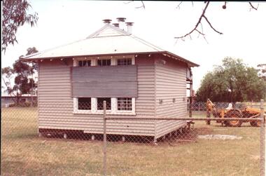
The small one roomed school is closed at the site along the Calder Highway and was relocated to the new school building in Plumpton Road at Diggers Rest. The former school building became the club rooms for the Diggers Rest Bowling Club when the new school opened in the late 1980s.A coloured photograph of the former Diggers Rest Primary School. The small one roomed weatherboard building with a corrugated iron roof has sheets of iron across the windows. The building is being prepared for relocation. A post hole digger is behind the building.diggers rest primary school, education department, diggers rest bowling club, george evans collection -
 Hume City Civic Collection
Photograph, early 1990s
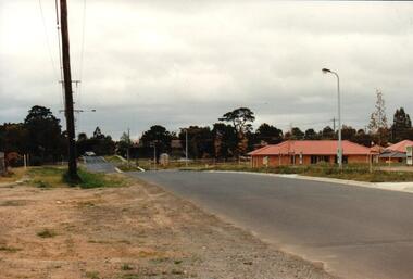
... township. housing developments anderson road george evans ...The series of 5 photographs feature different views of the Woodlands Housing Development which opened up land bounded by Gap and Anderson Roads, Cornish Street and Elizabeth Drive in the early 1990s. It was a large housing development built close to Sunbury township.A coloured photograph of one of the last housing developments which took place in the old township area. It is a photograph taken at the north end of Anderson Road looking towards Gap Road. One house has been built and there are a number of 'For Sale' signs of blocks fronting Anderson Road. Guttering and driveways have been formed on one side of the road.housing developments, anderson road, george evans collection -
 Hume City Civic Collection
Photograph, early 1990s
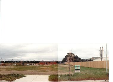
... township. housing developments anderson road george evans ...The series of 5 photographs feature different views of the Woodlands housing development which opened up land bounded by Gap and Anderson Roads, Cornish Street and Elizabeth Drive in the early 1990s. It was a large housing development built close to Sunbury township.A view of the northern boundary of the Woodlands housing development in Anderson Road. A paling fence divides the estate from the 'Malley' factory, now 'Storage King' which is on the corner of Cornish Street and Anderson Road. A 'For Sale' sign is in the foreground and a partly built house is in the middle distance.housing developments, anderson road, george evans collection -
 Hume City Civic Collection
Photograph, early 1990s
... township. housing developments anderson road george evans ...The series of 5 photographs feature different views of the Woodlands housing development which opened up land bounded by Gap and Anderson Roads, Cornish Street and Elizabeth Drive in the early 1990s. It was a large housing development built close to Sunbury township.A coloured photograph of a new housing development taken in Anderson Road looking west towards Elizabeth Drive and the leisure centre. Some housing construction is in the middle distance.housing developments, anderson road, george evans collection -
 Hume City Civic Collection
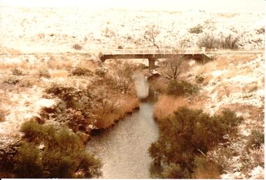
Photograph, 1/08/1986
... for the area. snow falls weather patterns winter konagaderra road ...A series of photographs were taken when heavy snow fell in Sunbury in August 1986. The snow began falling overnight and remained on the ground for 24 hours. Snow fell across the metropolitan area during that 24 hour period in a very unusual event for the area.A coloured photograph of a snow scene taken near the bridge on the Konagaderra Road near Sunbury.snow falls, weather patterns, winter, konagaderra road, george evans collection -
 Hume City Civic Collection
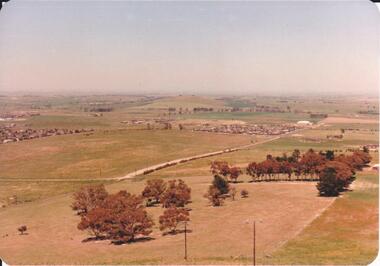
Photograph, 1980s
The photograph was taken above Reservoir Road on the lower slopes of Mt. Holden. It is looking south down Wilson's Lane towards some of the early Sunbury developments which grew around the Gap Road area in the early 1980s.A landscape coloured photograph with rounded corners. It is a panoramic view of Sunbury taken from the southern slopes of Mt. Holden. In the foreground there is a small cluster of trees and in the middle distance there is some evidence of housing development. Bald Hill can be seen on the skyline.wilson's lane, mt. holden, bald hill, sunbury, george evans collection -
 Hume City Civic Collection
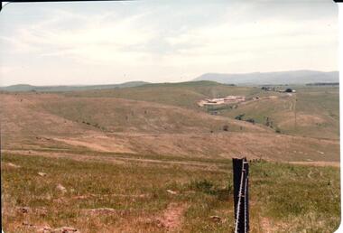
Photograph, early 1980s
The Sunbury Tip was transferred from the end of Reservoir Road as housing development spread in that area to a site on the NW side of Mt. Holden near Riddell Road in the early 1980s.A landscape coloured photograph with rounded corners. It is a panoramic view of open country NW of Sunbury near Riddell Road. There is a fence post with barbed wire hanging from it in the immediate foreground and Macedon Ranges and part of the Western Highlands can be seen across the skyline.macedon ranges, mt. macedon, camel's hump, sunbury municipal tip, george evans collection -
 Hume City Civic Collection
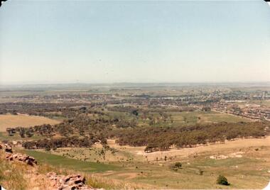
Photograph, early 1980s
The photograph shows the extent of Sunbury's development to the west of the town in the early 1980s. The settlement at this stage extended along either side of Gap Road for about 0.5 km beyond Elizabeth Drive.A coloured landscape photograph with rounded corners taken from Mt. Holden and looking towards the expanding town of Sunbury. The Melba Avenue drain which flows into Blind Creek is in the foreground. Sheoak Hill, the site of the former Sunbury Asylum is in the middle of the skyline.sunbury township, reservoir road, mt. holden, sunbury asylum, george evans collection -
 Hume City Civic Collection
Photograph, early 1980s
The Headland Estate housing development began in the early 1980s. It was situated west of Sunbury and was bounded by Elizabeth Drive, Reservoir Road, Phillip Drive and Stewart's Lane.A coloured landscape photograph with rounded corners of a view of Sunbury overlooking the Headland Estate before its development. There is a rocky outcrop on the LHS of the photograph and a lightly timbered area in the middle distance. Sunbury can be seen in the distance.headland estate, mt. holden, sunbury township, george evans collection -
 Hume City Civic Collection
Photograph
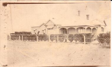
... road george evans collection on back: Bayview-111 Davis Rd ...A sepia photograph Bayview Farm at 111 Davis Road, Diggers Reston back: Bayview-111 Davis Rd / Diggers Restcullinan, uraina, eileen, bayview farm, diggers rest, davis road, george evans collection -
 Hume City Civic Collection
Photograph
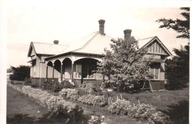
... davis road george evans collection on back: BAYVIEW / 111 DAVIS ...A black and white photograph of a weatherboard house and garden known as Bayview Farm at Diggers Rest. It is the home of Uraina and Eileen Cullinan situated at 111 Davis Road, Diggers Rest.on back: BAYVIEW / 111 DAVIS ROAD / DIGGERS RESTcullinan, uraina, eileen, diggers rest, bayview farm, chris, davis road, george evans collection -
 Hume City Civic Collection
Photograph
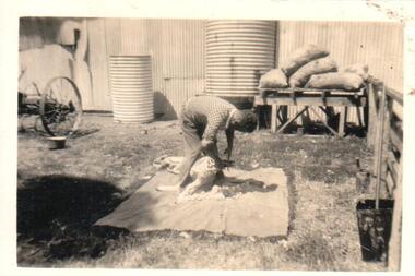
... davis road farmers shearers george evans collection on back ...A black and white photograph of a man shearing a sheep with shears in a farmyard with water tanks in the background with a stack of feed bags. The property if Bayview Farm, Davis Road, Diggers Rest.on back: BAYVIEW / DAVIS ROAD / DIGGERS RESTcullinan, uraina, eileen, diggers rest, bayview farm, chris, davis road, farmers, shearers, george evans collection -
 Hume City Civic Collection
Photograph, c1913
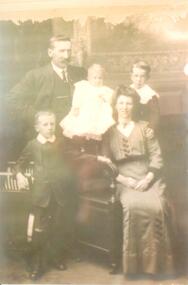
A family photograph of Chris Cullinan Snr., his wife Eileen, his sons Herbert and Chris. Jnr and daughter Rose at Bayview Farm, Diggers Rest.on back in ink: CULLINAN FAMILY c1913 / "Bayview"/111 Davis Road /Diggers Rest/ CHRIS. SNR. EILEEN. Herbert/Chris Jnr/Rosecullinan, uraina, eileen, chris, rose, bayview farm, diggers rest, farm, clothing and dress, george evans collection -
 Hume City Civic Collection
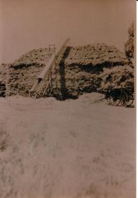
Photograph, c1934
A sepia photograph of a haystack being built with a bale elevator at the side and a hay cart at the end at Bayview Farm.on back in ink: HAYSTACK AT 'BAYVIEW'/ABOUT 1934 / 60' (feet) long, 20' (feet) high, 25' (feet) wide / ELEVATOR APPROX 25' (feet) long / 70-100 tons of hay / "Bayview" / 111 DAVIS ROAD / DIGGERS REST 3427cullinan, uraina, eileen, chris, bayview farm, diggers rest, farms, farming, clothing and dress, harvesting, haystacks, george evans collection -
 Hume City Civic Collection
Photograph, 1920-1929
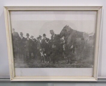
A black and white photograph of twelve men, one horse and three greyhounds in a white wooden frame with glass, at a meeting of the Plumpton Greyhound Races. George Evans (Micko) is standing on the left of the horse's nose; Frank Evans is holding the horse and Bill Aitken is in the light coloured cardigan and bow tie.sports and recreations, greyhound racing, dogs, whelan, kevin, evans, george, aitken, william, kelly, john, frank, plumpton road, diggers rest, plumpton greyhound races, george evans collection -
 Hume City Civic Collection
Photograph, 1920-1929
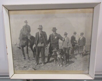
A black and white photograph of men, one horse and four greyhounds in a white wooden frame with glass, at a meeting of the Plumpton Greyhound Races. George Evans (Micko) is pictured second from left; Frank Evans is on the horse and Bill Aitken is in the light coloured cardigan.sports and recreations, greyhound racing, dogs, whelan, kevin, evans, george, aitken, william, kelly, john, frank, plumpton road, diggers rest, plumpton greyhound races, george evans collection -
 Hume City Civic Collection
Photograph, 1920-1929
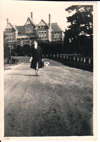
Mrs Hayes worked at the Asylum as a nurse.A black and white photograph of Mrs Dorothy Hayes walking down the road at the Sunbury Asylum. Unmountedsunbury asylum, hospitals, sunbury mental hospital, hays, dorothy (mrs), wilson, dorothy (miss), nurses, george evans collection -
 Hume City Civic Collection
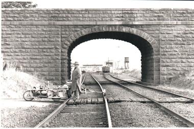
Photograph, Pre 1989
The bluestone 'road over rail' bridge at Macedon Street is of state architectural, architectural, historical and engineering significance. It spans the first government regional railway. Its design and building was done according to strict English standards and made use of a bridge crossing instead of a level road crossing.A black and white photograph of a stone bridge with an eliptical arch spanning two rail tracks. A workman is standing between one set of tracks in the foreground and a railcart is next to the tracks. The station, footbridge and water tower are visible through the arch.road over rail bridge, bridges, sunbury railway station, water towers, pedestrian bridges, stone bridges, george evans collection -
 Hume City Civic Collection
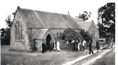
Photograph, c1930s
St Mary's Anglican Church was originally built on land in Oaklands Road. It was licensed in 1859 by Bishop Perry, the first Anglican bishop of Melbourne. In the late 1960s the church was dismantled and rebuilt on its present site at Bulla, adjacent to the former Council Chambers. it was shifted to the township of Bulla because the building was under the direct path of a proposed future flightpath.vintage cars, churches, st. mary's anglican church - bulla, george evans collection -
 Hume City Civic Collection
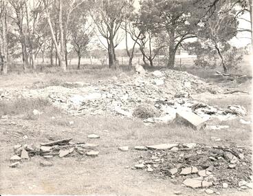
Photograph, late 1960s
... anglican church - bulla oaklands road graveyards george evans ...In the late 1960s St. Mary's Anglican Church was dismantled from its Oaklands Road site and rebuilt on land in Bulla township adjacent to the old shire offices. It was moved because of the interference it would create for aircraft landing in the new Melbourne Airport at Tullamarine. The site has been left timbered because some of the district's early settlers were buried in the church yard before the Bulla Cemetery was established.A black and white photograph of the site of the former St. Mary's Anglican Church at Oaklands Road. There are heaps of building rubble in the foreground and trees in the background.st. mary's anglican church - bulla, oaklands road, graveyards, george evans collection -
 Hume City Civic Collection
Photograph, 1970s
The bluestone bridge which spans the Jacksons Creek was built in 1857 and replaced a laminated timber bridge. In the 1970s the stone bridge was replaced with a wider cement structure to accommodate the increased traffic flow.A black and white photograph of the bluestone Macedon road bridge over the Jacksons Creekmacedon street road bridge, harris, thomas lascelles, jacksons creek, george evans collection -
 Hume City Civic Collection
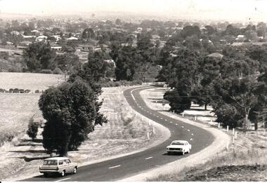
Photograph, Early 1970s
In the early 1970s the eastern approach to Sunbury was changed. The stone bridge spanning the Jacksons Creek was replaced by a wider concrete structure and dangerous curves were taken out of the road. The area on the LHS of the photograph including the two arched stone bridge has been incorporated into a public picnic area.A black and white panoramic view of the eastern approach to Sunbury and the Sunbury township before the road was widened and straightened and the new bridge was built. There are two cars in the foreground. One is approaching the bridge and the other is leaving Sunbury.macedon street, macedon street road bridge, jacksons creek, sunbury township, george evans collection -
 Hume City Civic Collection
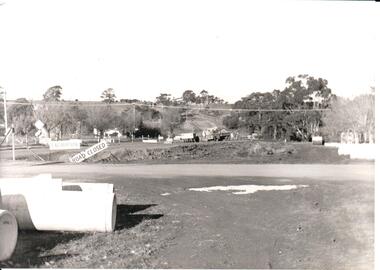
Photograph, Early 1970s
... jacksons creek road construction george evans collection A black ...The two arch bluestone bridge which spanned the Jacksons Creek was replaced in the early 1970s with a wider double lane bridge. Dangerous curves were also taken out of the road. The area in the foreground on the RHS has now been incorporated into a public picnic area.A black and white photograph of road works taking place on the Sunbury Road over Jacksons Creek. Large concrete drain pipes are in the foreground and on the RHS of the photograph with roadwork signs on the LHS. Three trucks are at the foot of the hill.macedon street, macedon street road bridge, jacksons creek, road construction, george evans collection -
 Hume City Civic Collection
Photograph, 1980s
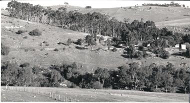
This photograph was taken from the intersection of Loemans and Sunbury Roads. It overlooks the site of the former Bula Primary School and the hillside where stones were laid and painted to form the words "Bulla". The lettering was possible a project carried out by the pupils at the school.A black and white photograph of a panoramic view overlooking the former Bulla Primary School. The photograph has been taken from the intersection of Loemans and Sunbury Roads.bulla primary school, bulla township, george evans collection -
 Hume City Civic Collection
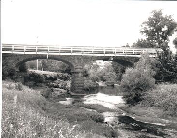
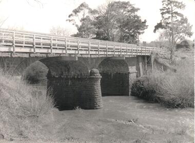
Photograph, Early 1970s
The Macedon Street Bridge over Jacksons Creek is important because it was built on one of Victoria's first important roads. It replaced a smaller lighter bridge in 1857 and continued to be used until the early 1970s.A black and white photograph of a two arched bluestone bridge over a creek. A wooden post and rail fence painted white has been constructed in front of the original stone wall of the bridge.bridges, bluestone bridges, jacksons creek, macedon street, george evans collection