Showing 235 items matching "farm view"
-
 City of Kingston
Photograph - Black and white, 17 January 1951
Moorabbin, Cheltenham and Highett are suburbs in the City of Kingston with a diverse mix of development and zoning. This 1954 image shows the market gardens, farms and paddocks of the Moorabbin and Cheltenham area. which have gradually been sub-divided into The Highett Gas Works is visible and Cheltenham Park and Victoria Golf Club.The suburbs of Cheltenham and Moorabbin were originally developed with extensive market gardens. Over time the district has been transformed with the farms and paddocks replaced by housing, factories and shopping centres. The Highett Gas Works on the Nepean Highway was a significant feature of the landscape and has now been demolished. and the site has undergone remediation.Aerial photograph of Cheltenham, Moorabbin and Highett within the City of Kingston. The area depicted in this 1951 aerial view includes Wickham Road, Highett (bottom right), Keys Road, Moorabbin (bottom left), Centre Dandenong Road Cheltenham (top left), Park Road, Cheltenham (top right), Nepean Highway (left section), Graham Road and Middleton Street, Highett (bottom right). Cheltenham Park and Victoria Golf Club are visible. Nepean Highway and the Frankston railway line run centrally through the image.White type: 1416-37 538 RUN239 LENS 5312" MELBOURNE METROPOLITAN 12150 17-1-51 ↆ M539 Black pencil: N [arrow]cheltenham, highett, highett gas works, market gardens -
![Map, Liquidator's sale, 1896. [Woolpack Estate, Bacchus Marsh]](/media/collectors/5e461d8021ea67224c82f2a1/items/6779ee97032b72846b5995f2/item-media/6779ef33032b72846b599b30/item-fit-380x285.jpg) Bacchus Marsh & District Historical Society
Bacchus Marsh & District Historical SocietyMap, Liquidator's sale, 1896. [Woolpack Estate, Bacchus Marsh]
The Woolpack Estate was an area of land owned by various landowners in the Bacchus Marsh area since the early Colonial period of the 1840s. The area was located on the eastern side of the Bacchus Marsh township about 7 kilometers from the town. The Lerderderg River ran through part of the land and so did the Melbourne to Ballarat Road. The historic Woolpack Inn associated with James Crook was also located on this land. By 1896 150 acres of this land was under the control of liquidators for the Federal Bank of Australasia who instructed that the land be sub-divided and sold in lots by public auction. A successful sale was held on 24 June 1896. Most of the blocks of land were sold for higher than expected prices and most of the buyers were people from the town and district of Bacchus Marsh. The map includes various details about the land which is described on the map as an "important sale of rich alluvial irrigable flat land in the Bacchus Marsh Valley, and other properties". The auction was conducted by the local agents W. Anderson and Bence in conjunction with Pearce Brothers also of Bacchus Marsh.A single page paper map showing a plan of 150 acres of land from the Woolpack Estate to be sold in various lots in June 1896. Also shown on the map are lots for sale at Robinson's Farm on Coimadai Creek and allotments near Bacchus Marsh railway station, including lots on Government Road (East Maddingley Road), View Street and Government Road (Parwan Road). No scale provided. The map is pasted into a bound volume containing 76 maps or plans in total. High resolution digital image stored on BMDHS computer network. land sales bacchus marsh, bacchus marsh victoria maps, woolpack estate bacchus marsh victoria -
 Lakes Entrance Historical Society
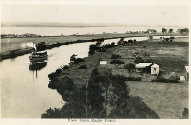
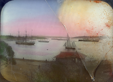
Postcard - Eagle Point, 1930 c
Black and white postcard S S Gippsland in Mitchell River, travelling towards Bairnsdale, silt jetties extending eastwards small farm, farm house and sheds on right. Jones bay in Middle distance beyond silt jetty, taken from Eagle Point Bluff. Bairnsdale VictoriaView from Eagle Point. ships and shipping, waterways, agriculture, houses -
 Lakes Entrance Historical Society
Photograph - Sarsfield Flats, Tambo Shire, 1994 c
Also second identical copyColour photograph of Sarsfield Flats. Distant view of cattle grazing and farm buildings, foothills in background, and glimpse of mountains. Pine trees in the foreground. Bruthen Victoriaagriculture, topography -
 Eltham District Historical Society Inc
Photograph - Digital Photograph, Marguerite Marshall, Eltham Lower Park, 20 April 2008
Originally a race course, the park has brought the community together with a variety of activities. Published: Nillumbik Now and Then / Marguerite Marshall 2008; photographs Alan King with Marguerite Marshall.; p45 Once used for horse racing, which attracted visitors from Melbourne, the Eltham Lower Park has brought the community together with a wide range of activities. Horse riding is now enjoyed as a recreation in the park as are other sports. The park also includes the Diamond Valley Railway miniature trains and a sanctuary for the rare and vulnerable Eltham Copper Butterfly. Eltham Lower Park, with other parks, forms an almost continuous green band from Eltham’s centre, along the Diamond Creek to the Yarra River.1 Before European settlement the Wurundjeri people met on this land, particularly at the junction of the Diamond Creek with the Yarra River, which they called Birr-arung. This is commemorated by the sculpture, Not just a Pretty Place by Aleks Danko, winner of the 2000 Nillumbik Art in Public Places Award. The first European to settle here was probably Henry Foley, who in 1841 used it as part of his pastoral run. Foley sold his leasehold to Joseph Wilson in 1845, who soon after sold it to Frederick Falkiner. During the 1840s the future park was part of a government square mile (2.6 sqkm) reserve, north of the Yarra, within the Parish of Nillumbik, later named Eltham. Soon the land was used for horse racing after nearby residents cleared ten acres (4ha) in the early 1850s. A three-quarter of a mile (1.2km) race secured the winner the £10 Publican’s Prize. In response to popular demand, the newly formed Eltham District Road Board petitioned the Surveyor General of the Colony of Victoria, in 1856, for 36 acres (14.6ha) of crown land for a racecourse and recreation. By 1858 the Eltham races had become an institution. ‘Many skirmishes occurred and the way home was paved with temptation, with sly-grog for sale.3 In the early 1870s, two jockeys were sons of the police officer in charge of the Eltham Police Station, Miles S Lyons. Another ten acres (4ha) was added to the area in 1866 and 12 acres (4.8ha) – Hohnes Hill – in 1870. In 1866, two acres (0.8ha) on the creek banks became an animal pound with William Walsh the pound keeper in 1870, but this was later incorporated into the park. By 1877 the area was called a public park but horse racing and training continued into the 1920s. In the mid-1900s trotters were trained on a circuit road. In 1953 the Eltham Pony Club was established and used a cross-country course on Hohnes Hill. From the mid 1950s the club held the Eltham Easter Fair at the park, later to include a procession along Main Road from the town centre to the park. The park also attracted picnic parties and campers from the inner suburbs as did Wingrove Park, and businesses catering for visitors, sprang up on the opposite side of Main Road. Bus-loads of school children visited the park for Gould League bird days in the 1960s. In 1979 the Eltham Shire Council bought Lenister Farm, linking the park with the Yarra River. The Lenister Farm wetland includes a bird hide, viewing platform and interpretive signs.5 Pioneer Henry Stooke, later Road Board chairman, bought the 11 acres (4.5ha) - later to become Lenister Farm - from the Crown in 1862. Stooke never lived on this site and the two houses at Lenister Farm were built in the 20th century. Since its formation in 1871, the Council has controlled this crown land, which it named Eltham Park. But in the 1920s Eltham Council bought land near the town centre for a park, which it named Eltham Central Park. To avoid confusion the Council renamed Eltham Park, Eltham Lower Park. Since 2004 the Yarra footbridge has linked the park with the Yarra Valley Metropolitan Park and the Main Yarra Trail.This collection of almost 130 photos about places and people within the Shire of Nillumbik, an urban and rural municipality in Melbourne's north, contributes to an understanding of the history of the Shire. Published in 2008 immediately prior to the Black Saturday bushfires of February 7, 2009, it documents sites that were impacted, and in some cases destroyed by the fires. It includes photographs taken especially for the publication, creating a unique time capsule representing the Shire in the early 21st century. It remains the most recent comprehenesive publication devoted to the Shire's history connecting local residents to the past. nillumbik now and then (marshall-king) collection, eltham lower park, eltham park -
 Eltham District Historical Society Inc
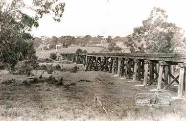
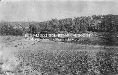
Photograph, Rural view of trestle Bridge, Eltham, c.1912
The railway was commenced in 1900 and passed through the middle of the Shillinglaw farm. The line to Eltham opened in 1902. This view shows the the new Catholic Church, St Mary's in Henry Street (near Main Road, then Maria Street) and Shillinglaw Cottage visible in background past where Eltham Town Park and later the Eltham library (1994) was built. The church site had been relocated from further south along Main Road (near Wingrove Cottage) in order to be more central to the congregation following the shifting of the township away from Little Eltham and closer to the railway station. It was subsequently destroyed by fire in 1961.Black and white photographeltham, trestle bridge, bridges, catholic church, henry street, bridge, shillinglaw cottage, shillinglaw trees, shillinglaw farm -
 Eltham District Historical Society Inc
Photograph - Digital Photograph, Marguerite Marshall, Jelbart home, 93 Arthur Street, Eltham, 11 November 2006
Situated at the top of the hill in Arthur Street, the former Jelbart residence and barn were part of a major change that transformed Eltham's character in the late 1960s. Built from the mid 1940s through mid 1950s when Eltham was a rural community, the Jelbrat residence and barn are all that remain of a family property of some 250 acres (100 ha). With growing population pressures, in the late 1960s, owners Ron and Yvonne Jelbart decided to subdivide their property creating the Woodridge Estate in the early 1970s, a major factor towards the transformation of Eltham to the suburb it is today. The Jelbarts had moved to Eltham in the early 1940s when they purchased a poultry farm in New Street, now Lavendar Park Road. (The local Black Friday bushire of January 13, 1939 had started at C.A. (Clarrie) Hurst’s Eltham Poultry Farm and Hatchery in New Street.) Jelbart was primarily a businessman importing office machinery but desired farm beef and dairy cattle so the couple purchased the virgin bushland at what was then at the end of a dirt road, Arthur Street. With post war shortages of most building materials, they followed the example of the Eltham Artists' Colony (later called Montsalvat) and built thier home from mud-bricks and recyclked materials. The barn was first to be completed in 1945 which they made their home whilst building the main residence. It took eight years to complete the two buildings. Both the main residence and the barn are now separate homes, and along with the remaining property being sub-divided further in 1998 are now part of the Kinloch Gardens Estate at 93 Arthur Street. Covered under Heritage Overlay, Nillumbik Planning Scheme. Published: Nillumbik Now and Then / Marguerite Marshall 2008; photographs Alan King with Marguerite Marshall.; p139 Standing on a hilltop at Arthur Street, Eltham, the Jelbart residence and former barn were part of a major change that transformed Eltham’s character in the late 1960s. Built from the late 1940s to the mid 1950s when Eltham was a rural community, they are all that remain of what was once a family property of around 250 acres (100 ha). As population pressure increased in the late 1960s, owners Ron and Yvonne Jelbart, decided to subdivide their property. The break-up of this property into the Woodridge Estate in the early 1970s, was a major factor towards transforming Eltham into the suburb it is today.1 Although standing only a few minutes from Eltham’s busy hub and hundreds of houses in Woodridge, scarcely any urban sound disturbs the peace. Views from the two buildings are almost exclusively of trees and extend to Mt. Dandenong to the south-east, the Great Divide to the north, and Melbourne city to the south-west. The Jelbarts had lived in Eltham since the early 1940s when they bought a poultry farm in New Street, now Lavender Park Road. Although Jelbart was primarily a businessman importing office machinery, he was keen to farm dairy and beef cattle, so the couple bought rough bushland at what was then the end of Arthur Street. But a shortage of building materials following World War Two hampered their plans to build their new home, so they followed the example of the Eltham Artists’ Colony (later called Montsalvat) and used mud-bricks and recycled materials.2 With great determination the family and friends constructed their house. Massive timber frames and huge quantities of mud-bricks were made on site. The barn was built first in 1945, and two years later, while camping inside, the Jelbarts started building their house. It took eight years to construct the two buildings, even with the help of professional tradesmen. The buildings, with timber frames infilled with mud-brick and plastered, are reminiscent of the English Tudor style. The Jelbarts are of Cornish stock. Much of the timber framework came from demolished bridges or warehouses, and recycled slate was used for roofs and floors. Quality second-hand materials were readily available in the late 1940s and 1950s when there was much demolition in Melbourne and little respect for heritage. A former 19th century Toorak mansion Woorigoleen provided the magnificent stone fireplace, the timber panelling and the parquetry floor in the living room. The large stone gateposts at the entry of the property came from Melbourne University. Almost no mechanical equipment was used to build the 55 square house and the 25 square barn. Massive timber frames were erected using block and tackle pulleys and timbers were shaped, sawn and drilled by hand. Son and architect Ian, with his family, have lived in and extensively renovated both buildings since the early 1970s. Ian transformed the steep ridge of the property into a plateau, where the main house Kinloch stands, surrounded by terraces and lawns. The grounds retain many native plants, including massive yellow boxes – some nudging 80 years. Ian attached 70 metres of pergolas draped with wisteria, roses and grape vines, to three sides of the house. The beautiful garden is featured in the book Through the Rose Arbour by Rosemary Houseman. The two-storey barn – now a house – retains traces of its original use. The cow-shed with milking and feed-rooms, and the machinery-shed remain. The house, separated on the ground floor by a breeze-way, soars two storeys and includes a mezzanine. These are connected by spiral staircases, to timber-beamed and plaster-lined high-pitched ceilings. The house also descends to a wine cellar. Curiously the roof is of corrugated iron on the south and slate on the north, to save costs. Small-paned windows and three French doors open onto the front lawn, which extends to Jelbart Court.This collection of almost 130 photos about places and people within the Shire of Nillumbik, an urban and rural municipality in Melbourne's north, contributes to an understanding of the history of the Shire. Published in 2008 immediately prior to the Black Saturday bushfires of February 7, 2009, it documents sites that were impacted, and in some cases destroyed by the fires. It includes photographs taken especially for the publication, creating a unique time capsule representing the Shire in the early 21st century. It remains the most recent comprehenesive publication devoted to the Shire's history connecting local residents to the past. nillumbik now and then (marshall-king) collection, eltham, arthur street, jelbart barn, jelbart home, kinloch gardens -
 Eltham District Historical Society Inc
Photograph - Digital Photograph, Marguerite Marshall, Smith Dam, Karingal Drive, Eltham, 19 September 2006
The dam at the entrance to the Nerreman Gateway in Eltham was built according to an internationally acclaimed theory developed by the builder's father. In 1920, Victorian engineer B.A. Smith was awarded the American Society of Civil Engineers J. James R. Cross Gold Medal for his Technical Paper titled 'Arched Dams'. It was the first time this medal had been awarded outside the United States. The concrete arched dam across the Eltham West Drain was built in 1940 by B.A. Smith's son and engineer, D. B. (Bernie) Smith to water the 24 acre (9.75 ha) hobby farm owned by himself and new wife, Isa Smith. Upon completion of the dam a pump-house was constructed beside the creek but before the water could be pumped up the hill they had to dig a trench and lay 500m of 100mm water main to an elevated holding tank. The Smiths made the pump-house their home for several years until they constructed their home at the top of the hill overlooking Eltham and views extending to Kinglake. Following Bernie's death in 1983, Nerreman Park was subdivided between 1993 and 1995. Gordon Ford designed the landscaping and the pump-house was demolished. Covered under Heritage Overlay, Nillumbik Planning Scheme. Published: Nillumbik Now and Then / Marguerite Marshall 2008; photographs Alan King with Marguerite Marshall.; p137 The dam at the entrance to the Nerreman Gateway in Eltham, was built according to an internationally acclaimed theory developed by the builder’s father. In 1920, Victorian engineer B A Smith was awarded the American Society of Civil Engineers J. James R. Croes Gold Medal, for his Technical Paper titled Arched Dams. It was the first time this medal had been awarded outside America. An international example of the application of Smith’s work can be found in the design of the Hoover Dam on the Colorado River, Nevada, USA. Built between 1930 and 1936, it is recognised by the ASCE as one of ‘America’s Seven Modern Civil Engineering Wonders’.1 The concrete arched dam across the Eltham West Drain was built by B A Smith’s son and engineer, D B (Bernie) Smith. Bernie’s dam followed his father’s theory, having a curvature that takes maximum advantage of concrete’s great strength in compression. The water load is carried into the abutments because of this curvature, which permits a wall thickness of only 225 millimetres thick at its crest, despite the dam’s capacity of more than 4.5 megalitres. The Eltham dam was designed to water the 24 acre (9.75 ha) hobby farm belonging to newly married couple Bernie and Isa Smith. Bernie, from Armadale, and Isa, from a farm at Tyntynder near Swan Hill, were attracted to the hilly topography and the creek running through the property. It extended from Ryans Road, Eltham, to Karingal Drive, Montmorency and was adjacent to Meruka Park. The Smiths named it Nerreman Park using the Aboriginal word Nerreman meaning ‘River Bend’ as their creek had a pronounced bend.2 In 1940 the first thing Bernie did was to build a dam, and with Isa’s help, a pump-house, to secure a water supply for their cattle, pigs, chickens, orchard and vegetable gardens. It was also available for the fire-plugs, which they placed all over the property in case of bushfire. The couple built the pump-house beside the creek and installed a Tange three-plunger pump, which had originally supplied the City of Wodonga with water. But before the Smiths could pump water up the hill from the dam they had to dig a trench and lay about 550 yards (500m) of a four-inch (100mm) water main up to an elevated holding tank. The trench was dug with a single furrow plough drawn by an old draught horse. Living in rough conditions did not deter the Smiths, who made the pump-house their home, where they still lived when their first child was born in 1944. They later built their home at the top of their property overlooking Eltham, with magnificent views to Kinglake, the Dandenong Ranges and Melbourne. From 1946 it took them almost 20 years to complete the 36-square house with its 12-foot (3.6m) high ceilings. Material for the concrete roof and walls faced with sandstone, was ripped out of the ground on their property by plough pulled by tandem Clydesdale horses. Isa was a strong woman – two days before their second child was born – she set three huge sandstone boulders in place in the bottom wall of the garage. She also mixed all the cement for the house. A collapsed kitchen wall did not discourage her from rebuilding it in a week, while her husband was away working in the country. She later recalled: ‘We stood back to admire this beautiful wall we’d built and while we were looking at it, it came tumbling down’.3 Following Bernie’s death in 1983, Nerreman Park was subdivided, between 1993 and 1995. Local Gordon Ford designed the landscaping and the pump-house was pulled down. But the dam remains as a reminder of exceptional engineering4 – and of a remarkable couple.This collection of almost 130 photos about places and people within the Shire of Nillumbik, an urban and rural municipality in Melbourne's north, contributes to an understanding of the history of the Shire. Published in 2008 immediately prior to the Black Saturday bushfires of February 7, 2009, it documents sites that were impacted, and in some cases destroyed by the fires. It includes photographs taken especially for the publication, creating a unique time capsule representing the Shire in the early 21st century. It remains the most recent comprehenesive publication devoted to the Shire's history connecting local residents to the past. nillumbik now and then (marshall-king) collection, eltham, karingal drive, smiths dam, bernie smith, gordon ford, isa smith, nerreman gateway, nerreman park estate, dams -
 Eltham District Historical Society Inc
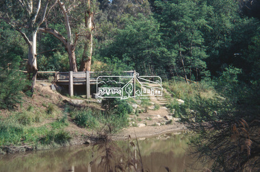
Slide - Photograph, Viewing platform near the confluence of Diamond Creek and Yarra River, c.Nov. 2001
In October 1996 the viewing platform was opened. It is situated near Lenister Farm on the Diamond Creek trail. It was a joint project involving Nillumbik Shire Council, Skill Seekers Inc., Department of Natural resources and Environment and Department of Employment, Education, Training and Youth Affairs. The platform was officially opened by Don Cordell Chairman of Commissioners. Part of a slide show presentation "A Trip Down the Diamond Creek" by Russell Yeoman to the Eltham District Historical Society meeting of 14 Nov. 200135mm colour positive transparency Mount - Black and Whiteconfluence, diamond creek, yarra river, viewing platform -
 Federation University Historical Collection
Photograph - Lantern Slides, Boxed Lantern Slides, c1920
The lantern slides were most probably used at the Ballarat School of Mines. The image of Rome from St Peter's (Vatican) was taken before 1929. The "Via Conciliazione", built by Mussolini in 1929 is not present in the image. Hinged timber box designed to hold glass lantern slides. The box contains 50 lantern slides including: * male Turk in turbin *interior of a cathedral * Cavalry Scene, Boer War (c1900) * Richard Seddon portrait * Fishermen at Sea * Turkish domed building * Eddystone Lighthouse, England * image of early printing * Cloister Court, Trinity College, Cambridge * Farm Cove, Sydney Harbour (by I.F.E) * National Park, Sydney * Customs House, Sydney * View from the Dome of St Peter's, Rome (Pre 1929) * Botanical Gardens, Sydney * Coogee Bay, NSW * Keeble College Chapel, Oxford * Holy Land - The Village of Endor * Sydney Cove * Interior portrait of members of the Victorian Legislative Assembly, Parliament House, Melbourne * Palace Dela Concord, Italylantern slides, entertainment, ballarat school of mines, boer war, richard seddon, sydney harbour, coogee beach, legislative assembly, rome, roma, vatican, vaticono, fairyland, lake wendouree, glass slide, lantern slide -
 Bendigo Military Museum
Map - Panorama sketch from Heath Trench Sector Factory Farm to Messines, 11 April 1917
Panoramic sketch by George W Bleach A 2nd Anzac Topographical Section. April 11th 1917. View from Heath Trench. Co-ords of O.P.U13.b 30.20Panoramic view of Messines. Printed on cream card. Sepia image. By George W Bleach A 2nd Anzac Topographical Section. April 11th 1917. George W Bleach A 2nd Anzac Topographical Section. April 11th 1917.panoramic view of messines -
 Marysville & District Historical Society
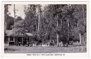
Postcard (Item) - Black and white postcard, Murray Views, MURRAY VIEWS NO. 2. "FRUIT SALAD FARM", MARYSVILLE, VIC, Unknown
A black and white postcard of the Fruit Salad Farm in Marysville that was produced by Murray Views as a souvenir of Marysville.A black and white postcard of the Fruit Salad Farm in Marysville that was produced by Murray Views as a souvenir of Marysville.POST CARD STAMP REAL PHOTOGRAPH PRODUCED IN/ AUSTRALIA BY MURRAY VIEWS, GYMPIE, Q.marysville, victoria, australia, fruit salad farm, accommodation, restaurant, postcard, souvenir, murray views -
 Marysville & District Historical Society
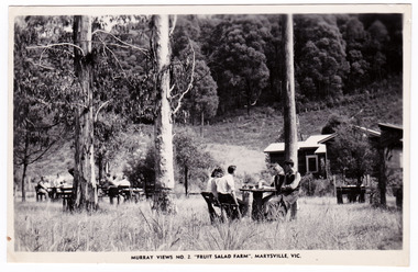
Postcard (Item) - Black and white postcard, Murray Views, MURRAY VIEWS NO. 2. "FRUIT SALAD FARM", MARYSVILLE, VIC, Unknown
A black and white postcard of the Fruit Salad Farm in Marysville that was produced by Murray Views as a souvenir of Marysville.A black and white postcard of the Fruit Salad Farm in Marysville that was produced by Murray Views as a souvenir of Marysville.POST CARD STAMP REAL PHOTOGRAPH PRODUCED IN/ AUSTRALIA BY MURRAY VIEWS, GYMPIE, Q.marysville, victoria, australia, fruit salad farm, accommodation, restaurant, postcard, souvenir, murray views -
 Warrnambool and District Historical Society Inc.
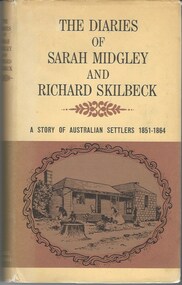
Book, The Diaries of Sarah Midgley and Richard Skilbeck, 1967
Pioneer diaries of early Australian settlers, Sarah Midgley and Richard Skilbeck.Tan hard covered book with tan and yellow dust jacket. Title and text is black. Front cover has framed drawing of cottage taken from photograph which is included in the book. Map of area is on inside front and back covers.208 pages. It has a number of black and white photographic plates included.non-fictionPioneer diaries of early Australian settlers, Sarah Midgley and Richard Skilbeck.sarah midgley, richard skilbeck, diaries of sarah midgley and richard skilbeck, yangery, early pioneer life, wesleyan church warrnambool, yangery koroit -
![Painting: Park Street [Adeney Avenue] Kew](/media/collectors/550653872162f11fb04854aa/items/5826877cd0cdd11284ad5413/item-media/614ac683a53a0756fd5e49da/item-fit-380x285.jpg) Kew Historical Society Inc
Kew Historical Society IncPainting, Park Street [Adeney Avenue] Kew, c. 1896
‘Adeney Avenue’ was the title given to this painting following its donation to the Kew Historical Society, yet the work’s origins predate the naming of Adeney Avenue in 1907 [originally gazetted as ‘Park Street’ (1865) and ‘Park Street South’ (1875).] Park Street ran between High Street and Parkhill Road beside what was later to become ‘Victoria Park’. This area was described in 1851 as “…a dense forest of gums and wattles which were to be largely cleared by 1888 after the naming of a recreation reserve”. The Reserve was still bisected by an unnamed creek in 1896, when the area was surveyed by the MMBW. The panoramic vista selected by the artist would appear to include ‘Eborensis’ (c.1895) on the corner of Parkhill Road and what was then Park Street, with views across cleared land towards the distant ranges. In the 19th century, north Kew was largely undeveloped farms stretching down to the Yarra. Oil on canvas by an unidentified artist of a panoramic view depicting what is now known as East Kew with mountains on the horizon. In the foreground is a two storey brick residence - Eborensis - located on the northeast corner of Parkhill Road and what is now Adeney Avenue. The view of the landscape and its rolling hills resulted from farming practices adopted following colonisation and settlement. Trees in the foreground and in the distance include remnant Eucalypts and introduced exotics.Label on rear of frame states "House on corner of Adeney Ave & Parkhill. [Regd. 254"]. Otherwise unsigned and undatedadeney avenue (kew), eborensis, park street (kew) -
 Wodonga & District Historical Society Inc
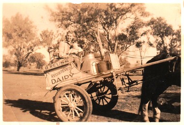
Photograph - Reuss Family Milk Delivery Cart
Joan Reuss was the eldest daughter of Bert Reuss and his wife Grace (nee Gray). Albert (Bert) Reuss was born in Albury in 1905. From 1920 until 1926, Bert worked at Mr Nat Gray’s dairy farm at “ Willow Bank” in South Albury. This included ferrying milk across the river from Gray’s Island. In 1927 he married Grace Gray and they moved to a property which they called “Park View” on the Wodonga flats. Here they established Park View Dairy. In the 1930s they ran two milk carts delivering milk twice a day (once on Sundays) to Albury and Wodonga. They also raised a family of eight children. They progressively cleared a few acres every year and raised cows, pigs and hens as well as growing watermelons and other vegetables. Deliveries extended to include milk, cream, eggs, dressed chickens and potatoes. At its peak the dairy had 500 regular customers. The dairy was bought out by Murray Goulburn in the 1970s and the Reuss children continued the property as a beef farm. Bert was active in the Wodonga Branch of the Dairy Farmers’ Association, President of the Albury Wodonga Milk Producers for 15 years and a member of the Albury Wodonga Flood Committee. He was also Head Steward of the Horticulture Pavilion at the Wodonga Show Society for over 30 years for which he was awarded a Life Membership. Bert Reuss died on 16th August 1998 in Albury. After more then 80 years in the Reuss Family, Park View was sold in 2010.This item is significant because it is connected to a well-known Wodonga business and community member.A black and white photo of a woman and two children on a two wheeled milk cart. On side of cart: B. REUSS REGISTERED DAIRYbert reuss wodonga, wodonga dairies, park view dairy -
City of Kingston
Photograph - Colour, Circa 1993
Edithvale is a suburb in the City of Kingston. It is located between Aspendale and Chelsea on the Port Phillip Bay and built within remnant areas of the Carrum Carrum swamp. The foreshore precinct comprises a wide sandy beach, with low sand dunes and numerous historic boat sheds. The suburb consists of older style dwellings and former holiday houses, combined with mid-century housing and newer homes. The large blocks are increasingly subdivided and the existing dwellings demolished to accommodate units and townhouses, thus changing the landscape of the area and reducing the tree canopy.The beachside suburb of Edithvale was previously part of the extensive Carrum Carrum Swamp. The area was once a source of fish and eels for the Mayone-Bulluk clan of the Bunurong people. Over time the area was drained and predominantly devoted to dairy farming and holiday houses. The farms were gradually sold and subdivided with a large number of homes built after World War II and in the 1960s. Edithvale is mainly residential with a shopping strip along Nepean Highway but little significant industry was ever established in the area apart from a plaster works and confectionary factory, both now closed.Aerial colour photograph of Edithvale as viewed from Alexandra Avenue in the north to Ella Grove Chelsea/Edithvale in the south. The area is built-up with residential housing and facilities including Edithvale Primary School, numerous churches and the Edithvale Railway station. Large sections depict the remnant Carrum Carrum swamp. Edithvale Common and the former "Duck Inn" (Melbourne Water/Friends of Edithvale Seaford Wetlands) can be seen. Edithvale Recreational reserve, the velodrome and Edithvale Public Golf Course are prominent. The image shows vacant land in the area now known as Aspendale Gardens and the newer residential section of Chelsea Heights is not developed. A bike path has been established to cover the secondary drain. The Golf Links Court residential development located off Hughes Avenue is a large vacant block.Yellow circular adhesive sticker on plastic Black ink (marker): * (asterisk) Black type on white adhesive sticker: P000108edithvale, aspendale, chelsea, carrum carrum swamp -
 Eltham District Historical Society Inc
Audio - Audio Recording, EDHS after 50 years, 11 Oct 2017
Audio Recording of 11 October 2017 Society meeting. Description from Newsletter No. 236, Oct. 2017 : A 50th Anniversary Panel of EDHS Members As this meeting is close to the 50th anniversary of the first meeting of the Shire of Eltham Historical Society, on 24th October 1967, we will appropriately look back on our own history. This will include a panel of members who will highlight some of our experiences and achievements along the way. As a special 50th anniversary treat we will have the opportunity to view, for the first time, a video reflecting on the first 50 years of our Society. This video, produced by Gerald Ashcroft from www.storiestobetold.com.au, is based around interviews with Russell Yeoman and Doug Orford about their recollections. The first speaker is meeting MC Jim Connor, EDHS President who gives a report on current EDHS bussiness and past and upcoming events of interest. The second speaker is Secretary Russell Yeoman. Topics include new panel artworks "Our Eltham Artisitic Recollections" at Eltham Cemetery and Shillinglaw farm walk and other business. The history presentation starts about 15 minutes into the recording. 1:24:45 duration Digital MP3 File 30 MB society meeting, 50th anniversary, audio recording, meeting, eltham district historical society, jim connor, russell yeoman, our eltham artistic recollections, doug orford -
 Eltham District Historical Society Inc
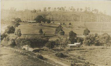
Photograph, Trestle Bridge, Eltham, c.1910
Most likely an F-Class 2-4-0 Steam Locomotive pushing carriage about to cross the Eltham Railway Trestle Bridge heading towards Greensborough, viewed from what was later Eltham Common and site of the re-located Shillinglaw Cottage (1964) and Eltham Library (1994). On the far side of the track on what is present day Central Park oval is a crop field. The railway was commenced in 1900 and passed through the middle of the Shillinglaw Farm. Here it passes through the farm paddocks. The train station at Eltham opened in 1902. Colour photocopy of original photo print (on loan?) 25.5 x 39 cm mounted on coreflutePencil mark at bottom "(c) 1910"eltham, trestle bridge, bridges, shillinglaw farm, f-class 2-4-0 steam locomotive, eltham railway trestle bridge, eltham trestle bridge, railway bridge, steam locomotive -
 Lakes Entrance Historical Society
Postcard - Tambo Upper
Also another black and white photograph of same scene different angle crop of maize shown, boat on river possibly PS TanjilSepia toned photograph of view across the Tambo River looking eastward from Stephensons Road corner of Riversdale farm on right Redenback House in distance Swan Reach to Bruthen road shown with rinbarked trees on hill Tambo Upper Victoriaagriculture, settlement -
 Lakes Entrance Historical Society
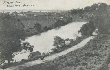
Postcard - Eagle Point bluff, silt Jetties and Jones' Bay, Eagle Point Victoria, A W Burman Bairnsdale, 1912 c
Letter on back dated Dec 30 1912 to Mrs Brewer Signed FloraBlack and white postcard showing view of Mitchell River looking east towards Eagle Point bluff and the silt Jetties and Jones' Bay small farm and buildings, hop kiln on bank opposite bluff and hop paddock. Horse and jinker on gravel road Eagle Point VictoriaMitchell River Eagle Point Bairnsdale waterways, rivers, jetties, roads and streets, transport -
 Lakes Entrance Historical Society
Album, LERHS members, Lakes Entrance Historical Society Day Trips, 2006
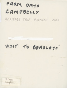
Photograph album containing photographs taken during Lakes Entrance Historical Society members visit to Campbells farm Lakes Entrance, Buchan and Beasleys home Lindenow Victoria. Please visit History Centre to view all photos in this Album. celebrations, township -
 University of Melbourne, Burnley Campus Archives
Photograph - Colour print, Aerial View of Countryside, Unknown
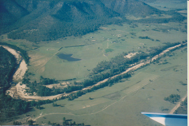
... countryside aerial views river valley farm buildings dams ...4 colour photographs taken from a small aeroplane. Views of countryside, river, valley, mountains, dams, farm buildings countryside, aerial views, river, valley, farm buildings, dams, mountains -
University of Melbourne, Burnley Campus Archives
Photograph - Colour print, Kodak, Excursion, Unknown
13 colour photographs taken possibly on an excursion. Views of the countryside, river, valley mountains, dams, farm buildings.excursion, countryside, river, valley, mountains, dams, farm buildings -
 National Wool Museum
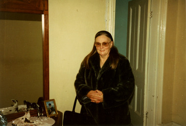
Photograph - Theresa Joy Hodge Wearing Fox Fur Coat, 1995
This photograph shows Theresa Joy Hodge wearing the fox fur coat her father made, which is now part of the National Wool Museum Collection, NWM-9090. "The foxes were shot in the 1950's by my Father, Charles Winnet Daniel Allen at two properties around Bacchus Marsh. One was Greystones at Glenmore, owned by the O'Keith family and the other was at Parwan, owned by the Miles Family. In the late 1940's and early 1950's, the Government put a bounty on the fox head. A pair of ears were sent to the Council and you were paid 2 pennies and the skins were sold to a skin buyer. My Father would go out on moon lit nights and shoot the foxes then skin them, which he would peg on a board to dry. He took 21 fox skins to Nettlebergs Pty. Ltd., Furriers at 173 Elizabeth Street Melbourne, Victoria, to have this coat made for my Mother, Gladys Eileen Allen. It cost Twenty Pound and Nine Shillings to have the skins made into this coat. My Father died on the 1st July 1982 and my Mother on the 15th October 1993, aged 76. This coat was inherited by me Theresa Joy Hodge (nee Allen) on the passing of my Mother. I have worn it on cold days, but seeing that I am 84 and the coat is 74 years old, I would like to donate it to you, as I have no-one to leave it to and hope that you and the visitors to your Museum will enjoy looking at it." Theresa Hodge, 2025 Theresa was a dairy farmer, who grew up in Bacchus Marsh with her parents, before moving to South Australia in 1980 to a 167 acre farm in Burrungale.Colour photograph showing an interior view of a woman wearing sunglasses and a fox fur coat. She is standing in front of a doorway, and beside a dresser which has a mirror, ornaments and a photograph.back: [handwritten] 1995 Winter / Theresa Allen back: [printed] Kodak / Official Sponsor / of the / Olympic Gamesfox fur coat, fashion, hunting, pest eradication, farming, rural life, bacchus marsh, greystones, glenmore, parwan, fox, nettlebergs pty ltd, furriers, clothing, theresa hodge, charles allen, gladys allen