Showing 316 items matching "farming history"
-
 Tatura Irrigation & Wartime Camps Museum
Book, The Italian Farming Soldiers, 1981
Written to show role of Italian POW's as labour on farms from 1941-1947Red hard cover. Map of Australiain green, white and red. italian POW's and camp scene and Italian farmers.italian pow's, books, history, local, reference -
Tatura Irrigation & Wartime Camps Museum
Book, Achievement Report, 2000/2001
Information from NRE Irrigation Region in Mildura and Irymple, Swan Hill, Kerang, Pytramid Hill, Echuca, Kyabram Dairy Centre, Tatura and CobramBlue cover, 4 small panels depicting scenes of water-farming-fruitgrowingirrigaton, books, history, local, rural -
Tatura Irrigation & Wartime Camps Museum
Booklet, Cosgrove District
... History of Cosgrove District farming community for Back... Tatura the-murray History of Cosgrove District farming community ...History of Cosgrove District farming community for Back-to-Celebrations. Includes a poem by Greg Maher and newspaper article on W "Digger" James.Cream cover. Entrance sign and silos in background on front cover.cosgrove, cosgrove district, farming in cosgrove, cosgrove back to back celebrations, greg maher, w "digger" james -
Lakes Entrance Historical Society
Memorabilia, Early Farming Scenes of East Gippsland, 1985
Calendar issued as part of Victorian 150th Anniversary celebrations1986 Calendar, beige coloured plastic cover with white spiral bound plastic spine, photo on front cover is of Bullock Team carting a wagon with wool balesdocuments, calendars -
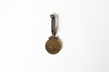 Chiltern Athenaeum Trust
Medal
This medal from the estate of W.C. Busse is believed to have been awarded to a recipient at the Rutherglen Agricultural Show in 1885. Due to degradation of the embossed markings, it is uncertain what the medal was awarded for or whom it was awarded to. It may have been awarded to a member of the Busse family prior to W.C. Busse's birth. Rutherglen is located approximately 18 kilometres from Chiltern. European agriculture and horticulture in the area was well established prior to the discovery of gold in the region in the 1860s. It held its first yearly Agricultural Show in 1880; in the present day it has a sister event focusing on showcasing the region's wines. Wilfred Clarence Busse was born in Chiltern in 1898. He went to school at Wesley College in Melbourne, studied law at the University of Melbourne and became a barrister. Additionally, after spending time on a Victorian station in his early twenties, he wrote two historical novels about bush life. His first novel was 'The Blue Beyond: a Romance of the Early Days in South Eastern Australia', written in 1928 and published in 1930. Busse's second novel was titled 'The Golden Plague: A Romance of the Early Fifties'. The judges of the Henry Lawson Society's T.E. Rofe competition to advance Australian literature unanimously awarded it the Gold Medal in 1931 for the best historical novel of 1930. Newspaper articles about the award mention the writer's meticulous documentary and oral history research regarding life on the Gold Fields in the 1850s. It became a best-seller. Busse also wrote a series of articles about local history for "The Federal Standard" newspaper in Chiltern. He was a member of the Chiltern Athenaeum. He died in 1960. This item is significant for the information it provides about the development of industry and local culture in Victoria in the 1880s. Bronze coloured medal attached to single large-format chain link; embossed medal markings are indistinct but appear to show Coat of Arms on reverse side. Inscription on obverse: Illegible Indistinct inscription on reverse may read: Rutherglen Agricultural Society medal, rutherglen agricultural show, chiltern, north-east victoria, gold fields, gold mining, gold rush, 1885, heirloom, farming, horticulture, rutherglen historical society, indigo shire, wilfred clarence busse, golden plague, authors, writers, victorian writers, victorian literature, historical fiction, blue beyond, wesley college, federal standard -
Clunes Museum
Equipment - MILK CAN
... IN LOCAL FARMING DISTRICT LOCAL HISTORY DOMESTIC ITEM CONTAINERS ...USED IN LOCAL FARMING DISTRICTMILK CAN FOR COLLECTION OF MILKlocal history, domestic item, containers, harris william -
 Wangaratta Art Gallery
Sculpture, Mandy Gunn, Fire Sticks, 2009
Gunn’s work explores political and social values through the mediums she uses and the inspiration she draws upon. In 'Fire Sticks', Gunn uses recycled material as an explorational response to throw away culture, while the design draws inspiration from the sticks used in firestick farming and the charred remains of flora after a fire, which highlights the history and place of fire in Australia.Wangaratta Art Gallery Collection. Winner of the 2009 Wangaratta Contemporary Textile Award.This artwork was sculpted out of recycled inner tubes woven together with cotton thread on wooden poles.wangaratta art gallery, mandy gunn, sculpture, textile, wcta -
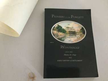 Wonthaggi & District Historical Society
Book and Map, Barbara Moyle, Pioneers on tthe Powlett and at Wonthaggi 1878-1910, 2015
... features Farming and social history of pioneers of the Powlett ...Book - families social histories, maps, photograps Map - block numbers town names physical / geographical featuresFarming and social history of pioneers of the Powlett River are prior to the establishment of the State Coal Mine at Wonthaggi. Significant land marks, buildings and photographs are included. Dark green cover with oval artists impression of Powlett river and bridge Associated map which covers the parishes plus key places of interestlPioneers on the Powlett and at Wonthaggi 1878-1910 Barbara R Moyle 2015 Early History of Settlement Map - Parish names, significant sitesfarming, pioneers of wonthaggi and district, wonthaggi families -
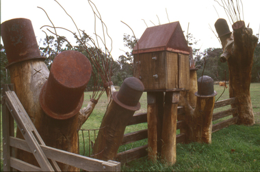 Nillumbik Shire Council
Sculpture: Tony Trembath (b.1946 Sale, Victoria), Tony Trembath, The Fences Act 1968 - Location: Edendale Farm (entrance) 30 Gastons Road, Eltham, 1989 - 1994
Eltham Council (now the Shire of Nillumbik) commissioned this work in 1989 to create an entrance / gateway to Edendale Community Farm. It was also aided by a grant from the Ministry of the Arts (now Arts Victoria). The former name of this work was "Gateway to Edendale Farm". Edendale Farm is a demonstration farm modelling sustainable environmental practices, providing support to the local residents of Nillumbik. Established in 1986, the land was purchased in 1970. It was previously an English gentleman's residence and was used for grazing. It consists of 5.6 hectares, with the Diamond Creek meandering through the property. The Victorian Fences Act 1968 governs liability of occupiers of adjoining lands to fence, and deals with disputes between neighbours regarding boundaries fences and costs. This work took into consideration ideas and suggestions from residents and committees, who required the use of recycled materials and that the work celebrate man's relationship with nature, animals and the earth, as well as relate to the fence-line on the far side of the carpark. Trembath also absorbed significant aspects of local history, making references to Eltham's agricultural past, the clearing of the land, the destruction of trees, the ruthless pruning of trees by suburban Councils and incorporated such Australian features as the post and rail fence. 'The Fences Act 1968' is significant for aesthetic, historic and social reasons at a regional level. It makes prominent the historical and social significance of Edendale and the rural aspects of Nillumbik. The use of existing tree stumps and salt pots in the work explores the iconography of the countryside such as the isolated farmhouse, pioneering farming practices, post and rail fencing and the regrowth of lopped trees. The title of the work, as well as the extensive community involvement in its creation, also makes reference to the Victorian Fences Act 1968, which makes neighbours jointly responsible for the cost of construction and maintenance of fences in the partitioning of land for settlement. 'The Fences Act 1968' has been classified as of regional significance by the National Trust of Australia. The work is an installation of wood and metal, approximately twenty five meters long. The design is very informal and rustic and runs the full width of the fence-line. It comprises groups of recycled tree trunks fitted with metal caps (chrome-nickel 'salt pots' that are shaped like tall bowler / top hats). Metal rods protrude from the trunks and some of these rods have metal birds. Two larger, sentinel-like stumps at the two outer ends have metal flame-like wings, which bend inward. To the left of the entrance, a simple architectural element indicates an isolated farmhouse. The rustic fence runs between the groups of tree trunks with native planting in clumps along it. The fence-line incorporates a functional engineered double gate and post and rail fencing. There may be many interpretations of the work and the intention is to stimulate interest and imagination rather than alienate. Interpretation is based on the personal experience that a visitor brings. The artist recommended that no explanation of the design logic be positioned with the work. N/Apublic art, sculpture, edendale, recycled, wood, metal, fences act 1968, gate, trembath, salt pot, tree stumps -
Koorie Heritage Trust
Book, Butlin, Noel George, Our original aggression : Aboriginal populations of southeastern Australia, 1788-1850, 1983
Contents: Introduction and Disease Background - Black fellow fall down, jump up white man; Death at a long distance. Demographic Modelling - Assumptions and procedures - Basis of modelling; Depopulating disturbances - Diseases and population recovery - Smallpox; the potential for population recovery; Other diseases; Summary diseases effects - Resource competition - Resource depletion and depopulation; Black and white options. Appraisal of estimates - '1788' population possibilities; Possible extrapolations; Summary results. Towards an Ecological Model - Economy and ecology; Some general inferences.xii, 186 p. : ill. ; 22 cm.Contents: Introduction and Disease Background - Black fellow fall down, jump up white man; Death at a long distance. Demographic Modelling - Assumptions and procedures - Basis of modelling; Depopulating disturbances - Diseases and population recovery - Smallpox; the potential for population recovery; Other diseases; Summary diseases effects - Resource competition - Resource depletion and depopulation; Black and white options. Appraisal of estimates - '1788' population possibilities; Possible extrapolations; Summary results. Towards an Ecological Model - Economy and ecology; Some general inferences.aborigines, australian -- population. | aborigines, australian -- statistics, vital. | aborigines, australian -- treatment. | europeans -- australia. | australia -- history -- 1788-1851. | fire-stick farming -
 National Wool Museum
Tool - Shearing Handpiece, c.1890
... has a long history which includes wool farming. Wellington..., the property has a long history which includes wool farming. Wellington ...Ford and McFarlane shearing handpiece c.1890. This shearing handpiece is from ‘Wellington Lodge” in Tailem Bend, South Australia. Wellington Lodge today is an Angus beef farm; however, the property has a long history which includes wool farming. Wellington Lodge has been in the McFarlane family since the 1840’s and was originally around 19000 acres. The donor, Brian Licence, assembled this handpiece out of spare parts he found while classing wool on the property in the 1960s. Brian showed the finished handpiece to the owners once his classing work was completed and was told he could keep the handpiece as a souvenir. Brian also classed wool at “Jockwar” and “Pleasant Park” in Penola for members of the McFarlane family during the 1960s. The handpiece is named after Ford, the name of the engineer who designed the handpiece and McFarlane, the owners of Wellington Lodge Station and employers of Ford. This handpiece was developed as a prototype for use on the property. The handpiece which is made of solid brass is in a “used condition” and has been patched with solder. The handpiece is stamped with the number 10. Internally, the handpiece is powered from a drive mechanism of compressed air, this compressed air was typically produced by burning mutton fat. The handpiece comes from the pre-electrical– steam engine era of shearing. Brass metal shearing handpiece. A three-pronged fitting to hold both the comb and the blade protrudes from one end. A cylindrical stem extends vertically from the other. This is likely where a connecting rod to the shearing plant would be found. Below this vertical stem, the handpiece has an additional threaded hose fitting. This is likely where compressed air was delivered into the handpiece. The inscriptions can be found on the rear, near the previously mentioned vertical stem. Around this stem is also where the repairs of solder can be found. These repairs are unique to this handpiece and are not common practise.Etched. Base of handle. “FORD & McFARLANE . SHEEP SHEARER . Etched. Base of handle. “10”sheep shearing, shearing equipment, ford & mcfarlane, wellington lodge, tailem bend, south australia, shearing handpiece, shearing -
Whitehorse Historical Society Inc.
Document, Daniel Harvey:The father of power farming in Australia, 1995
The history of Daniel Harvey and his manufacturing of agricultural power machinery. 1876 - 1960.The history of Daniel Harvey and his manufacturing of agricultural power machinery. 1876 - 1960.The history of Daniel Harvey and his manufacturing of agricultural power machinery. 1876 - 1960.agricultural machinery, daniel harvey, finger, stan -
Whitehorse Historical Society Inc.
Article, Tally Ho Really Cares, 1972
Tally Ho Boys Home cares for 96 boys between 11-16 years.Tally Ho Boys Home cares for 96 boys between 11-16 years. Most boys are young offenders. The boys are housed in 8 cottages, 14 teachers look after their education, they also learn farming skills and have ample sports opportunities. Rev. Dennis Oakley, Head of Tally Ho, advertises for Hannams Stores. He uses the money to realise long term plans for Tally Ho. The article also covers the history of Tally Ho.Tally Ho Boys Home cares for 96 boys between 11-16 years. youth services, tally ho boys home, methodist mission, oakley, dennis, rev., edwards, john -
Whitehorse Historical Society Inc.
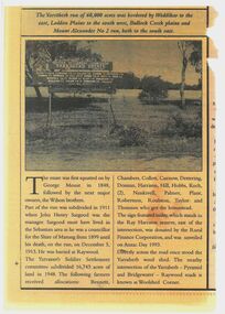
Map, City of Nunawading Historical Geography Project
Periods covered 1834-1879. Early colonists to coming of railway, 1880-1918 Land boom, bust to WW1, 1919-1944 Part WW1 to end of WW2, 1945-present Post war suburban explosion - farming, clay industries,settlement.local history, heritage awareness study steering commitee, johnston chris, walker, vanessa, vosper, maria, kellaway, carlotta -
 Whitehorse Historical Society Inc.
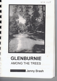
Book, Glenburnie among the trees, 1997
History of Glenburnie Road, VermontHistory of Glenburnie Road, Vermont prepared by Jenny Brash, 1997. Includes a brief history of Vermont with maps of the area. Mentioned are gold mining, orchards, farming and the tile factories. Visits by gypsies. The flora of the area. The establishment of Bloom Reserve and Hales Park, the Kirkpatrick Homes and the Vermont Elderley People's Homes. People mentioned include Paton 1940-53, Hamilton ca 1935, Brereton ca 1937-70, Tovey ca 1930-60, Rawson 1943-, Palmer 1937-, Ken Hauser 1956-, Kirkpatrick 1924-68, Hale 1946-, Esme White, Tom and Pat Fagetter, Francis Hall 1924-, Leonard Uren 1922- (Farley Green Estate). 33 pages, photographs, maps.History of Glenburnie Road, Vermont glenburnie road, vermont, brash, jenny, bloom reserve, hales park, native plants -
 Ballarat Heritage Services
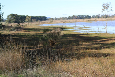
Photograph - Digital photograph, Dorothy Wickham, Winter's Swamp, Ballarat, January to April 2014
Study of Winter's Swamp commissioned by BEN and completed by BHS. The swamp was named after one of the first European settlers in the district. Winter Swamp LAT -37 32 LONG 143 47, Parish of Dowling Forest, County of Grenville Winter Swamp, on the southwest corner of Ballarat West Town Common, was not included in the original proclamation of the Common in 1861. However, being marshland, it was not considered suitable for grazing, so was added to the Common soon after 1861. Winter Swamp is a large wetland with native and exotic pasture significant for wildlife. John Winter (Jock) was born in Berwickshire, Scotland. He married Janet Margaret Irving the daughter of Robert Irving, advocate, Bonshaw, Dumfries, Scotland. Winter died in Ballarat in 1875 and was buried at the Ballaarat Old Cemetery. He took up the run Bonshaw from 1841; Leigh River Buninyong 1842-46; Junction, Delatite, March 1851 to September 1862; with sons: Carag Carag and Corop, April 1857 to September 1872; Colbinabbin and Stewart’s Plains, April 1857 to December 1872; St Germains February 1867 to March 1871. (The name became Winter-Irving in 1890). Mr John Winter, who died on August 22 at the age of 72, was a man of some note it the mining community of Ballarat. He was a self-made man, and one of our oldest colonists, it being over a quarter of a century age since he took up county about Ballarat and settled at Bonshaw. He died very rich. It is calculated that if he had retained an interest in all his runs, his income must have been not less than £10,000 or £50,000 a year. Some eight or ten years ago he sold his Bonshaw pre-emption to the Bonshaw Gold mining Company for £20,000, and a few years later the ground belonging now to Winter's Freehold Company brought him £50,000 more, the payment being made at the requisition of the deceased in sovereigns. In these relations Mr. Winter has been closely identified with the mining industry at Ballarat. The deceased was a native of Lauder, in Berwickshire, and landed in Victoria several years before the gold discovery.The principle task of this project was the delivery of a report outlining the history of European settlement in the Skipton and Cardigan/Ballarat districts as pertinent to the use of and impact on the natural environment of the two reserves Skipton Common and Winter Swamp. The report was delivered in digital form only. The report, upon completion, was presented to the Network’s Committee in order to discuss the project. The report identified and described the uses of Skipton Common and Winter Swamp, and their impacts. In particular, this report examined farming/grazing (official and informal), mining, vegetation removal (including the removal of woodlands for timber, grasslands for pasture improvement) & use of riparian areas for access to water and timber removal. Recording the more benign and environmentally friendly uses such as picnicking, community activities, nature walks and the roles of organisations such as Field Naturalists’ and Bird Observers’ clubs, school and scout/guide groups will be relevant in helping to depict overall community attitudes towards the reserves; e.g.: has the Common generally been viewed as little more than a grazing paddock and fire hazard; has Winter Swamp always been the unknown natural asset that seems to have been its lot for at least the past 40 years? In this regard, the more contemporary history of actions surrounding the use and management of the reserves is of particular interest, in view of the extant evidence at both reserves; e.g. the actions of the Shire of Ballarat in the 1980s in establishing Winter Swamp as something of a competitor to Lake Wendouree but with a more environmental bent (although almost none of the plants used are indigenous species, but that is part of the story); the trotting track constructed on Skipton Common in the 1960s following representations to Premier Henry Bolte and the cropping of the western section of the Common to raise funds for the town’s new swimming pool, the fertilizing of the land putting an end to the native grassland vegetation. There are obviously multiple sources of information to source in preparing the report, however sources that the contractor is specifically requested to consult are the Skipton Historical Society, the former Skipton Common managers (specifically Graeme Pett), the Cardigan Windermere Landcare Group and the Learmonth Historical Society (believed to hold many of the former Shire of Ballarat’s records pertaining to the Council’s role as the Committee of Management for both Winter Swamp and the Ballarat West Town Common – Winter Swamp was split between 2 separate Crown Land tenures). The contractor is also encouraged but not required to utilise community newsletters, such as the Skipton Community Newsletter, to publicise and seek information about the project. Skipton Historical Society (Mary Bradshaw) contacted on Thursday 12 June 2.30pm. Mary lived on a farm out of Skipton but is currently living in the township. She remembers walking along the creek of the Common especially in spring and autumn in bare feet and that it was a very pretty place. There were a few snakes around the waterway in summer. People put cows and a couple of horses on the commonage to graze. Graeme Pett has always lived close to the Common and would know a lot about it. Other possible contacts would be Nicole Petress, Secretary of the Progress Association, and the Corangamite Council, Camperdown. Digital images of Winter's Swampwinter's swamp, ballarat, john winter, ballarat environmental network, mullawullah -
 Ballarat Heritage Services
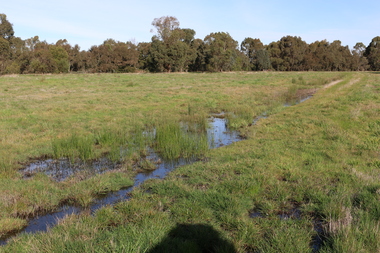
Photograph - Digital photograph, Winter's Swamp surrounds, April 2014
The swamp was named after John (Jock) Winter. John Winter (Jock) was born in Berwickshire, Scotland. He married Janet Margaret Irving the daughter of Robert Irving, advocate, Bonshaw, Dumfries, Scotland. Winter died in Ballarat in 1875 and was buried at the Ballaarat Old Cemetery. He took up the run Bonshaw from 1841; Leigh River Buninyong 1842-46; Junction, Delatite, March 1851 to September 1862; with sons: Carag Carag and Corop, April 1857 to September 1872; Colbinabbin and Stewart’s Plains, April 1857 to December 1872; St Germains February 1867 to March 1871. (The name became Winter-Irving in 1890). Mr John Winter, who died on August 22 at the age of 72, was a man of some note it the mining community of Ballarat. He was a self-made man, and one of our oldest colonists, it being over a quarter of a century age since he took up county about Ballarat and settled at Bonshaw. He died very rich. It is calculated that if he had retained an interest in all his runs, his income must have been not less than £10,000 or £50,000 a year. Some eight or ten years ago he sold his Bonshaw pre-emption to the Bonshaw Gold mining Company for £20,000, and a few years later the ground belonging now to Winter's Freehold Company brought him £50,000 more, the payment being made at the requisition of the deceased in sovereigns. In these relations Mr. Winter has been closely identified with the mining industry at Ballarat. The deceased was a native of Lauder, in Berwickshire, and landed in Victoria several years before the gold discovery. BHS were commissioned by Ballarat Environment Network for a project on Winter's Swamp and Skipton Common. Winter's Swamp was part of Ballarat West Common. The principle task of this project was the delivery of a report outlining the history of European settlement in the Skipton and Cardigan/Ballarat districts as pertinent to the use of and impact on the natural environment of the two reserves Skipton Common and Winter Swamp. The report was delivered in digital form only. The report, upon completion, was presented to the Network’s Committee in order to discuss the project. The report identified and described the uses of Skipton Common and Winter Swamp, and their impacts. In particular, this report examined farming/grazing (official and informal), mining, vegetation removal (including the removal of woodlands for timber, grasslands for pasture improvement) & use of riparian areas for access to water and timber removal. Recording the more benign and environmentally friendly uses such as picnicking, community activities, nature walks and the roles of organisations such as Field Naturalists’ and Bird Observers’ clubs, school and scout/guide groups will be relevant in helping to depict overall community attitudes towards the reserves; e.g.: has the Common generally been viewed as little more than a grazing paddock and fire hazard; has Winter Swamp always been the unknown natural asset that seems to have been its lot for at least the past 40 years? In this regard, the more contemporary history of actions surrounding the use and management of the reserves is of particular interest, in view of the extant evidence at both reserves; e.g. the actions of the Shire of Ballarat in the 1980s in establishing Winter Swamp as something of a competitor to Lake Wendouree but with a more environmental bent (although almost none of the plants used are indigenous species, but that is part of the story); the trotting track constructed on Skipton Common in the 1960s following representations to Premier Henry Bolte and the cropping of the western section of the Common to raise funds for the town’s new swimming pool, the fertilizing of the land putting an end to the native grassland vegetation. There are obviously multiple sources of information to source in preparing the report, however sources that the contractor is specifically requested to consult are the Skipton Historical Society, the former Skipton Common managers (specifically Graeme Pett), the Cardigan Windermere Landcare Group and the Learmonth Historical Society (believed to hold many of the former Shire of Ballarat’s records pertaining to the Council’s role as the Committee of Management for both Winter Swamp and the Ballarat West Town Common – Winter Swamp was split between 2 separate Crown Land tenures). The contractor is also encouraged but not required to utilise community newsletters, such as the Skipton Community Newsletter, to publicise and seek information about the project. Skipton Historical Society (Mary Bradshaw) contacted on Thursday 12 June 2.30pm. Mary lived on a farm out of Skipton but is currently living in the township. She remembers walking along the creek of the Common especially in spring and autumn in bare feet and that it was a very pretty place. There were a few snakes around the waterway in summer. People put cows and a couple of horses on the commonage to graze. Graeme Pett has always lived close to the Common and would know a lot about it. Other possible contacts would be Nicole Petress, Secretary of the Progress Association, and the Corangamite Council, Camperdown. Mary can’t remember any photos in the Skipton Historical Society that pertain to the Common. Digital photos of Winter's swamp surrounds, later known as Mullawullah.winter, winter's swamp surrounds, winter's swap, john winter, ballarat environmental network, ballarat, mullawullah -
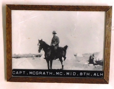 8th/13th Victorian Mounted Rifles Regimental Collection
Photograph - McGrath, 1918 circa
William 'Lauchie' McGrath, an accountant with Australian Mercantile Land & Finance (AML&F), enlisted in AIF in September 1914. He was posted to 8th Light Horse regiment with the No 268 and rank of trooper. He rose through the ranks, serving at Gallipoli, Egypt and Palestine reachin the rank of Captain/Adjutant of the regiment. The 8th Light Horse Regiment AIF was raised at Broadmeadows Victoria in September 1914 under the command of Lieutenant Colonel Alexander White and formed part of the 3rd Light Horse Brigade. The regiment served at Gallipoli where in a courageous but ill-fated charge at the Nek on 7 August 1915 it suffered horrendous casualties including Lieutenant Colonel White. Rebuilt in Egypt under the command of Lieutenant Colonel Leslie Maygar VC the regiment went on the serve throughout the Middle East Campaign. Colonel Maygar died of wounds at Beersheba when the regiment was attacked by enemy aircraft while waiting to follow up the successful charge of the 4th LH Brigade on 30 October 1917. The 8th Light Horse AIF was disbanded in 1919, but soon after re-raised as the 8th (Indi) Light Horse in the Citizen Military Forces, superseding 16th (Indi) Light Horse. McGrath wrote the History of the regiment (See 3091.901) Following his return to Australia he took up farming in the Upper Murray, On 10 February 1924, a community picnic was being held at a creek below his Jingellic homestead when a maniac armed with a rifle came out of the scrub and proceeded to shoot indiscriminately int the party. No reason was ever given but it was presumed that he wanted to kill one man who was not among the five he hit. McGrath got the women and children into the creek and organised the other wounded - he had already been hit in the chest - into cover before running over open ground for his rifle in the house. In all he stopped five bullets but the gunman bolted once McGrath appeared with his own weapon.Some weeks later he was captured getting milk from a dairy and declared insane. One of the five victims died that day, one some months later, one had to use a stick for the rest of his life and McGrath was forced to give up the farm and return to his old job as an accountant. He was awarded the silver medal of the Royal Humane Society of NSW and the silver medal of the Royal Shipwreck Relief & Humane Society of NSW. The latter body felt the water in the creek made it appropriate to also make the award. McGrath enlisted again in World War Two, serving firstly as 2/ic Broadmeadows Camp and later 2/ic the Officer Commanding 12th Garrison Battalion. Framed black and white photograph of mounted officer with tents in background.Across lower edge of frame "Capt. McGrath. MC.. MID. 8th Australian Light Horse"mcgrath, 8th, light horse, garrison, royal humane society nsw -
 Otway Districts Historical Society
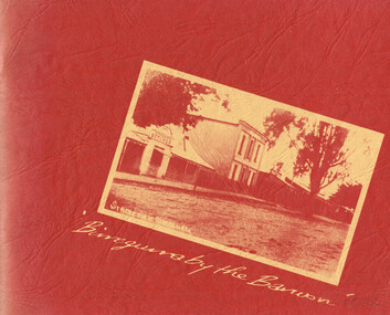
Book, Birregurra Hall Committee, Birregurra by the Barwon
A history of Birregurra from the first settlement of Bunting Dale Mission Station in 1839 to the present.Birregurra by the Barwon. Fiona Henderson (ed.). 1st ed. Birregurra Hall Committee; Birregurra (Vic); nd. i, 60 p.; illus, maps. Soft cover.birregurra; barwon river; history; bunting dale; bowens point; farming; explorers; settlers; -
 Bendigo Historical Society Inc.
Newspaper - Newspaper articles - North Central Loddon Region
8375a: The Victorian soldier settlement scheme created in 1917 to lease farming land to soldiers and nurses returning from WW1. The Scheme was heavily criticised. Some reasons for this were the settlers' lack of capital, the size of the land allocated, and the prices of agricultural products both purchased and sold by the farmers. In the wake of WW2, the soldier settlement scheme was refined and, under the supervision of the Soldier Settlement Commission, was re-established. The Yarraberb Settlement was one of the settlements established in 1948. 8375b: Archibald Edmund "Archie" Robertson was born in Eaglehawk in 1884 to Martin Robertson and Anna Margaretha/Hannah Marguerita (nee. Weseloh/Wesloah). Robertson was a commissioned officer during WW1 and contributed to the welfare and advancement of the California Gully community. Following his death in 1922, following a fall from his bike, the community honoured Robertson with a memorial seat in 1923.A3 colour photocopies of newspaper articles pertaining to the North Central Victoria Region. Date of photocopy unknown. Location of original paper unknown (likely the Eaglehawk Times, unable to confirm). Both articles were cut from a larger paper. Article 8375a briefly describes the Yarraberb Solider Settlement. Article 8375b recounts the dedication of Archie Robertson's seat in California Gully. newspaper, eaglehawk heritage society, yarraberb soldiers settlement, soldier settlement commission, archie robertson, california gully, ww1, ww2 -
 Apollo Bay Museum
Audio - Olive and Gordon Currie Oral History, Apollo Bay April 2023
Local Otways residents (Gadubanud Country) were interviewed by artist/researcher Amy Tsilemanis for the 2023 storytelling project Heart Maps, a collaboration with the Apollo Bay Museum and Historical Society. Themes include memories of communication technologies, entertainments, school, work, community, and life near the ocean. More information here: https://amytsilemanis.com.au/portfolio/heart-mapsapollo bay, farming, killala rd -
 Apollo Bay Museum
Film - John Marriner on Hordern Vale
... Tsilemanis Farming Hordern Vale Oral History John Marriner on Hordern ...Audio slideshow with John Marriner discussing Hordern Vale. Created as part of the Heart Maps project with Amy Tsilemanisfarming, hordern vale, oral history -
 Kew Historical Society Inc
Photograph, City of Kew, Hays Paddock, Kew East, c.1980
One of a series of photos created for an exhibition by the City of Kew of notable locations. The photos represent a snapshot in time.Enlarged photograph mounted on board, donated to the Kew Historical Society by the City of Kew on 10 April 1991.hays paddock - kew east (vic), kew (vic) - history, kew (vic) - public parks, kew (vic) - farming -
Kew Historical Society Inc
Archive (Sub-series) - Subject File, Belford Farm (Kew East), 1958
Various partiesReference, Research, InformationKHS OrderSubject file containing genealogical research material on the Wades of Belford Farm, all photocopied. One item was prepared for a reunion of the descendants of Peter Robert & Mary Ann Mansergh (Blair) and James & Maria Mullins (Dartnell) who arrived in the Colony on the Sailing Ship ‘China’ on 1 May 1840. The item includes lists of passenger names and the names of their descendants. The other item is an inquiry from Elvania Balcombe, which includes her own research into the Wade family.wade family - kew (vic.), farming -- kew (vic)wade family - kew (vic.), farming -- kew (vic) -
Kew Historical Society Inc
Archive (Sub-series) - Subject File, Farming (Kew), 1958
... sources. kew (vic) - history kew (vic) - farming kew (vic ...Various partiesReference, Research, InformationSecondary Values (KHS Imposed Order)Subject file containing a newspaper article/clipping called ‘Our Pastoral Routes’ by Jenny Brown.kew (vic) - history, kew (vic) - farming, kew (vic) - dairies, kew (vic) - agriculturekew (vic) - history, kew (vic) - farming, kew (vic) - dairies, kew (vic) - agriculture -
 Kew Historical Society Inc
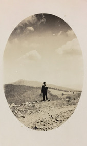
Photograph - Rural landscape, c.1926
Henry Beater Christian (1886-1962) , was a descendant of one of the earliest settler families in Kew. Employed at the Kew Asylum as a 'public servant', he was a skilled amateur photographer, photographing numerous scenes in Kew and on his travels around Victoria. The majority of his photographs date from 1916 to 1929. His finest photographs are housed in two photograph albums. Digital copy of a photograph from page 17 of the 47-page photograph album containing 261 gelatinous silver images, loaned by Diane Washfold with permission given to digitise and hold a copy in our collection. This photograph, dating from c.1926, forms part of a group of photos preceding images of [Black] Spur, so the photographs may have been taken as part of that bushwalking trip. John Chapman has written in 'Bushwalking Clubs - A Brief History', about the establishment in Victoria of the first bushwalking club in 1888, and the popularisation of bushwalking during the interwar period. Henry Christian's 'walks' appear to have been undertaken solely or with a companion/s. This camera shot invites the viewer to access the landscape through the point-of-view of the man standing with his back to the camera at the edge of the road. The man holds leaves in his left hand [to deter insects], and has a knapsack on his back. The landscape in the distance includes both cleared land for farming and remnant vegetation. The oval framing device was used when Henry Christian developed the photo.Illegible ink inscription on pagehenry beater christian (1886-1962), landscape photography, kew (vic.) — yarra river, christian-washfold collection, photograph albums, bushwalking -- victoria -
 Kew Historical Society Inc
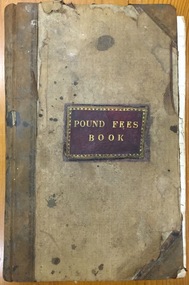
Administrative record (item), Borough of Kew, Pound Fees Book, 1874-1896
While the first successful land sales in Boroondara occurred in Hawthorn in 1843, and Kew in 1845, these areas were to be without local pounds until April 1858, when the Governor of Victoria, in accordance with Act 18 Victoria No 30, was pleased to direct the establishment of a Pound at Glass’s Creek on that part of land bounded by the Kilby Road, Burke Road and High Street. While the Governor was required to proclaim the establishment of a pound, the appointment of a poundkeeper was the responsibility of the Justices of the Peace in the local Court of Petty Sessions. The Pound took its name from the most distinctive natural feature of the area, Glass’s Creek, named after the early pastoralist Thomas Glass.The register is of historic significance as an indicator of suburban life in the second half of the 19th Century. It shows how farming and city life on the urban fringe were intimately connected. It is also significant to the early history of Hawthorn and Kew, who both claimed the Pound following their separation from the Boroondara Roads Board in 1861."Kew Pound Book"glass creek pound (kew), animal pound, dog pound, kew pound, j. smith, john oakes, samuel b. cash, edward s. delaney, emma oswin, samuel cash -
 Kew Historical Society Inc
Photograph, Wade's Farm, Kilby Road, Nineteenth Century
""The public trial of reaping machines, under the auspices of the Port Phillip Farmers' Society, advertised to take place on Friday, last, but postponed on account of the weather, came off December 27. The place selected (Mr. Wade's farm, Belford, near Kew) is undulating ground, with a remarkably heavy crop of wheat upon it. This, taken in connection with, the state of the ground, still soft from the recent rains, made the trial an uncommonly severe one. ..."(South Australian Advertiser, 15 January 1859) Some bricks used in Kew buildings came from the brickworks on Wade's Farm at the end of Belford Road near the Yarra River (now part of the Kew Golf Club). (History of RSL by John Torpey)Wade's Farm, Kilby Road, Kew.wade's farm, farming (kew), kilby road, north kew, belford road, kew, kew golf club -
 Sunbury Family History and Heritage Society Inc.
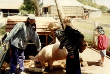
Photograph, School Excursion
The students from Bulla Primary School visited a farm in the local area to learn about farm life in the district, where there are many small hobby farms. In this photograph the girls came up close to a pig in its pen enjoying a meal.The farm excursion introduced to a variety of farming activities in their local area. a non-digital coloured photograph of four children standing in a pig pen while watching the animal eat its food.farms, pig farming, school excursions, bulla primary schooil -
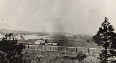
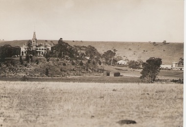 Sunbury Family History and Heritage Society Inc.
Photograph, 'Rupertswood', 17 March 1934
'Rupertswood' mansion, in Sunbury, was the former home of Sir Rupert Clarke. His original estate covered 137317 acres in various areas in the district of Bourke in the 1880s. The 'Rupertwood' property was eventually acquired by the Salesian Order and functioned as a boys' school where many were trained in farming skills. In the 1990s it became a coeducational secondary college. The Clarke family acquired and settled much land in the Sunbury area and today 'Rupertswood' Mansion is one of the surviving grand nineteenth century mansions in Victoria. The Catholic Church has also played a prominent role in educating many of the young people in the district. A sepia photograph of the 'Rupertswood' mansion set on a rise with surrounding farmland and some outbuildings.rupertswood mansion, salesian college, catholic church, catholic education, education, schools