Showing 1339 items
matching growth
-
 Hume City Civic Collection
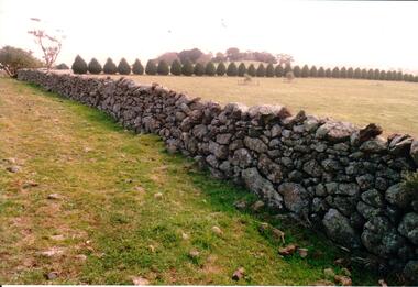
Photograph, Early 1990's
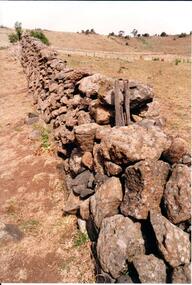
This is a photograph of one of the many stone ruins which can be seen in the Sunbury area and surrounding districts. These ruins are found in varying degrees of structural damage caused by erosion, vegetation growth and vandalism. The dry stone wall is at Crowes Hill at Yuroke.A coloured photograph of a dry stone wall with a row of shaped cypress trees running off at right angles to the fence. A small tree covered hill is in the distance.stone structures, dry stone walls, crowes hill, george evans collection -
 Phillip Island and District Historical Society Inc.
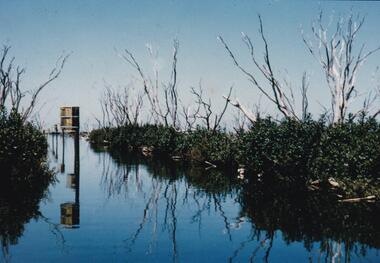
Photographs, Rhyll Swamp Bird Life
Selection from a collection of photographs given to John Jansson from the Estate of Bill Barrett - Fisheries & Wildlife on Phillip Island441-01: 2nd year growth of Fathom Hen Seeds underwater dormant for 12 years. 441-02: Photo of Bill checking nesting boxes in Rhyll Swamp 441-03: Black & White photo of Bill & helper 441-04: Bee Hive at Rhyll Swamp 441-05: Royal Spoon Bill with 12 eggs 441-06: Ibis Hatchlings 441-07:Chestnut Teal Duck eggs at Rhyll Swamp 441-08: Photo of a painting of a Mallard Duck with 6 ducklings. Descriptions written on back of photographsrhyll swamp phillip island, mallard duck, royal swamp hen, royal spoon bill, bill barrett, chestnut teal duck eggs, beehive at rhyll swamp, fathom hen plants at rhyll swamp, nesting boxes rhyll swamp, john jansson -
 Bendigo Historical Society Inc.
Book - AILEEN AND JOHN ELLISON COLLECTION: BOOKLET - CHILDREN NO LONGER
Small booklet (44 pages) "Children no longer" A guide for parents on understanding the adolescent. Published by The father and son welfare movement of Australia. Third edition September, 1958. Contents - Part 1: Physical development - The onset of puberty, the glands and how they function, general growth. Part 2: Psychological development - Mental capacity is reached, independence finding their own feet, vocation how and what shall they choose, sex development, some social and moral factors. Part 3: Spiritual development - the search for a purpose, the answer in God.books, school, sex education -
 Williamstown Botanic Gardens- Hobsons Bay City Council
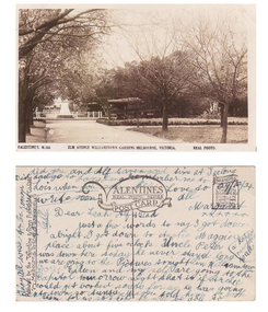
Postcard - Williamstown Botanic Gardens, circa 1900-1924
The original postcards in this series (2013.002 to 2013.018) were generously loaned to Williamstown Botanic Gardens by a private collector for copying. The postcards are evidence of the interest the gardens held as a subject for postcard publishers. The text and images provide a snapshot into fashions, social interests and concerns of the time. The professionally produced images provide a pictorial history of Gardens including changing planting styles, various structures and features of the Gardens eg the aviary, cannons, the fountain, the second Curator’s Lodge and gates. The images offer an opportunity to compare garden vistas with the present day. This postcard is evidence of the placement of two of the cannons relocated from Fort Gellibrand in 1906 and that they were in place in the Gardens in 1924. They were removed from the Gardens in the 1960s. These same cannons remain a feature on the Williamstown waterfront in 2013. The image also shows the original Elm Avenue plantings. A sepia scene looking west towards statue of Alfred Thomas Clark, with cannons on either side of statue pointing east down what is known as the Palm Avenue. The statue is surrounded by a white fence consisting of posts and a top rail. The top of the statue is hidden by the branches of the elm trees. It appears that the elms are in the process of either losing their leaves or new leaf growth. A cactus plant can be seen beneath the lower branches of the elm tree of the right closest to the camera. The cannons were moved from Fort Gellibrand to the Gardens in 1906.Front: VALENTINE’S, M.356 ELM AVENUE WILLIAMSTOWN GARDENS MELBOURNE, VICTORIA. REAL PHOTO. Reverse: vertical on left side of card and underlined: ‘Published by the Valentine & Sons Publishing Co. Ltd. / Melbourne, Sydney & Brisbane’. Top centre of card: Contains logo of ‘VALENTINES / REAL PHOTO SERIES / POSTCARD’. Top right hand corner is stamped ‘BRANCHES (enclosed in a scroll) / SYDNEY / LONDON / DUNDEE / DUBLIN / CAPETOWN / MONTREAL / TORONTO’ The card is dated ‘29/12/24’ and addressed to ‘Dear Leah Alf & Dad’ signed by ‘Margaret’. postcard, gardens, post-card, williamstown-botanic-gardens, hobsons-bay-city-council, statue, clarke, alfred-thomas-clarke, cannon, elm, cactus, 1924, fort-gellibrand, 1906, armstrong, clark -
 Flagstaff Hill Maritime Museum and Village
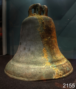
Ceremonial object - Church Bell, Before 1855
This artifact is a large brass bell. It was retrieved from the Schomberg wreck by local divers in the 1970s. Its location at the wreck site was described as "found on the west side towards the stern" the vessel remains lying on a north-south axis, with the bow pointing towards the shore as a result the bell was assessed from this position to have formed part of the cargo. The view that this was not a ship's bell belonging to the Schomberg is gained from two other 'Schomberg Bells' in the Flagstaff Hill collection, both of which have the vessel's name prominently etched into their outer surface. Additional indications indicate that this bell was not intended for maritime use due to the bell's rounded 'bell-curve' shape suggesting it was melodically tunable. Also the detailed basket-type fittings on the bell dome that would allow the bell to be suspended by ropes rather than just bolted to a yoke. The bell is currently on display at Flagstaff Hill, categorised as a church bell part of the Schomberg's cargo that was intended for use in a church within the Victorian colony. As the Colony of Victoria became more established, and its population expanded with the Gold Rush and other emigration from Britain, the demand for regular religious services and permanent church buildings also grew. We will never know if this bell was a specific order or part of an enterprising bell founder's consignment of general stock to a wholesale supplier in Melbourne. A cargo manifest for the Schomberg has unfortunately never been found. The shipwreck of the Schomberg is regarded as of significance to Victoria and is registered on the states Heritage list (S 612). The Schomberg wreck has great historical significance as a rare example of a mid 19th century large, fast clipper ship intended to transport cargo and passengers between England and Australia. The vessel that carried this bell represents the marine advances made in an attempt to break established sailing records between Europe and Australia. Flagstaff Hill holds a noteworthy collection of artefacts from the Schomberg shipwreck. The collection as a whole is primarily significant because of the relationship the objects have archaeologically, not only to highlight the story of the Schomberg ship and later it's wrecking but have an important potential to interpret the story and progression of maritime shipping in the 19th century. The church bell has a standard bell-curve shape and is dull bronze in colour. A large brass bell, plain and without visible maker marks, but with traditionally intricate basket-type cast fittings for suspension from a yoke by a number of ropes or chains. Approximately 3/8 of the bell’s outer surface bears a thin layer of marine growth and limestone accretion, and there is some minor pitting and spots of light verdigris over the remainder. The bell mouth, or lip, is slightly compressed-in in two places. It was retrieved from the wreck of the Schomberg. warrnambool, flagstaff-hill, flagstaff-hill-maritime-museum, maritime-museum, shipwreck-coast, flagstaff-hill-maritime-village, schomberg, shipwrecked-artefact, clipper ship, black ball line, 1855 shipwreck, aberdeen clipper ship, captain forbes, peterborough shipwreck, ss queen, brass bell, church bell -
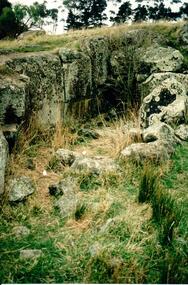 Hume City Civic Collection
Photograph, Early 1990's
This is a photograph of one of the many stone ruins which can be seen in the Sunbury area and surrounding districts. These ruins are found in varying degrees of structural damage caused by erosion, vegetation growth and vandalism. This is the remains of a bluestone quarry on the 'Oaklands' property at Oaklands Junction.A coloured photograph in portrait format of a basalt rock ruined structure which has been dug into a hillside with a line of trees in the background.stone structures, oaklands quarry, george evans collection -
 Kew Historical Society Inc
Plan - Subdivision Plan, Six Big Home Sites, Camberwell North, c.1936
Subdivision plans are historically important documents used as evidence of the growth of suburbs in Australia. They frequently provide information about when the land was sold on which a built structure was subsequently constructed as well as evidence relating to surveyors and real estate and financial agents. The numerous subdivision plans in the Kew Historical Society's collection represent working documents, ranging from the initial sketches made in planning a subdivision to printed plans on which auctioneers or agents listed the prices for which individual lots were sold. In a number of cases, the reverse of a subdivision plan in the collection includes a photograph of a house that was also for sale by the agent. These photographs provide significant heritage information relating house design and decoration, fencing and household gardens.A subdivision in what is currently Balwyn, but which was advertised as being in Camberwell North. The subdivision included six allotments facing Buchanan Avenue and Houghton Street. The subdivision was to the east of the Pointed Firs Estate (1936). In addition to the intrinsic value of this subdivision plan, it also reveals information about the development of transport infrastructure in this area. The subdivision plan notes that the Tramways Board has approved the extension of the tram route past the current terminus at Balwyn Road.subdivision plans - camberwell -
 Kew Historical Society Inc
Plan - Subdivision Plan, Windella-Darnley Subdivision, Studley Park, 1920s
Subdivision plans are historically important documents used as evidence of the growth of suburbs in Australia. They frequently provide information about when the land was sold on which a built structure was subsequently constructed as well as evidence relating to surveyors and real estate and financial agents. The numerous subdivision plans in the Kew Historical Society's collection represent working documents, ranging from the initial sketches made in planning a subdivision to printed plans on which auctioneers or agents listed the prices for which individual lots were sold. In a number of cases, the reverse of a subdivision plan in the collection includes a photograph of a house that was also for sale by the agent. These photographs provide significant heritage information relating house design and decoration, fencing and household gardens.Version 1 of two subdivision plans (the later one is MAP.0027) for the section of Studley Park Road near the Junction on the south side. Named in the subdivision are the mansions of Darley and Windella (now demolished). Before the subdivision of Darley and Windella, both houses fronted Studley Park Road. Both houses appear to be advertised as lots in the subdivision. Bisecting the subdivision is a street, Antrim Avenue that was never constructed. A street, which was subsequently constructed in this vicinity, was Merrion Place, which now runs between Studley Park Road and Highfield Grove. There are 14 proposed lots in this subdivision."Antrim Avenue. See over for new plan"subdivision plans - kew, studley park, windella, darnley, studley park road -- kew (vic.), merrion place -- kew (vic.), merrion grove -- kew (vic.), highbury grove -- kew (vic.) -
 Kew Historical Society Inc
Plan - Subdivision Plan, Shop Sites, East Kew, c.1927
Subdivision plans are historically important documents used as evidence of the growth of suburbs in Australia. They frequently provide information about when the land was sold on which a built structure was subsequently constructed as well as evidence relating to surveyors and real estate and financial agents. The numerous subdivision plans in the Kew Historical Society's collection represent working documents, ranging from the initial sketches made in planning a subdivision to printed plans on which auctioneers or agents listed the prices for which individual lots were sold. In a number of cases, the reverse of a subdivision plan in the collection includes a photograph of a house that was also for sale by the agent. These photographs provide significant heritage information relating house design and decoration, fencing and household gardens.This is one of a small number of subdivision plans for commercial property in the collection. The subdivision proposed to create six shop sites in High Street between the Harp of Erin and Station Street. The plan shows this stretch of High Street, East Kew already lined with shops that include the hotel on the corner, the new State Savings Bank, a dentist’s surgery and Lambert’s Store. The High Street Tram was to reach Burke Road in 1925, so the proposed subdivision must postdate that event, and the opening of the Bank in 1926.subdivision plans - east kew, high street - east kew -
 Kew Historical Society Inc
Plan - Subdivision Plan, Eastlawn Estate, 1914
Subdivision plans are historically important documents used as evidence of the growth of suburbs in Australia. They frequently provide information about when the land was sold on which a built structure was subsequently constructed as well as evidence relating to surveyors and real estate and financial agents. The numerous subdivision plans in the Kew Historical Society's collection represent working documents, ranging from the initial sketches made in planning a subdivision to printed plans on which auctioneers or agents listed the prices for which individual lots were sold. In a number of cases, the reverse of a subdivision plan in the collection includes a photograph of a house that was also for sale by the agent. These photographs provide significant heritage information relating house design and decoration, fencing and household gardens.The ‘Eastlawn Estate’ was surveyed and ready for auction in March 1914, three months before the outbreak of World War I. Sixty-six allotments, created on the ‘order of Mr & Miss Preston’ surrounded the mansion of Woodlands in Harp Road. Woodlands formed part of the Estate, being advertised as lot 1. The allotments faced High, Station and Wright Streets, Harp and Normanby Roads, and Woodlands Avenue. Pru Sanderson in the Kew Conservation Study (Vol.2, 1988) wrote that the Eastlawn Estate ‘covered the western half of the failed Harp of Erin Estate’. Contemporary advertisements promoted the Eastlawn Estate as: ‘There will be no more convenient district nor pleasant Suburb than East Kew for the busy business man. When the Electric Tram is laid, he will be able to journey quickly and pleasantly direct from Collins Street to his home in the Eastlawn Estate in about 20 minutes’. The actual plans of subdivision were included in advertisements in The Argus and in the local newspapers.subdivision plans - east kew, eastlawn estate -
 Kew Historical Society Inc
Plan - Subdivision Plan, Raheen Estate Subdivision, 1960
Subdivision plans are historically important documents used as evidence of the growth of suburbs in Australia. They frequently provide information about when the land was sold on which a built structure was subsequently constructed as well as evidence relating to surveyors and real estate and financial agents. The numerous subdivision plans in the Kew Historical Society's collection represent working documents, ranging from the initial sketches made in planning a subdivision to printed plans on which auctioneers or agents listed the prices for which individual lots were sold. In a number of cases, the reverse of a subdivision plan in the collection includes a photograph of a house that was also for sale by the agent. These photographs provide significant heritage information relating house design and decoration, fencing and household gardens.The Raheen Estate Subdivision of 1960 involved the creation of 36 residential allotments and the sale of 34 of these. The land on which the subdivision was created had until 1960 formed part of the grounds of the mansion Raheen in Studley Park Road. In 1917, the Catholic Church had purchased Raheen and its lands. It was to become the home of Archbishop of Melbourne, Daniel Mannix, for 46 years. The sale of the subdivision took place three years before the Archbishop’s death. Subsequent archbishops were to reside at Raheen until its sale to the Pratt family in 1981. When the sale of the Estate was reported in the newspapers in 1960, it was described as the last big subdivision near Melbourne. At the auction, 33 of the 36 allotments were sold. The auction realised £315,750. Purchasers were advised that the vendor intended to keep lots 22 and 23. The alllotments in the subdivision required the construction of new roads. These included Eamon Court and Raheen Drive. The justification provided by the Church for the sale was that the estate was being sold to finance school building projects.subdivision plans - kew, studley park, raheen estate, eamon court, studley park road, coombes avenue, raheen drive -
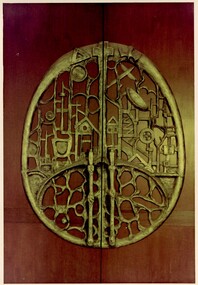 Damascus College
Sculpture - Door panel sculpted by Hans Knorr (1915-1988) in 1968, 'Education and Achievement'
“The theme of the panel is education. From man’s primeval roots, and from beginnings symbolised by the two ovoid shapes, which are both basic and universal, man is raised by his natural yearning and by education towards things of the spirit; so that in the second level of the panel we see a church building and a book, a dam and the ploughed field, such diverse inventions as the crucible and the wheel, the aeroplane and the radar screen, and symbols of commerce and culture. The continuing central pillar, or tree, symbolises the life of Christ which binds together and culminates, not only in the Cross but in the full Unity of Father, Son and Holy Spirit.” Large sculpture by artist Hans Knorr (1915-1988) symbolising humanity's growth and progress through effort, experience and education. The door panel was commissioned by the Sisters of Mercy in 1967 on the opening St Martin's in the Pines (Sacred Heart College, Senior School).Door panel sculpted in aluminium hans knorr, sculpture, catholic education, education -
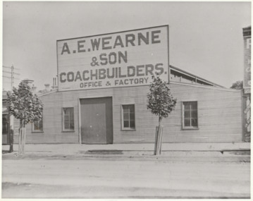 Port Melbourne Historical & Preservation Society
Photograph - A E Wearne & Son Coachbuilders, Port Melbourne, Jack GOULD, C. 1950s
From a box of photographs in Nancy U'REN's papers used during research for her thesis, The Early Growth and Development of Sandridge (1976) and/or her book with Noel TURNBULL, A History of Port Melbourne (1983). Jack GOULD probably created this from an earlier photograph.Black and white photograph of the premises of A E Wearne & Son, Coachbuilders.a e wearne & son, nancy u'ren nee morris -
 Port Melbourne Historical & Preservation Society
Photograph - Aerial view of Port Melbourne piers and foreshore, Jack GOULD
From a box of photographs in Nancy U'REN's papers used during research for her thesis, The Early Growth and Development of Sandridge (1976) and/or her book with Noel TURNBULL, A History of Port Melbourne (1983). Jack GOULD probably created this from an earlier photograph.Black and white aerial photograph showing the Port Melbourne foreshore and the piers from Princes Pier to Lagoon Pier and beyond. C. 1922-23.piers and wharves - princes pier, piers and wharves - town pier, piers and wharves - lagoon pier, foreshore, piers and wharves - railway pier, nancy u'ren nee morris -
Port Melbourne Historical & Preservation Society
Photograph - Railway Pier, Port Melbourne, Jack GOULD
From a box of photographs in Nancy U'REN's papers used during research for her thesis, The Early Growth and Development of Sandridge (1976) and/or her book with Noel TURNBULL, A History of Port Melbourne (1983). Jack GOULD probably created this from an earlier photograph.Black and white photograph looking along Railway Pier with many sailing ships berthed on either side. C. 1880s.piers and wharves - railway pier, transport - shipping, nancy u'ren nee morris -
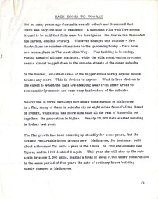 Robin Boyd Foundation
Document - Manuscript, Robin Boyd, Back Doors to Toorak, 1964
Boyd reflects on the increasing growth of apartments built in the urban fabric. The growing demand for flats also contributes to the increasing number of developers who, to Boyd's dismay follow the bare minimum in the Code of Buildings that ultimately contributes and affects the romantic visions of the Australian landscape.Original manuscript of an article titled 'The Flat Revolution' published in The Australian, 13.11.1964.Typewritten (c copy), quarto, 5 pagesflat building, developer, building code, urban living, robin boyd, manuscript -
 Kew Historical Society Inc
Plan - Subdivision Plan, Windella-Darnley Subdivision, Studley Park, 1920s
Subdivision plans are historically important documents used as evidence of the growth of suburbs in Australia. They frequently provide information about when the land was sold on which a built structure was subsequently constructed as well as evidence relating to surveyors and real estate and financial agents. The numerous subdivision plans in the Kew Historical Society's collection represent working documents, ranging from the initial sketches made in planning a subdivision to printed plans on which auctioneers or agents listed the prices for which individual lots were sold. In a number of cases, the reverse of a subdivision plan in the collection includes a photograph of a house that was also for sale by the agent. These photographs provide significant heritage information relating house design and decoration, fencing and household gardens.Version 2 of two subdivision plans (the earlier is 2016.0305.1) for the section of Studley Park Road near the Junction on the south side. Named in the subdivision are the mansions of Darley and Windella (now demolished). Before the subdivision of Darley and Windella, both houses fronted Studley Park Road. Both houses appear to be advertised as lots in the subdivision. Bisecting the subdivision is a street, Antrim Avenue that was never constructed. A street, which was subsequently constructed in this vicinity, was Merrion Place, which now runs between Studley Park Road and Highfield Grove. There are 13 proposed lots in this subdivision in contrast to the earlier plan. This resulted from larger lots being proposed for Studley Park Road.subdivision plans - kew, studley park, windella, darnley, antrim avenue -- kew (vic.), studley park road -- kew (vic.), merrion place -- kew (vic.), merrion grove -- kew (vic.), highbury grove -- kew (vic.) -
 Robin Boyd Foundation
Document - Manuscript, Robin Boyd, Australian Architecture, 1971
Discussion of Architectural professional techniques (organisation of the profession, from the societies, registration etc and the growth in the profession, office practices) public and private practices (eg Commonwealth Department of Works,), research and regulations (eg building research, CSIRO), and theory and practice (the vernacular, the professional and the creative).Original manuscript of an article published as 'Architecture in Australia’ in RIBA Journal, Vol.78, No.1, January 1971, pp.11-20.Typewritten (p/copy), quarto, 22 pagesaustralian architecture, royal australian institute of architects, the architecture profession, package dealing, australian architecture students association, public and private practice, commonwealth department of works, building research, csiro, building regulations, john andrews, robin boyd, manuscript -
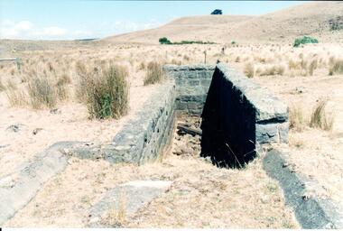
 Hume City Civic Collection
Photograph, Early 1990's
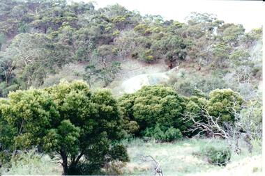
This is a photograph of one of the many stone ruins which can be seen in the Sunbury area and surrounding districts. These ruins are found in varying degrees of structural damage caused by erosion, vegetation growth and vandalism. The post and stone fence at Emu Creek at Bulla is more intact in this photograph.A coloured photograph of a post and stone fence surrounded by sun drenched paddocks.stone structures, post and stone fences, emu creek, george evans collection -
 Melbourne Legacy
Administrative record - Minutes, State Conference - Legacy in Victoria - From 1946 to 1960, 1946-1965
Records the conferences held to co-ordinate and inform the activities of all the Victorian Legacy Cubs. Almost complete run of records from 1946 to 1965 telling the story of the growth and work of Legacy Clubs throughout Victoria. Items to be added individually post COVID. TBC.A record of conferences held from the 1940s to 1960s. White foolscap paper with black type; 00211.1 31 August 1946 00211.2 11 December 1948 00211.3 10 December 1949 00211.4 9 December 1950 00211.5 23 June 1951 00211.6 6 December 1952 00211.7 5 December 1953 00211.8 4 December 1954 00211.9 10 December 1955 00211.10 28 July 1956 00211.11 3 August 1957 00211.12 13 September 1958 00211.13 8 November 1958 00211.14 21 March 1959 00211.15 12 September 1959 00211.16 20 August 1960 00211.17 19 August 1961 00211.18 16 June 1962 00211.19 15 June 1963 00211.20 19 June 1965 00211.21 Index 1946 - 1960conference, minutes, legacy clubs, conference minutes -
 Wodonga & District Historical Society Inc
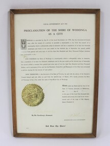
Certificate - Proclamation of the Shire of Wodonga as a City, 1973
The framed certificate proclaiming the Shire of Wodonga as a City in 1973 documents the development of Wodonga as an important rural city in the north east of Victoria. The decentralisation of industry and the establishment of international companies in Wodonga in the second half of the 20th century contributed to the growth of Wodonga as a major regional centre.The certificate proclaiming the Shire of Wodonga as a City in 1973 has local significance as it documents the history and development of Wodonga. It also has state significance as part of the history of the regional development of Victoria from the mid-20th century onwards.Thin wooden frame with gold trim around a certificate with the text in black proclaiming the Shire of Wodonga as a City dated to 1973. Embossed gold seal of the State of Victoria on the left side of the text in the lower part of the certificate. Signed by the Governor of Victoria, Sir Rohan Delacombe and the Victorian Minister for Local Government.wodonga shire, wodonga, rural cities in victoria, victorian state government certificates -
![Scene near Dandenong, Moon’s Range / [by] Nicholas Caire, circa 1876](/media/collectors/550653872162f11fb04854aa/items/577b555cd0cdd10948ce10bf/item-media/577b55cfd0cdd10948ce3edc/item-fit-380x285.jpg) Kew Historical Society Inc
Kew Historical Society IncPhotograph, Anglo-Australasian Photographic Company, Scene near Dandenong, Moon’s Range, c. 1876
Nicholas Caire was born on Guernsey in the Channel Islands in 1837. He arrived in Adelaide with his parents in about 1860. In 1867, following photographic journeys in Gippsland, he opened a studio in Adelaide. From 1870 to 1876 he lived and worked in Talbot in Central Victoria. In 1876 he purchased T. F. Chuck's studios in the Royal Arcade Melbourne. In 1885, following the introduction of dry plate photography, he began a series of landscape series, which were commercially successful. As a photographer, he travelled extensively through Victoria, photographing places few of his contemporaries had previously seen. He died in 1918. Reference: Jack Cato, 'Caire, Nicholas John (1837–1918)', Australian Dictionary of Biography.An original, rare photograph from the series 'Views of Victoria: General Series' by the photographer, Nicholas Caire (1837-1918). The series of 60 photographs that comprise the series was issued c. 1876 and reinforced a neo-Romantic view of the Australian landscape to which a growing nationalist movement would respond. Nicholas Caire was active as a photographer in Australia from 1858 until his death in 1918. His vision of the Australian bush and pioneer life had a counterpart in the works of Henry Lawson and other nationalist poets, authors and painters.Views of Victoria (General Series) No.28 / ‘Scene near Dandenong, Moon’s Range’ / Albumen silver photograph mounted on boardOn Reverse: 'Moon’s Range is situated to the right of the portion of the Dandenong Range of Mountains called “Fern Tree Gully.” This Range is notable for its almost impenetrable forest of trees, the majority of them being of gigantic growth. Numerous splitters and wood-cutters obtain lucrative employment in the production of laths and firewood. Near the summit of the range are several summer residences belonging to Melbourne merchants.’nicholas caire (1837-1918), australia - landscape photography -
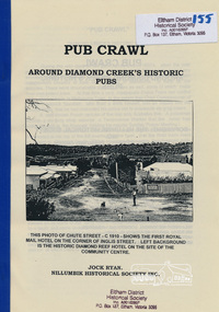 Eltham District Historical Society Inc
Book, Nillumbik Historical Society, Pub Crawl: around Diamond Creek's historic pubs by Jock Ryan, 2001
Hotels described include: Evelyn Arms Hotel or Tunnel Camp Hotel or Half-Way House, the Diamond Reef Hotel, the Loyal Diamond Lodge Hotel and the Royal Mail Hotel all located in Diamond Creek during a rapid population growth in Diamond Creek in the 1860s.This small publication discusses the history of local hotels in the Diamond Creek area during a significant period of development in the 1860s when mining took place in the local area. The history of hotels connects to the wider history and important social and civic link to the community at that time. [10] p. includes text and very poor photocopy reproductions of historical photographs. Perfect bound with plastic front cover only.EDHS Property stamp on front coverdiamond creek, hotels, pubs, bars, 1860s -
 Hume City Civic Collection
Photograph, Early 1990's
This is a photograph of one of the many stone ruins which can be seen in the Sunbury area and surrounding districts. These ruins are found in varying degrees of structural damage caused by erosion, vegetation growth and vandalism. The bluestone structure was a sheep dip on the 'Karoora Park' property near Jacksons Creek.A coloured photograph of the stone remains of a sheep dip constructed from basalt rock. The ground at the entrance slopes down into a narrow walled channel. The surrounding paddocks are covered with tussocks of grass and there are bare hills in the background. The grass is brown.stone structures, sheep dips, basalt rock, 'karoora park', george evans collection -
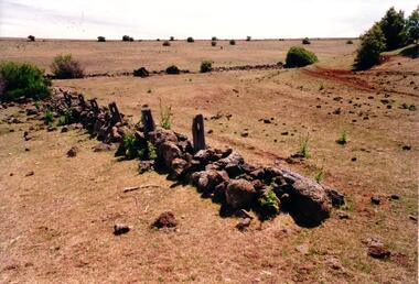 Hume City Civic Collection
Photograph, Early 1990's
This is a photograph of one of the many stone ruins which can be seen in the Sunbury area and surrounding districts. These ruins are found in varying degrees of structural damage caused by erosion, vegetation growth and vandalism. The remains of the post and stone fence can be seen near Emu Creek at Bulla.A coloured photograph of the remains of a low post and stone fence in a sunburnt paddock. There are a few low growing bushes dotted across the paddocks.stone structures, dry stone walls, post and stone fences, george evans collection -
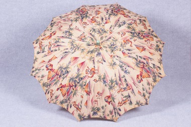 Brighton Historical Society
Accessory - Parasol, 1920s
Printed with colourful pyramids, palm trees and camels, this parasol tells a story of the changing society of the 1920s, the growth of the Art Deco movement and a wave of Egyptomania sparked by the discovery of Tutankhamun’s tomb. Parasols such as this one were used by holidaymakers on Brighton Beach, by this time a popular seaside destination.Parasol with a cotton canopy printed with an Egyptian-inspired design of the Sphinx, camels, palm trees and water carriers. Painted handle with plaited cotton tassel with pink wooden bead.parasol, 1920s, egyptomania -
 Federation University Historical Collection
Magazine, Popular Radio and Aviation, 1929, 01/03/1929
Vol. 1., No 10, 67 page magazine including articles - Aviation Developes New Guinea Gold Fields, Radio on the High Seas, Radio and the Weather, Aircraft Building in Australia, Along the Short Waves, Secrets of the Talkies, The Growth of Radio in Aviation, Progress in Aviatin, Some New Radio Patents, Complete List of Australian Call Signs. Includes images and advertisements, Rod McGregor, Richard Berry, Wireless operator, Zepplins, De Havilland Tiger Moth, Avro aeroplane, Spartan Light Plane, Mrs S.C. Elliott-Lynn.radio, aeroplane, avro, tiger moth -
 Hume City Civic Collection
Photograph, Early 1990's
This is a photograph of one of the many stone ruins which can be seen in the Sunbury area and surrounding districts. These ruins are found in varying degrees of structural damage caused by erosion, vegetation growth and vandalism. The adit and mullock heap is from one of the mines on Redstone Hill. It was known as Batey's Mine.A coloured photograph of the remains of a mullock heap and adit from a mine. The entrance is surrounded by low growing trees and grass.stone structures, batey's mine, gold mining, redstone hill, george evans collection -
 Melton City Libraries
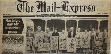
Newspaper, Nostalgic day for historical group, 1984
"Edna Barrie was a founding member of the Melton & District Historical Society in 1968, and was passionate about preserving and sharing local history. The formation of the society at that time, during a period of increasingly rapid growth for the municipality, was crucial, ensuring that many photos, documents and stories of early Melton were not lost".The Mail Express article featuring the Melton and District Historical Grouplocal identities, local significant groups -
 Port Fairy Historical Society Museum and Archives
Photograph
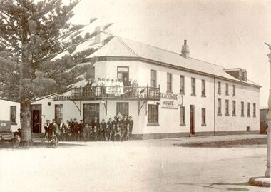
Seacombe House also known as The Stag was built 1848-1854 , in its early days it contained a billiard room, a 20 stall livery stable and coach house, and 44 apartments as well as the cottage, it failed to sell in 1869 due to 12 other licensed premises and lack of growth prospects.Black and white Photograph of 2 story rendered building with small corner balcony large group of males and females posed in front, pine tree to the left with rear of carhotel, stag, seacombe, workers, stag inn, seacombe house, sackville street, cox street, stag hotel