Showing 2958 items
matching highway
-
 City of Kingston
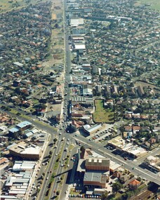
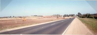
Photograph - Colour, c. 1982
This aerial photograph of South Road and Nepean Highway, Moorabbin shows the area where houses and shops on the south side of the Nepean Highway have demolished for the widening of the highway. The pressures of rapid urban development in Moorabbin and beyond, especially to the south of Moorabbin caused bottlenecks and delays, especially at the South Road and Nepean Highway intersection, hence the scheme to widen Nepean Highway.The pressures of rapid urban development in terms of people, housing construction, industrial development and commercial activity, in Moorabbin and beyond, especially to the south would put pressure on road infrastructure in the region. In the early 1980s, a major road expansion of the Nepean Highway was implemented to increase capacity on this major thoroughfare for vehicle commuters. Car use had also increased with commuters from the increasingly populous southern suburbs travelling to their place of work in the Melbourne CBD.Colour photograph of an aerial view of South Road and Nepean Highway, Moorabbin. The image shows houses on the south side of the Nepean Highway that have demolished for widening of road. It features housing and commercial buildings looking north towards Cummins Road.Handwritten blue ink: 82 - 5452 - 11 Handwritten red ink: 112% Handwritten black ink: Ch. 7nepean highway, south road, moorabbin, roads, transport, infrastructure -
 Ringwood and District Historical Society
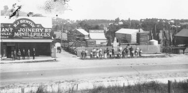
Photograph, Maroondah Highway East, Ringwood- 1920. H.J. Bently, Timber Merchant and Joinery
Black and white photograph (2 copies) Typed below one photograph: "Maroondah Highway 1920. Coffeys now on right and building on left still there (1979)" Written on rear of backing sheet: "Whitehorse Road 1920- Coffeys site- looking north. Shop now rebuilt and occupied by Lawford. Building behind 'H. J. Bentley' sign still there 1976 as part of Lawfords. Matlocks Livery Stables in background to left of 'Lime and Cement' sign. -
 Ringwood and District Historical Society
Photograph, Maroondah Highway West, Ringwood- 1925. Outside the Ringwood Market
Black and white photograph (2 images MHW0025a and MHW0025b)Image MHW0025a: (2 copies) Typed under one photograph: "Outside the Ringwood Market in Maroondah Hwy, 1925. Shop in centre now SEC site at cnr Ringwood St. S.S.B. building still on site shown to left." Image MHW0025b: (2 copies) Typed under one photograph: "Maroondah Highway looking East towards cnr Ringwood Street and Wantirna Rd. Ringwood market in centre. -
 Lakes Entrance Historical Society
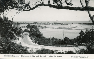
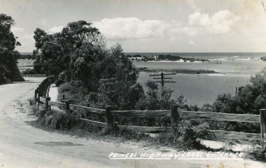
Postcard - Bullock Island, Bulmer H D, 1930C
2x black and white small format postcards both 6x9|1x tinted small format postcard 6x9|All above show inscription 'Road and Entrance'Black and white postcard of Princes Highway, entrance and Bullock Island taken from Kalimna Hill Lakes Entrance, VictoriaPrinces Highway, Entrance and Bullock Island, Lakes Entrancecoast, fences, roads and streets -
 Lakes Entrance Historical Society
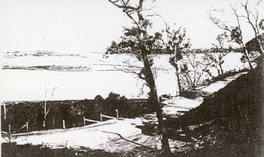
Postcard, Bulmer H D, 1920c
Black and white copy same sizeTinted postcard of a bend in the Princes Highway, Jemmys Point. It shows the road between the steep cutting and post and rail fence. Glimpse of footbridge to Bullock Island, entrance and hummocks. Lakes Entrance VictoriaPrinces Highway, Lakes Entrance topography, waterways, roads and streets -
 Lakes Entrance Historical Society
Photograph - The Entrance, 1910c
Black and white photograph of the Princes Highway at Kalimna. It shows the road around Jemmys Point. Bullock Island and a distant view of the man made entrance. Gumtrees along roadside. Lakes Entrance VictoriaThe Entrance from Princes Highwayroads and streets, vegetation, fences, waterways -
 Rutherglen Historical Society
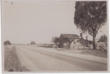
Photograph - Image, 1949
Black and white photograph of a weatherboard building set close to the edge of a highwayOn back of photo: "Old miners Post Office on Murray Valley Highway near Rutherglen 1949"miners post office, murray valley highway, post offices, gold mining -
 Ringwood and District Historical Society
Photograph, Maroondah Highway East, Ringwood- 1973. Westward view from Braeside Avenue along Maroondah Highway
Black and white photographWritten on rear of backing sheet: "Ringwood from Braeside Av. 9/73". -
 Ringwood and District Historical Society
Photograph, Maroondah Highway Central, Ringwood. Railway Station entrance facing Maroondah Highway, Ringwood - 1939
Black and white photograph (2 copiesTyped below photograph: "Marking out foundations of shops. Left hand corner of Station entrance - 1939". -
 Ringwood and District Historical Society
Photograph, Trees lining north side of Maroondah Highway between New Street and Ringwood Street, Ringwood - 1926. Auction Sale sign is shown on the eventual Holeproof factory site, later street numbered around 103 Maroondah Highway, Ringwood
Catalogue card reads, "Public Auction 1926. Saturday 29th May 1926. Holeproof factory once stood on this site. Billy Guyatt's discount store now occupies the site. (3 copies)". -
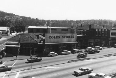
 Ringwood and District Historical Society
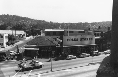
Photograph, Maroondah Highway Central, Ringwood. Clocktower view of Ringwood Street and Maroondah Highway corner, 1969
Black and white photographImage shows view down Ringwood Street with Loughnans Hill in background, and overlooking telephone exchange. Also shows Post Office, Coles Stores, and State Savings Bank. -
 Ringwood and District Historical Society
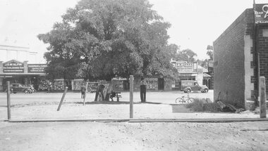
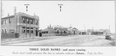
Photograph, Maroondah Highway Central, Ringwood. 1924 Land Sale brochure image of Maroondah Highway, Ringwood
Black and white photograph (2 copies)Typed below one copy: "Three solid banks - and more coming. Banks don't build premises like this in suburbs without a future. Take the Hint". Written on back of this photograph: "State Savings Bank, Bank of Victoria, Mechanics Institute, E.S. & A. in 2 storey Bld. 1924." Written on rear of backing sheet of other photograph, "1924, SSB Bank, Bank of Victoria, Ringwood Hall, shops then Coffee Palace and E.S. & A. Bank". -
 Ringwood and District Historical Society
Photograph, Maroondah Highway Central, Ringwood. Clocktower view of Ringwood Street and Maroondah Highway corner, 1969
Black and white photographImage shows Post Office on corner of Ringwood Street, Coles Stores, and State Savings Bank. -
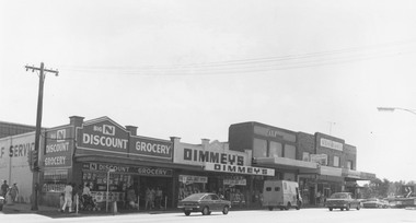 Ringwood and District Historical Society
Photograph, Maroondah Highway Central, Ringwood. Shops on the north-east corner of Melbourne Street and Maroondah Highway, c.1970
Black and white photographShops in photograph are 'Big N Discount Grocery, Dimmey's, ANZ Bank, Sound and Camera'. Safeway roof can be seen in the distance. -
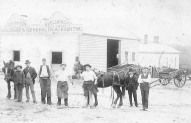 Ringwood and District Historical Society
Photograph, Maroondah Highway Central, Ringwood. Workers outside D.R. Kennedy's blacksmith shop, corner of Adelaide Street and Maroondah Highway
2 photographs (1 large black and white, 1 small sepia)Typed under large photograph: "Originally Mr Tommy Grants smithy in Maroondah Hwy. Built 1880." David Robert Kennedy took over the business from Ringwood's original blacksmith mr Tommy Grant in 1894. -
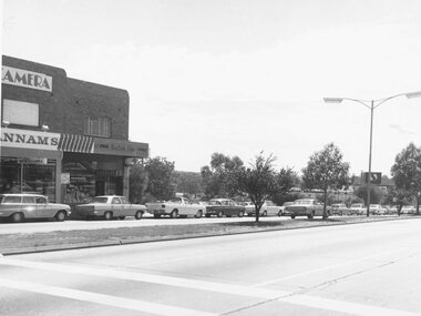 Ringwood and District Historical Society
Photograph, Maroondah Highway Central, Ringwood. Eastland frontage to Maroondah Highway, 1973
Black and white photographWritten on rear of backing sheet: "Eastland frontage to Maroondah Hwy. 1973". -
 Ringwood and District Historical Society
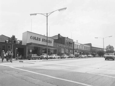
Photograph, Maroondah Highway Central, Ringwood. Shops in Maroondah Highway looking east from Ringwood Street. c1974
Black and white photographImage shows shops on north side of the road including Coles Stores, State Savings Bank, and Midway Arcade. -
 Ringwood and District Historical Society
Photograph, Maroondah Highway Central, Ringwood. Roadworks in Maroondah Highway, c1926
2 photographs (1 large, 1 small sepia) -
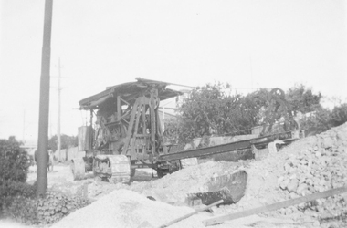
 Ringwood and District Historical Society
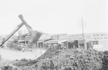
Photograph, Maroondah Highway Central, Ringwood. Roadworks in Maroondah Highway, c1926
Black and white photograph (2 copies- 1 large, 1 small) -
 Ringwood and District Historical Society
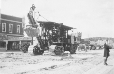
Photograph, Maroondah Highway Central, Ringwood. Roadworks on Maroondah Highway, c1930
2 copies of photograph (1 large black and white, 1 small sepia) -
 Ringwood and District Historical Society
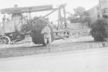
Photograph, Maroondah Highway Central, Ringwood. Roadworks on Maroondah Highway, 1935
2 photographs (1 large black and white, 1 small sepia) -
 Lakes Entrance Historical Society
Photograph - Tambo River
Also a black and white postcard Omeo Highway 05192.1 and .2Black and white photograph of Tambo River along the Omeo Highway Victoriawaterways, roads and streets -
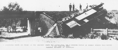 Ringwood and District Historical Society
Photograph, Ringwood derailment on 11 Feb 1908 at Wantirna Rd. underpass looking north. Maroondah Highway near trees beyond underpass
Black and white photographs - 2 copiesPrinted directly below photographs, "1. overturned engine and tender at the 'dead end' which was carried away. The X indicates position of fireman McKeone when rescued. 2. View from the road. Railway accident at Ringwood". Typed below photograph, "Ringwood derailment 1902 at Wantirna Rd. underpass looking north. Maroondah Highway near trees beyond underpass". Date incorrect, should be 11 Feb 1908 (as per item 2019) - refer to The Argus article published on Wednesday 12 February 1908, page 7. Thanks to railway enthusiast Neal Glover for pointing out the error. -
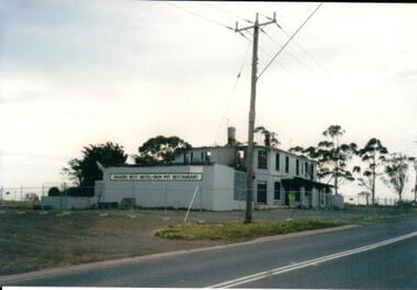 Hume City Civic Collection
Photograph, 1990s
The fire damaged building is the former Diggers Rest Hotel which was ruined by fire in the 1990s. It was the last standing and operating hotel along the Calder Highway between the towns of Keilor and Gisborne. A coloured photograph of a fire gutted building along a roadside with gum trees in the background. -
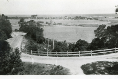
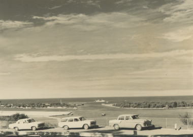 Lakes Entrance Historical Society
Photograph - Jemmys Point, Lakes Entrance c1960, Jemmys Point, Lakes Entrance c1960, 1960 c
View of the entrance taken from a bend in the Princes Highway showing three cars parked at the viewing area beside the highway. Boat and dredge in waterway below highway dredged sand in Bullock Island extension, dredge Mathew Flinders working outside the entrance Lakes Entrance Victoria. Also two black and white photographs taken of Entrance from Jemmys Point taken 1960 c Black and white photograph of the entrance taken from a bend in the Princes Highway showing three cars parked at the viewing area beside the highway. Boat and dredge in waterway below highway dredged sand in Bullock Island extension, dredge Mathew Flinders working outside the entrance Lakes Entrance Victoria. Also two black and white photographs taken of Entrance from Jemmys Point taken 1960 c waterways, vehicles, jemmys point lakes entrance -
 Hume City Civic Collection
Photograph, 1990s
The building which has been damaged by fire is the former Diggers Rest Hotel which was the only surviving hotel along the Calder Highway between the towns of Keilor and Gisborne a distance of approx. 32kms A coloured photograph of a grey rendered building, along a roadside, which has been damaged by fire with a temporary fence surrounding the building. diggers rest, hotels -
 Hume City Civic Collection
Photograph
This photograph is of the duplication of the Calder Highway at Diggers Rest in the vicinity of Plumpton Road.A coloured panoramic view of the construction of the duplication of the Calder Highway in the vicinity of Plumpton Road. It is unmounted.calder highway, diggers rest, highway duplication, road construction and maintenance, plumpton road, george evans collection -
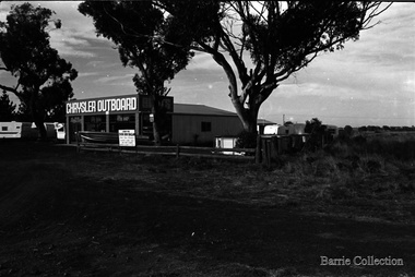 Melton City Libraries
Photograph, Chrysler Outboard, 1975
Photos taken by Bon Barrie. Western Highway was changed to High Street.Chrysler Outboard, located on Western Highway, Melton. Skin Inn Ballan advertisement on fencelandscapes of significance -
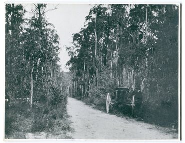 Orbost & District Historical Society
black and white photograph, 1913
This photograph shows the regrowth of vegetation on the road between Genoa and the border - now the Princes Highway.This is a pictorial record of the main road from Orbost to the New South border, The Princes Highway, in the early 20th century.A large black / white photograph of a bush road wwith a vehicle and a man on the side of it.on back - " Princes Highway showing the regrowth.....1913"princes-highway-genoa transport -
 Lakes Entrance Historical Society
Postcard, Bulmer H D, 1950c
Also one other postcard same donated by M & V Carpenter in spares box.Black and white postcard of the Princes Highway Jemmys Point, showing Bullock Island between North Arm and Cunninghame Arm, distant view of the entrance from Bass Strait to the Gippsland Lakes. Post and rail fence along roadside. Lakes Entrance VictoriaPrinces Highway and a view of the Entrance vegetation, roads and streets