Historical information
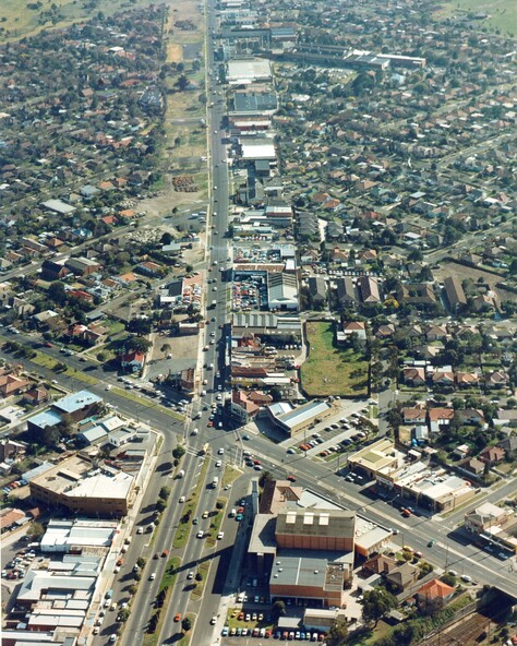
This aerial photograph of South Road and Nepean Highway, Moorabbin shows the area where houses and shops on the south side of the Nepean Highway have demolished for the widening of the highway. The pressures of rapid urban development in Moorabbin and beyond, especially to the south of Moorabbin caused bottlenecks and delays, especially at the South Road and Nepean Highway intersection, hence the scheme to widen Nepean Highway.
Significance
The pressures of rapid urban development in terms of people, housing construction, industrial development and commercial activity, in Moorabbin and beyond, especially to the south would put pressure on road infrastructure in the region. In the early 1980s, a major road expansion of the Nepean Highway was implemented to increase capacity on this major thoroughfare for vehicle commuters. Car use had also increased with commuters from the increasingly populous southern suburbs travelling to their place of work in the Melbourne CBD.
Physical description
Colour photograph of an aerial view of South Road and Nepean Highway, Moorabbin. The image shows houses on the south side of the Nepean Highway that have demolished for widening of road. It features housing and commercial buildings looking north towards Cummins Road.
Inscriptions & markings
Handwritten blue ink: 82 - 5452 - 11
Handwritten red ink: 112%
Handwritten black ink: Ch. 7
Subjects
References
- Cribbin, J., 1995, 'A City of Size and Substance 1960s to 1990s', Moorabbin: A Pictorial History 1862-1994, pp172-189, pg172