Showing 223 items matching "indigenous people"
-
 Eltham District Historical Society Inc
Photograph - Digital Photograph, Marguerite Marshall, Jesse Tree playing the Didgeridoo and Swiss Hang Drum at St Andrews Market, 29 March 2008
Published: Nillumbik Now and Then / Marguerite Marshall 2008; photographs Alan King with Marguerite Marshall.; p175 It’s Saturday morning and thousands of people are visiting St Andrews Market at the corner of Heidelberg-Kinglake Road and Proctor Street. It’s hard to find a park. Cars are banked up along the narrow road and crammed in a nearby parking area. Yet, at the market, people look relaxed and happy amongst the yellow box gums on the site where the Wurundjeri people used to gather. Stone artefacts unearthed there by Koorie researcher, Isabel Ellender, indicate the site was once a Wurundjeri meeting place, according to Aboriginal Affairs Victoria. Acoustic sounds mingle with quiet conversations. A guitarist blows a mouth organ while his bare toes tickle chimes. A tiny busker, perhaps five years old, plays a violin while sounds of a harp emerge from the hall. One stallholder, selling delicious-looking pastries, chats to another in Spanish, then to me in broad Australian. ‘I was born in Fitzroy but my mother came from Mexico and my dad from Serbia,’ she smiles. A New Zealander fell in love with Mongolia and now imports their hand-made embroidered clothes and Yurts (tents) and runs adventure tours. A young woman visited Morocco and when friends admired the shoes she bought, she decided to import them and sell them at the market. Oxfam sells Fair Trade toys and clothes and displays a petition to Make Poverty History. Other stalls sell Himalayan salt, jewellery made from seeds from northern Australia, glass paper-weights from China as well as locally grown vegetables, flowers and organic freshly baked bread. A woman sits in a state of bliss under the hands of a masseur. Another offers Reiki or spiritual healing. A juggler tosses devil sticks – ‘not really about the devil,’ he smiles. This skill was practised thousands of years ago in Egypt and South America he says. At the Chai Tent people lounge on cushions in leisurely conversation. The idea for the market was first mooted among friends over a meal at the home of famous jazz and gospel singer Judy Jacques.2 Jacques remembers a discussion with several local artists including Marlene Pugh, Eric Beach, Les Kossatz, Ray Newell and Peter Wallace. ‘We decided we wanted a meeting place, where all the different factions of locals could meet on common ground, sell their goodies and get to know one another,’ Jacques recalls. They chose the site opposite another meeting place, St Andrews Pub. A week later Jacques rode her horse around the district and encouraged her neighbours to come along to the site to buy or sell. On February 23, 1973, about 20 stallholders arrived with tables. They traded ‘second-hand clothes, vegetables, meat, cheese, eggs, chickens, goats, scones, tea, garden pots and peacock feathers’. Now around 2000 people visit each Saturday. People usually linger until dusk. The market – with around 150 stalls of wares from a wide variety of cultures – stands alongside Montsalvat as the most popular tourist attraction in Nillumbik. By the 1990s St Andrews Market was in danger of being loved to death, as the site was becoming seriously degraded. The market was spreading in all directions and the degradation with it. A local council arborist’s report in 1994 noted exposed tree roots from erosion and compaction. The Department of Sustainability and Environment threatened to close the market if the degradation was not rectified. After many months of research, discussions and lobbying by a few residents, the council formed a Committee of Management, with an Advisory Committee, and introduced an Environment Levy. The State Government, the council and the market, funded terracing of the site to stop erosion, and retain moisture and nutrients. Vehicles were excluded from some sensitive areas and other crucial zones reserved for re-vegetation. Volunteers planted more than 3000 locally grown indigenous species. The old Yellow Box trees fully recovered and are expected to give shade for many years to come.This collection of almost 130 photos about places and people within the Shire of Nillumbik, an urban and rural municipality in Melbourne's north, contributes to an understanding of the history of the Shire. Published in 2008 immediately prior to the Black Saturday bushfires of February 7, 2009, it documents sites that were impacted, and in some cases destroyed by the fires. It includes photographs taken especially for the publication, creating a unique time capsule representing the Shire in the early 21st century. It remains the most recent comprehenesive publication devoted to the Shire's history connecting local residents to the past. nillumbik now and then (marshall-king) collection, didgeridoo, jesse tree, st andrews market, swiss hang drum -
 Eltham District Historical Society Inc
Photograph - Digital Photograph, Alan King, Diamond Creek, Barak Bushlands, Eltham, 2008
A habitat corridor and it strengthens the community. Published: Nillumbik Now and Then / Marguerite Marshall 2008; photographs Alan King with Marguerite Marshall.; p185 Barak Bushlands lie west of the Diamond Creek on the corner of Falkiner Street and busy, noisy Main Road. They form part of an important habitat corridor linking the Yarra River to the Kinglake National Park.1 Manna Gums, tawny frogmouths and platypuses are some of the indigenous plants and animals that have made their home there. The bushlands are the result of more than nine years of hard work by the local community with the Nillumbik Council, to transform a degraded flood plain into this refuge of natural beauty. In 1997, shortly after moving into the new Riverside Estate on Falkiner Street, Eltham, several residents noticed the sorry state of the Diamond Creek and surrounding area. Part of it was used as a cow paddock and although small patches of vegetation survived, the area was infested with weeds, rabbits, rubbish and drainage from the housing estate. At various times the 4.4 hectares had been used as a market garden and for shire stock piles. The residents began to restore the area by revegetating land along the Diamond Creek. In 1998 they established the Friends of the Diamond Creek Falkiner Street Reserve2 and 35 families joined from the 90-house Estate. Carolyn Mellor, as the Friends’ Land Manager, undertook a four-year horticulture course to guide this massive project for a volunteer organisation. Since 1999, she has been the Friends’ President. In 1999 the Friends urged the Nillumbik Council to undertake a feasibility study into establishing a wetland system and urban forest. Work began in 2002 with Nillumbik Council funding the project, supplemented by government grants. The Friends also received grants from Melbourne Water and Parks Victoria. Aided by the Friends and other community members, the Council created the Barak Bushlands consisting of a forest, a wetland, a bridge, a path and open space. The beautiful wetland treats most of the estate’s stormwater runoff. Storm water is filtered through plants in the wetland ponds then is released slowly into the billabong, before flowing into the Diamond Creek. The wetland also helps to minimise flooding and the improved water quality provides a flora and fauna habitat. The Friends and other volunteers planted more than 27,000 plants, more than one third of which they grew from seeds they collected at Lower Eltham and Wingrove Parks. Eltham High School students planted thousands of these through a Year Eight program introduced for this purpose. Other groups who assisted were: Green Corps, local Scouts and Guides – 2nd Montmorency, 1st Diamond Creek and 1st Eltham Cub Packs, Eltham College students, Eltham East Primary School, Landcare members, Eltham Lions Club and the Eltham Baptist Church. To maintain enthusiasm for the mammoth task, the Friends and other volunteers ‘adopted’ trees to water and wrote their names on the stakes. In 2004, to recognise the area’s original occupiers, the reserve was named Barak Bushlands. William Barak, who lived from 1824 to 1903, was the last chief of the Yarra Yarra tribe of the Wurundjeri-willam people. Traces of these original inhabitants remain in scar trees (bark sections removed to make a shield or canoe). That same year the Friends’ group was a finalist in the prestigious Federal Government, Banksia Environmental Awards. The Friends have also participated in Clean Up Australia, removing tonnes of rubbish and regularly testing the billabong, wetland and creek, for pollutants. For years the Friends, together with the Australian Platypus Conservancy, have tagged, measured and checked the health of platypuses from the Diamond and Mullum Mullum Creeks. With Latrobe University the Friends have conducted night walks to view owls, possums, bats and sugar gliders. Challenges for the council and the Friends continue with a large rabbit population, some vandalism, weed eradication and maintenance. However, thanks to this community effort, locals can now escape confined urban living on small blocks of land and enjoy the beauty of indigenous plants and animals. Working together has also strengthened the local community,This collection of almost 130 photos about places and people within the Shire of Nillumbik, an urban and rural municipality in Melbourne's north, contributes to an understanding of the history of the Shire. Published in 2008 immediately prior to the Black Saturday bushfires of February 7, 2009, it documents sites that were impacted, and in some cases destroyed by the fires. It includes photographs taken especially for the publication, creating a unique time capsule representing the Shire in the early 21st century. It remains the most recent comprehenesive publication devoted to the Shire's history connecting local residents to the past. nillumbik now and then (marshall-king) collection, barak bushlands, diamond creek (creek), eltham -
 Merri-bek City Council
Mixed media - Callistemon charcoal and ink on marine ply, Brian McKinnon, Bush Fire I “Redgum Sleeper”, 2019
-
 Flagstaff Hill Maritime Museum and Village
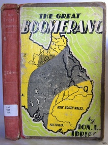
Book - Historical, Australia, The Great Boomerang
... with local indigenous people; thus began his lifelong interest ...This item is from the ‘Pattison Collection’, a collection of books and records that was originally owned by the Warrnambool Mechanics’ Institute, which was founded in Warrnambool in 1853. By 1886 the Warrnambool Mechanics’ Institute (WMI) had grown to have a Library, Museum and Fine Arts Gallery, with a collection of “… choice productions of art, and valuable specimens in almost every branch and many wonderful national curiosities are now to be seen there, including historic relics of the town and district.” It later included a School of Design. Although it was very well patronised, the lack of financial support led the WMI in 1911 to ask the City Council to take it over. In 1935 Ralph Pattison was appointed as City Librarian to establish and organise the Warrnambool Library as it was then called. When the WMI building was pulled down in 1963 a new civic building was erected on the site and the new Warrnambool Library, on behalf of the City Council, took over all the holdings of the WMI. At this time some of the items were separated and identified as the ‘Pattison Collection’, named after Ralph Pattison. Eventually the components of the WMI were distributed from the Warrnambool Library to various places, including the Art Gallery, Historical Society and Flagstaff Hill. Later some were even distributed to other regional branches of Corangamite Regional Library and passed to and fro. It is difficult now to trace just where all of the items have ended up. The books at Flagstaff Hill Maritime Village generally display stamps and markings from Pattison as well as a variety of other institutions including the Mechanics’ Institute itself. RALPH ERIC PATTISON Ralph Eric Pattison was born in Rockhampton, Queensland, in 1891. He married Maude Swan from Warrnambool in 1920 and they set up home in Warrnambool. In 1935 Pattison accepted a position as City Librarian for the Warrnambool City Council. His huge challenge was to make a functional library within two rooms of the Mechanics’ Institute. He tirelessly cleaned, cleared and sorted a disarrayed collection of old books, jars of preserved specimens and other items reserved for exhibition in the city’s museum. He developed and updated the library with a wide variety of books for all tastes, including reference books for students; a difficult task to fulfil during the years following the Depression. He converted all of the lower area of the building into a library, reference room and reading room for members and the public. The books were sorted and stored using a cataloguing and card index system that he had developed himself. He also prepared the upper floor of the building and established the Art Gallery and later the Museum, a place to exhibit the many old relics that had been stored for years for this purpose. One of the treasures he found was a beautiful ancient clock, which he repaired, restored and enjoyed using in his office during the years of his service there. Ralph Pattison was described as “a meticulous gentleman whose punctuality, floorless courtesy and distinctive neat dress were hallmarks of his character, and ‘his’ clock controlled his daily routine, and his opening and closing of the library’s large heavy doors to the minute.” Pattison took leave during 1942 to 1945 to serve in the Royal Australian Navy, Volunteer Reserve as Lieutenant. A few years later he converted one of the Museum’s rooms into a Children’s Library, stocking it with suitable books for the younger generation. This was an instant success. In the 1950’s he had the honour of being appointed to the Victorian Library Board and received more inspiration from the monthly conferences in Melbourne. He was sadly retired in 1959 after over 23 years of service, due to the fact that he had gone over the working age of council officers. However he continued to take a very keen interest in the continual development of the Library until his death in 1969. The Pattison Collection, along with other items at Flagstaff Hill Maritime Village, was originally part of the Warrnambool Mechanics' Institute’s collection. The Warrnambool Mechanics’ Institute Collection is primarily significant in its totality, rather than for the individual objects it contains. Its contents are highly representative of the development of Mechanics' Institute libraries across Australia, particularly Victoria. A diversity of publications and themes has been amassed, and these provide clues to our understanding of the nature of and changes in the reading habits of Victorians from the 1850s to the middle of the 20th century. The collection also highlights the Warrnambool community’s commitment to the Mechanics’ Institute, reading, literacy and learning in the regions, and proves that access to knowledge was not impeded by distance. These items help to provide a more complete picture of our community’s ideals and aspirations. The Warrnambool Mechanics Institute book collection has historical and social significance for its strong association with the Mechanics Institute movement and the important role it played in the intellectual, cultural and social development of people throughout the latter part of the nineteenth century and the early twentieth century. The collection of books is a rare example of an early lending library and its significance is enhanced by the survival of an original collection of many volumes. The Warrnambool Mechanics' Institute’s publication collection is of both local and state significance. About Ion L Idriess Ion Llewellyn Idriess was born in Waverley, Sydney, New South Wales on 20th September 1889 and passed away on 6th June 1979 in Mona Vale, Sydney, New South Wales at the age 89. After Idriess finished school he worked in the assay office of Broken Hill Proprietary mine. Both Idriess and his mother had typhoid fever when Ion was about 15 years old and it caused his mother’s death. After spending time with his Grandmother in Sydney he found work on a paddle-steamer and had a relapse of the fever. He then went into the western district of New South Wales where he worked in many different itinerant jobs, including rabbit poisoner, boundary rider, drover, sandalwood harvester, shearer, dingo shooter and opal miner. While opal mining at Lightning Ridge he wrote short stories, about life on the opal fields, for the Bulletin using the name “Gouger”. Idriess then moved to North Queensland in search of gold, tin and sandalwood. He travelled over a great deal of the Cape York Peninsula spending a lot of this travel time with local indigenous people; thus began his lifelong interest in their customs. He then spent time on cattle stations in the Gulf of Carpentaria. In 1914 Idriess travelled to Townsville and enlisted in the 5th Light Horse as a trooper. He became a specialist in sniping and was a spotter for the noted sniper Billy Sing. He saw service in Palestine, Sinai and Turkey. Idriess was wounded at Beersheba and after fighting the Battle of Gaza he was invalided home in March 1918. After recovering from his wounds Idriess again travelled to Cape York Peninsula where he worked with pearlers and missionaries in the Torres Strait Islands. He then went gold mining in Papua New Guinea, buffalo shooting in the Northern Territory of Australia and then exploring in Central and Western Australia. LITERARY WORKS OF IDRIESS In 1928 Idriess settled in Sydney and published the first of his 47 books. In 1931 - “Lasseter’s Last Ride”, became his first best seller. In the years 1932 and 1940 he published three books in each year. “The Cattle King” (1936) and “Flynn of the Inland” (1932) have gone through reprinting forty to fifty times. His last book was published in 1969. Idriess’ books where in general non-fiction and were written in a colourful and immediate story style, taken from life experiences gained during his travels. Idriess was appointed an Officer of the Most Excellent Order of the British Empire (OBE) for his service to literature in 1968. The Great Boomerang Author: Ion L Idriess Publisher: Angus & Robertson Date: 1948Label on spine cover with typed text PAT 919 IDR Pastedown front endpaper has sticker from Corangamite Regional Library Service warrnambool, shipwrecked-coast, flagstaff-hill, flagstaff-hill-maritime-museum, maritime-museum, shipwreck-coast, flagstaff-hill-maritime-village, shipwrecked-artefact, book, pattison collection, warrnambool library, warrnambool mechanics’ institute, ralph eric pattison, corangamite regional library service, warrnambool city librarian, mechanics’ institute library, victorian library board, warrnambool books and records, warrnambool children’s library, great ocean road, the great boomerang, ion l idriess -
 Merri-bek City Council
Textile - Wool, cotton, on printed cotton, Kait James, It’s Time, 2023
-
 National Wool Museum
Photograph, Dr Christian Thompson AO, House of Gold - Chapter VI, 2023
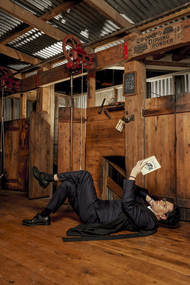
This work is from a series centred around the Chinese proverb “to hold a book in one’s hand is to hold a house of gold” in which the artist positions himself within sites of colonial power. Set within the National Wool Museum gallery, the artist references the pose of an exhausted shearer after a long day of arduous labour. However he is reclining while reading The Fire Stick by Wulla Merrii, a novel set against the 1891 Queensland Shearer’s Strike, questioning cultural stereotypes and how they pertain to concepts of work and leisure. Dressed in sub fusc, his official uniform as an Oxford scholar, Thompson is a defiant intellectual challenging past and continued misperceptions of First Nations people, while embracing both the intersections of his identity and his ancestral heritage. Dr Christian Thompson AO is a Bidjara man of the Kunja Nation with Irish and Chinese heritage. His practice spans across video, photography, sculpture, textiles, performance and sound, evolving through a process of auto – ethnography. While employing various modes of research, he connects his own experience to larger social, political, cultural meanings and understandings. His doctoral research and art practice has had a critical impact on International and Australian art, making global history as one of the first Australian Indigenous students at Oxford University. In 2018 he was made an Officer of the Order of Australia for distinguished services to the visual arts and as a role model to young indigenous artists in the Queen’s Birthday honours list.Framed photograph showing a man dressed in an academic gown, laying on their back holding a book. The setting is a reconstructed shearing shed, inside the galleries of the National Wool Museum.dr christian thompson, first nations, artwork, photography, oxford, heritage, national wool museum -
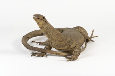 The Beechworth Burke Museum
Animal specimen - Sand Goanna, Trustees of the Australian Museum, 1860-1880
Sand goannas are the second largest species of carnivorous lizards found across mainland Australia. They can grow up to 160cm in length and can weigh as much as 6kg. Their common name is derived from "iguana", since early European bush settlers in Australia likened goannas to the South American lizards. Goannas retain special cultural and historic significance within Australian folklore and Indigenous culture. They were an important traditional native food source and are commonly represented in Aboriginal Dreamtime stories. In some Aboriginal languages, the sand goanna is called "bungarra"; a term also commonly used by non-Aboriginal people in Western Australia. In Pitjantjatjara and other central Australian languages, goannas are called "tingka". This specimen is part of a collection of almost 200 animal specimens that were originally acquired as skins from various institutions across Australia, including the Australian Museum and the National Museum of Victoria, as well as individuals such amateur anthropologist Reynell Eveleigh Johns between 1860-1880. These skins were then mounted by members of the Burke Museum Committee and put-on display in the formal space of the Museum’s original exhibition hall where they continue to be on display. This display of taxidermy mounts initially served to instruct visitors to the Burke Museum of the natural world around them, today it serves as an insight into the collecting habits of the 19th century. This specimen is part of a significant and rare taxidermy mount collection in the Burke Museum. This collection is scientifically and culturally important for reminding us of how science continues to shape our understanding of the modern world. They demonstrate a capacity to hold evidence of how Australia’s fauna history existed in the past and are potentially important for future environmental research. This collection continues to be on display in the Museum and has become a key part to interpreting the collecting habits of the 19th century.Small goanna with a streamlined body and textured scaly skin in different shades of olive and brown. It has a long neck and a long tail which narrows towards the tip. The goanna has four short, stocky legs which meet with large, curled claws. Its mouth is slightly slightly open, and it has two black glass eyes.On tag: BMM / 5892 /taxidermy mount, taxidermy, animalia, burke museum, beechworth, australian museum, skin, reynell eveleigh johns, lizard, goanna, sand goanna, monitor lizard, various gouldii -
 Port Melbourne Historical & Preservation Society
Manual, Terri Janke et al, First Peoples: A Roadmap for Enhancing Indigenous Engagement in Museums and Galleries, 2018
"First Peoples: A Roadmap for Enhancing Indigenous Engagement in Museums and Galleries" Guide prepared by Terri Janke on behalf of AMAGA (Australian Museums and galleries Association), to advise on how best to advance Indigenous engagement and employment in the museums and galleries sector.celebrations fetes and exhibitions, indigenous australians, museums, terri janke, sarah grant, first peoples, australian museums and galleries association (amaga) -
Lakes Entrance Historical Society
Book - Manuscript, Gelantipy Historical Society, Club Terrace, Errinundra, Bendock - History and People, 1993
A brief history of the indigenoussettlers, aboriginals, surveying -
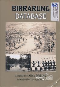 Eltham District Historical Society Inc
Book, Tarcoola Press, Birrarung Database compiled by Mick Woiwod, 2012
A compilation of Woiwod's research material, with information on the history of the Wurundjeri people of the Yarra Valley, from the time of first European contact. Its prime focus is the Yarra River as it has been understood by its Wurundjeri people. Includes a compilation of those difficult to locate "brief snatches of the action" collated under headings with in each instance, the provenance as to source and / or author included. Themes include: agriculture, law, ceremony, language, reconciliation, retribution, lifestyle, art & craft, climate, personalities, disease, death and the river's flora and fauna. Sister publication to "Coranderrk database". 318 pages : illustrations, maps ; 30 cm + 1 CD-ROM (4 3/4 in.) PDF or Microsoft Office Word 97-2003.ISBN 9780987157423wurundjeri, yarra river, indigenous history, wurundjeri woi wurrung, aboriginal australians -
 Geoffrey Kaye Museum of Anaesthetic History
Weapon - Blow pipe, Mah Meri, c. 1936
Used by the Mah Meri people, Kuala Langat, Selangor (Malaysia), 1936. While Malaysian, this blow-gun is analogous to that used by Indigenous groups from South America with curare. The gun is of bamboo, with a highly polished inner tube of the same. The darts are reeds, made directional by knobs of a tudor wood, with poison made from the ipoh tree and the Strychnos vine The blowpipe examined in this report consists of a long bamboo tube with engraved floral motifs on the outside and a second bamboo tube inside. The mouthpiece is attached to the inner tube and the whole piece can be removed from the outer casing. There is a quiver, filled with darts, a small poisons receptacle, and a single dart and hollow bamboo tube, stored outside the quiver. The objects were donated as a whole to the museum in 1948 by Dr Thomas Edward Marshall. The engravings on the outer case originate from the Mah Meri community in Kuala Langat, Selangor, Malaysia. The floral ‘motif is of a vine with small incisions to reflect the properties/identity of the plant (poisonous/harmful)’. These motifs are generally handed down through the generations and can be used for kinship identification. They are also believed to enhance the performance of the blowpipe. The outer casing is made up of several pieces of bamboo fused together. Broken or damaged blowpipes were not discarded. Broken sections of a pipe could be removed and replaced as required, and the observably different bamboo sections suggest this has taken place at some point. Sap from the perah tree is used to seal or glue the pieces together and the glue is reversible by heating. The Mah Meri created a poison from the ipoh tree for use in hunting. The poison acted swiftly to kill the animal and did not result in secondary poisoning. The way in which the Mah Meri hunted is analogous with other blowpipe hunting practices elsewhere in the world. Blowpipe hunting practices represent a starting point for the introduction of standardised muscle relaxants into surgery during the 20th Century. In parts of South America, plant poisons were used to tip the darts and kill prey. These poisons are known as curare. The crucial ingredient in curare was Chondrodendron tomentosum root. Raw curare formed the basis for Intocostrin, the first standardised, mass produced muscle relaxant. The introduction of muscle relaxants dramatically changed surgery, allowing for more precise surgery and better patient outcomes. Bamboo blowpipes can be found in many museum and heritage collections, particularly those with strong colonial origins or influence. Blowpipes from Borneo seem to be well represented, along with those from Guyana. Blowpipes from Malaysia appear to be less common. More research is required to establish the rarity or representativeness of the blowpipe. Ownership of the blowpipe can be traced back from the museum to Dr Thomas Marshall. It has also been established the blowpipe’s point of origin is among the Mah Meri people of Kuala Langat, near Kuala Lumpur. There is no information regarding the way in which Marshall came into possession of the blowpipe. Provenance cannot be fully established. Despite these difficulties, the blowpipe represents a full set of hunting implements. It is accompanied by a quiver, also decorated with a floral motif, a set of bamboo darts, and a poison receptacle. The quiver also has a waist strap which enabled the owner to strap it to themselves, preventing its loss while hunting. Each object within the set is in good condition, although the inner tubing is beginning to split lengthwise and should not be removed from its outer casing. While the blowpipe and accompanying objects are not of South American origin, the techniques and poisons used are analogous and this object has high interpretative capacity. Hollow bamboo blowpipe with mouthpiece at one end. Two different types of organic fibre have been used at difference points along the shaft to secure different segments of the blowpipe. The item consists of two tubes a thin and unpolished inner tube that has degraded and can no longer be removed, and a polished and decorated outer casing. The outer casing is made up of different sections of polished bamboo, some pieces have developed a deep red hue which is likely the result of prolonged polishing and regular heating over many years, other sections are a lighter yellow indicating that they are newer pieces of bamboo. The entire outer tube is covered in a varied sequence of genomic patterns. The exact meaning of these patterns is unknown however they are passed down through family lineage, the exact family of origin is unknown. Connected to the mouthpiece if it is removed from the inner casing is a piece of cloth with the numbers 2241 written in black ink, their purpose is unknown.curare, malaysia, bamboo -
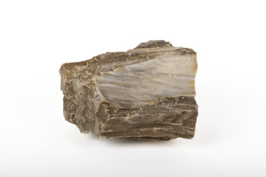 The Beechworth Burke Museum
Geological specimen - Ribbonstone-banded Chert
Chert is a sedimentary rock composed of microcrystalline or cryptocrystalline quartz. While usually biological in origin, chert may also occur as a chemical precipitate or a diagenetic replacement--the product of petrified trees. Chert, also known as flint, was a common tool for early peoples during the stone age. It forms in limestone and chalk sediments as silicon dioxide microcrystals which grow into nodules of chert. Chert is found in many mines across the Northern Territory, however this specimen is sourced from the Mount Todd gold mine in Katherine. Its use in weaponry, both during the Stone Age and during the 18th century. Chert produces a spark when struck against steel, meaning t hat it can be used to start fires and fire guns. Chert was thus used in flintlock firearms, in which the gunpowder is ignited by a flint hammer striking a steel plate. Chert was commonly used in the Stone Age as a result of conchoidal fracturing causing very sharp edges, allowing early peoples to fashion weapons and cutting tools. It also rates a 7 on the Mohs Scale, making it a very hard and durable stone that maintains its sharpness. As a result, the significance of chert as a signifier of early indigenous Australian life makes this specimen important. It is also known that chert is a valuable mineral that was used as a trading commodity. Chert has also been valuable during the 1700s, proving itself to a be an important historical specimen in matters of war. A solid silicon dioxide mineral in shades of brown, white, and beigeburke museum, northern territory, chert, flint, minerals, geological specimen, katherine, mount todd gold mine, katherine northern territory -
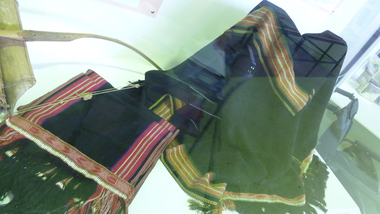 National Vietnam Veterans Museum (NVVM)
Clothing - Montagnard traditional costume
... Montagnard people were the indigenous non-Vietnamese ethnic...Montagnard people were the indigenous non-Vietnamese ethnic ...Montagnard people were the indigenous non-Vietnamese ethnic minorities living in the Central Highlands of Vietnam. Australian Army Captain Barry Petersen was sent to Vietnam in 1963 as part of the elite Australian Army Training Team to train Montagnard rebels in how to deal with the guerrilla tactics used by Viet Cong insurgents. The laplap is an integral part of the traditional ceremonial costume of various Montagnard groups, particularly the Rhade tribe, with whom Petersen lived and worked, learning their language and wearing their traditional clothing.Top and shawl black. Embroidery and weaving in white, red and ocremontagnard, ceremonial costume, laplap, loincloth, petersen, barry petersen, rhade, rade