Showing 44516 items
matching land-conservation-east-gippsland
-
 Kew Historical Society Inc
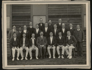
Photograph, 1st X1, Hawthorn East Melbourne Cricket Club, c. 1927
The East Melbourne Cricket Ground was a grass oval sports venue located at the corner of Wellington Parade and Jolimont Parade, in East Melbourne, Victoria, Australia. After the 1921 football season, the ground was closed and then demolished to make way for an extension of the Jolimont Yard railway sidings. In 1921, East Melbourne Cricket Club merged with the Hawthorn Cricket Club, following the loss of the former's ground, to become known as Hawthorn-East Melbourne (or the "Combine"). In 1989, after the club relocated to Glen Waverley, it dropped "East Melbourne" from its title until becoming Hawthorn-Waverley in 1994.Team photo of the Hawthorn East Melbourne Cricket Club, from the collection made by one of its players, Christopher Robinson, pictured middle row, 4th from right. The photo was probably taken at the Glenferrie Oval where the team played. The Club were First Grade Premiers in 1927-28hawthorn east melbourne cricket club, glenferrie oval, cricket, sport, christopher robinson -
 Lakes Entrance Regional Historical Society (operating as Lakes Entrance History Centre & Museum)
Book, LERHS, Vagabond Country East Gippsland, 2010
Contains five articles on different aspects of history Gippsland Victoriatownship, genealogy, fishing industry -
Federation University Historical Collection
Book, Historic Sites Survey: North Central Study Area, 1979, 1979
The North Central Study Area included the Shires of Avoca, Bet Bet, east Loddon, Goulburn, Untly, Kara Kara, Korong, Maldon, Marong, Metcalfe, McIvor, Newstead, Strathfieldsaye, Stawell, Talbot, Clunes, Tullaroop and Waranga. 153 page book with white plastic binding. It is an historic sites survey for the North Central Study Area commissioned by the Land Conservation Council, the Ministry for COnservation and the Australian Heritage Commission. castlemaine, mount alexander goldfield, maldon, percydale, warrenmang, moliagul, tarnagulla, stuart mill, the whipstick, whroo, rushworth, graytown ironbark forest, st arnoaud, new bendigo, landsborough, inglewood, kurting, wedderburn, wehla, kooroora, langham flat, mcintyre, rheola, diamond hill, fosterville, coliban water works, green gully, newstead, muckleford forest, costerfield, graytown, bailieston, waranga irrigaiton system, eucalyptus distillery, mia mia bridge, korokubeal township researce, concegella slate quarry, chewton, fryerstown, kingower, timor, talbot, majorca, carisbroook, clunes, st arnaud, taradale, icomos, dunolly, limestone, castlemaine slate quarry, harcourt granite, taradale railway viaduct, loddon united waterworks trust, gouldburn weir, carisbrook lock-up, history of tree planting in streets, history of public reserves, r.u. nicholls nurseryman, thomas lang, francis moss, ballarat botanical gardens, ballarat school of mines botanical gardens, lake wendouree, victoria park, ballarat, muont holled smith, ballaarat old cemetery planting, eastern oval, ballarat east botanical gardens, ballarat east town hall gardens, eureka stockade reserve, ballarat observatory plantings, yarrowee creek plantings, yarrowee bluestone channels, ballarat woollen mill, band and albion mullock heap, black hill plantings, yarrowee creek channels, canadian creek channel, specimen vale channel, poverty point reserve, union jack reserve buninyong, imperial mine, buninyong, victoria street plantings, bridge mall, sturt street gardens, ballarat avenue of honour plantings, white flat oval plantings, camp street, elms, burnt creek -
University of Melbourne, Burnley Campus Archives
Journal - Journal Extract, Melbourne School of Land and Environment, Land & Environment, Summer 2013
150th celebrations, burnley gardens -
 Latrobe Regional Gallery
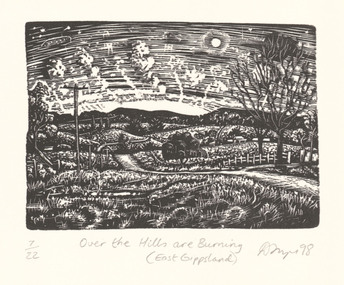
Print, FRAZER, David b. 1966 Foster, Victoria, Over the hills are burning (East Gippsland), 1998
Wood engravingSigned and dated 'D Frazer 98' lower right corner under printed image. Titled 'Over the Hills are Burning (East Gippsland)' centred below print. Edition 7/22, lower left corner under printed image. -
 Greensborough Historical Society
Leaflet, North East Link, 2018
Information about various aspects and designs of the proposed North East Link particularly around the Watsonia areaMiscellaneous leafletsnorth east link, watsonia -
Ringwood and District Historical Society
Work on paper - Letter, Letter from W. Meyland to Mr. Hookey re land in East Ringwood for school. 1969, 22-Jul-69
2-page letter from W. Meyland to Mr. Hookey re land in East Ringwood. School was opened 6-Aug-1924 by Mrs. Everard. +Additional Keywords: Meyland, Charles / Hookey / Lindsay, Ted. -
 Ringwood and District Historical Society
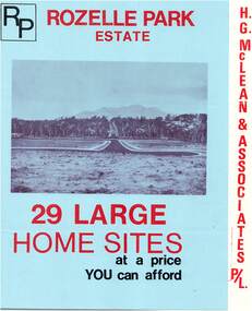
Flyer, Subdivisional Land Sale Brochure, Rozelle Park Estate, Ringwood East, Vic. - circa 1968
Folded land subdivision sale advertisement for 29 home sites, with location map and summary of local facilities and services. Separate price list leaflet enclosed with terms of sale.Subdivision includes Wingate Avenue and Rozelle Avenue, Ringwood East. Agent - H.G. McLean & Associates Pty. Ltd., 166 Canterbury Road, Heathmont. Phone 870 3422 A/H 870 5879. -
 Orbost & District Historical Society
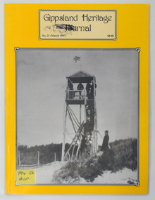
journal, Gippsland Heritage Journal, September 1997
This magazine was edited by Meredith Fletcher.This item is a useful reference for the history of Gippsland.A 64 pp magazine, titled Gippsland Heritage Journal. The front cover is yellow with a b/w photograph of a lookout made of ti-tree at Ocean Grange. The magazine is covered in plastic and is dated March 1997. It cost $8.00.On the outside back cover is a library barcode. On the front is a call no. 994.56 GIPgippsland-heritage-journal history-gippsland -
Greensborough Historical Society
Document - List, Peter Simmenauer et al, Hobson land sales
2 p. list of land sales, with 2 p. copy of LP11599, Vol. 2340 Fol.805subdivision plans, greensborough -
Lakes Entrance Regional Historical Society (operating as Lakes Entrance History Centre & Museum)
Book, Farming in East Gippsland Past present and Future, 1983
A facsimile reprint of Middleton and Mannings Gippsland Directory for 1884 to 1885, covering businesses and residents in the towns.directories -
 Federation University Historical Collection
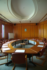
Photograph - Photograph - colour, Clare Kathleen Gervasoni, Federation University Gippsland Council Room, 2013, 29/10/2013
The campus at Churchill became a part of Federation University Australia on 01 January 2014. Federation University Australia was established on 1 January 2014. Formerly known as the University of Ballarat, its enabling legislation was the University of Ballarat Amendment (Federation University Australia) Act 2013. Although formally created as a University in 1994, the University of Ballarat had a lineage back to 1870 with the establishment of the School of Mines Ballarat, making it the third institution of higher learning to be established in Australia and the first to be established in regional Australia. On 1 January 1994, Ballarat University College became the University of Ballarat and in 1998 the University merged with three TAFE Institutes to become a dual sector institution with multiple campuses. On 1 January 2014, the University of Ballarat amalgamated with the Monash University Gippsland Campus to form Federation University Australia. The Gippsland Campus also had a long lineage dating back to 1928 with the establishment of the Yallourn Technical School which became a predecessor institution to the Gippsland College of Advanced Education formed in 1968. In 1990, it was renamed the Monash University College and in 1993 became the Gippsland Campus of Monash University. Federation University Australia, or FedUni, is Australia’s newest public University. Headquartered in Ballarat, Victoria, the University offers programs in Higher Education and Vocational Education and Training to regional Victoria and beyond. The University’s commitment to educational and social equity, teaching excellence, research distinction, environmental sustainability and regional capacity building has enabled it to develop in a way that draws on its proud heritage to inform its future. Its regional character sets a framework for the University’s priorities but does not constrain it from serving wider community interests, nationally and internationally. With campuses from Horsham in the west of the state, to Churchill in the east, the name Federation University Australia was chosen to convey the scope and capacity of an expanded regional university with a federated network of campuses contributing to a new and different Australian university.Photograph of a timber lined Council Room at Federation University Gippsland campus. This campus was formerly a campus of Monash University, and their logo has not been removed from thr wall in this photograph.federation university, gippsland campus, monash university, churchill, gippsland, board room, council room, gippsland campus collection -
 Kew Historical Society Inc
Photograph - Victorian Canoe Club, Gippsland Lakes, 1935
Canoeing on the River Yarra at Melbourne was an important and widespread recreational pursuit for Melbournians, especially in the first half of the twentieth century. The Victorian Canoe Club was formed in 1912 at a meeting in Melbourne and its first committee elected in the same year. Records indicate that the Club continued into at least the 1950s .The photos in this album are historically and socially significant as a record of recreational activities in the first half of the twentieth century. A number of photographs in the album provide views of sections of the Yarra, as well as areas in regional Victoria, that may otherwise be unavailable.One of 12 sepia [faded] photographs of members of the Victorian Canoe Club. This photo was taken by a member of the club on a later trip to the Gippsland Lakes and Mallacoota in 1935."Gippsland Lakes"victorian canoe club, travel -- 1930s, gippsland lakes -
 Orbost & District Historical Society
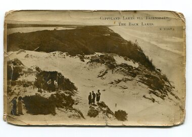
black and white photograph, Vogt, Stanley, first half 20th century
Back Lake track is near Metung, East Gippsland.This is a pictorial record of the Gippsland Lakes in the early 20th century.A black / white postcard photograph of a beach scene. Small groups of people are standing on a vegetated sand dune overlooking the water. on front - " Gippsland Lakes via Bairnsdale - the Back Lakes, S. Vogt"gippsland-lakes back-lake-bairnsdale -
 Nhill & District Historical Society Inc.
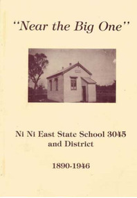
Book - Near the Big One, Graham Schultz, Ni Ni East State School 3045 and District 1890-1946, 1994
History of the Ni Ni East State School 3045 and families in the district from 1890 to 1946Near the Big One; Ni Ni East State School 3045 and District 1890-1946. Soft cream-colored cover, with a picture of the Ni Ni East State School on front. Written and published by the Ni Ni East Reunion Committee, in 1994; 89 pagesnon-fictionHistory of the Ni Ni East State School 3045 and families in the district from 1890 to 1946ni ni east - history, ni ni east state school, australian history, education, rural life -
Lakes Entrance Regional Historical Society (operating as Lakes Entrance History Centre & Museum)
Book, Glover, Barbara, East Gippsland Victoria, 1978
A tourism information booklet depicting the rich variety and many attractions of the Gippsland Lakes, Victoria. Illustrated with colour photographs and a map of the region.waterways, township, tourism -
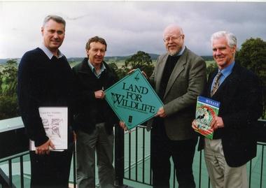 Federation University Historical Collection
Photograph, Gippsland Institute of Advanced Education Campus Land for Wildlife, c2000
Four men stand holding a Land for Wildlife sign. Left to right: Anton Wray, DNRE Representative, B. McKenzie (PUC), Ron Dickson, Science. If you can assist with infrormation on this photograph please use the email link below. gippsland campus collection, gippsland institute of advanced education, anton wray, ron dickson, b. mckenzie -
 Orbost & District Historical Society
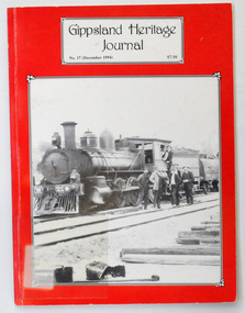
journals, E-Gee Printers, Gippsland Heritage Journal, December 1994
This magazine was edited by Meredith Fletcher.This journal is a useful reference for the history of the Bairnsdale to Orbost Railway. Two copies of a 64 pp magazine, titled Gippsland Heritage Journal. It has a red cover with a b/w photograph of a special train taking workers to Melbourne for a Christmas break c 1915. The journal is No 17, December 1994 and cost $7.50. It contains an article , "Tent Life on the Orbost Line" with photographs and history of the Bairnsdale - Orbost railway line.2426.1 has a call no. on front cover 994.56 and a bar code on the back cover GIP journal-gippsland-heritage-journal history-railway -
Lakes Entrance Regional Historical Society (operating as Lakes Entrance History Centre & Museum)
Book, Love Don, East Gippsland Shire: Heritage Gaps Study Vol.3, 2015
A list of boating accidents which have occurred in the Gippsland Lakes and nearby coast, highlighting the dangers faced by mariners from late 1700 to 1999boats and boating, trades -
 Orbost & District Historical Society
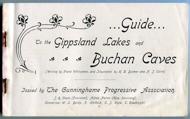
Book, The Cunninghame Progressive Association, Guide to Buchan Caves & the Gippsland Lakes, c.1900-1910
This booklet was issued as a tourist advertising/promotion for the Gippsland Lakes and Buchan Caves. It was most likely printed in the early 20th Century. This promotion also includes associated areas such as Lake Tyers, Cunninghame (Lakes Entrance), Nowa Nowa, Sale, and Bairnsdale. An early tourist promotion for East Gippsland, focussing on Melbourne tourists travelling to Sale or Bairnsdale by train, and then by steamer or coach. An example of an early tourism promotion.A booklet of 103 pages, printed in b/w. The cover is a dk. red paper with gold print, quite fragile. The book contains b/w photographs, advertisements, time tables for trains and steamers travelling through the Gippsland Lakes from Sale to Cunninghame (eg. SS JCD), also a map of the steamer route. ...Guide... To the Gippsland Lakes and Buchan Caves (Written by Frank Whitcombe, and Illustrated by H D Bulmer and N J Caire). Issued by The Cunninghame Progressive Association. J R Coate (President), Alfred Nation (Hon. Secretary), Committee - W S Barke, P Harbeck, E J Wyld, T Roadknightbuchan caves, gippsland lakes, ss j c d, tourism -
Bendigo Historical Society Inc.
Book - REPORT ON THE NORTH CENTRAL STUDY AREA OF VICTORIA
252 page Report on the North Central Study Area by the Land Conservation Council of Victoria - July 1978 Illustrated with B&W photos Back section contains several removeable maps. Printed by F D Atkinson, Government Printer, MelbourneLand Conservation Council, Victoria -
 Lakes Entrance Regional Historical Society (operating as Lakes Entrance History Centre & Museum)
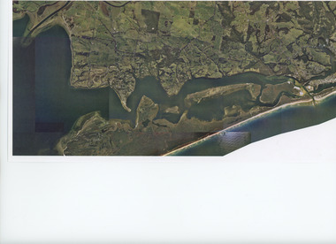
Photograph - Lakes Entrance, Gippsland Ports, 2006 c
Colour aerial photograph showing the entrance to Gippsland Lakes from Bass Strait westward to Reeves Channel Shaving Point at Metung through Lake King to Tambo River Gippsland Lakes Victoriaaerial photograph, waterways, township, topography, lakes entrance -
Clunes Museum
Education kit - DOCUMENT, SOIL CONSERVATION AUTHORITY, MCHUGH'S GULLY - A LAND USE AND MANAGEMENT TEACHING RESOURCE KIT, 1982
ENVIRONMENTAL STUDY OF MCHUGH'S GULLY RECORDED IN THE EARLY 1980'SBUFF COLOURED LEVER ARCH FILE CONTAINING SECTIONS A TO I WITH A CARDBOARD INSERT OF FRONT COVER WITH SEPIA IMAGES OF RURAL SCENES AND TOWN SHIP PRINTED ON IT. Section A contains documents of land use and management teaching resource kit. Section I contains slides and transparenciesnon-fictionENVIRONMENTAL STUDY OF MCHUGH'S GULLY RECORDED IN THE EARLY 1980'Smchughs gully, land management, environmental impact report -
Clunes Museum
Document - REPORT, NADIA GASPARETTO et al, CLUNES TOWN HALL AND COURT HOUSE CONSERVATION PLAN, MAY 2000
THE HISTORY AND CONSERVATION POLICY IS AIMED AT RETAINING AND CONSERVING THE BUILDINGCONSERVATION PLAN OF CLUNES TOWN HALL AND COURT HOUSE COMPILED BY NADIA GASPARELTO , ARCHITECT AND HEPBURN SHIRE COUNCIL, INCLUDING PLAN OF BUILDINGLIST OF ILLUSTRATIONS AND PHOTOSclunes town hall, clunes courthouse -
Lakes Entrance Regional Historical Society (operating as Lakes Entrance History Centre & Museum)
Album, M Fish
Many copied from publications of Bairnsdale, Metung, Lakes Entrance, Lake TyersRed folder containing images of East Gippsland settlements and activities East Gippsland Victoriawaterways, township, ships and shipping -
Federation University Historical Collection
Booklet, Michael Taffe, Beaufort House Ballarat Conservation Plan, 2004
Michael Taffe undertook this Conservation Pan while completing an Bachelor of Arts (Honours) at the University of Melbourne in 2004.Forty five page conservation management plan for Beaufort House. Includes: * Dowling Forest Paris Plan * Plan of Drainagebeaufort house, student residences, student accomodation, certificate of title, dowling forest, henry cuthbert, archibald mckay, max mckay, beaufort street, cardigan street, stables, charles davernport cuthbert -
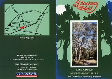 Ringwood and District Historical Society
Flyer, Land Auction Brochure - Thackray Wood, Ringwood East - circa 1984
Double sided bi-fold sales brochure regarding sale of 14 blocks of land comprising Thackray Wood, corner Cheong Street and Ruthven Way, Ringwood East. Agent: Max Brown Real Estate, 53 Main Street Croydon, Tel 7230281 a.h. 8764034. Inset image of additional copy with handwritten sale prices. -
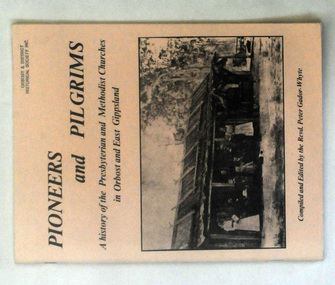 Orbost & District Historical Society
books, Pioneers and Pilgrims, 1986
Rev Peter Gador-Whyte's first UCA Parish was at Orbost in East Gippsland.This is a local history book useful for research and written by a local.Two copies of a 76 pp book titled Pioneers and Pilgrims a history of the Presbyterian and Methodist Churches in Orbost and East Gippsland. The front cover is buff coloured and has a b/w photograph of a group of people standing outside a hut with a bark roof. On the right hand side is a man on a horse. The book was compiled and edited by the Revd Peter Gador-Whyte.2178.2 - Ruth Leggechurch-history presbyterian-methodist-orbost -
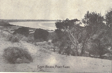 Port Fairy Historical Society Museum and Archives
Photograph, East Beach, Port Fairy
Black and white photograph of East beach with post and rail fenceEast Beach, Port Fairybeach, sea, seascape, east beach, battery hill -
 Orbost & District Historical Society
plan, before 1948
Drainage infrastructure was developed and maintained in this region by the Snowy River Improvement Trust. The Trust was administered by a local committee and its activities funded by a local rate charged on the farmers and land owners in the Trust’s designated district. The level of the rate charged by the Trust was designed to be proportionate to the benefit derived from the works undertaken. Financial assistance was provided by the State Government from time to time for specific projects such as post flood repairs but not for new capital works. The Trust undertook new drainage and river management works including tree planting, rock beach construction and servicing of the drains and flood gates. The Trust also provided a personal flood warning service to the farmers in its district. The Trust ceased to operate in 1997 with the advent of the East Gippsland Catchment Management Authority. The infrastructure developed by the Trust continues to provide a service to the farmers in the region. (ref. 4 East Gippsland CMA Submission to Inquiry into Flood Mitigation Infrastructure in Victoria) This plan is significant as a historical document. The Snowy River Improvement Trust was vital to the Orbost district because of its ability to apply local knowledge and to engage the local farming community.A large plan of divisions of land for the purpose of levying the Snowy River Improvement District - Bete Bolong, Orbost, Waygara, Newmerella and Orbost East. The properties are coloured according to levy amount. The scale is 1" - 20 chains. snowy-river-improvement-trust