Showing 441 items
matching lands, victoria
-
 St Kilda Historical Society
Photograph - Photo map, 11/01/1968
One of a series of photo-maps produced for the Department of Crown Lands and Survey (1857-1983). For correlation with a current map, and access to other historical photo maps of Victoria, see the Historic Photo-Maps Index published by the Department of Environment, Land, Water and Planning at https://services.land.vic.gov.au/DELWPmaps/historical-photomaps/Black and white aerial photographVic 2132 State Aerial Survey Melbourne 1968 Proj. Run 27E 11.1.68 5100 ASL 69st kilda, albert park, st kilda east, st kilda beach, alma park, windsor, prahran, 1968 -
 St Kilda Historical Society
Photograph - Photo map, 11/01/1968
One of a series of photo-maps produced for the Department of Crown Lands and Survey (1857-1983). For correlation with a current map, and access to other historical photo maps of Victoria, see the Historic Photo-Maps Index published by the Department of Environment, Land, Water and Planning at https://services.land.vic.gov.au/DELWPmaps/historical-photomaps/Black and white aerial photographVic 2132 State Aerial Survey Melbourne 1968 Proj. Run 28E 11.1.68 5100 ASL 81st kilda, balaclava, st kilda east, ripponlea, elwood, elsternwick, caulfield, st kilda botanical gardens, 1968 -
 St Kilda Historical Society
Photograph - Photo map, 11/01/1968
One of a series of photo-maps produced for the Department of Crown Lands and Survey (1857-1983). For correlation with a current map, and access to other historical photo maps of Victoria, see the Historic Photo-Maps Index published by the Department of Environment, Land, Water and Planning at https://services.land.vic.gov.au/DELWPmaps/historical-photomaps/Black and white aerial photographVic 2132 State Aerial Survey Melbourne 1968 Proj. Run 29E 11.1.68 5100 ASL 194elwood, elwood beach, elwood park, elsternwick park, ripponlea, elwood canal, balaclava, st kilda, 1968 -
 St Kilda Historical Society
Photograph - Photo map, 11/01/1968
One of a series of photo-maps produced for the Department of Crown Lands and Survey (1857-1983). For correlation with a current map, and access to other historical photo maps of Victoria, see the Historic Photo-Maps Index published by the Department of Environment, Land, Water and Planning at https://services.land.vic.gov.au/DELWPmaps/historical-photomaps/Black and white aerial photographVic 2132 State Aerial Survey Melbourne 1968 Proj. Run 27E 11.1.68 5100 ASLst kilda, st kilda west, st kilda pier, catani gardens, st kilda beach, albert park, 1968 -
 St Kilda Historical Society
Photograph - Photo map, 11/01/1968
One of a series of photo-maps produced for the Department of Crown Lands and Survey (1857-1983). For correlation with a current map, and access to other historical photo maps of Victoria, see the Historic Photo-Maps Index published by the Department of Environment, Land, Water and Planning at https://services.land.vic.gov.au/DELWPmaps/historical-photomaps/Black and white aerial photographVic 2132 State Aerial Survey Melbourne 1968 Proj. Run 29E 11.1.68 5100 ASL 196elwood, elwood park, elwood canal, elwood beach, st kilda marina, mc moran reserve, point ormond, 1968 -
 St Kilda Historical Society
Photograph - Photo map, 14/12/1963
One of a series of photo-maps produced for the Department of Crown Lands and Survey (1857-1983). For correlation with a current map, and access to other historical photo maps of Victoria, see the Historic Photo-Maps Index published by the Department of Environment, Land, Water and Planning at https://services.land.vic.gov.au/DELWPmaps/historical-photomaps/Black and white aerial photographVic 1807 Melbourne 1963 Project Run 17 14.12.63 Lens 205 152.70 M/M 5.150 36st kilda, st kilda botanical gardens, balaclava, st kilda east, elwood canal, ripponlea, caulfield north, elwood, caulfield, 1963 -
 St Kilda Historical Society
Photograph - Photo map, 14/12/1963
One of a series of photo-maps produced for the Department of Crown Lands and Survey (1857-1983). For correlation with a current map, and access to other historical photo maps of Victoria, see the Historic Photo-Maps Index published by the Department of Environment, Land, Water and Planning at https://services.land.vic.gov.au/DELWPmaps/historical-photomaps/Black and white aerial photographVic 1807 Melbourne 1963 Project Run 16 14.12.1963 Lens 205 152.70 M/M 5.150 177st kilda, st kilda pier, catani gardens, middle park, albert park, st kilda west, st kilda beach, 1963 -
 Tatura Irrigation & Wartime Camps Museum
Book, Register of Lands, 1984
... . Black lettering, SR & WSC Victoria, Register of Lands, Rodney... Tatura the-murray Register of Lands in Tatura district regarding ...Register of Lands in Tatura district regarding annual water rights for farms 1983-84Grey back cover, pale green front cover, blue cloth spine. Black lettering, SR & WSC Victoria, Register of Lands, Rodney Irrigation area of Goulburn Murray Irrigation District. 1983-84 Irrigation Seasonfarming, irrigation, books, rural, industry -
 Victorian Aboriginal Corporation for Languages
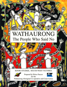
Book, Bruce Pascoe et al, Wathaurong : the people who said no, 2003
The Wathaurong people of South Western Victoria said no to European invasion. Learn about this heroic resistance to the occupation of their lands. Can white and black live together or must we be always at war? The answer can only be given by young Australians. Includes a comprehensive historical timeline.maps, colour illustrations, b&w illustrations, colour photographs, word listswathaurong, wadtharung, port philllip bay, western port bay, lorne, south west victoria, battle creek, aire river, werribee, ballarat, wathaurong aboriginal cooperative, coast action, koori studies, john batman, william buckley, aboriginal studies policy, secondary school education, hissing swan, victorian history -
 Victorian Aboriginal Corporation for Languages
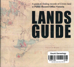
CD-ROM, Public Record Office Victoria, Lands guide : a guide to finding records of Crown land at Public Record Office Victoria, 2009
... of Crown land at Public Records Office Victoria. Lands guide ...A Guide to finding records of Crown land at Public Records Office Victoria.CD-ROM -
University of Melbourne, Burnley Campus Archives
Article - Photocopy, Horticultural Society of Victoria, 1860
Photocopy of Newspaper Article, Thursday 2 August, 1860 p 7 Report of the monthly meeting of the HSV Municipal Council of Richmond and commissioner of Public Works had granted funds for fencing the gardens and plans for a special meeting as soon as the Department of Lands had granted them land in the Surrey Paddock.Newspaper article from The Argusthe argus, surrey paddock, burnley gardens, horticultural society of victoria, hsv -
University of Melbourne, Burnley Campus Archives
Document - Circular, Department of Crown Lands and Survey. Complete list of weeds declared noxious in the State of Victoria, 1964-1972
Chart prepared by Vermin and Noxious Weeds branch. Plants proclaimed under the Noxious Weeds Act 1928 (No 3799) for the State of Victoria.. Plants proclaimed within certain Municipalities of Victoria. Includes tables of Chemical Treatment and other remarks.Large circular - Complete list of weeds proclaimed noxious within the State of Victoria and for certain Municipalities and table of quantities for chemical treatment together with brief instructions for treatment of Noxious Weeds (Vermin and Noxious Weeds Act 1928)weeds, vermin and noxious weeds act 1928, chemical treatment of weeds -
 Chiltern Athenaeum Trust
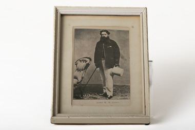
Photograph, JUDGE W. H. GAUNT
This photograph is a copy displayed in the Australian Dictionary of Biography. The original photograph is in the La Trobe Collection in the State Library of Victoria. William Henry Gaunt (1830-1905), judge, was born on 27 July 1830 at Leek, Staffordshire, England, son of John Gaunt, banker, and his wife Mary, née Bakewell. Educated at Leek Grammar School and Whitchurch, Salop, he migrated to Melbourne, and entered the Victorian public service and was rapidly promoted. By March 1854 he was chief clerk at Beechworth, the administrative centre of the Ovens goldfield. In July 1855 the resident warden commended Gaunt as 'a highly valuable public servant' with an intimate knowledge of the district and the 'temper and disposition of the miners'. Appointed sub-warden in the Beechworth district in January 1856 and a Chinese protector in August, he was given control of the extensive Woolshed district. When European miners attacked a party of Chinese at the Buckland River diggings in May 1857 Gaunt was sent to restore order. One of his proclamations, issued in Chinese characters, concluded 'W. H. Gaunt, your protector—tremble and obey!' In June he was appointed a police magistrate and next month was sent to take charge at the Buckland where the Chinese had been expelled from the diggings; the police force assisting him was led by Robert O'Hara Burke. In January 1858 Gaunt was appointed a warden, in November was transferred to Chiltern, north of Beechworth, and in August 1859 was made a commissioner of crown lands. In February 1860 Gaunt was appointed a coroner of Victoria, acting at Indigo, near Chiltern. In April 1865 he was transferred to Beechworth, became visiting justice of the gaol and later moved to Sandhurst. In January 1869 he was appointed returning officer for the mining district of Ballarat and visiting justice of the gaol. He was associated with this area for the rest of his life and won high repute for his integrity. In 1874 he chaired the inaugural meeting of the first Australian competitive swimming club. For years he studied law and was called to the Bar in December 1873. He was one of the many public servants dismissed by Graham Berry on 9 January 1878 (Black Wednesday). After petitioning the Queen in vain over his dismissal he began practice in Ballarat as a barrister. He soon became a leading authority on mining laws; one of the cases in which he was involved was the lengthy inquest on the bodies of the twenty-two miners drowned in the New Australasian mine disaster at Creswick in 1882. He was appointed a temporary judge of the Insolvency Court in 1889 and a County Court judge in 1891. In 1900 he was chairman of the royal commission which considered Metropolitan Board of Works matters, and in 1902 was president of the inquiry into the unification of municipalities in Victoria. In 1860 Gaunt married Elizabeth Mary, the youngest daughter of Frederick Palmer; they had nine children. Of the surviving five sons and two daughters, Ernest Frederick Augustus and Guy Reginald Archer both became admirals and were knighted; Cecil Robert became a lieutenant-colonel, Clive Herbert a government advocate in Rangoon and Mary (Mrs H. L. Miller) one of the first women students to enrol at the University of Melbourne (1881), although she did not complete her degree; she became a successful novelist. Gaunt died on 5 October 1905. An anonymous colleague said: 'I don't think he was ever excelled as a police magistrate, and during the many years he was on the County Court bench he earned the highest regard. His capacities were as unquestioned as his integrity, and more could not be said of any judge'. Select Bibliography Votes and Proceedings (Legislative Assembly, Victoria), 1878, 3, (58) Government Gazette (Victoria), 22 Feb, 15 Aug 1856, 30 June 1857, 5 Jan 1858, 16 Aug 1859, 3 Feb 1860, 7 Mar, 11 Oct 1862, 28 Mar, 4 Apr 1865, 17 May 1867, 9 June 1868, 22, 29 Jan 1869 Ovens and Murray Advertiser, 21 May 1857, 11 Mar 1865 Colonial Secretary's in-letters, goldfields, 25 Mar 1854, 21 July, 18 Nov 1855, 22 Aug 1857 (Public Record Office Victoria) scrapbook and newsclippings (privately held). Related Entries in NCB Sitesview family tree Gaunt, Mary Eliza (daughter)go to ADB entryPhotograph of Judge W. H. Gaunt standing beside chair holding top hat and cane, under glass, in cream frame with cream matte.Printed name underneath: JUDGE W. H. GAUNT -
 Nillumbik Shire Council
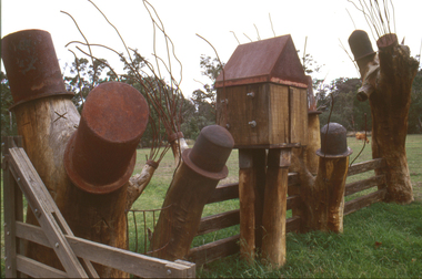
Sculpture: Tony Trembath (b.1946 Sale, Victoria), Tony Trembath, The Fences Act 1968 - Location: Edendale Farm (entrance) 30 Gastons Road, Eltham, 1989 - 1994
Eltham Council (now the Shire of Nillumbik) commissioned this work in 1989 to create an entrance / gateway to Edendale Community Farm. It was also aided by a grant from the Ministry of the Arts (now Arts Victoria). The former name of this work was "Gateway to Edendale Farm". Edendale Farm is a demonstration farm modelling sustainable environmental practices, providing support to the local residents of Nillumbik. Established in 1986, the land was purchased in 1970. It was previously an English gentleman's residence and was used for grazing. It consists of 5.6 hectares, with the Diamond Creek meandering through the property. The Victorian Fences Act 1968 governs liability of occupiers of adjoining lands to fence, and deals with disputes between neighbours regarding boundaries fences and costs. This work took into consideration ideas and suggestions from residents and committees, who required the use of recycled materials and that the work celebrate man's relationship with nature, animals and the earth, as well as relate to the fence-line on the far side of the carpark. Trembath also absorbed significant aspects of local history, making references to Eltham's agricultural past, the clearing of the land, the destruction of trees, the ruthless pruning of trees by suburban Councils and incorporated such Australian features as the post and rail fence. 'The Fences Act 1968' is significant for aesthetic, historic and social reasons at a regional level. It makes prominent the historical and social significance of Edendale and the rural aspects of Nillumbik. The use of existing tree stumps and salt pots in the work explores the iconography of the countryside such as the isolated farmhouse, pioneering farming practices, post and rail fencing and the regrowth of lopped trees. The title of the work, as well as the extensive community involvement in its creation, also makes reference to the Victorian Fences Act 1968, which makes neighbours jointly responsible for the cost of construction and maintenance of fences in the partitioning of land for settlement. 'The Fences Act 1968' has been classified as of regional significance by the National Trust of Australia. The work is an installation of wood and metal, approximately twenty five meters long. The design is very informal and rustic and runs the full width of the fence-line. It comprises groups of recycled tree trunks fitted with metal caps (chrome-nickel 'salt pots' that are shaped like tall bowler / top hats). Metal rods protrude from the trunks and some of these rods have metal birds. Two larger, sentinel-like stumps at the two outer ends have metal flame-like wings, which bend inward. To the left of the entrance, a simple architectural element indicates an isolated farmhouse. The rustic fence runs between the groups of tree trunks with native planting in clumps along it. The fence-line incorporates a functional engineered double gate and post and rail fencing. There may be many interpretations of the work and the intention is to stimulate interest and imagination rather than alienate. Interpretation is based on the personal experience that a visitor brings. The artist recommended that no explanation of the design logic be positioned with the work. N/Apublic art, sculpture, edendale, recycled, wood, metal, fences act 1968, gate, trembath, salt pot, tree stumps -
Stawell Historical Society Inc
Map, Easton Johnstone, Map of Stawell Surveyed by Easton Johnstone 1872, 1872
Victoria Co Crushing Machine. St Georges Co Crushing machine. Wimmera Co Crushing Machine. Government Reservoir and Drainage. Sloan Street, Skene Street Mines. old Mine WorkingsA2 map of Stawell Reefs Area. Showing Crushing Machines & Title InfoSurveyed by Easton Johnstone Contract Surveyor. Photo-Lithographed at the Department of Lands & Survey. Melbourne By J Noone 9th May 1872mining -
Stawell Historical Society Inc
Map, Department of Lands and Survey, Borough of Stawell. Parishes of Stawell and Illawarra 1903, 1903
Victoria Co., St Georges Co., Wimerra Co., Leviathon Co. Tramway, Quarry reserve, Newington Co., Galatea Co., Moonlight Co., Federal Co., Borough reservior., A0 Map of Stawell on linen backing. Plus one Printed on PaperPhoto Lithograped at the Department of Lands and survey Melbourne by T.F. McGauran 13.6.03surevy -
Stawell Historical Society Inc
Book - Report, Grampians National Park Draft Management Plan, 1985
For Public comment to National Park Service, Victoria. A Division of the department of Conservation, Forest and LandsSoft Cover with B/W Photo of aerial view of ranges of Grampians. Black taped Spine binding.$5 Barry Clugston -
 Stawell Historical Society Inc
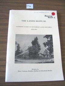
Book, Peter Cabena, Heather McRae & ElizabethBladin, The Lands Manual - A Finding guide to Victorias Lands Records 1836-1983, 1989
... wooden buildings The Lands Manual - A Finding guide to Victorias ...The Purpose of this manual is to describe the documentary archives of the Department of Crown Lands and Survey (Lands Department) and Explain, how they can be used for historical researchYellow card Cover Black Print and B/W Photo of two wooden buildings The Lands Manual A Finding guide to Victorian Lands Records 1836-1983 Written by Peter Cabena, Heather McRae & Elizabeth Baldinstawell -
 Stawell Historical Society Inc
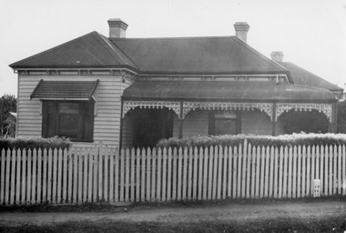
Photograph, Albert Davey, 20 Sloane Street Stawell 1950
Home 20 Sloane Street Stawell taken in 1950 by Albert Davey who resided there with his family. House has three chimneys bull nose verandah with cast iron lacework, weatherboard construction with picket fence. Albert (Bert) worked for the Lands Department and his family consisted of 4 girls oldest being Aubrey about 18, Beverley about 16, Gwenda about 14 and the baby Faye about 4. and Alberts wife Phyllis. Albert worked all over Victoria from Buchan where they lived in the Caves Residence for 6 months, in Omeo, Yackandandah, Stawell, Wangaratta and Shepperton and then Melbourne where he took on the top job of Chief Superintendent of the Lands Dept. Now, 2018 uses as a cottage for distributing food by Inter Church CouncilResidence 20 Sloane Street Stawell housing -
Koorie Heritage Trust
Book, Burnum Burnum, Burnum Burnum's Aboriginal Australia : a traveller's guide, 1988
... -- Guidebooks. | Burnum Burnum Foreword | Victoria - Aboriginal lands... | Victoria - Aboriginal lands history. This unique book takes ...This unique book takes the reader on a journey around the continent, an unforgettable journey that reveals an Australia rarely experienced by its white inhabitants.328 p. : ill., map, ports. ; 31 cm.This unique book takes the reader on a journey around the continent, an unforgettable journey that reveals an Australia rarely experienced by its white inhabitants. aboriginal australians -- history. | australia -- guidebooks. | burnum burnum foreword | victoria - aboriginal lands history. -
Koorie Heritage Trust
Book, Brown, Anne, Wotjobaluk Dreaming: a case study of the Wotjobaluk People and their Country, 2001
This study examines a number of Aboriginal and Natural Places listed on the Natioonal Estate Register for the Wimmera and Southern Mallee Districts of Victoria. These are the traditional lands of the Wotjobaluk people. Their descendantssee these sites as a vital partof their culltural heritage and along with government agencies are actively involved in preservation and management issues.i-xii-Pp 253; illus; appendices; figs.; maps; 30 cm.This study examines a number of Aboriginal and Natural Places listed on the Natioonal Estate Register for the Wimmera and Southern Mallee Districts of Victoria. These are the traditional lands of the Wotjobaluk people. Their descendantssee these sites as a vital partof their culltural heritage and along with government agencies are actively involved in preservation and management issues.wotjobaluk people history - lifestyle -, wimmera-aboriginal sites, southern mallee - aboriginal sites, ebenezer mission - history, aboriginal protection board - parliamentary reports, native title-wotjobaluk people. -
Koorie Heritage Trust
Journal - Serials, Aborigines Advancement League, Smoke Signals, 1970
... -Victoria- Aboriginal Lands Act Bill-1970-Parliamentary ...Articles on current events of the period from an Aboriginal point of view. Land Ownership, Victoria-Aboriginals-Lake Tyers, Framlingham. Government-Victoria- Aboriginal Lands Act Bill-1970-Parliamentary Speeches. Aboriginal Reserves, Australia, 1970-statistics. Wattie Creek-Report. Vol. 9 No. 2.v. : ill. ; 26 cm. (description based on Vol. 1, no. 1 (Apr. 1960-)Articles on current events of the period from an Aboriginal point of view. Land Ownership, Victoria-Aboriginals-Lake Tyers, Framlingham. Government-Victoria- Aboriginal Lands Act Bill-1970-Parliamentary Speeches. Aboriginal Reserves, Australia, 1970-statistics. Wattie Creek-Report. Vol. 9 No. 2.aborigines advancement league (vic.) -- periodicals. | aboriginal australians -- victoria -- periodicals. aboriginal land rights - overview. -
Whitehorse Historical Society Inc.
Map, Aerial photographs Nunawading, 1972
... Victoria. Department of Crown Lands and Survey.... Sheets 39/2 and 34/28 missing. Victoria. Department of Crown ...Department of Crown Lands and Survey, Melbourne, 1972.Department of Crown Lands and Survey, Melbourne, 1972. Project runs 34 - 39 - City of Nunawading. frames numbered from South to North boundaries, each strip numbered from West to east. The series extends further West to Box Hill and East to Ringwood than the 1970 project. No index map. Sheets 39/2 and 34/28 missing.non-fictionDepartment of Crown Lands and Survey, Melbourne, 1972.victoria. department of crown lands and survey, aerial photographs, nunawading, mitcham, blackburn, blackburn north, blackburn south, forest hill, vermont, burwood east, box hill, ringwood, vermont south -
Whitehorse Historical Society Inc.
Map, Aerial photographs Nunawading, 1976
... Victoria. Department of Crown Lands and Survey... to East. No index map. Sheets 30/8 and 30/9 missing. Victoria ...Department of Crown Lands and Survey, Melbourne, 1976 Project.Department of Crown Lands and Survey, Melbourne, 1976 Project. Runs 29 - 33 City of Nunawading. Frames numbered from South to North boundaries, each strip numbered from West to East. No index map. Sheets 30/8 and 30/9 missing.non-fictionDepartment of Crown Lands and Survey, Melbourne, 1976 Project. victoria. department of crown lands and survey, aerial photographs, nunawading, mitcham, blackburn, blackburn north, blackburn south, forest hill, vermont, vermont south, burwood east, box hill, ringwood -
Whitehorse Historical Society Inc.
Map, M.M.B.W, c1962
... Victoria. Department of Lands and Survey... and Metropolitan Board of Works Victoria. Department of Lands and Survey ...Melbourne Metropolitan Area Base Map series sheet 235, covering part, Mitcham, Nunawading and Ringwood areas.Melbourne Metropolitan Area Base Map series sheet 235, covering part, Mitcham, Nunawading and Ringwood areas. Prepared by Department of Lands and Survey and Melbourne and Metropolitan Board of Works from State aerial Survey, June 1957 and Cadastral Survey information, August 1960. Scale 1:4,800.Melbourne Metropolitan Area Base Map series sheet 235, covering part, Mitcham, Nunawading and Ringwood areas. maps, mitcham, nunawading, ringwood, melbourne and metropolitan board of works, victoria. department of lands and survey -
Whitehorse Historical Society Inc.
Article, Apex needs new blood, 1991
Nunawading Apex club urgently wanting new members.Nunawading Apex club urgently wanting new members. They have just won a grant from the Department of Conservation and Lands to construct an observation tower at the rear of the waste transfer station on Burwood Highway, but they need more members to carry the project through, says Geoff Secker,. membership chairman.Nunawading Apex club urgently wanting new members. service clubs, secker, geoff, victoria. department of conservation and lands, nunawading apex club, waste transfer station, vermont south -
 Whitehorse Historical Society Inc.
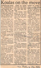
Article, Koalas on the move, 14/01/1986 12:00:00 AM
Article from 'The Post' 14 January 1986 about relocation of koalas by the Department of Conservation, Forests and Lands.Article from 'The Post' 14 January 1986 about relocation of koalas by the Department of Conservation, Forests and Lands.Article from 'The Post' 14 January 1986 about relocation of koalas by the Department of Conservation, Forests and Lands.wildlife, koalas, victoria. department of conservation forests and lands -
 Whitehorse Historical Society Inc.
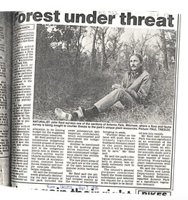
Article, Forest under threat, 13/09/1986 12:00:00 AM
An article in the Nunawading Gazette, naturalist John Reid has asked Council to commission a survey of flora and fauna of Antonio Park, Mitcham before this significant bushland remnant is impossible to save.native plants, antonio park, mitcham, reid, john, robinson, randall, victoria. department of conservation forests and lands -
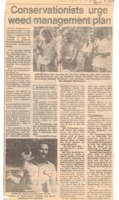 Whitehorse Historical Society Inc.
Article, Conservationists to urge weed management plan, 5/04/1989 12:00:00 AM
Article from Nunawading Gazette dated 5 April 1989 about a weed management plan in the City of Nunawading.environment, weeds, victoria. department of conservation, forests and lands., native plants, edwards, margaret, meagher, dorothy, witherspoon, cameron, david -
 Old Colonists' Association of Ballarat Inc.
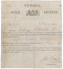
Document - Gold License, Gold License Issued to William Fittall in the Upper Loddon District, 1851, 10/1851
This miner's right is a copy from an original held by the Old Colonists' Association of Ballarat. The original was glued onto a page in a large album of photographic images of early Ballarat. Recognising their significance the Council of the Old Colonists’ Association had them removed and restored. The originals are now framed and on display in the Old Colonists’ Hall.Digital image of an original gold license made out to William Fittall Junior.14 Victoria Gold License No 144 1 June 1852 The Bearer William Fittall Jr having paid to me the sum of One Pound, Ten Shillings, on account of the territorial revenue, I hereby License him to dig, search for, and removed Gold on and from any such Crown lands within the Upper Loddon District as I shall assign to him for that purpose during the Month of June 1852 not within half-a-mile of any Head Station. This License is not transferrable, and to be produce whenever demanded by me or any other person acting under the authority of the government, and to be returned when another License is issued. [Undecipherable signature] Commissionerwilliam fittall, upper loddon, mining, old colonists' association, fittall, eureka