Showing 420 items
matching localities
-
 Bendigo Historical Society Inc.
Document - MINING REPORTS - LINE OF REEF AT YANKEE CREEK NEAR BENDIGO
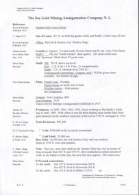
BHS CollectionTyped photocopy of a letter dated September 19th, 1898 from W. H. Cundy, Underground Survey Office, Bendigo. Letter refers to a locality, eight miles due east from Bendigo, and five miles west from Hunt's line of Reef Ellesmere. The writer did not think there was any necessity for a special survey to define the position of the reef. Handwritten at the bottom of the letter: for Report by Whitelaw See Progress Report No 10.document, gold, mining reports, mining reports, line of reef at yankee creek near bendigo, underground survey office bendigo, c tillach, koch's pioneer battery, mr grieve, hallidays claim, w h cundy, whitelaw -
 Ringwood and District Historical Society
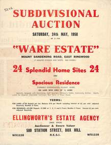
Flyer, Subdivisional Auction Sale Brochure, Ware Estate, East Ringwood, Vic. - 1958
Folded double-sided advertisement for auction of 24 home sites and existing residence on Saturday, 24th May, 1958, including locality map, subdivision layout, terms of sale, and summary of local facilities and services. Additional plan of lots 28-33 dated 26/10/60 by Licensed Surveyor for Kirkpatrick & Webber, 225 Maroondah Highway Ringwood headed Plan of Subdivision of part of Crown Allotment 26A Parish of Ringwood.Subdivision includes Mount Dandenong Road, Ware Crescent, Davey Drive, and Grey Road (later Grey Street). Timber residence included in the subdivision was formerly Ware Kindergarten Holiday Home. (Agent) Ellingworth's Estate Agency, 580 Station Street, Box Hill - (Phone) WX1228. -
 Bendigo Historical Society Inc.
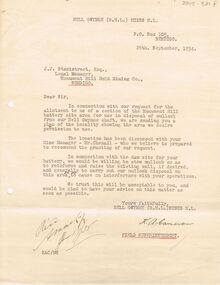
Document - MCCOLL, RANKIN AND STANISTREET COLLECTION: NELL GWYNNE MINES LETTER
Letter to J.J. Stanistreet, Legal Manager, Monument Hill Gold Mining Co., Bendigo from Nell Gwynne Mines N.L., dated 26th September 1934. Letter in connection with our request for the allotment to us of a section of the Monument Hill battery site area for use in disposal of mullock from our Nell Gwynne shaft. Mentions raising wall of existing wall of dam. Plan of the locality attached. See 2205.846.bendigo, business, nell gwynne mines n.l. -
 Ringwood and District Historical Society
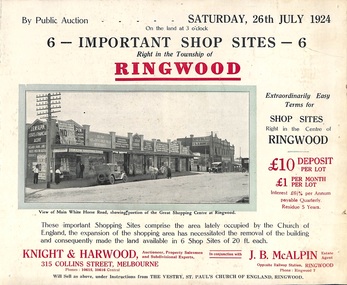
Flyer, Shop Sites Sale By Public Auction, Ringwood, Victoria - 1924
Folded double-sided brochure advertising six Ringwood shop sites for sale by Public Auction at 3pm, Saturday, July, 1924, with town photographs, location map, and summary of local features and services. Includes newspaper extract from the Real Estate and Property section from "Evening Sun", 6th June, 1924.Locality plan highlights shop sites for auction east of Pratt Street along Whitehorse Road. (Agents) Knight & Harwood, 315 Collins Street, Melbourne, Phones 10615, 10616 Central, in conjunction with J.B. McAlpin, Estate Agent, Opposite Railway Station, Ringwood, Phone Ringwood 7. -
 Melbourne Tram Museum
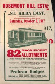
Ephemera - Real estate sale, Prahran Hodges, "Rosemont Hill Estate", Oct. 1917
Pamphlet advertising the sale of land at the "Rosemont Hill Estate", Balaclava Road, St Kilda East, 6-10-1917. On the front cover has a photo of PMTT tram No. 27. Gives terms of sale, the plan of the subdivision, and a general locality plan showing tram and rail lines. Land prices have been written in for some blocks on the pamphlet. Demonstrates the style of land sale pamphlet including the availability of tram services to prospective purchasers.Pamphlet - folded - printed in two colours of cream coloured paper with photographs and plans.has pencil notes re sale price and notes for some blocks.sale of land, trams, real estate, balaclava road, st kilda east, pmtt, tram 27, rosemont hill estate -
 Bendigo Historical Society Inc.
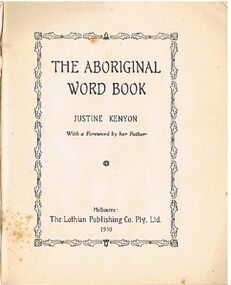
Book - ALEC H CHISHOLM COLLECTION: BOOK ''THE ABORIGINAL WORD BOOK'' BY JUSTINE KENYON
Book. ALEC H CHISHOLM COLLECTION. Two copies of a booklet of Aboriginal words, their meaning and locality. Includes Tasmanian words. A foreword 'The Speech of the Australian Aboriginal' by the author's father, A. S. Kenyon. Photo of an aboriginal male on covers. Published by the Lothian Publishing Co. and printed by Hassell Press, Adelaide. Copy 4000.235a First edition 1930 4000.235b Second edition 1951. Catalogue stickers ''2232.1 KEN'' and ''2232.2 KEN'' on front covers.Justine Kenyonbooks, collections, etymology, alec h chisholm collection, justine kenyon, aboriginal words -
 Kew Historical Society Inc
Plan - Subdivision Plan, Palmyra Estate, 1918
Pru Sanderson, in her groundbreaking ‘City of Kew Urban Conservation Study : Volume 2 - Development History’ (1988), summarised the periods of urban development and subdivisions of land in Kew. The periods that she identified included 1845-1880, 1880-1893, 1893-1921, 1921-1933, 1933-1943, and Post-War Development. These periods were selected as they represented periods of rapid growth or decline in urban development. An obvious starting point for Sanderson’s groupings involved population growth and the associated economic cycles. These cycles also highlighted urban expansion onto land that was predominantly rural, although in other cases it represented the decline and breakup of large estates. A number of the plans in the Kew Historical Society’s collection can also be found in other collections, such as those of the State Library of Victoria and the Boroondara Library Service. A number are however unique to the collection.The Kew Historical Society collection includes almost 100 subdivision plans pertaining to suburbs of the City of Melbourne. Most of these are of Kew, Kew East or Studley Park, although a smaller number are plans of Camberwell, Deepdene, Balwyn and Hawthorn. It is believed that the majority of the plans were gifted to the Society by persons connected with the real estate firm - J. R. Mathers & McMillan, 136 Cotham Road, Kew. The Plans in the collection are rarely in pristine form, being working plans on which the agent would write notes and record lots sold and the prices of these. The subdivision plans are historically significant examples of the growth of urban Melbourne from the beginning of the 20th Century up until the 1980s. A number of the plans are double-sided and often include a photograph on the reverse. In 1918, Punch reported the sale of the Palmyra Estate. ‘Adjoining the Findon Estate at Kew is Palmyra, one of the most charming localities in this most desirable of all suburbs. Palmyra has frontages to Findon, Bakewell, Carson and Stevenson streets. Facing Carson street are eight blocks of 60 by 140; on Stevenson-street four of 60 by 232; and there are four of 60 by 233 on Bakewell-street.’ [Bakewell Street and Findon Street were later to be amalgamated into Findon Crescent.]subdivision plans - kew, studley park, palymyra estate, stevenson street -- kew (vic.), carson street -- kew (vic.), bakewell street (findon crescent) -- kew (vic.) -
![View of the Township of Mt. Blackwood / [by] Nicholas Caire, circa 1876](/media/collectors/550653872162f11fb04854aa/items/57830cfbd0cdd1176c424e00/item-media/57830d7ad0cdd1176c428423/item-fit-380x285.jpg) Kew Historical Society Inc
Kew Historical Society IncPhotograph, Anglo-Australasian Photographic Company, View of the Township of Mt. Blackwood, c. 1876
Nicholas Caire was born on Guernsey in the Channel Islands in 1837. He arrived in Adelaide with his parents in about 1860. In 1867, following photographic journeys in Gippsland, he opened a studio in Adelaide. From 1870 to 1876 he lived and worked in Talbot in Central Victoria. In 1876 he purchased T. F. Chuck's studios in the Royal Arcade Melbourne. In 1885, following the introduction of dry plate photography, he began a series of landscape series, which were commercially successful. As a photographer, he travelled extensively through Victoria, photographing places few of his contemporaries had previously seen. He died in 1918. Reference: Jack Cato, 'Caire, Nicholas John (1837–1918)', Australian Dictionary of Biography.An original, rare photograph from the series 'Views of Victoria: General Series' by the photographer, Nicholas Caire (1837-1918). The series of 60 photographs that comprise the series was issued c. 1876 and reinforced a neo-Romantic view of the Australian landscape to which a growing nationalist movement would respond. Nicholas Caire was active as a photographer in Australia from 1858 until his death in 1918. His vision of the Australian bush and pioneer life had a counterpart in the works of Henry Lawson and other nationalist poets, authors and painters.‘View of the Township of Mt. Blackwood’ : Views of Victoria (General Series) No.42 : Albumen silver photograph | Photo on card with Title and Description on reverse | Mounted 24 x 30 cm; Photo 12 x 17 cm.On Reverse: ‘The locality which this illustration represents was formerly known as the Blackwood Forest, and has been the scene of considerable mining activity. The shallow alluvial diggings of the early days have given place to the deep sinking in search of reefs. This scene is characteristic of the wild appearance which many of the inland townships of Victoria represent.’nicholas caire (1837-1918), blackwood (vic), mount blackwood, landscape photography - victoria -
 Bendigo Historical Society Inc.
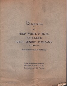
Document - MCCOLL, RANKIN AND STANISTREET COLLECTION: RED WHITE AND BLUE EXTENDED GM - PROSPECTUS, 1940
Documents: prospectus - 8 page booklet, inside back cover attached diagram - longitudinal section Sheepshead Line of Reefs - Bendigo , Locality plan shows Nell Gwynne Line, New Chum Line, sheepshead line, Deborah line, transverse section for Sheepshead line. Prospectus of Red White and Blue Extended Gold Mining Company No Liability Sheepshead Reef, Bendigo to be incorporated under the provisions of part 2 of the companies Act 1938, Victoria.MCCOLL RANKIN STANISTREETorganization, business, gold mining - legal, mccoll rankin stanistreet, red white and blue extrended gold mining company, nell gwynne line, new chum line, sheepshead line, deborah line. -
 Bendigo Historical Society Inc.
Document - STATE RIVERS AND WATER SUPPLY COMMISSION : GENERAL DESCRIPTION AND PARTICULARS OF EPPALOCK PROJECT, 1/08/1961
State Rivers and Water Supply Commission. Seven-page typed document titled 'General description and particulars of the Eppalock Project.' Subheadings: General, Administration and Works Installation, Field laboratory, Construction programme, Design statistics, Major items of plant in use on the project, Progress to 1st August 1961, Eppalock Reservoir Locality Plan (diagram), Eppalock project works area & arrangement plan (diagram), Eppalock Project cross section of dam along? tunnel (diagram).state infrastructure, water supply, coliban system, state rivers and water supply commission. coliban system. eppalock. -
 Bendigo Military Museum
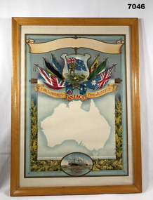
Certificate - CERTIFICATE, FRAMED, Goldsworthy & Davey Artists, WW1
Red print on Certificate template. "For Liberty ANZACS FOR JUSTICE". This is a blank certificate.Certificate - paper, red print on scroll, illustrated in colour - top to bottom, blank scroll; 2 soldiers and flag surrounded by 6 flags, silhouette in white of Australian map, oval shape with ship and troops. Further side decoration yellow and green wattle flowers and foliage. Pale blue background. Certificate template - possibly available to Shires and localities to customise as required. frame - timber, with varnish finish in natural tones, glass front and cardboard back.framed, ww1, certificate -
 Wodonga & District Historical Society Inc
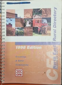
Book - North East Rural Directory 1998
The CFA North East Rural Directory for Regions 23 and 24 was designed to assist fire brigades and other emergency services in responding to calls in the North East region of Victoria. Its purpose was to minimize response times to emergency situations by providing accurate and detailed information about all of the localities in the regions. District 23 is based at Wangaratta and Extends as far south as Woods Point. District 24 is centred in Wodonga and extends past Corryong to the New South Wales border following the Murray River. It also includes Falls Creek and Mount Hotham.A spiral bound volume including colour topographic maps and illustrations of North East Victoria. The cover features a collage of colour photo of North East Victoria including a CFA firefighter in a truck with members of his family beside it. The book also features a key map, explanation of map references and symbols, localities index. Alphabetical road indexes for Wodonga, Albury, Wangaratta and Benalla as well as township maps and alphabetical road indexes for smaller communities are included.The CFA North East Rural Directory for Regions 23 and 24 was designed to assist fire brigades and other emergency services in responding to calls in the North East region of Victoria. Its purpose was to minimize response times to emergency situations by providing accurate and detailed information about all of the localities in the regions. District 23 is based at Wangaratta and Extends as far south as Woods Point. District 24 is centred in Wodonga and extends past Corryong to the New South Wales border following the Murray River. It also includes Falls Creek and Mount Hotham.emergency management north east victoria, cfa region 24, cfa wodonga, cfa region 23 -
 Orbost & District Historical Society
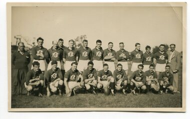
Photograph - Orbost Football Club 1945
This photograph was taken in 1945, as WW2 was ending. It shows Orbost men who are members of the Orbost Football Club, their Club trainer, and Club President. Football has always been a strong and well-supported sport in the Orbost district, with two teams in Orbost, another at Newmerella and outlying localities. These days (2023), there is only one club still existing in Orbost with a clubhouse and football field at Lochiel Park.Evidence of Orbost Football Club, 1945A b/w photograph of a group of 20 men wearing jumpers with a logo OFC and two other men in suits. This is a posed photograph with men at the back standing, and men at the front kneeling. It has been taken on a sportsfield. On back of photo: Orbost Football Club 1945. Back row L-R Artie Young (trainer), Alex McDonald, Mac Lock, Rick Railey, Tom Wehner, Bill Murphy, Clarrie Stevens, Ray Smith, Alan Hammond, -------------, Clyde Lynn, Maurice Marshall, John Stoddard (President) Front row L-R ----------------, ----------------, Reg Kettyle, Ray Cooney, George Watson, --------------, Sam Lynn, Jim Lynn, ...Parsonssport, football, orbost football club -
Glen Eira Historical Society
Document - Helenslea, Shelford CEGGS
Three copies of a photocopied fold out brochure relating to the auction of 48 lots in the Helenslea Estate on 25/03/1916. The brochure references St Mary’s Church, shops on Glen Eira Road, Caulfield Grammar School, and existing homes in the vicinity and includes photographs of these localities. Reference is also made to available public transport and trees on the Estate. The brochure also includes an illustrated bird’s eye map of the Estate.helenslea estate, glen eira road, st kilda east, mansions, orrong road, balaclava road, caulfield grammar school, fosberry avenue, st mary’s church, land subdivision, land brochures, residential development, auctions, caulfield north -
 Bacchus Marsh & District Historical Society
Map, Maddingley Township, Parish of Parwan, County of Grant, 1856
Maddingley is a locality or township within the broader township area of Bacchus Marsh. This map is dated 1856 but is based on an earlier survey in 1843. The main area of Maddingley shown on this map is an area bounded by Bacchus Street, Moore Street, Griffith Street and Franklin Street. Other streets visible are Inglis Street, Labilliere Street, McCrae Street. The area to the east of Franklin Street is not sub-divided and is described as an 'alluvial flat. A single page paper map showing land allotments, streets, and natural watercourses in the township of Maddingley. The map is pasted into a bound volume containing 76 maps or plans in total. Two inscriptions: 1. A.J. Skene Surveyor, 1843. ; 2. Surveyor-General's Office Melbourne, Sept 6, 1856. (Lithographed by R. Meikle)bacchus marsh victoria maps, maddingley victoria maps, land use, maddingley victoria history -
 Federation University Historical Collection
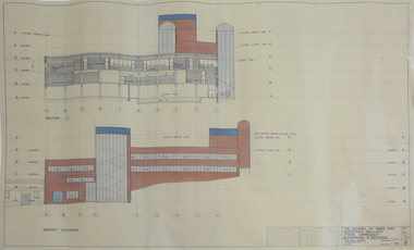
Plan - Plans, Ballarat School of Mines Albert Street Buildings, 1979
The Trade Workshops became known as the M.B. John Building, and later housed Ballarat Tech.Eight printed plans with coloured shading of SMB Albert St buildings: .1) Locality Plan .2) Trade Workshop Site Plan .3) Trade Workshop Floor Plan Level A & B .4) Trade Workshop Floor Plan Level C .5) Trade Workshop Floor Plan Level D .6) Trade Workshop Floor Plan Level E .7) Trade Workshop West Elevation and Sections .8) Trade Workshop North Elevations and Sections building plans, smb trade workshops, ewan jones and associates pty ltd, architectural plan, m.b. john building, albert street -
 Bendigo Historical Society Inc.
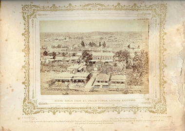
Photograph - VIEWS OF BENIDGO: LOOKING EAST FROM ST.PAUL'S CHURCH, 1875 copy,1970
Sepia photo on a cream board. Shows houses viewed east from St.Pauls Church. Inscription: 'Views of Bendigo|No.41.'. Below, 'Scene taken from St. Paul's tower, looking Eastward.', 'N.J.Caire Photo, Sandhurst'. Bottom, 'Casey & Wenborn's Print Forbes & Holmes, Agents',' This view represents the locality of the Back Creek gold digging, and though at present almost deserted, was once a scene of activity, in consequence of the rich patches of alluvial ground it contained'. Nicholas CaireN.J.Caireplace, bendigo, view east from st.paul's church, see: 'views of bendigo' by n.j.caire, 'mp?' -
 Bendigo Historical Society Inc.
Document - GREAT EXTENDED HUSTLERS MINE - NOTES ON THE GREAT EXTENDED HUSTLERS MINE
One hand written and three typed copies of notes on the Great Extended Hustlers Mine. Notes include locality, plant, early history, Prominent and Leading, Dividends and Yield, Bendigo's Worst Mining Accident, and a note of where the poppet legs were taken. Ref: Mines Dept Booklet 'Bendigo Goldfields 1936, Mines Dept Annual and Quarterly Reports, Mines Dept Bulletin 33 H Herman 1914, Annals of Bendigo Mining Sections 1870 - 1925, A Richardson,mine, gold, great extended hustlers., great extended hustlers mine, notes on the great extended hustlers mine, bendigo's worst mining accident, herbert thomas, walter blair, william ryan, george forster, john campbell, leslie martin, frederick chinn, wattle gully gold mine at chewton -
Bendigo Historical Society Inc.
Postcard - GREAT EXTENDED HUSTLERS MINE - POSTCARD OF POPPET LEGS & BUILDINGS
Grey & white postcard showing poppet legs and buildings at the Great Extended Hustlers Mine. Printed on the back: 'Royal Historical Society of Victoria Bendigo Branch. Great Extended Hustlers Locality: Hustlers Hill, Nth. Bendigo Formed 1865 - Last production 1921 Depth of shaft - 3,470 feet Poppet Legs - Steel, 70 feet high Winding Engine: First motion, 8 ft. Drums. Gold Very Rich Total yield - 300,000 ozs. Dividends 675,000 Poundsmine, gold, great extended hustlers., great extended hustlers mine, postcard of poppet legs and buildings, hustlers hill nth bendigo -
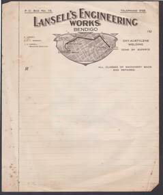 Bendigo Historical Society Inc.
Document - CAMBRIDGE PRESS COLLECTION: ACCOUNT - LANSELL'S ENGINEERING
Note/account paper with brown printed letterhead. Date line with 192-. Lansell's Engineering Works Bendigo across the top. Below is a shape with a locality plan of Bendigo and a dark brown line going from Charing Cross to Lansell's Engineering Works via View St, Barnard ST and Inglewood Rd where it turns left into a smaller unnamed street. On the left are the names of E. Lansell, E F V Norbury and L V Lansell (Managing Director).business, printers, cambridge press, cambridge press collection, lansell's engineering works, charing cross, sterry's hotel, lansell's 180, e lansell, e f v norbury, l v lansell -
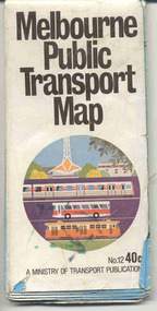 Ballarat Tramway Museum
Map, Ministry of Transport, "Melbourne Public Transport Map" - "No. 12", 1982
Pocket size - folded - public transport map of Melbourne, printed in colour on paper, showing public transport services in greater Melbourne, including ticketing information, travelcards and an index of localities. The Central zone area shown in detail. On the rear, route numbers and line maps of tram routes and train lines or services and fare zones. The first map with the new three zone system of fares. Includes private bus routes. Printed 1982 by Government Printer. Issue No. 12.On inside, a circle route around Flinders, Queen, Little Collins and Swanston St in blue felt pen and arrow in blue ink. On the rear, a sketch map showing the location Charles St, Mantell St and William Road, and a circle around Upfield station.trams, tramways, melbourne, map, routes -
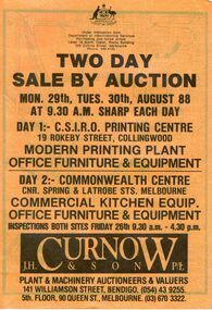 Bendigo Historical Society Inc.
Document - IAN DYETT COLLECTION: AUCTION CATALOGUE - C.S.I.R.O. PRINTING CENTRE & COMMONWEALTH CENTRE
Yellow covered auction catalogue with black printing for a sale on 29th and 30th August 88 under instructions from Department of Administrative Services Purchasing and Sales Group held at C.S.I.R.O. Printing Centre, Collingwood and the Commonwealth Centre, Melbourne. For sale was Modern Printing Plant, Office Furniture & Equipment at the Printing Centre and Commercial Kitchen Equip., Office Furniture & Equipment at the Commonwealth Centre. J. H. Curnow & Son P/L were the auctioneers. Locality map inside front cover.business, auctioneers, j h curnow & son pty ltd, ian dyett collection - auction catalogue - c.s.i.r.o. printing centre & commonwealth centre, department of administrative services purchasing and sales group, j h curnow & son p/l, fred'k c dyett, noel f dyett, ian m dyett, bolton bros pty ltd -
 Bendigo Historical Society Inc.
Document - LANDS OFFICE - INDEX OF CORRESPONDENCE 1964 - 1974, 1964-74
Journal: LANDS OFFICE - INDEX OF CORRESPONDENCE 1964 - 1974 Blue hard cover with red spine and corners. Contains blue lined pages with details of correspondence received/sent. Details include serial number, local number, correspond. Number, name, locality, type, date received, f/book, marking, precis. On spine of book 'ZZ' on white sticker. Written in front page in biro 'walking down the street so fancy free with another guy that could be me'Lands Officeplace, lands office, bendigo, sandhurst, land sales, correspondence -
 Bacchus Marsh & District Historical Society
Map, Bullengarook Parish, County of Bourke
An undated parish plan map for the parish of Bullegarook. This parish area is close to the Bacchus Marsh district and borders some of the areas contained within the former Bacchus Marsh Shire and present day Moorabool Shire.A single page paper map showing the parish plan map for Bullengarook. This parish area contains the locality of Bullengarook and parts of the Wombat State Forest and is close to the town of Gisborne. A cadastral map showing land ownership. The map is not dated but a very similar map held by the State Library of Victoria is estimated to date from about 1927. The map is pasted into a bound volume containing 76 maps or plans in total. High resolution digital image stored on BMDHS computer network. bullengarook parish maps -
 Bendigo Historical Society Inc.
Document - THE SEA GOLD MINING AMALGAMATED COMPANY N. L. - NOTES ON THE SEA GOLD MINING
Carbon copy of notes, with typed copy of same, on The Sea Gold Mining Amalgamated Company N. L. on the Garden Gully Line of Reef. Notes include size of lease, office, locality of shaft, sill and depth of shaft, plant, first & last crushing, Prominence, call and dividends, gold yield, best gold and underground connections. Signed by A Richards. Written at the top of page: Original to Mr R Leach, Manager, Allan's Music . Notes prepared by Albert Richardson.document, gold, the sea gold mining amal coy n l, the sea gold mining amalgamated company n. l., notes on the sea gold mining amalgamated company n. l., mccoll & rankin, mines dept plan 1937, annals of bendigo mining sections, g brown bendigo goldfield 1936, wood & mcnair s'brokers 1912, v pabst bendigo goldfields central area 1917, mines dept records, a richardson -
 Bendigo Historical Society Inc.
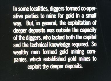
Slide - DIGGERS & MINING. DIGGERS AND MINERS, c1850s
BHS CollectionDiggers & Mining. Diggers and miners. In some localities, diggers formed co-operative parties to mine for gold in a small way. But, in general, the exploration of deeper deposits was outside the capacity of the diggers, who lacked both the capacity of the diggers, who lacked both the capital and the technical knowledge required. So wealthy men formed gold mining companies, which established gold mines to exploit the deeper deposits. Markings: 23 994:LIF I. Used as a teaching aid.hanimounteducation, tertiary, goldfields -
Bendigo Historical Society Inc.
Document - Great Extended Hustler's mines, April, 2014
Seven men were killed at the Great Extended Hustler's mine disaster on 2nd May 1914 by an explosion of dynamite occurring as the men were waiting at the plat to ascend the mine at the end of their shift. No blame was attached to anyone in the findings of the inquisition. It was unknown what caused the dynamite to explode. Three page typed document written by Albert Richardson. First page: Great Extended Hustler's including. Great Extended Hustlers Tribute of Pups Shaft, Hustler's line of reef. Mine formed in 1865, closed down 1925 or 1926. Locality, area of lease, depth of shaft, plant , early history, prominent and leading mines and best gold obtained from the mines is discussed. Poppet heads of the Great Extended Hustlers to the Stanfield mine at Long Gully and then to the Wattle Gully mine at Chewton.great extended hustlers, goldmining, accident, quartz, mining, k.k. mine, comet mine, hustler's line of reef, old comet, united hustler's, redan, poppet head, chewton, stanfield gold mine, wattle gully gold mine -
 Ringwood and District Historical Society
Flyer, Land Sale Advertisement - Sunbeam Estate, East Ringwood, Victoria - circa 1930
Folded double-sided page advertising private sale of 48 residential allotments, with location map, terms of sale, and details of local features and services. Locality plan includes Holland Road, Everard Road, Sunbeam Avenue, Mount Dandenong Road, and Lilydale Road (later Old Lilydale Road). (Agents) Phillips & Nicholson, 59 Swanston Street, Melbourne, (Phone) Central 10907, in conjunction with C.E. Carter, Bank Chambers, Main Street, Ringwood, Telephone Ringwood 24. -
![Fern Grove, near Mount Munday / [by] Nicholas Caire, circa 1876](/media/collectors/550653872162f11fb04854aa/items/57774d68d0cdd10a5c144296/item-media/57774e07d0cdd10a5c148099/item-fit-380x285.jpg) Kew Historical Society Inc
Kew Historical Society IncPhotograph, Anglo-Australasian Photographic Company, Fern Grove, near Mount Munday, c. 1876
Nicholas Caire was born on Guernsey in the Channel Islands in 1837. He arrived in Adelaide with his parents in about 1860. In 1867, following photographic journeys in Gippsland, he opened a studio in Adelaide. From 1870 to 1876 he lived and worked in Talbot in Central Victoria. In 1876 he purchased T. F. Chuck's studios in the Royal Arcade Melbourne. In 1885, following the introduction of dry plate photography, he began a series of landscape series, which were commercially successful. As a photographer, he travelled extensively through Victoria, photographing places few of his contemporaries had previously seen. He died in 1918. Reference: Jack Cato, 'Caire, Nicholas John (1837–1918)', Australian Dictionary of Biography, National Centre of Biography, Australian National UniversityAn original, rare photograph from the series 'Views of Victoria: General Series' by the photographer, Nicholas Caire (1837-1918). The series of 60 photographs that comprise the series was issued c. 1876 and reinforced a neo-Romantic view of the Australian landscape to which a growing nationalist movement would respond. Nicholas Caire was active as a photographer in Australia from 1858 until his death in 1918. His vision of the Australian bush and pioneer life had a counterpart in the works of Henry Lawson and other nationalist poets, authors and painters.Albumen silver photograph mounted on board‘The subject of this illustration is situated in one of the wildest and most romantic places in the Gipps Land ranges, about midway between Mount Munday and Mount Juliet. The foliage in this locality is very luxuriant, comprising mostly Fern Trees which are interwoven with various descriptions of grasses and stunted Fern leaves. Beneath this mass of vegetation flows a branch of the Contentment Creek.’landscape photography - victoria, nicholas caire, ferngrove - victoria